Kikuyu, Kenya

Last updated

Kikuyu
Kikuyu town.jpg
Kikuyu in 2009
Kenya adm location map.svg
Red pog.svg
Kikuyu
Location in Kenya
Coordinates: 1°15′S36°40′E / 1.250°S 36.667°E / -1.250; 36.667
CountryFlag of Kenya.svg  Kenya
County Kiambu County
Population
 (2019)
  Total323,881 [1]
Time zone UTC+3 (EAT)
Climate Cfb

Kikuyu is a town in Kiambu County, Kenya, which grew from a settlement of colonial missionaries. The town is located about 20 km (12 mi) northwest of central Nairobi. It is about 20 minutes from Nairobi via a number of routes, including a dual carriage road, and has a railway station on the Mombasa – Malaba Railway Line. The town is named after the Kikuyu/Gĩkũyũ people, the major ethnicity that settled in the area. As of 2019, the total population was 323,881. [2]

Contents

Due to its geology and rich soil texture, the chief activities are livestock and crop farming. The jurisdiction also includes the Ondiri Wetland which is the source of the Nairobi River. [3] [4] With the recent completion of the Southern Bypass that connects Mombasa to Nairobi via Kikuyu, the town is poised for greater growth as it is the only town on the Bypass. Kikuyu hosts a Sub-County Administration which is the administrative division in Kiambu County.

History

The town has some British colonial history links, like the Right Reverend Musa Gitau (Swahili for Moses Gitau), an African believer in democracy who led among the first Christian faithful during colonial times. He lived and worked in the town as a reverend and in his honour two schools were named after him.

An interdenominational missionary conference held in Kikuyu in June 1913 provoked the so-called Kikuyu controversy, which briefly roiled the Anglican churches from December 1913 to February 1914

Institutions within Kikuyu

Some of the major institutions in Kikuyu are;

1. Research Institutions

Kenya Forestry Research Institute (KEFRI), Kenya Agricultural Research Institute (KARI), and Kenya Trypanosomiasis Research Institute (KETRI)

2. Academic Institutions

University of Nairobi – Kikuyu Campus which hosts the College of Education and External Studies. It also hosts the Presbyterian University of Eastern Africa (PUEA), Thogoto Teachers Training College, Kikuyu Commercial College, Vantage Teachers College and Kismart College among others.

Secondary schools

Kikuyu is home to two National High Schools; Alliance High School and Alliance Girls High School. It also has several day and boarding schools including Kahuho Uhuru High School, Rungiri Secondary School, Uthiru Girls High School, Kikuyu Day Secondary School, Muhu Secondary School, Gichuru Memorial School, Musa Gitau Secondary School, Karai Day Secondary School, Kirangari High School, Moi Girls Kamangu, Green Garden Girls High School, Muguga High school, Star Sheikh Academies, Mary Leakey Girls School, Kevin Carey High School and Mai-a-ihii Secondary School.

Primary schools

Primary schools include Kikuyu Township Primary School, The Green Garden Schools, Jeverden Highlands Academy, Nderi Primary School, St. Veronica I.L.C, Kidfarmaco Primary School, Musa Gitau Primary School, Uthiru Genesis School, Muthiga Academy, Damacrest Schools, Patmos Montessori School, Mama Ngina Primary School, Fairlawns Primary School, Utafiti Primary School, Nguriunditu primary school, Kandeng'wa Primary School, Kid Zone School, Valley Crest Academy, Njumbi Primary School, Gicharani Primary School, Thogoto Primary School, Wambaa Primary School, Kanyiha Primary School, Magutuini Primary School, Thirime Primary School, Mai ai hii Primary School, Gikambura Primary School, Gacio School and Shalom Academy, Ellys school, Great Vision School, Golden Heights Academy, Roots Academy, Mabawa kids Academy.

Historical Sites

There are several historical sites within the town, such as the caves dug by Indian 'coollies' when constructing the Kenya-Uganda railway. These caves are found just below the town under the railway facing Magana farm. Other sites include the graves of two explorers who were killed by lions in the 19th century at Kanyariri, a few meters from where Fort Smith was situated; the Undiri swamp, and the PCEA Church of the Torch, the first building at Thogoto.

Transport

Transport to the capital and other places is available in form of matatus, minibuses and trains. It is also conveniently served through most Taxi – Cab services with rates averaging Kshs 1800 – 2500 (as of Jan 2016). Many institutions have developed in this town, including a major eye unit hospital, a Christian university, and many primary and secondary schools. Recreational facilities and accommodations include Sigona Golf Club, the Wida Highway Motel, Kari Holiday Retreat Centre, and the PCEA Lay Training Centre. It has developed into an industrial town that boasts many factories that range from the metallic to the medical sector.

Kikuyu town has a Universal Corporation factory, that was the first drugs company in Kenya to commercially produce Antiretroviral therapy drugs [5] (ARVs).

See also

Related Research Articles

Education in Kenya refers to the education system in Kenya. It is considered a basic right that should be offered to every individual. Education in Kenya predates to as early as the 18th century among the Swahili people. The earliest school was established by missionaries in Rabai. During the colonial era, the number of Kenyans with exposure to education steadily increased and a good number of them were privileged to proceed abroad for further education.

<span class="mw-page-title-main">Thika</span> Municipality in Kiambu County, Kenya

Thika is an industrial town and commerce hub in Kiambu County, Kenya, lying on the A2 road 42 kilometres (26 mi), northeast of Nairobi, near the confluence of the Thika and Chania Rivers. Although Thika town is administratively in Kiambu County, the greater Thika area comprising residential areas such as Bendor estate, Maporomoko, Thika Greens, Thika Golden Pearl, Bahati Ridge, and Thika Sports Club, among others, are within Murang'a County. Thika has a population of 279,429 which is growing rapidly, as is the entire greater Nairobi area. Its elevation is approximately 1,631 metres (5,351 ft).

Kiambu is a town in Kiambu County, Kenya. It is 14 km (8.7 mi) from the capital Nairobi. It is the capital of Kiambu County, which bounds the northern border of Nairobi. Other proximate towns are Ruiru, Gatundu, Limuru and Kabete.

<span class="mw-page-title-main">Machakos County</span> County in Kenya

Machakos County is one of the 47 counties of Kenya, which came into being because of the devolved system of governance occasioned by the 2010 constitution of Kenya. The country's first administrative headquarters are in Machakos Town, which is the largest town in the county. The county had a population of 1,421,932 as of 2019. The county borders Nairobi and Kiambu counties to the west, Embu to the north, Kitui to the east, Makueni to the south, Kajiado to the south west, and Muranga and Kirinyaga to the north west.

<span class="mw-page-title-main">John Arthur (missionary)</span>

John William Arthur was a medical missionary and Church of Scotland minister who served in British East Africa (Kenya) from 1907 to 1937. He was known simply as Doctor Arthur to generations of Africans.

<span class="mw-page-title-main">Presbyterian Church of East Africa</span> Religious organization in East Africa

Presbyterian Church of East Africa (PCEA) is a Presbyterian denomination headquartered in Nairobi, Kenya. In Kenya, 10% of the population is Presbyterian. It was started by missionaries from Scotland, most notable of whom was Dr John Arthur. It has its headquarters in Nairobi South C.

<span class="mw-page-title-main">Gatundu</span> Township in Kiambu County, Kenya

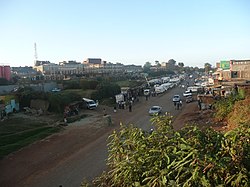
Gatundu is a small town in Kiambu County of Kenya. It is known for the first Kenyan president Jomo Kenyatta who lived about three kilometres away from the town, as well as his son, Uhuru Kenyatta, now the 4th President of Kenya and former Member of Parliament representing Gatundu South Constituency. The town is located on a hill surrounded by many farms and residences.

Karatina is a town in Nyeri County, Kenya which hosts a municipal council and serves as the headquarters of Mathira East district. Karatina municipality has a total population of 6,852, all classified as urban. It has six electoral wards, all in the Mathira Constituency; the remaining five wards of Mathira constituency represent Nyeri County Council.

Kibwezi is a town in Makueni County, Kenya.

<span class="mw-page-title-main">Margaret Kenyatta (mayor)</span> Kenyan politician

Margaret Wambui Kenyatta was a Kenyan politician. She was the daughter of the first President of Kenya, Jomo Kenyatta, and his wife Grace Wahu. She served as the mayor of Nairobi from 1970 to 1976 and as Kenya's Permanent Representative to the United Nations from 1976 to 1986. She was thereafter appointed as a Commissioner with the Electoral Commission of Kenya from 1992 to 2002.

Banana Hill is a suburb of Karuri town, in the eastern part of Kiambu County, Kenya. Banana Hill's population constitutes 20 percent of the estimated 100,000 residents within Kiambaa Constituency.

<span class="mw-page-title-main">Lari Constituency</span> Metro in Kenya

Lari Constituency is an electoral constituency in Kenya, located forty kilometers from Nairobi along the Nairobi-Nakuru highway. Lari is located in the Western part of Kiambu County. The constituency was established in 1966. Lari borders Kinangop to the North, Limuru to the South, Githunguri and Gatundu North constituencies to the east and Naivasha Constituency to the west. Lari is one of the 12 sub-counties in Kiambu County, and is further divided to five wards each electing a representative to the Kiambu County Assembly.

Dagoretti is an area in the western part of Nairobi, the capital of Kenya. It straddles the Nairobi and Kiambu County boundary with the Dagoretti Road Reserve marking the psychological border point heading Northerly and North-Easterly. Administratively it is one of eight divisions of Nairobi. The Dagoretti division is divided into six Locations. The former electoral Dagoretti Constituency had the same boundaries as the now defunct Dagoretti division.

Ndeiya is located in Kiambu County, Kenya, and is near the Great Rift Valley. The name is derived from a Maasai word.

<span class="mw-page-title-main">Kamulu</span> Neighbourhood in Nairobi

Kamulu is a neighbourhood in Nairobi City County located to the North East of the Nairobi Central Business District (CBD). It borders Joska (Matungulu) in Machakos County to the east, Mwalimu Farm Ruiru to the north, Njiru to the west, and Mihang'o to the south west.

<span class="mw-page-title-main">Uthiru</span> Suburb of Nairobi, Kenya

Uthiru is a settlement transversing in both Nairobi County and Kiambu County on the northwest side of the city centre of Nairobi. It is located between Kikuyu and Kangemi. The number of residents likely exceeds 100,000. It hosts a number of public institutions including University of Nairobi, Upper Kabete Campus, Kabete national polytechnic, and AHITI Kabete. ILRI has its headquarters in Uthiru.

<span class="mw-page-title-main">Jimwat</span> Kenyan rapper (born 1985)

James "Jim" Wathigo "Wat" Mburu,, better known by his stage names Jimwat and Jimweezy, is a Kenyan genge rapper.

References

  1. 2019 Kenya Population and Housing Census Volume II: Distribution of Population by Administrative Units; retrieved 25 February 2020.
  2. "Archived copy" (PDF). Archived from the original (PDF) on 23 February 2013. Retrieved 13 August 2013.{{cite web}}: CS1 maint: archived copy as title (link)
  3. "Friends of Ondiri Wetland Kenya | Home". friendsofondiriwetlands.org. Archived from the original on 23 July 2021. Retrieved 27 July 2021.
  4. Obura, Fredrick. "Increased human activities threaten source of Nairobi River - FarmKenya Initiative". Farm Kenya Initiative. Retrieved 27 July 2021.
  5. "Kikuyu factory produces first Kenyan-made ARVS". The Star. Retrieved 3 April 2024.