
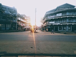
Kitale is an agricultural town in the northern Rift Valley, situated between Mount Elgon and the Cherangany Hills.The town has an elevation of around 1,900 metres (6,200 ft) Its population is 162,174 as of 2019. Kitale is the headquarter town of Trans-Nzoia County. Kitale is reachable by air through Kitale Airport. The postal code for Kitale is 30200.

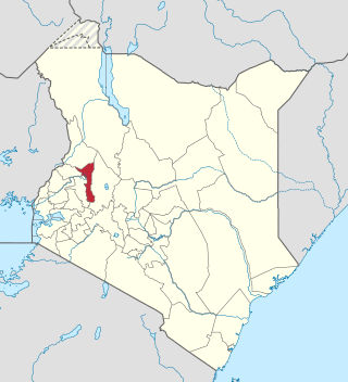
Trans-Nzoia County is a county in the former Rift Valley Province, Kenya, located between the Nzoia River and Mount Elgon, 380 km northwest of Nairobi. At its centre is the town of Kitale which is the capital and largest town. The county borders Bungoma to the west, Uasin Gishu and Kakamega to the south, Elgeyo-Marakwet to the east, West Pokot to the north and the republic of Uganda to the Northwest. Trans Nzoia covers an area of 2495.5 square kilometres.

The Luhya are a Bantu people and the second largest ethnic group in Kenya. The Luhya belong to the larger linguistic stock known as the Bantu. The Luhya are located in western Kenya and Uganda. They are divided into 20 culturally and linguistically united clans. Once known as the Kavirondo, multiple small tribes in North Nyanza came together under the new name Baluhya between 1950 and 1960. The Bukusu are the largest Luhya subtribe and account for almost 50% of the entire Luhya population, dominating other Luhya subtribes. They live in both Bungoma and Trans-Nzoia counties.

Uasin Gishu County is one of the 47 counties of Kenya located in the former Rift Valley Province. Eldoret has the county's largest population centre as well as its administrative and commercial centre. "It lies between longitudes 34 degrees 50' east and 35 degrees 37' West and latitudes 0 degrees 03' South and 0 degrees 55' North. It is a highland plateau with altitudes falling gently from 2,700 meters above sea level to about 1,500 meters above sea level. The topography is higher to the east and declines gently towards the western border".

Western Province was one of Kenya's seven administrative provinces outside Nairobi. It is inhabited mainly by the Luhya people. Quakerism is widely practised here. Kenya's second highest mountain, Mount Elgon is located in Bungoma District. The Kakamega Forest rainforest is part of the area. The province capital was Kakamega. After the 2013 general election, and the coming into effect of the new constitution, provinces became defunct and the country is currently divided into 47 counties. Each county has its own government and therefore there is no central regional capital. Western Province became the Western region, comprising four counties: Kakamega, Bungoma, Vihiga, and Busia.
Bungoma is the capital of Bungoma County in Kenya. It was established as a trading centre in the early 20th century. It is located in Kenya's fertile Western region and at the foot of Mount Elgon, Kenya's second-tallest mountain. The town and the surrounding areas boast one of Kenya's highest average rainfalls, making Bungoma one of the nation's most important food baskets.

Nyahururu is a town in Kenya, lying north east of Nakuru. The town derives its name from the Maasai word e-naiwurruwurr, meaning waterfall and/or windy or place of storms. It is allegedly located in Laikipia County. Despite this, Nyahururu formerly functioned as the administrative capital of Nyandarua District, before it became a county, until the headquarters was shifted to Ol Kalou. There have been calls for a reversal. The town has an urban population of 36,450. The town still continues to be a central economic power of the immediate former district of Nyandarua. For that reason, the town has strong economic ties to the two counties.

The Nzoia River is a 257-kilometre-long (160 mi) Kenyan river, rising from Cherangany hills. It passes through Kapsara, Springer, and Moi's Bridge then crosses to Kakamega county. It flows south and then west, eventually flowing into Lake Victoria near the town of Port Victoria.

Busia is a county in the former Western Province of Kenya. It borders Kakamega County to the east, Bungoma County to the north, Lake Victoria and Siaya County to the south and Uganda's Busia District to the west. The county population was 893,861, as of 2019. It spans about 1,700 square kilometers, making it one of the smallest counties in Kenya. Busia is inhabited by the Luhya tribe and the Teso of Kenya, and small groups of the Luo. The Luhya communities include the Abakhayo, Marachi, Samia and Abanyala communities.

Bungoma County is a county in the former Western Province of Kenya with its capital in Bungoma town. It has a population of 1,670,570 of which 812,146 are males and 858,389 are females as per the 2019 census and an area of 2,069 km2. It has nine constituencies, namely: Bumula, Kabuchai, Kanduyi, Kimilili, Mt. Elgon, Sirisia, Tongaren, Webuye East and Webuye West.

Local authorities in Kenya are the bodies controlling local governance in urban areas in Kenya.
Misikhu is a rural town on the southern slopes of Mt Elgon, in Bungoma County, Kenya. Located ten kilometres north of Webuye towards Kitale, Misikhu is both an administrative and commercial town.
Eusebius Juma Mukhwana is the past president of the African agricultural NGOs Network based in Ghana. He is also a recipient of the Kenyan head of state commendation (HSC) for his role in assisting farmers to improve their food security and income. He has dedicated much of his life and work to the plight of small scale farmers. Mukhwana is also the founder of the SACRED Africa.

The Tachoni is one of the tribes that occupy the western part of Kenya,its known for its gallant defense of the Chetambe in 1895 when resisting British rule. Tachoni people were masters at building forts such as Chetambe, Lumboka, and Kiliboti. It was their defiance of colonialism that led to the colonial government putting the entire region occupied by the Tachoni under administration of paramount chiefs drawn from Bunyala and Wanga communities. Sharing land with the Abanyala, the Kabras, Nandi, and Bukusu tribe. They live mainly in Webuye, Chetambe Hills, Ndivisi Matete sub-county-Lwandeti, Maturu, Mayoyo, Lukhokho, Kiliboti, Kivaywa, Chepsai, and Lugari sub-county in Kakamega County. Most Tachoni clans living in Bungoma speak the ' Olutachoni dialect which is a hybrid of the luhyia language of the luhyia people. Since they lost their original dialect during the divide and rule system used by the whites to scatter them for being resistants to their colonialism, they had to find a way to interact with their new neighbors and thats why they're subsequently mistaken as Bukusus. They spread from Kakamega county to Trans-Nzoia County, webuye especially around Kitale, Tambach in Iten Nandi in areas like kabiyet and kapsisiwa, kericho and to Uasin Gishu County near Turbo, Eldoret.
Among the Tachoni clans are Abachikha -further divided into Abakobolo, Abamuongo, Abachambai,Abamakhanga, Abacharia, and Abakabini, Abamarakalu, Abangachi -who are further divided into: Abawaila, Abakhumaya and Abawele, Abasang'alo, Abasamo, Abayumbu, Abaluu, Abarefu,Abanyangali, Abamuchembi, Abamakhuli, Abasioya, Abaabichu,Abacheo, Abamachina,Abaengele, Abamutama, Abakafusi, Abasonge, Abasaniaka, Abaabiya also known as Abakatumi, Abakubwayi,Abakamutebi, Abakamukong, Abamweya, Abalukulu,Abawande, Abatukiika, Abachimuluku. Note that the morpheme 'aba' means 'people'.
Bungoma Airport is an airport in Kenya.
Milo is a sub-location in Sitikho Location of Bungoma County, Kenya. It is headed by Emmanuel Murokoyo. It is located approximately 34 degrees east of the Greenwich Meridian and 30 minutes north of the equator. It is bordered by the Nzoia and Muji rivers. The area is heavily populated, with agriculture being the main economic activity: Maize, millet, sorghum, beans, bananas and sugarcane are some of the crops produced in this area. The population also engages in fishing, livestock keeping and bodaboda operations.
Elgeyo-Marakwet County is one of Kenya's 47 counties, which is located in the former Rift Valley Province with its capital and largest town as Iten. It borders the counties of West Pokot to the north, Baringo County to the east, southeast and south, Uasin Gishu to the southwest and west, and Trans Nzoia to the northwest.
Suam, Kenya is a settlement in the Trans-Nzoia County of Kenya. It sits across the Suam River from Suam, Uganda, at the international border between the two countries.
The Kisumu–Kakamega–Webuye–Kitale Road, is a rural road in Kenya. The road links Kisumu, in Kisumu County, to the towns of Kakamega, in Kakamega County, Webuye in Bungoma County, and Kitale in Trans-Nzoia County.
The Nairobi–Malaba Road, also Nairobi–Uganda Road or A104 Road (Kenya) is a major highway in Kenya, the largest economy in the East African Community. The road connects Nairobi, the capital and largest city in Kenya, with the border town of Malaba at the international border with Uganda.

