Horsforth

Last updated

Horsforth
TownStreetHorsforth.jpg
Town Street, Horsforth
Leeds UK location map.svg
Red pog.svg
Horsforth
West Yorkshire UK location map.svg
Red pog.svg
Horsforth
Location within West Yorkshire
Population18,895 (2011 Census) [1]
OS grid reference SE236376
Civil parish
  • Horsforth
Metropolitan borough
Metropolitan county
Region
Country England
Sovereign state United Kingdom
Post town LEEDS
Postcode district LS18
Dialling code 0113
Police West Yorkshire
Fire West Yorkshire
Ambulance Yorkshire
UK Parliament
Website horsforthtowncouncil.gov.uk
List of places
UK
England
Yorkshire
53°50′13″N1°38′35″W / 53.837°N 1.643°W / 53.837; -1.643

Horsforth is a town and civil parish in the City of Leeds, West Yorkshire, England, five miles north-west of Leeds city centre. Historically a village within the West Riding of Yorkshire, it had a population of 18,895 at the 2011 Census. [1] It became part of the City of Leeds metropolitan borough in 1974. In 1999, a civil parish was created for the area, and the parish council voted to rename itself a town council. The area is within the Horsforth ward of Leeds City Council, which also includes the southern part of Rawdon. [2]

Contents

History

Horsforth Museum Horsforth Museum.jpg
Horsforth Museum
The Home Front: Second World War display in Horsforth Museum HorsforthHomeFront.JPG
The Home Front: Second World War display in Horsforth Museum

Horsforth was recorded in the Domesday Book of 1086 as Horseford, Horseforde, Hoseforde; but late-ninth-century coins with the legend ORSNA FORD and OHSNA FORD may have come from Horsforth. The name derives from Old English hors or, to judge from the coins, *horsa ('horse') in the genitive plural form horsa/horsna + ford 'ford', thus meaning 'horses' ford'. [3] This refers to a river crossing on the River Aire (possibly at Newlay), that was subsequently used to transport woollen goods to and from Pudsey, Shipley and Bradford. The original ford was situated off Calverley Lane, but was replaced by a stone footbridge at the turn of the 19th century.

The three unnamed Saxon thegns that held the land at the Conquest gave way to the king who granted it to lesser Norman nobles, [4] but not long after most of the village came under the control of Kirkstall Abbey, a Cistercian house founded in 1152 on the bank of the River Aire downstream of Horsforth.

After the Dissolution of the Monasteries in 1539, Horsforth was partitioned and sold to five families, one of them – the Stanhopes – achieved supremacy and controlled the village for the next 300 years. The estate record of the Stanhopes is regarded as one of the most extensive and important collections of its kind, complementing the extensive medieval record associated with Kirkstall Abbey.

Until the mid 19th century, Horsforth was an agricultural community but it expanded rapidly with the growth of the nearby industrial centre of Leeds. A tannery business was founded at Woodside in about 1820 by the Watson family. It was on the eastern edge of their small farm, and memorialised by Tanhouse Hill Lane. The business became a soap manufacturer and moved to Whitehall Road in Leeds in 1861 and under the chairmanship of Joseph Watson junior, created Baron Manton in 1922, as Joseph Watson & Sons Ltd, became the largest soap supplier to the northeast of England, second in size nationally only to Lever Brothers. [5] Industrially, Horsforth has a history of producing high-quality stone from its quarries. Not only did it supply Kirkstall Abbey with building materials and millstones in the medieval period, it provided the stone for Scarborough's seafront and sent sandstone from Golden Bank Quarry as far afield as Egypt. Situated on Horsforth Beck (Oil Mill Beck) were mills serving the textile trade.

Between 1861 and 1862, there was an outbreak of typhoid. [6]

Horsforth was historically a township in the parish of Guiseley. It became a separate civil parish in 1866. [7] In the late-19th century it achieved note as the village with the largest population in England.[ citation needed ] Railways, turnpike roads, tramways and the nearby canal made it a focus for almost all forms of public and commercial transport and it became a dormitory suburb of Leeds. The civil parish became Horsforth Urban District in 1894. The parish and urban district were abolished in 1974 and merged into the new City of Leeds metropolitan district. In 1999 Horsforth became a civil parish and a parish council was created, which exercised its right to declare Horsforth a town. [8]

Horsforth Village Museum [9] has collections and displays illustrating aspects of life set against the backdrop of the changing role of the village.

During the Second World War the £241,000 required to build the corvette HMS Aubrietia was raised entirely by the people of Horsforth. In 2000 the US President Bill Clinton acknowledged Horsforth's contribution to the war effort in a letter sent to MP Paul Truswell. [10] The letter is in the museum.

In October 2020 Horsforth was named the most musical village in Britain as it was revealed that 22 home-grown acts were in the running for the charts with their latest singles. [11]

Transport

Rail

Horsforth station looking south towards Leeds Horsforth station.jpg
Horsforth station looking south towards Leeds
Newlay & Horsforth station with a freight train in 1964 Newlay & Horsforth station geograph-2165895.jpg
Newlay & Horsforth station with a freight train in 1964

Horsforth railway station is on the Harrogate line between Harrogate and Leeds. The station is just outside the Horsforth parish boundary, on the Cookridge side of Moseley Beck.

Kirkstall Forge railway station is located in Kirkstall near the boundary with Horsforth, around two miles from Horsforth station. It is on the Leeds to Bradford Line between Leeds City and Shipley and was opened on 19 June 2016, near the site of an earlier station with the same name.

Newlay station, which was built by the Midland Railway, was renamed Newlay & Horsforth station in 1889. It was situated south of the River Aire and was accessible from Horsforth on Pollard Lane which connects Horsforth to Bramley. [12] The station on the Airedale line was renamed Newlay station in 1961. It closed on 22 March 1965, along with other stations on the Airedale line: Armley Canal Road, Kirkstall, Calverley & Rodley and Apperley Bridge.

Bus

The town is served by several bus routes:

Airport

The nearest airport is Leeds Bradford Airport, in neighbouring Yeadon approximately 2.6 miles away.

Education

Leeds Trinity University, formerly Leeds Trinity University College, is an independent university after a period as an accredited college of the University of Leeds. The residential campus is located off Brownberrie Lane, Horsforth.

The further education college Leeds City College has a former site in Horsforth which was called the Horsforth Campus which has lain redundant since it closed in June 2017. Housing has now been built on the site. [14] It was previously part of Park Lane College.

The main secondary school is Horsforth School. [15] Horsforth's state sector primary schools are West End Lane Primary School, St Margaret's Primary School, Newlaithes Primary School, Westbrook Lane Primary School, Broadgate Lane Primary School, St Mary's Catholic Primary School and Featherbank Primary School.

Featherbank School opened in 1911 as a primary school, replacing the Grove Day School. The school's infant department was moved to the Grove Methodist Church on Stanhope Drive in 1933, but in 1960 transferred to the Featherbank School annexe. In 1972 Featherbank juniors (7–11 years) were allocated places at the newly built Newlaithes Junior School, at which point Featherbank became purely an infants' school (4–7 years). [16] In September 2011 Featherbank reverted to being a full primary school.

There is a private primary school, The Froebelian School.

Architecture

Flats in Horsforth St James Drive, Horsforth - geograph.org.uk - 829932.jpg
Flats in Horsforth

Horsforth has a large percentage of sandstone buildings sourced from local quarries, more than any other part of Leeds. A draft design statement [17] was produced in 2010, which summarises much of the architectural and historical character.

Churches

St Margaret's Church St. Margaret's Parish Church, Horsforth - geograph.org.uk - 83596.jpg
St Margaret's Church

The main churches in Horsforth are;

Scout and Guide hut

Scout and Guide hut 7th Airedale St Margaret's Scouts and Guides - New Road Side - geograph.org.uk - 1600453.jpg
Scout and Guide hut

The Scout and Guide hut on New Road Side was requisitioned during the Second World War as an emergency mortuary for the factories based around what is now Leeds Bradford Airport (Yeadon Aerodrome at the time), but it was never needed. [32] Before being purchased by the scouts and guides[ when? ], the building was used as a cafe, a popular stop-off on the way out to Otley, Ilkey and the Dales.

Sports clubs and facilities

Nightlife

Given its size, Horsforth has a relatively high number of bars and pubs of varying types from traditional pubs going back to the 17th century to more modern café bars and lounges. Horsforth Town Street has the highest concentration of these with several bars and pubs within a short distance of each other. Other popular night life areas include Station Road and New Road Side. [41]

Notable people

See also

Related Research Articles

<span class="mw-page-title-main">Guiseley</span> Town in West Yorkshire, England

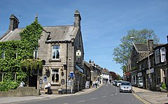
Guiseley is a town in metropolitan borough of the City of Leeds, West Yorkshire, England. Historically part of the West Riding of Yorkshire, it is situated south of Otley and Menston and is now a north-western suburb of Leeds.

<span class="mw-page-title-main">Kirkstall</span> Suburb of Leeds, West Yorkshire, England

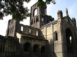
Kirkstall is a north-western suburb of Leeds, West Yorkshire, England, on the eastern side of the River Aire. The area sits in the Kirkstall ward of Leeds City Council and Leeds West parliamentary constituency, represented by Rachel Reeves. The population of the ward at the 2011 Census was 21,709.

<span class="mw-page-title-main">Yeadon, West Yorkshire</span> Town in West Yorkshire, England

Yeadon is a town within the metropolitan borough of the City of Leeds, West Yorkshire, England.

<span class="mw-page-title-main">Headingley</span> Human settlement in England

Headingley is a suburb of Leeds, West Yorkshire, England, approximately two miles out of the city centre, to the north west along the A660 road. Headingley is the location of the Beckett Park campus of Leeds Beckett University and Headingley Stadium.

<span class="mw-page-title-main">A65 road</span> Road in England

The A65 is a major road in England. It runs north west from Leeds in West Yorkshire via Kirkstall, Horsforth, Yeadon, Guiseley, Ilkley and Skipton, west of Settle, Ingleton and Kirkby Lonsdale before terminating at Kendal in Cumbria.

<span class="mw-page-title-main">Bramley, Leeds</span> Area of Leeds, West Yorkshire, England

Bramley is a district in west Leeds, West Yorkshire, England. It is part of the City of Leeds Ward of Bramley and Stanningley with a population of 21,334 at the 2011 Census. The area is an old industrial area with much 19th century architecture and 20th century council housing in the east and private suburban housing in the west.

<span class="mw-page-title-main">Cookridge</span> Suburb of Leeds in West Yorkshire, England

Cookridge is a suburb of north-west Leeds, West Yorkshire, England, north of the Leeds Outer Ring Road. In 1715 Ralph Thoresby described it as a village four miles from Leeds and three from Otley, dating from 1540.

<span class="mw-page-title-main">West Park, Leeds</span> Human settlement in England

West Park is a suburb of north-west Leeds, West Yorkshire, England, north of Headingley. It is a mixed area of private suburban housing and suburban council estates. The name derives from its main park containing playing fields together with a conservation area of grassy meadow ending in woodland. The largest housing estate in West Park is Moor Grange.

<span class="mw-page-title-main">Ireland Wood</span>

Ireland Wood is a small residential area in north-west Leeds, West Yorkshire, England named after the Woodland Trust wood which it contains. It is approximately 4 miles (6.4 km) to the north-west of Leeds city centre. It was planned by Leeds Housing Director RAH Livett and won the Ministry Housing medal for 1945-9. An early plan of Ireland Wood in 1950 is shown on the Leodis website.

<span class="mw-page-title-main">Rawdon, West Yorkshire</span> Village and civil parish in West Yorkshire, England

Rawdon is a village and civil parish in the metropolitan borough of the City of Leeds, West Yorkshire, England. It sits on the River Aire and on the A65 south of Yeadon.

<span class="mw-page-title-main">Leeds North West (UK Parliament constituency)</span> Parliamentary constituency in the United Kingdom

Leeds North West is a constituency in the City of Leeds which has been represented in the House of Commons of the UK Parliament since 2017 by Alex Sobel, of Labour Co-op.

<span class="mw-page-title-main">Aireborough</span> Former district in West Yorkshire, England

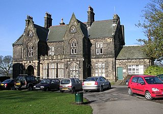
Aireborough was a local government district in the West Riding of Yorkshire, England from 1937 to 1974. It was formed through the abolition of the urban districts of Guiseley, Yeadon and Rawdon and enlarged by the addition of parts of Otley urban district and parts of the civil parishes of Esholt, Hawksworth and Menston in the Wharfedale rural district on 1 April 1937. Aireborough Urban District was administered from Micklefield House in Rawdon which had been acquired by Rawdon UDC in 1930. The district is, since 1974, part of Leeds and Esholt is in Bradford

<span class="mw-page-title-main">Moor Grange</span> Human settlement in England

Moor Grange Estate is a housing estate in the West Park area of Leeds, West Yorkshire, England, which was built in the 1950s on reclaimed farmland. Work on the Moor Grange Estate began in 1955. It was originally owned by the local council, and was leased by the council to tenants as a council estate. Most of the housing on the estate is now privately owned. Moor Grange does not suffer the crime problems of other council estates. House prices on the estate are high, and Moor Grange is considered a 'model council estate'. This may be due to the affluence of the area in which it is situated. Moor Grange backs onto the smaller Spen Estate which is another council estate in West Park. The Estate falls within the Kirkstall ward of the Leeds Metropolitan Council.

<span class="mw-page-title-main">Richmond Hill, Leeds</span> Human settlement in England

Richmond Hill is a district of Leeds, West Yorkshire, England. The district lies a mile to the east of the city centre between York Road, East End Park and Cross Green. The appropriate City of Leeds ward is Burmantofts and Richmond Hill.

<span class="mw-page-title-main">Burley, Leeds</span> Area of Leeds, West Yorkshire, England

Burley is an inner city area of Leeds, West Yorkshire, England, 1 mile (1.6 km) north-west of Leeds city centre, between the A65 Kirkstall Road at the south and Headingley at the north, in the Kirkstall ward.

Horsforth Woodside was a proposed railway station that was to be built on the site of Woodside Quarry near Horsforth in West Yorkshire, England. It would have been located on the Harrogate Line near the current Horsforth station, which would also stay open. Horsforth Woodside was also the name of a very early station on the Leeds-Northallerton railway, which was closed completely in 1864. The fact that both the old closed station and the proposed new station have the same name has caused confusion when railway historical matters in this area are being discussed. The proposed station would have served a planned housing development at the former Woodside Quarry, as well as providing a park and ride service for Leeds city centre.

<span class="mw-page-title-main">Chapel Allerton</span> Suburb of Leeds in West Yorkshire, England

Chapel Allerton is an inner suburb of north-east Leeds, West Yorkshire, England, 2 miles (3.2 km) from the city centre.

<span class="mw-page-title-main">Newlay</span> Suburb of Horsforth, West Yorkshire, England

Newlay is a suburb of Horsforth, in West Yorkshire, England. Originally a hamlet, it is now part of Horsforth parish in the City of Leeds District, and has its own conservation area. Newlay is situated on the Leeds and Liverpool Canal and the River Aire, some 5 miles (8 km) north west of Leeds city centre.

References

  1. 1 2 UK Census (2011). "Local Area Report – Horsforth Parish (1170211013)". Nomis. Office for National Statistics . Retrieved 24 April 2018.
  2. "Horsforth Ward" (PDF). Leeds City Council. 2015. Archived from the original (PDF) on 26 October 2021. Retrieved 17 May 2017.
  3. Watts, Victor; Gelling, John (2004). The Cambridge dictionary of English place-names : based on the collections of the English Place-Name Society (1 ed.). New York: Cambridge University Press. p. 3. ISBN   9780521362092.
  4. "Horsforth CA" (PDF). Leeds City Council. LCC. 10 November 2008. p. 5. Retrieved 26 November 2015.
  5. Wilson, Charles. History of Unilever, London, 1954. Vol.1
  6. Epidemiological Society of London, Transactions (in GoogleBooks). 1863. Retrieved 10 January 2012.
  7. "Horsforth CP/Ch through time - Census tables with data for the Parish-level Unit". www.visionofbritain.org.uk. Retrieved 8 April 2018.
  8. "Horsforth Town Council" . Retrieved 12 March 2024.
  9. "Horsforth Museum, Leeds – Yorkshire". UK Attraction. Archived from the original on 2 March 2012. Retrieved 10 January 2012.
  10. "Storm over U-boat film, BBC News, 2 June 2000". BBC News. 2 June 2000. Retrieved 10 January 2012.
  11. Express.co.uk, Leeds suburb is music hub of pop with 22 acts vying for charts, published 15 October 2020, accessed 13 November 2020
  12. "Multi Map". Multi Map. Retrieved 10 January 2012.
  13. "Timetables | Leeds | First UK Bus". First UK Bus. Retrieved 16 December 2017.
  14. Murphy, Lizzie. "Leeds City College site to be transformed into 152 affordable homes". Yorkshire Post. Retrieved 20 November 2023.
  15. "Horsforth school". Horsforth.leeds.sch.uk. Retrieved 29 July 2015.
  16. "school history". Featherbank.leeds.sch.uk. Archived from the original on 27 February 2012. Retrieved 10 January 2012.
  17. "Horsforth Design Statement" Archived 12 August 2011 at the Wayback Machine , requires Pdf download. Retrieved 10 January 2012
  18. "Lister Hill Baptist Church". www.lhbc.org.uk. Retrieved 10 January 2012.
  19. "Cragg Hill Congregation". South Parade Baptist Church. Archived from the original on 13 September 2012. Retrieved 10 January 2012.
  20. "St Margaret's Church Horsforth". Stmargaretshorsforth.org.uk. Retrieved 10 January 2012.
  21. "St James, Woodside". Stjameswoodside.org. Retrieved 10 January 2012.
  22. "The Kingdom Hall of Jehovah's Witnesses, Calverley Lane, Horsforth" Archived 24 September 2015 at the Wayback Machine , GENUKI.org.uk. Retrieved 10 January 2012
  23. "Central Methodist Church, Town Street, Horsforth, Leeds", Geograph.org.uk. Retrieved 10 January 2012
  24. "Grove Methodist Church, Horsforth, Leeds". Grovemethodist.org.uk. 6 January 2012. Retrieved 10 January 2012.
  25. Thomson, Richard; "Woodside Methodist Church, Outwood Lane, Horsforth, Leeds" Archived 24 September 2015 at the Wayback Machine , Genuki.org.uk. Retrieved 10 January 2012
  26. Horsforth Churches Together, Grovemethodist.org.uk. Retrieved 10 January 2012
  27. "St Mary's Roman Catholic Church, Horsforth" Archived 24 September 2015 at the Wayback Machine , Genuki.org.uk. Retrieved 10 January 2012
  28. "History of the Chapel" Archived 21 March 2015 at the Wayback Machine , Leedstrinity.ac.uk. Retrieved 10 January 2012
  29. Comboni Missionaries, Comboni.org.uk. Retrieved 10 January 2012
  30. , Ebcleeds.org.uk. Retrieved 7 August 2018
  31. , mosaic-church.org.uk. Retrieved 23 May 2020
  32. Sheerin, Joseph (22 February 2016). "What Horsforth Used to Look Like". leeds-list.com. Retrieved 24 April 2018.
  33. "Yarnbury RFC". Pitchero.com. Retrieved 24 April 2021.
  34. "Horsforth Saints FC". Pitchero.com. Retrieved 24 April 2021.
  35. "Horsforth St Margaret's FC" . Retrieved 24 April 2021.
  36. "Horsforth Cricket Club" . Retrieved 24 April 2021.
  37. "Horsforth Harriers Running Club". Horsforthharriers.co.uk. Retrieved 10 January 2012.
  38. "Horsforth Fellandale Running Club". Fellandale.com. Retrieved 7 August 2018.
  39. "Horsforth Throstle Nest Tennis Club" . Retrieved 24 April 2021.
  40. "LS18 Rocks" . Retrieved 24 April 2021.
  41. "Pubs In Horsforth - A Guide to the Bars and Pubs of Horsforth in Leeds". Pubs In Horsforth. Retrieved 8 April 2018.
  42. "'Once a Featherbanker...' Ed Miliband returns to the Horsforth school that fostered his love of Leeds United", Yorkshire Post, 14 October 2011. Retrieved 27 June 2012
  43. McIntyre, Annette ". . . and that he would never be a professional footballer", Telegraph & Argus, 24 June 2010. Retrieved 10 January 2012
  44. "Ralph Miliband biography, London School of Economics website". Lse.ac.uk. 24 November 2010. Archived from the original on 27 May 2010. Retrieved 10 January 2012.
  45. 1 2 Newton, Grace (10 March 2017). "Leeds suburb named one of England's best places to live". Yorkshire Evening Post. Retrieved 30 April 2018.
  46. Woodward, Grant (18 October 2005). "Kaiser kickabout". Yorkshire Evening Post. Retrieved 30 April 2018.
  47. Haywood, Jo (9 January 2016). "Ten reasons to love Horsforth". Yorkshire Life. Retrieved 24 April 2018.
  48. "Leeds artist rocking again with new show". Yorkshire Evening Post. 7 March 2016. Retrieved 30 April 2018.
  49. "Dave Stone: Horsforth cyclist wins second Paralympics gold – Sport – Yorkshire Evening Post". Horsforthtoday.co.uk. 17 September 2008. Retrieved 10 January 2012.
  50. "Jonny Clay in Horsforth Today". Horsforthtoday.co.uk. 27 August 2008. Retrieved 10 January 2012.
  51. Sobot, Lee (15 February 2014). "Motorsport: Tordoff confident of being in the touring car title race". Yorkshire Evening Post. Retrieved 30 April 2018.
  52. Greaves, Amanda (8 October 2010). "Kathryn to switch on Ilkley's Christmas lights". Ilkley Gazette. Retrieved 24 April 2018.