Saint Anthony Falls, or the Falls of Saint Anthony, located at the northeastern edge of downtown Minneapolis, Minnesota, is the only natural major waterfall on the Mississippi River. Throughout the mid-to-late 1800s, various dams were built atop the east and west faces of the falls to support the milling industry that spurred the growth of the city of Minneapolis. In 1880, the central face of the falls was reinforced with a sloping timber apron to stop the upstream erosion of the falls. In the 1950s, the apron was rebuilt with concrete, which makes up the most visible portion of the falls today. A series of locks were constructed in the 1950s and 1960s to extend navigation to points upstream.

The Stone Arch Bridge is a former railroad bridge crossing the Mississippi River at Saint Anthony Falls in downtown Minneapolis, Minnesota. It is the only arched bridge made of stone on the entire Mississippi River. It is the second oldest bridge on the river next to Eads Bridge. The bridge was built to connect the railway system to the new Union Depot, which at that time was planned to be built between Hennepin Avenue and Nicollet Avenue. The bridge was completed in 1883, costing $650,000 at the time. 117 Portland Avenue is the general address of the historic complex.

The Grand Rounds National Scenic Byway is a linked series of park areas in Minneapolis, Minnesota, United States, that takes a roughly circular path through the city. The Minneapolis Park and Recreation Board developed the system over many years. The corridors include roads for automobile traffic plus separate paths for pedestrians and bicycles, and extend slightly into neighboring cities. About 50 miles (80 km) of roadway and paths are in the system, and much of it was built in the 1930s as part of Civilian Conservation Corps projects.

The 10th Avenue Bridge crosses the Mississippi River near downtown Minneapolis, Minnesota and also in proximity to the University of Minnesota. The bridge historically was called the Cedar Avenue Bridge from days prior to the construction of the I-35W bridge when it connected to Cedar Ave. The bridge connects 10th Avenue Southeast, on the east side of the Mississippi River to 19th Avenue South, on the west side. The Seven Corners area of the Cedar-Riverside, Minneapolis neighborhood is at the south end of the bridge. The downstream end of the lower Saint Anthony Falls lock and dam extends under the bridge. The historic Southeast Steam Plant is also nearby.
Martin Sigvart Grytbak was Norwegian-born American engineer.

The Midtown Greenway is a 5.7-mile (9.2 km) rail trail in Minneapolis, Minnesota that follows the path of an abandoned route of the Milwaukee Road railway. It is considered under segregated cycle facilities.

The Twin Cities Assembly Plant is a former Ford Motor Company manufacturing facility in Saint Paul, Minnesota, United States, that operated from 1925 to 2011. In 1912, Ford's first assembly and sales activities in Minnesota began in a former warehouse in Minneapolis. By 1925, Ford had relocated its local operations to the bluffs above the Mississippi River in the Highland Park neighborhood of Saint Paul. In 2006, Ford officials announced plans to close the factory, though it operated for three years past the 2008 closure date initially announced. At the time of its closure, it was the oldest Ford plant in continuous operation. The plant's final truck was completed on December 16, 2011. All of the facility's buildings were demolished and the site underwent extensive environmental remediation in the late 2010s, paid for by the Ford company. Following a multi-year planning and community engagement process, the site was sold to the Ryan Companies, who began redevelopment of the site in 2020 as Highland Bridge, a 122-acre residential and commercial district.

The Robert Street Bridge is a reinforced concrete multiple-arch bridge that spans the Mississippi River in downtown Saint Paul, Minnesota, United States. The bridge is notable for its complex design that was required to accommodate river traffic, the St. Paul Union Pacific Vertical-lift Rail Bridge crossing underneath it at an angle, and roadways on the downtown side of St. Paul. The bridge is also notable for a monumental reinforced concrete rainbow arch. The rainbow arch not only provides 62 feet of headroom above the river, but also provides a strong aesthetic focus. It was built in 1924–1926 by Fegles Construction Company, Ltd. and designed by Toltz, King & Day. The bridge was added to the National Register of Historic Places in 1989. The bridge as well as Robert Street itself are named after Captain Louis Roberts, a notable French Canadian river boat captain, businessman and early settler of Saint Paul, MN.

Ford Dam, officially known as Lock and Dam No. 1, is on the Upper Mississippi River and is located between Minneapolis and Saint Paul, Minnesota just north of the confluence of the Mississippi with the Minnesota River at Mississippi River mile 847.9, in Minneapolis. The powerhouse portion was previously owned by the Ford Motor Company, which operated a hydroelectric power station to feed electricity to its Twin Cities Assembly Plant on the east side of the river. It was sold to Brookfield Power Co. in April 2008. The dual-lock facility and dam was built and is operated by the St. Paul district of the U.S. Army Corps of Engineers' Mississippi Valley Division.
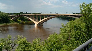
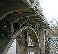
The Lake Street–Marshall Avenue Bridge is a reinforced concrete arch bridge that spans the Mississippi River between Minneapolis, Minnesota and St. Paul, Minnesota. It is oriented east-west and connects Lake Street in Minneapolis to Marshall Avenue in St. Paul. St. Paul residents often refer to it as the Marshall Avenue Bridge. The bridge was designed by Howard, Needles, Tammen, and Bergendoff.

Northern Pacific Bridge #9 is a deck truss bridge that spans the Mississippi River in Minneapolis, Minnesota, between the Seven Corners area and the University of Minnesota campus. It was built in 1924 and was designed by Frederick W. Cappelen. Railroad use of the bridge ended in 1981, and in 1999 the bridge was opened to bicycles and pedestrians. It replaced the former Northern Pacific "A Line" bridge.

Minneapolis is the largest city by population in the U.S. state of Minnesota, and the county seat of Hennepin County. The origin and growth of the city was spurred by the proximity of Fort Snelling, the first major United States military presence in the area, and by its location on Saint Anthony Falls, which provided power for sawmills and flour mills.

The Minneapolis Great Northern Depot, also known as Great Northern Station, was a passenger railroad station which served Minneapolis, Minnesota, USA. It was built in 1913 and demolished in 1978. It was located on Hennepin Avenue next to the Hennepin Avenue Bridge and across the street from the main Minneapolis Post Office.

The Eastman tunnel, also called the Hennepin Island tunnel, was a 2,000-foot-long (610 m) underground passage in Saint Anthony, Minnesota, dug beneath the Mississippi River riverbed between 1868 and 1869 to create a tailrace so water-powered business could be located upstream of Saint Anthony Falls on Nicollet Island. The tunnel ran downstream from Nicollet Island, beneath Hennepin Island, and exited below Saint Anthony Falls.

Saint Paul, Minnesota, consists of 17 officially defined city districts or neighborhoods.

Ford & Kenneth is a bus rapid transit station on the Metro A Line in Saint Paul, Minnesota.

Ford & Finn is a bus rapid transit station on the Metro A Line in Saint Paul, Minnesota.

Ford & Woodlawn is a bus rapid transit station on the Metro A Line in Saint Paul, Minnesota.

46th Street & 46th Avenue is a bus rapid transit station on the Metro A Line in Minneapolis, Minnesota.

Mississippi Gorge Regional Park is a regional park along the east and west bluffs of the Mississippi River in the cities of Minneapolis and Saint Paul in the U.S. state of Minnesota. The two-city park area is between Mississippi river miles 848 and 852, from just south of Northern Pacific Bridge Number 9 to just north of Minnehaha Regional Park, and lies within the Mississippi National River and Recreation Area. The park area protects scenic and natural areas of the Mississippi River gorge, the only true gorge along the entire length of the 2,320-mile (3,730 km) river.