Jimmy's Camp, Colorado

Last updated

Jimmy's Camp was a trading post established in 1833. [1] The site is east of present-day Colorado Springs, Colorado on the southeast side of U.S. Route 24 and east of the junction with State Highway 94. [2] Located along Trapper's Trail / Cherokee Trail, it was a rest stop for travelers and was known for its spring. Jimmy Camp was a ranch by 1870 and then a railway station on a spur of the Colorado and Southern Railway. After the ranch was owned by several individuals, it became part of the Banning Lewis Ranch. Now the land is an undeveloped park in Colorado Springs.

Contents

Fur trading and trail station

Jimmy's Camp Trail

The site was located on Jimmy's Camp Trail, along old Native American trails which became the Trapper's Trail and Cherokee Trail, which ran between the North Platte, South Platte and Arkansas Rivers. [2] [3] :63 The north-south route had two southern branches. One branch from Bent's Old Fort and another that began in Taos and Santa Fe. They met at the confluence of the Arkansas River and Fountain Creek near present-day Pueblo, then the route ran north along the banks of Fountain Creek to Jimmy Camp Creek at Fountain. [3] :63 The trail went overland through present-day Black Forest to Cherry Creek where it was followed to the South Platte River. From there, the trail forked and Trapper's Trail went to Fort Laramie and Cherokee Trail went northwest to intersect with the Oregon-California Trail. [3] :63 [4] There was another trail that ran closer through present-day Colorado Springs along the foothills. It approximates the route of Interstate 25, but the trail was not as safe as this more direct route used by many Native Americans and trappers because it was safer and not frequented by hostile Native Americans. [3] :64 Jimmy Camp Road or Jimmy Camp Trail branch of the longer Trapper's Trail / Cherokee Trail connected Fountain and Russellville. [5]

Cattle trails. The Goodnight-Loving Trail is the westernmost north-south trail to Cheyenne. Cattle-trails.jpg
Cattle trails. The Goodnight–Loving Trail is the westernmost north-south trail to Cheyenne.

Cattle was driven north along the Goodnight–Loving Trail to Cheyenne through Jimmy's Camp. [6]

Trading post, stage station and camp site

Jimmy built a cabin [2] or a crude adobe hut on lowland between Jimmy Camp Creek and a spring. [7] Trappers, Utes and other Native Americans traded furs and food (deer, buffalo, other game, and corn) for goods, guns and whiskey that Jimmy acquired from the East. [7] [8] Jimmy lit a signal fire to let Native Americans know when he returned with a new selection of goods. [1] The spot was known for its spring and a place where people and their horses could rest along the trail. [8] In addition to shade afforded by pine and cottonwood trees, there was plenty of grass for grazing around the spring. [3] :63

The first recorded trapper to use the trail past Jimmy's Camp Creek was William Sublette (1829). Kit Carson came through in 1831. [3] :64 Individuals who camped at the site included frontiersman Jim Baker, explorer John C. Frémont, [1] Rufus Sage (1842), Francis Parkman (1846), and the Mormons (1847). It was also visited by gold prospectors passing through the area during the Pike's Peak Gold Rush [2] who learned about the trail from guidebooks. [3] :65 There was stage service from Denver to Pueblo, with Jimmy's Camp and other stops in between. [9]

Namesake

Jimmy's Camp was often said to have been named after Jimmy Daugherty, who had been a member of Major Stephen Harriman Long's expedition. He was believed to have built a cabin in the 1820s or 1830s. [3] :67 [10] [11] Jimmy Camp Creek was first called Daugherty Creek. [3] :66

Authors Alice Polk Hill and L.W. Cutler state that it was named for a small Irishman Jimmy Boyer, employed by the fur trading company, who established a trading post in 1833. [1] [3] :67–68 Frank Hall states in the History of the State of Colorado and local resident Edgar Howbert and local historian John O'Byrne state that Jimmy Hayes or Hays established a trading post in 1833. [12] [7] John Steele of the Mormon Battalion of 1847 believed that Jimmy's Camp was named for Dr. Edwin James of Long's 1820 expedition. [3] :67

Jimmy's murder and marker

Native Americans came to his cabin or hut one day to find that he has been robbed and murdered. They followed tracks left by men from Mexico until they found them, and hung them from trees by their toes. They returned to Jimmy's cabin, buried him, and covered his grave with a large flat stone. [1] [3] :68–69 [7] James Beckwourth, a scout, said that he led the Native Americans who killed the Mexicans. [3] :68–69 Rufus Sage said that Jimmy was killed by a Mexican man who traveled with him and stole some calico. This occurred prior to September 1842 when Sage camped at the site. [3] :66 The crude hut crumbled away after Jimmy's death. [7]

External image
Searchtool.svg Jimmy's Camp marker

A marker was installed by the Kinnikinnik Chapter of the Daughters of the American Revolution in 1949. It says, "This tablet is the property of the State of Colorado" / "One mile southeast are the spring and site of Jimmy's Camp / Named for Jimmy (last name undetermined), an early trader who was murdered there. A famous camp site on the trail connecting the Arkansas and Platte Rivers and variously known as "Trappers' Trail, " "Cherokee Trail" and "Jimmy's Camp Trail." Site visited by Rufus Sage (1842), Francis Parkman (1846), Mormons (1847), and by many gold seekers of 1858-59." [2]

Jimmy Camp Ranch

The site, called Jimmy Camp Ranch and old Jimmy Camp mine, was purchased in 1870 by early settler Matt France, who established a ranch and raised stock there. He became a mayor of the city of Colorado Springs. [13] France and Mort Parsons built a house in 1870. [3] :72 In 1873, France raised a group of men from Colorado Springs to march out to Jimmy's Camp to meet with a group of 3,000 Cheyenne. They had been killing cattle on the ranch because "the white man has been killing our buffalo." [14] The France coal mine was established by 1885 near Jimmy's Camp. [5]

Railway

The Denver and New Orleans Railroad ran alongside Jimmy Camp Creek from Denver to Jimmy's Camp and then to Fountain and Pueblo by 1880. Between 1898 and 1913, Colorado and Southern Railway operated on the rails. [15] A half a mile east of Jimmy Camp was a railway station called Manitou Junction [16] for Denver and New Orleans Railroad [3] :66 and the Colorado and Southern Railway. [17] From there, passengers could take a nine-mile train road to Colorado Springs. [18] A post office station, called Jimmy Camp, operated between 1878 and 1879. [5]

Banning Lewis Ranch

After France, there were other people who ranched on the land, which ultimately became part of the Banning Lewis Ranch. [3] :72 It is currently an undeveloped park in Colorado Springs.

See also

Related Research Articles

<span class="mw-page-title-main">Pike's Peak Gold Rush</span> Nineteenth-century gold-prospecting frenzy in Colorado, US

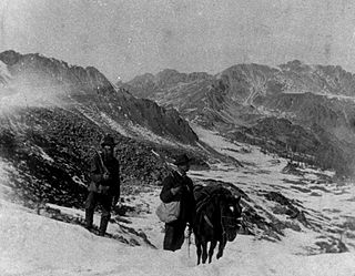
The Pike's Peak Gold Rush was the boom in gold prospecting and mining in the Pike's Peak Country of western Kansas Territory and southwestern Nebraska Territory of the United States that began in July 1858 and lasted until roughly the creation of the Colorado Territory on February 28, 1861. An estimated 100,000 gold seekers took part in one of the greatest gold rushes in North American history.

<span class="mw-page-title-main">Colorado Territory</span> Historic region of the US, 1861 to 1876

The Territory of Colorado was an organized incorporated territory of the United States that existed from February 28, 1861, until August 1, 1876, when it was admitted to the Union as the State of Colorado.

<span class="mw-page-title-main">Jim Baker (frontiersman)</span> American explorer

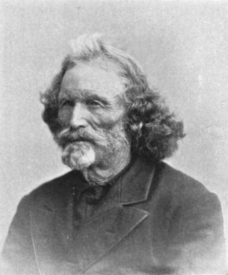
Jim Baker (1818–1898), known as "Honest Jim Baker", was a frontiersman, trapper, hunter, army scout, interpreter, and rancher. He was first a trapper and hunter. The decline of the fur trade in the early 1840s drove many trappers to quit, but Baker remained in the business until 1855. During that time he was a friend of Jim Bridger, Kit Carson and John C. Frémont. On August 21, 1841, he was among a group of twenty three trappers who were attacked by Arapaho, Cheyenne, and Sioux on what became known as Battle Mountain. After Henry Fraeb was killed, Baker organized the trappers against the Native Americans in a multiple-day fight.

<span class="mw-page-title-main">Colorado War</span> 19th-century armed conflict of the American Indian Wars

The Colorado War was an Indian War fought in 1864 and 1865 between the Southern Cheyenne, Arapaho, and allied Brulé and Oglala Sioux peoples versus the U.S. Army, Colorado militia, and white settlers in Colorado Territory and adjacent regions. The Kiowa and the Comanche played a minor role in actions that occurred in the southern part of the Territory along the Arkansas River. The Cheyenne, Arapaho, and Sioux played the major role in actions that occurred north of the Arkansas River and along the South Platte River, the Great Platte River Road, and the eastern portion of the Overland Trail. The United States government and Colorado Territory authorities participated through the 1st Colorado Cavalry Regiment, often called the Colorado volunteers. The war was centered on the Colorado Eastern Plains, extending eastward into Kansas and Nebraska.

<span class="mw-page-title-main">Montana City, Colorado</span> First settlement in what later became Denver, Colorado

Montana City was the first settlement in what was later to become Denver, Colorado. It was established during the Pikes Peak Gold Rush on the east bank of the South Platte River, just north of the confluence with Little Dry Creek, in 1858. At the time, the site was in the Kansas Territory.

<span class="mw-page-title-main">Old Colorado City</span> Place in Colorado, United States

Old Colorado City, formerly Colorado City, was once a town, but it is now a neighborhood within the city of Colorado Springs, Colorado. Its commercial district was listed on the National Register of Historic Places in 1982. It was founded during the Pikes Peak Gold Rush of 1859 and was involved in the mining industry, both as a supply hub and as a gold ore processing center beginning in the 1890s. Residents of Colorado City worked at some of the 50 coal mines of the Colorado Springs area. It was briefly the capital of the Colorado Territory. For many years, Colorado Springs prohibited the use of alcohol within its border due to the lifestyle of Colorado City's opium dens, bordellos, and saloons. It is now a tourist area, with boutiques, art galleries, and restaurants.

<span class="mw-page-title-main">History of Colorado Springs, Colorado</span> Place in Colorado, United States

Before it was founded, the site of modern-day Colorado Springs, Colorado, was part of the American frontier. Old Colorado City, built in 1859 during the Pike's Peak Gold Rush was the Colorado Territory capital. The town of Colorado Springs was founded by General William Jackson Palmer as a resort town. Old Colorado City was annexed into Colorado Springs. Railroads brought tourists and visitors to the area from other parts of the United States and abroad. The city was noted for junctions for seven railways: Denver and Rio Grande (1870), Denver and New Orleans Manitou Branch (1882), Colorado Midland (1886-1918), Colorado Springs and Interurban, Atchison, Topeka, and Santa Fe (1889), Rock Island (1889), and Colorado Springs and Cripple Creek Railways. It was also known for mining exchanges and brokers for the Cripple Creek Gold Rush.

<span class="mw-page-title-main">Great Platte River Road</span>

The Great Platte River Road was a major overland travel corridor approximately following the course of the Platte River in present-day Nebraska and Wyoming that was shared by several popular emigrant trails during the 19th century, including the Trapper's Trail, the Oregon Trail, the Mormon Trail, the California Trail, the Pony Express route, and the military road connecting Fort Leavenworth and Fort Laramie. The road, which extended nearly 370 miles (600 km) from the Second Fort Kearny to Fort Laramie, was utilized primarily from 1841 to 1866. In modern times it is often regarded as a sort of superhighway of its era, and has been referred to as "the grand corridor of America's westward expansion".

<span class="mw-page-title-main">Trapper's Trail</span> Historical trail or road

The Trapper's Trail or Trappers' Trail is a north-south path along the eastern base of the Rocky Mountains that links the Great Platte River Road at Fort Laramie and the Santa Fe Trail at Bent's Old Fort. Along this path there were a number of trading posts, also called trading forts.

The Overland Trail was a stagecoach and wagon trail in the American West during the 19th century. While portions of the route had been used by explorers and trappers since the 1820s, the Overland Trail was most heavily used in the 1860s as a route alternative to the Oregon, California, and Mormon trails through central Wyoming. The Overland Trail was famously used by the Overland Stage Company owned by Ben Holladay to run mail and passengers to Salt Lake City, Utah, via stagecoaches in the early 1860s. Starting from Atchison, Kansas, the trail descended into Colorado before looping back up to southern Wyoming and rejoining the Oregon Trail at Fort Bridger. The stage line operated until 1869 when the completion of the First transcontinental railroad eliminated the need for mail service via stagecoach.

<span class="mw-page-title-main">South Platte Trail</span>

South Platte Trail was a historic trail that followed the southern side of South Platte River from Fort Kearny in Nebraska to Denver, Colorado. Plains Indians, such as the Cheyenne and the Arapaho, hunted in the lands around the South Platte River. They also traded at trading posts along the route, as did white travelers. Travelers included trappers, traders, explorers, the military, and those following the gold rush. The trail was also used by the Pony Express.

<span class="mw-page-title-main">Bear Creek (Colorado)</span> River

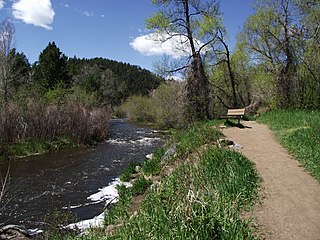
Bear Creek is a tributary of the South Platte River in central Colorado in the United States. It begins as a small creek up in the Mount Evans Wilderness in Summit Lake and makes its way through Evergreen, CO, Kittredge, CO, Idledale, CO and Morrison, CO before entering into Bear Ponds. The stream flows to a confluence with the South Platte River in Sheridan, Colorado, just south of Denver, and then into the South Platte River near Englewood. As it moves downstream, Kerr Gulch, Cold Spring Gulch and Saw Mill Gulch all add to its flow making it a sustainable river to fish from spring to fall, with close access to the Denver area.

St. Peter's Dome is a granite-topped peak on Pikes Peak massif in the Pike National Forest. The peak, at 9,528 feet (2,904 m) in elevation, is located in El Paso County, Colorado, above Colorado Springs. It is located about 8 miles (13 km) from Colorado Springs along Old Stage and Gold Camp Roads. Old Stage Road is picked up behind The Broadmoor and Gold Camp Road winds through Cheyenne Canyon.

<span class="mw-page-title-main">Cheyenne Mountain</span> Mountain in El Paso County, Colorado, US

Cheyenne Mountain is a triple-peaked mountain in El Paso County, Colorado, southwest of downtown Colorado Springs. The mountain serves as a host for military, communications, recreational, and residential functions. The underground operations center for the North American Aerospace Defense Command (NORAD) was built during the Cold War to monitor North American airspace for missile launches and Soviet military aircraft. Built deep within granite, it was designed to withstand the impact and fallout from a nuclear bomb. Its function broadened with the end of the Cold War, and then many of its functions were transferred to Peterson Air Force Base in 2006.

History of Rocky Mountain National Park began when Paleo-Indians traveled along what is now Trail Ridge Road to hunt and forage for food. Ute and Arapaho people subsequently hunted and camped in the area. In 1820, the Long Expedition, led by Stephen H. Long for whom Longs Peak was named, approached the Rockies via the Platte River. Settlers began arriving in the mid-1800s, displacing the Native Americans who mostly left the area voluntarily by 1860, while others were removed to reservations by 1878.

<span class="mw-page-title-main">Fort Wicked</span> Civilian fort in Colorado, United States

Fort Wicked was a ranch and stage station on the Overland Trail from 1864 to 1868 in present-day Merino, Colorado. A historical marker commemorating the ranch is located at US 6 and CR-2.5. The ranch itself was located near a ford of the South Platte River, near where US-6 now crosses over the river. Fort Wicked was one of the few places along the trail to Denver that withstood an attack by Lakota, Cheyenne, and Arapaho Native Americans in the Colorado War of 1864. It was named Fort Wicked for the "bitter defence" made by Holon Godfrey, his family, and his employees.

<span class="mw-page-title-main">John and Elizabeth Tallman</span> Early settlers of Colorado in 1866

John and Elizabeth Tallman settled in Pine Grove of Colorado Territory, present-day Parker, Colorado, in 1866. They were among the early settlers in Douglas County, Colorado, with John working as a cattle rancher, sawmill hand, county clerk, and businessman. John and Elizabeth ran the Elizabeth Hotel in the late 1890s. She also wrote of her experiences with Native Americans and observations of warfare among the Cheyenne, Arapaho, and the Utes.

<span class="mw-page-title-main">Edgerton, Colorado</span>

Edgerton is an extinct town at the confluence of Monument Creek and West Monument Creek eight miles north of present-day Colorado Springs in El Paso County, Colorado, United States. and. It was across from Black Forest. The Edgerton post office operated from June 16, 1870, until August 28, 1902.

<span class="mw-page-title-main">Friday (Arapaho chief)</span> Chief and interpreter of Northern Arapaho

Friday (Arapaho: Teenokuhu or Warshinun, also known as Friday Fitzpatrick, was an Arapaho leader and interpreter in the mid to late 1800s. When he was around the age of eight, he was separated from his band and was taken in by a white trapper. During the next seven years, he was schooled in St. Louis, Missouri and went on trapping expeditions with his informally adopted father, Thomas Fitzpatrick. After he was recognized by his mother during an encounter with the Arapaho, he returned to the tribe.

Margaret Poisal was "the only woman who was an official witness, interpreter, and consultant at many meetings and treaty councils held along or in close proximity to the Santa Fe Trail." The daughter of French Canadian trapper John Poisal and Arapaho Snake Woman, Poisal was educated at a convent school. She married Thomas Fitzpatrick, an Indian agent, and they worked together negotiating peace between Native American tribes and the United States government. After Fitzpatrick died, Poisal continued to work as an interpreter and peacemaker.

References

  1. 1 2 3 4 5 Alice Polk Hill (1884). Tales of the Colorado Pioneers. Pierson & Gardner. pp.  316–318.
  2. 1 2 3 4 5 "Tales Told with Markers" (PDF). Colorado Magazine. Summer 1970. p. 197. Archived from the original (PDF) on June 12, 2018. Retrieved July 18, 2018.
  3. 1 2 3 4 5 6 7 8 9 10 11 12 13 14 15 16 17 Dorothy Price Shaw (January 1950). "Jimmy's Camp on the Cherokee Trail" (PDF). Colorado Magazine. Vol. 27, no. 1.
  4. William Y. Chalfant (October 1, 2002). Cheyennes and Horse Soldiers: The 1857 Expedition and the Battle of Solomon's Fork. University of Oklahoma Press. p. 21. ISBN   978-0-8061-3500-7.
  5. 1 2 3 "Place Names of Colorado" (PDF). Denver Public Library. pp. 237, 331. Retrieved July 19, 2018.
  6. Angela Thaden Hahn (2012). Fountain. Arcadia Publishing. p. 9. ISBN   978-0-7385-9503-0.
  7. 1 2 3 4 5 "How Indians Took Revenge and Hanged 11 Mexicans for Killing Jimmy Hays, Who Established Jimmy's Camp East of Colorado Springs" (PDF). Gazette. June 26, 1932. p. 3:3–5. Retrieved July 19, 2018.
  8. 1 2 Leroy R. Hafen (2004). To the Pike's Peak Gold Fields, 1859. University of Nebraska Press. p. 50. ISBN   0-8032-7341-X.
  9. Fort Carson Grow the Army Stationing Decisions: Environmental Impact Statement. 2009. pp. 1987–1988.
  10. Ray Shaffer (1978). A Guide to Places on the Colorado Prairie, 1540-1975. Pruett Publishing Company. p. 137. ISBN   978-0-87108-513-9.
  11. William Y. Chalfant (October 1, 2002). Cheyennes and Horse Soldiers: The 1857 Expedition and the Battle of Solomon's Fork. University of Oklahoma Press. p. 99. ISBN   978-0-8061-3500-7.
  12. Leroy R. Hafen (2004). To the Pike's Peak Gold Fields, 1859. University of Nebraska Press. p. 230. ISBN   0-8032-7341-X.
  13. McGrath, Maria Davies (1934). The Real Pioneers of Colorado (PDF). The Denver Museum. pp. 143–145. Retrieved July 18, 2018.
  14. Quiett, Glenn Chesney (1934). "The Built the West". D. Appleton-Century Company. Retrieved July 19, 2018.
  15. Angela Thaden Hahn (2012). Fountain. Arcadia Publishing. p. 51. ISBN   978-0-7385-9503-0.
  16. George A. Crofutt (1885). Crofutt's Grip-sack Guide of Colorado: A Complete Encyclopedia of the State ... Overland Publishing Company. p. 109.
  17. Henry Gannett (1906). A Gazetteer of Colorado. U.S. Government Printing Office. p.  94.
  18. State Historical and Natural History Society of Colorado (1927). "History of Colorado". Linderman Co., Inc. Retrieved July 19, 2018.

Further reading

38°51′10.17″N104°39′55.57″W / 38.8528250°N 104.6654361°W / 38.8528250; -104.6654361