Related Research Articles

James Ross Island is a large island off the southeast side and near the northeastern extremity of the Antarctic Peninsula, from which it is separated by Prince Gustav Channel. Rising to 1,630 metres (5,350 ft), it is irregularly shaped and extends 64 km in a north–south direction. It was charted in October 1903 by the Swedish Antarctic Expedition under Otto Nordenskiöld, who named it for Sir James Clark Ross, the leader of a British expedition to this area in 1842 that discovered and roughly charted a number of points along the eastern side of the island. The style, "James" Ross Island is used to avoid confusion with the more widely known Ross Island in McMurdo Sound.


Prince Olav Harbour is a small harbour in the south west portion of Cook Bay, entered between Point Abrahamsen and Sheep Point, along the north coast of South Georgia.
Mount Normann is a mountain, 1,240 m (4061 ft), standing 1 mile (1.6 km) north of Smaaland Cove at the south end of South Georgia. The feature has appeared on charts since the 1930s. It was surveyed by the SGS in the period 1951–57, and named by the United Kingdom Antarctic Place-Names Committee (UK-APC) for Wilhelm Normann (1870-1939), German chemist, whose work led to the introduction in about 1907 of the hydrogenation process for hardening whale oil.
Hound Bay is a bay at the base of Barff Peninsula. It is 2.5 miles (4 km) wide at its mouth and recedes 3 miles (5 km), entered between Tijuca Point and Cape Vakop along the north coast of South Georgia. The names "George Bay" and "Hundebugten" have appeared on charts for this feature. The South Georgia Survey (SGS) of 1951–52 reported that this bay was better known to whalers and sealers as "Bikjebugten". The name Hound Bay, proposed by the UK Antarctic Place-Names Committee (UK-APC) is an English form of this name.
Barff Peninsula is a peninsula forming the east margin of Cumberland East Bay, South Georgia Island. It is 8 miles (13 km) long and extends northwest from Sörling Valley to Barff Point, its farthest extremity. It was probably first seen by the British expedition under James Cook in 1775. The peninsula as a whole takes its name from Barff Point, which was named for Royal Navy Lieutenant A.D. Barff of HMS Sappho, who, assisted by Captain C.A. Larsen, sketched a map of Cumberland Bay in 1906. Barff Point is considered the eastern headland of East Cumberland Bay.
You may be looking for Undine South Harbour near Ducloz Head, South Georgia
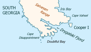
Drygalski Fjord is a bay 1 mile (1.6 km) wide which recedes northwestwards 7 miles (11 km), entered immediately north of Nattriss Head along the southeast coast of South Georgia. It was charted by the Second German Antarctic Expedition, 1911–12, under Wilhelm Filchner, and named for Professor Erich von Drygalski, the leader of the First German Antarctica Expedition, 1901–03.
The Samuel Islands are a group of small islands and rocks lying close to the south coast of South Georgia, 1.6 km west-southwest of Nilse Hullet and 3.2 km east-southeast of Klutschak Point. Surveyed by the SGS in the period 1951–57. Named by the United Kingdom Antarctic Place-Names Committee (UK-APC) after the catcher Don Samuel, built in 1925 and later owned by the Compania Argentina de Pesca, Grytviken, which sank in the vicinity of these islands in 1951.

The Bay of Isles is a bay 9 miles (14 km) wide and receding 3 miles (5 km), lying between Cape Buller and Cape Wilson along the north coast of South Georgia. It was discovered in 1775 by a British expedition under James Cook and so named by him because numerous islands lie in the bay. Of South Georgia's 31 breeding bird species, 17 are found here.
Jason Harbour is a bay 1 mile (1.6 km) wide, lying west of Allen Bay in the north side of Cumberland West Bay, South Georgia. It was charted and named by the Swedish Antarctic Expedition, 1901–04, under Otto Nordenskiöld. The bay was previously visited by the Jason, Captain C.A. Larsen, in 1894.
The Andrews Rocks are a small group of rocks 0.5 nautical miles (1 km) east of Cape Paryadin, South Georgia. The rocks are bare of vegetation and awash in heavy seas. The name "Andrews Islands" was probably given by Lieutenant Commander J.M. Chaplin, Royal Navy, of the RRS Discovery during his survey of the area in 1926. The South Georgia Survey, 1955–56, reported that "rocks" is a more suitable descriptive term for this group.
Blue Whale Harbour is a small, sheltered anchorage entered 1 nautical mile (2 km) west-southwest of Cape Constance, along the north coast of South Georgia Island. It was charted in 1930 by Discovery Investigations personnel, along with its constituent features. It is named for the blue whale, a commercially important species which was once widely distributed in polar and subpolar waters; numbers are now very small.
Olsen Rock is a rock lying 0.5 nautical miles (0.9 km) southeast of Cape Paryadin, off the west end of South Georgia. Charted by DI personnel in 1926–27. Surveyed by the SGS in the period 1951–57, and named by the United Kingdom Antarctic Place-Names Committee (UK-APC) for Soren Olsen, gunner of the South Georgia Whaling Co. at Leith Harbor, 1926–30, 1933–39 and 1945–53.
Jordan Cove is a small cove which is the principal indentation in the south side of Bird Island, off the west end of South Georgia, near Antarctica.
Molly Hill is a hill between Evermann Cove and Johnson Cove on western Bird Island, South Georgia, an island in the southern Atlantic Ocean. The name derives from the black-browed albatross or "mollymawk" which breeds on the hill in large numbers. According to the UK Antarctic Place-Names Committee, the name has been in local usage since at least 1963.
Freshwater Inlet is the small eastern arm of Jordan Cove on the south side of Bird Island, South Georgia, with Wanderer Valley to the southwest. It was charted by the South Georgia Survey in the period 1951–57 and was named in 1956 by W.N. Bonner, a British government biologist and sealing inspector, because the feature is fed by freshwater streams.
Gazella Peak is a peak rising over 120 metres (390 ft) between Roche Peak and the Cordall Stacks on the north side of Bird Island, South Georgia. It was charted by the South Georgia Survey in the period 1951–57, and was named by the UK Antarctic Place-Names Committee in 1963 after the species name of the Antarctic fur seal, which breeds in considerable numbers on Bird Island.
Hauge Reef is a chain of islands and rocks extending in an east-northeast direction from the eastern extremity of Annenkov Island to a point about 3 nautical miles (6 km) west-southwest of Cape Darnley, South Georgia. It was first charted in 1819 by a Russian expedition under Fabian Gottlieb von Bellingshausen. The reef was surveyed by the South Georgia Survey (SGS), 1951–52, and named for Captain Ole Hauge, of the sealer Albatros, whose knowledge of the coasts of South Georgia was of great assistance to the SGS.
Tornquist Bay is a small bay between Cape Constance and Antarctic Point along the north coast of South Georgia. Charted in 1929-30 by DI personnel, who called it Windy Cove, because of strong gusts of wind experienced there, but the name Windy Hole was subsequently used on charts for the bay. Following a survey of South Georgia in 1951–52, the SGS reported that this feature is known to the whalers and sealers as Tornquist Bay, because the wreck of the Cape Constance on October 16, 1950, lies near its west shore. This latter name is approved on the basis of local usage; the name Windy Hole is never used locally. The name Windy Cove, originally applied to this bay, has been transferred in local usage to the bay immediately southeast of Antarctic Point and it has since become established there.
References
- ↑ "Jomfruene". Geographic Names Information System . United States Geological Survey, United States Department of the Interior . Retrieved 5 April 2013.
![]() This article incorporates public domain material from "Jomfruene". Geographic Names Information System . United States Geological Survey.
This article incorporates public domain material from "Jomfruene". Geographic Names Information System . United States Geological Survey.
Capital: King Edward Point | |||||||
| General | |||||||
| Settlements / Whaling stations | |||||||
| South Georgia islands | |||||||
| South Sandwich Islands |
| ||||||
| Seamounts | |||||||
| Landmarks |
| ||||||
| | This South Georgia and the South Sandwich Islands location article is a stub. You can help Wikipedia by expanding it. |