
Francis Scott Key was an American lawyer, author, and amateur poet from Frederick, Maryland, best known as the author of the text of the U.S. national anthem, "The Star-Spangled Banner". Key observed the British bombardment of Fort McHenry in 1814 during the War of 1812. He was inspired upon seeing the American flag still flying over the fort at dawn and wrote the poem "Defence of Fort M'Henry"; it was published within a week with the suggested tune of the popular song "To Anacreon in Heaven". The song with Key's lyrics became known as "The Star-Spangled Banner" and slowly gained in popularity as an unofficial anthem, finally achieving official status more than a century later under President Herbert Hoover as the national anthem.

Thurmont is a town in Frederick County, Maryland, United States. The population was 6,935 at the 2020 census. The town is located in the northern part of Frederick County, approximately ten miles from the Pennsylvania border, along U.S. Highway 15. It is very close to Cunningham Falls State Park and Catoctin Mountain Park, the latter of which contains the presidential retreat of Camp David. Thurmont is also home to Catoctin Colorfest, an arts and crafts festival that draws in about 125,000 people each autumn.

Clay Township is a civil township of St. Clair County in the U.S. state of Michigan. The population was 9,066 at the 2010 Census.

Ashton is an unincorporated community in Montgomery County, Maryland, United States. The commercial center of Ashton lies at the junction of Route 108 and New Hampshire Avenue. The etymology of Ashton is unclear, as some longtime residents claim that it comes from reference to a large ash tree that stood at the junction of routes 108 and 650. Others have stated that it is a portmanteau of the names of two Thomas family homes, Ashland and Clifton, each located one mile from the junction.

Woodley Park is a neighborhood in Northwest, Washington, DC. It is bounded on the north by Woodley Road and Klingle Road, on the east by the National Zoo and Rock Creek Park, on the south by Calvert Street, on the southwest by Cleveland Avenue, and on the west by 34th Street.

Maryland Route 194 (MD 194) is a state highway in the U.S. state of Maryland. The state highway runs 23.87 miles (38.42 km) from MD 26 in Ceresville north to the Pennsylvania state line near Taneytown, where the highway continues as Pennsylvania Route 194 (PA 194) toward Hanover. MD 194 is the main highway between Frederick and Hanover; the state highway connects the towns of Walkersville and Woodsboro in northeastern Frederick County with Keymar and Taneytown in northwestern Carroll County. MD 194 was blazed as a migration route in the 18th century and a pair of turnpikes in Frederick County in the 19th century, one of which was the last private toll road in Maryland. The state highway, which was originally designated MD 71, was built as a modern highway in Frederick County in the mid-1920s and constructed as Francis Scott Key Highway in Carroll County in the late 1920s and early 1930s. MD 194 received its modern route number in 1956 as part of a three-route number swap. The state highway's bypasses of Walkersville and Woodsboro opened in the early 1980s and mid-1990s, respectively.
South Bloomingville is an unincorporated community in western Benton Township, Hocking County, Ohio, United States. Although it is unincorporated, it has a zip code of 43152. It is located at the intersection of State Routes 56 and 664, slightly west of Hocking Hills State Park. Early settlers and brief history can be found in the History of Hocking County. A more complete history with photos is found in the genealogy site of Rootsweb. In 1880 Bloomingville had a population of 165. In the histories there are references to Bloomingville and South Bloomville, the location and distinction is still being discovered.

The Stormont Estate is an estate east of Belfast in County Down, Northern Ireland. It is the site of Northern Ireland's main Parliament Buildings, which is surrounded by woods and parkland, and is often referred in contemporary media as the metonym "Stormont".

Van Lear is an unincorporated community in Washington County, Maryland, United States. The community is part of the Hagerstown-Martinsburg, MD-WV MSA. Van Lear is located between Halfway and Williamsport.

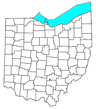
Maryland Route 77 is a state highway in the U.S. state of Maryland. The state highway runs 20.74 miles (33.38 km) from MD 64 in Smithsburg east to MD 194 in Keymar. MD 77 is the main east–west highway of northern Frederick County. The state highway connects Thurmont with eastern Washington County via Foxville, which lies between South Mountain and Catoctin Mountain near Catoctin Mountain Park and Cunningham Falls State Park. MD 77 links Thurmont with western Carroll County through the communities of Graceham, Rocky Ridge, and Detour in the Monocacy River valley. MD 77 was constructed from Thurmont east to Detour in the 1920s and early 1930s. A disjoint section of MD 77 was built between Cavetown and Foxville in the late 1930s. The portions of the modern highway between Foxville and Thurmont and from Detour to Keymar were county highways until they were designated part of MD 77 in 1956. MD 77's western terminus was moved east to MD 64 in Smithsburg in 1960.
The Holliday Street Theater also known as the New Theatre, New Holliday, Old Holliday, The Baltimore Theatre, and Old Drury, was a historical theatrical venue in Federal Period Baltimore, Maryland. It is known for showing the first performance of Francis Scott Key's "The Star-Spangled Banner".
Comus is an unincorporated community in Montgomery County, Maryland, United States. Its elevation is 591 feet (180 m). The chiefly rural community is located approximately 39.7 miles (63.9 km) by car from Washington D.C.
Dawsonville is an unincorporated community in Montgomery County, Maryland, United States.
Linwood is an unincorporated community in Carroll County, Maryland, United States. The community is home to the Linwood Historic District, which was added to the National Register of Historic Places in 1980.
Sherwood Forest is an unincorporated community in Montgomery County, Maryland, United States. It is roughly bounded by Randolph Road, Sherwood Forest Drive, Notley Road, the Intercounty Connector, and Northwest Branch Park.
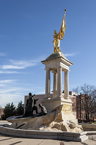
The Francis Scott Key Monument is an outdoor sculpture to Francis Scott Key in Baltimore, Maryland.

Norwood is an unincorporated community in Montgomery County, Maryland, United States, located at the intersection of Layhill Road, Norwood Road, and Ednor Road, two miles from the Intercounty Connector (ICC).
Jesa Farm Dairy Limited, often referred to as Jesa Farm Dairy, is a dairy processing company in Uganda.
Roselle is an unincorporated community in northwest Madison County, in the U.S. state of Missouri.
Yates is an unincorporated community in Randolph County, in the U.S. state of Missouri.


