Union Bridge, Maryland

Last updated

Union Bridge, Maryland
Main St in Union Bridge.jpg
Main Street in 2019
Flag of Union Bridge, Maryland.png
Seal of Union Bridge, Maryland.png
Carroll County Maryland Incorporated and Unincorporated areas Union Bridge Highlighted.svg
Coordinates: 39°34′7″N77°10′39″W / 39.56861°N 77.17750°W / 39.56861; -77.17750
Country United States
State Maryland
County Carroll
Incorporated 1872 [1]
Government
   Mayor Perry Jones (R)
Area
[2]
  Total1.04 sq mi (2.68 km2)
  Land1.03 sq mi (2.67 km2)
  Water0.01 sq mi (0.02 km2)
Elevation
456 ft (139 m)
Population
 (2020)
  Total936
  Density909.62/sq mi (351.05/km2)
Time zone UTC-5 (Eastern (EST))
  Summer (DST) UTC-4 (EDT)
ZIP code
21791
Area code(s) 410,443,667
FIPS code 24-79350
GNIS feature ID0591452
Website townofub.org

Union Bridge is a town in Carroll County, Maryland, United States. The population was 936 at the 2020 census. [3]

Contents

Much of the town was added to the National Register of Historic Places as the Union Bridge Historic District in 1994. [4]

Geography

Union Bridge is located at 39°34′7″N77°10′39″W / 39.56861°N 77.17750°W / 39.56861; -77.17750 (39.568550, -77.177618). [5]

According to the United States Census Bureau, the town has a total area of 1.05 square miles (2.72 km2), of which 1.04 square miles (2.69 km2) is land and 0.01 square miles (0.03 km2) is water. [6]

MD 75 heading northeast out of Union Bridge 2016-08-20 18 21 16 View north along Maryland State Route 75 (Green Valley Road) at Main Street in Union Bridge, Carroll County, Maryland.jpg
MD 75 heading northeast out of Union Bridge
Birds-eye view of Union Bridge Union Bridge MD.JPG
Birds-eye view of Union Bridge

Transportation

The primary method of travel to and from Union Bridge is by road. The only primary highway serving the town is Maryland Route 75, which follows Green Valley Road and Main Street through Union Bridge. From Union Bridge, MD 75 connects southward to Libertytown and New Market, and turns eastward to New Windsor.

Demographics

Historical population
CensusPop.Note
1870 323
1880 57076.5%
1890 74330.4%
1900 663−10.8%
1910 80421.3%
1920 1,08234.6%
1930 862−20.3%
1940 831−3.6%
1950 8401.1%
1960 833−0.8%
1970 9048.5%
1980 9272.5%
1990 910−1.8%
2000 9898.7%
2010 975−1.4%
2020 936−4.0%
U.S. Decennial Census [7]

2010 census

As of the census [8] of 2010, there were 975 people, 394 households, and 251 families living in the town. The population density was 937.5 inhabitants per square mile (362.0/km2). There were 429 housing units at an average density of 412.5 per square mile (159.3/km2). The racial makeup of the town was 91.7% White, 5.1% African American, 0.3% Native American, 0.7% from other races, and 2.2% from two or more races. Hispanic or Latino of any race were 1.4% of the population.

There were 394 households, of which 34.0% had children under the age of 18 living with them, 44.2% were married couples living together, 13.2% had a female householder with no husband present, 6.3% had a male householder with no wife present, and 36.3% were non-families. 29.7% of all households were made up of individuals, and 14.7% had someone living alone who was 65 years of age or older. The average household size was 2.47 and the average family size was 3.06.

The median age in the town was 39.2 years. 23.9% of residents were under the age of 18; 10.6% were between the ages of 18 and 24; 24.3% were from 25 to 44; 26.2% were from 45 to 64; and 15.1% were 65 years of age or older. The gender makeup of the town was 48.6% male and 51.4% female.

2000 census

As of the census [9] of 2000, there were 989 people, 372 households, and 265 families living in the town. The population density was 1,163.1 inhabitants per square mile (449.1/km2). There were 409 housing units at an average density of 481.0 per square mile (185.7/km2). The racial makeup of the town was 92.82% White, 5.56% African American, 0.40% Native American, 0.10% Asian, and 1.11% from two or more races. Hispanic or Latino of any race were 0.51% of the population.

There were 372 households, out of which 36.8% had children under the age of 18 living with them, 53.0% were married couples living together, 13.2% had a female householder with no husband present, and 28.5% were non-families. 22.8% of all households were made up of individuals, and 7.8% had someone living alone who was 65 years of age or older. The average household size was 2.66 and the average family size was 3.11.

In the town, the population was spread out, with 28.9% under the age of 18, 6.3% from 18 to 24, 30.3% from 25 to 44, 21.3% from 45 to 64, and 13.1% who were 65 years of age or older. The median age was 36 years. For every 100 females, there were 96.6 males. For every 100 females age 18 and over, there were 92.1 males.

The median income for a household in the town was $36,250, and the median income for a family was $37,500. Males had a median income of $31,563 versus $20,083 for females. The per capita income for the town was $17,827. About 10.6% of families and 13.7% of the population were below the poverty line, including 21.8% of those under age 18 and 5.7% of those age 65 or over.

Notable people

See also

Related Research Articles

<span class="mw-page-title-main">Tonsina, Alaska</span> CDP in Alaska, United States

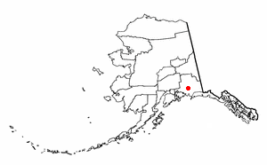
Tonsina is a census-designated place (CDP) in Copper River Census Area, Alaska, United States. At the 2020 census the population was 55, down from 78 in 2010.

Stetson is a town in Penobscot County, Maine, United States. The population was 1,186 at the 2020 census. It was named after its first proprietor, Amasa Stetson. His brother Simeon Stetson originally settled here as well, but moved to nearby Hampden in 1803. Simeon's sons Charles, George, and Isaiah founded a powerful mercantile and political family in Bangor.

<span class="mw-page-title-main">New Portland, Maine</span> Town in the state of Maine, United States

New Portland is a town in Somerset County, Maine, United States. It is perhaps best known for its Wire Bridge, a cable suspension bridge completed in 1866 that is the last remaining bridge of its type in Maine, and possibly the U.S. Much of North New Portland's Main Street burned to the ground in the fire of 1919, including a hotel. The annual town fair draws large crowds from around, and is held in September. The population was 765 at the 2020 census. The town was given to the residents of Falmouth by the Massachusetts legislature to repay them for their loss when the British fleet burned Falmouth in 1775.

Beals is a town in Washington County, Maine, United States, located on an island opposite Jonesport. The town was named after Manwarren Beal, an early settler. The population was 443 at the 2020 census.

<span class="mw-page-title-main">Goldsboro, Maryland</span> Town in Maryland

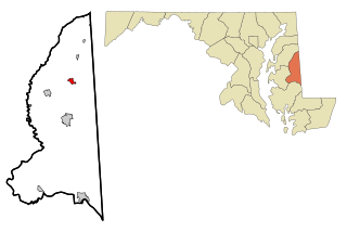
Goldsboro is a town in Caroline County, Maryland, United States. William James Yeager is the current mayor. The population was 246 at the 2010 United States Census. The zip code is 21636. First known as Oldtown, it was renamed in 1870 for the prominent Goldsborough family who owned land in the area. Castle Hall was listed on the National Register of Historic Places in 1975.

<span class="mw-page-title-main">Greensboro, Maryland</span> Town in Maryland

Greensboro is a town located on the banks of the Choptank River in Caroline County, Maryland, United States. The population was 1,931 at the 2010 United States Census. The ZIP code is 21639. The primary phone exchange is 482 and the area code is 410. The town is served by Maryland Routes 480 and 313.

<span class="mw-page-title-main">Hillsboro, Maryland</span> Town in Maryland

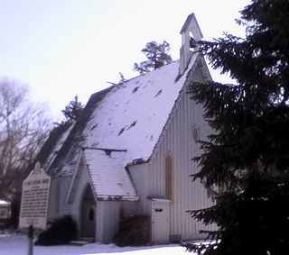
Hillsboro is a town in Caroline County, Maryland, United States. The population was 161 at the 2010 United States Census. Daffin House and St. Paul's Episcopal Church were listed on the National Register of Historic Places in 1975.

<span class="mw-page-title-main">Charlestown, Maryland</span> Town in Maryland, United States

Charlestown is a town in Cecil County, Maryland, United States. The population was 1,183 at the 2010 census.

<span class="mw-page-title-main">Chesapeake City, Maryland</span> Town in Maryland, United States

Chesapeake City is a town in Cecil County, Maryland, United States. The population was 736 at the 2020 census.

<span class="mw-page-title-main">Eldorado, Maryland</span> Town in Maryland, United States

EldoradoEL-də-RAY-doh is a town in Dorchester County, Maryland, United States. The population was 45 at the 2020 census, making it the second smallest town in Maryland.

<span class="mw-page-title-main">Princess Anne, Maryland</span> Town in Maryland, United States

Princess Anne is a town in Somerset County, Maryland, United States, that also serves as its county seat. Its population was 3,290 at the 2010 census. It is included in the Salisbury, Maryland–Delaware Metropolitan Statistical Area. It is home to the University of Maryland Eastern Shore and the Teackle Mansion.

<span class="mw-page-title-main">Mardela Springs, Maryland</span> Town in Maryland, United States

Mardela Springs is a town in Wicomico County, Maryland, United States. The population was 357 at the 2010 census. It is included in the Salisbury, Maryland-Delaware Metropolitan Statistical Area.

<span class="mw-page-title-main">Littlestown, Pennsylvania</span> Borough in Pennsylvania, United States

Littlestown is a borough in Adams County, Pennsylvania, United States. The population was 4,782 at the 2020 census.

<span class="mw-page-title-main">Peach Bottom Township, Pennsylvania</span> Township in Pennsylvania, United States

Peach Bottom Township is a township in York County, Pennsylvania, 60 miles (97 km) south of Harrisburg. The population was 4,961 at the 2020 census.

<span class="mw-page-title-main">Shrewsbury Township, York County, Pennsylvania</span> Township in Pennsylvania, United States

Shrewsbury Township is a township in York County, Pennsylvania, United States. The population was 6,651 at the 2020 census.

<span class="mw-page-title-main">Belington, West Virginia</span> City in West Virginia

Belington is a town in Barbour County, West Virginia, United States, situated along the Tygart Valley River. The population was 1,804 as of the 2020 census.

<span class="mw-page-title-main">Meadow Bridge, West Virginia</span> Town in West Virginia, United States

Meadow Bridge is a town in Fayette County, West Virginia, United States. The population was 379 at the 2010 census. The first settler of the area was John Gwin, closely followed by Dan Griffin.

<span class="mw-page-title-main">Marcellon, Wisconsin</span> Town in Wisconsin, United States

Marcellon is a town in Columbia County, Wisconsin, United States. The population was 1,024 at the 2000 census. The unincorporated community of Belle Fountain is located in the town.

<span class="mw-page-title-main">Lamartine, Wisconsin</span> Town in Wisconsin, United States

Lamartine is a town in Fond du Lac County, Wisconsin, United States. The population was 1,616 at the 2000 census. The unincorporated communities of Lamartine, Rogersville, and Woodhull are located in the town.

<span class="mw-page-title-main">Smithers, West Virginia</span> Place in West Virginia, United States

Smithers is a city in Fayette and Kanawha counties in the U.S. state of West Virginia. Located along the Kanawha River, it lies almost entirely in Fayette County. The population was 751 at the 2020 census. The city most likely takes its name from Smithers Creek. The small river city is noted for having a rich cultural history related to both its coal mining and Italian-American heritages.

References

  1. "Union Bridge". Maryland Manual. State of Maryland. Retrieved June 25, 2017.
  2. "2020 U.S. Gazetteer Files". United States Census Bureau. Retrieved April 26, 2022.
  3. "Profile of General Population and Housing Characteristics: 2020 Demographic Profile Data (DP-1): Union Bridge town, Maryland". United States Census Bureau . Retrieved May 1, 2022.
  4. "National Register Information System". National Register of Historic Places . National Park Service. April 15, 2008.
  5. "US Gazetteer files: 2010, 2000, and 1990". United States Census Bureau. February 12, 2011. Retrieved April 23, 2011.
  6. "US Gazetteer files 2010". United States Census Bureau. Archived from the original on January 25, 2012. Retrieved January 25, 2013.
  7. "Census of Population and Housing". Census.gov. Retrieved June 4, 2015.
  8. "U.S. Census website". United States Census Bureau . Retrieved January 25, 2013.
  9. "U.S. Census website". United States Census Bureau . Retrieved January 31, 2008.