Baltimore County is the third-most populous county located in the U.S. state of Maryland and is part of the Baltimore metropolitan area and Baltimore-Washington metropolitan area. Baltimore County is part of the Northeast megalopolis, which stretches from Virginia northward to Boston. Baltimore County hosts a diversified economy, with particular emphasis on education, government, and health care.

Carroll County is a county located in the U.S. state of Maryland. As of the 2010 census, the population was 167,134. Its county seat is Westminster.

Owings Mills is an unincorporated community and census-designated place in Baltimore County, Maryland, United States. It is a suburb of Baltimore. The population was 30,622 at the 2010 census. Owings Mills is home to the northern terminus of the Baltimore Metro Subway, and housed the Owings Mills Mall until its closure in 2015. It is also home to the Baltimore Ravens' headquarters facility. In 2008, CNNMoney.com named Owings Mills number 49 of the "100 Best Places to Live and Launch".

Pikesville is a census-designated place (CDP) in Baltimore County, Maryland, United States. Pikesville is just northwest of the Baltimore city limits. It is the northwestern suburb closest to Baltimore.

Randallstown is an unincorporated community and census-designated place in Baltimore County, Maryland, United States. It is named after Christopher and Thomas Randall, two 18th-century tavern-keepers. At that time, Randallstown was a tollgate crossroads on the Liberty Turnpike, a major east–west thoroughfare. Today it is a suburb of Baltimore, with a population of 32,430 as of the 2010 census. In the 1990s, Randallstown transitioned to a majority African American community, and is currently notable for its broad ethnic diversity.

Eldersburg is an unincorporated community and census-designated place (CDP) in Carroll County, Maryland, United States. The population was 30,531 at the 2010 census.
Sykesville is a small town in Carroll County, Maryland, United States. The town lies 20 miles (32 km) west of Baltimore and 40 miles (64 km) north of Washington D.C. The population was 4,436 at the 2010 census. BudgetTravel.com named Sykesville 'Coolest Small Town in America' in June 2016.

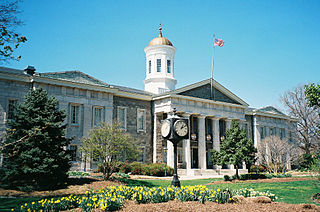
Westminster is a city in northern Maryland, United States. A suburb of Baltimore, it is the seat of Carroll County. The city's population was 18,590 at the 2010 census. Westminster is an outlying community within the Baltimore-Towson, MD MSA, which is part of a greater Washington-Baltimore-Northern Virginia, DC-MD-VA-WV CSA.

Hampstead is a town in Carroll County in the U.S. state of Maryland. The population was 6,323 at the 2010 census.

The Baltimore–Washington metropolitan area is a combined statistical area consisting of the overlapping labor market region of the cities of Washington, D.C. and Baltimore, Maryland. The region includes Central Maryland, Northern Virginia, three counties in the Eastern Panhandle of West Virginia, and one county in South Central Pennsylvania. It is the most educated, highest-income, and fourth largest combined statistical area in the United States.
Interstate 795 (I-795), also known as the Northwest Expressway, is a nine-mile freeway linking Baltimore's northwestern suburbs of Pikesville, Owings Mills and Reisterstown, Maryland to the Baltimore Beltway. The route bypasses Maryland Route 140, carrying part of MTA Maryland's Baltimore Metro SubwayLink in its median for a four-mile stretch, and provides direct access to the former Owings Mills Mall. It never connects to its parent, I-95, except via I-695.

Finksburg is an unincorporated community in Carroll County, Maryland, United States. It is the location of the National Security Agency's EKMS Central Facility. Finksburg is located at the intersection of Maryland routes 91 and 140, on the border of Carroll and Baltimore counties. It is an unincorporated area approximately one mile northwest of the Liberty Reservoir and six miles southeast of Westminster.

The Metro SubwayLink, known locally as the Metro Subway, The Subway, or the Baltimore Metro, is a rapid transit line serving the greater area of Baltimore, Maryland, in the United States, and operated by the Maryland Transit Administration. Despite its name, less than half of the line is underground; most of the line outside the central city is elevated or at surface grade.

Maryland Route 26 is a state highway in the U.S. state of Maryland. Known for most of its length as Liberty Road, the state highways runs 44.10 miles (70.97 km) from U.S. Route 15 in Frederick east to MD 140 in Baltimore. MD 26 connects Frederick and Baltimore with the highway's namesake of Libertytown in eastern Frederick County, the suburban area of Eldersburg in southern Carroll County, and the western Baltimore County suburbs of Randallstown, Milford Mill, and Lochearn. The highway also serves as a major thoroughfare in the western part of Baltimore, where the street is named Liberty Heights Avenue. MD 26 is maintained by the Maryland State Highway Administration outside of Baltimore and by the Baltimore City Department of Transportation within the city.

The Baltimore–Columbia–Towson Metropolitan Statistical Area, also known as Central Maryland, is a Metropolitan Statistical Area (MSA) in Maryland as defined by the United States Office of Management and Budget (OMB). As of the 2010 Census, the combined population of the seven counties is 2,710,489. The MSA has the fourth-highest median household income in the United States, at $66,970 in 2012.

Route 7 was a bus route operated by the Maryland Transit Administration in Baltimore. The line, which operated between 1959 and 2017, ran from Canton, Baltimore to the Mondawmin Metro Subway Station, serving the communities of Butcher's Hill, Little Italy, and Sandtown-Winchester.

Gamber is an unincorporated community located in Carroll County, Maryland, United States. Gamber is located at the intersection of Maryland routes 32 and 91, near the border of Carroll and Baltimore counties. It is an unincorporated area approximately four miles northwest of the Liberty Reservoir and six miles southeast of Westminster.

Owings Mills Boulevard is a county- and state-maintained highway in the U.S. state of Maryland. The highway runs 7.8 miles (12.6 km) from Liberty Road north near Randallstown north to Bond Avenue near Glyndon. Maryland Route 940 is the designation for the 1.48-mile (2.38 km) state highway portion of Owings Mills Boulevard between Red Run Boulevard and MD 140 that is centered on Owings Mills Boulevard's interchange with Interstate 795 (I-795) in Owings Mills in western Baltimore County. Owings Mills Boulevard was first constructed in the mid- to late 1980s. The highway was extended both north and south in the early 1990s and in the early 2000s. Owings Mills Boulevard was extended south in two sections, with the latter section completed to MD 26 in 2016.

Henryton is an unincorporated community in Carroll County, Maryland, United States. It is located along the Patapsco River.
Shervettes Corner is an unincorporated community in Carroll County, Maryland, United States, lying between Eldersburg and Randallstown. It is surrounded on three sides by Liberty Reservoir, south of Maryland Route 26. It is located east of the Lakeview Memorial Park Cemetery.


