Hampstead, Maryland

Last updated

Hampstead, Maryland
2016-08-20 12 31 05 View north along Maryland State Route 30 Business (Main Street) at Maryland State Route 833 (Black Rock Road) in Hampstead, Carroll County, Maryland.jpg
Northbound on Main Street in Hampstead
Flag of Hampstead, Maryland.png
Town Seal of Hampstead, Maryland.gif
Carroll County Maryland Incorporated and Unincorporated areas Hampstead Highlighted.svg
Location of Hampstead, Maryland
Usa edcp location map.svg
Red pog.svg
Hampstead, Maryland
USA Maryland location map.svg
Red pog.svg
Hampstead, Maryland
Coordinates: 39°36′37″N76°51′5″W / 39.61028°N 76.85139°W / 39.61028; -76.85139
Country United States
State Maryland
County Carroll
Incorporated 1888 [1]
Government
  MayorChristopher Nevin
Area
[2]
  Total3.33 sq mi (8.62 km2)
  Land3.30 sq mi (8.55 km2)
  Water0.03 sq mi (0.08 km2)
Elevation
928 ft (283 m)
Population
 (2020)
  Total6,241
  Density1,890.64/sq mi (730.09/km2)
Time zone UTC-5 (Eastern (EST))
  Summer (DST) UTC-4 (EDT)
ZIP code
21074
Area code(s) 410,443
FIPS code 24-36500
GNIS feature ID0590408
Website www.hampsteadmd.gov

Hampstead is a town in Carroll County in the U.S. state of Maryland. The population was 6,323 at the 2010 census. [3]

Contents

History

Between 1736 and 1738, Robert Owings was assigned to "cut a new road as Christopher Gist had marked it" south from Conewago (now Hanover, Pennsylvania) to a point about halfway to Fort Garrison in Baltimore County. The village of Spring Garden became a stage-line stop on the new road and later became the town of Hampstead, named after Hampstead, in England. [4] The first European settlers to the area were English immigrants who made their way west from the Port of Philadelphia. They were followed by Scots and Germans. Hampstead was used by farmers from surrounding areas as a center to obtain goods brought from Baltimore and to send produce to markets in Baltimore and Pennsylvania. The level and fertile land, coupled with the availability of lime, gave farmers important advantages for successful farming. In 1879, the Harrisburg Division of the Western Maryland Railroad reached Hampstead. The accessibility of the railroad attracted new residents and made dairy farming profitable.[ citation needed ] The town was incorporated in 1888 and since then has developed from a farming community to a modern town of about 6,300 residents.

Hampstead School was listed on the National Register of Historic Places in 2002. [5] Once defunct and derelict, it was rehabilitated and is now The Residences at Hampstead School, a retirement facility.

Geography

Hampstead is located at 39°36′37″N76°51′5″W / 39.61028°N 76.85139°W / 39.61028; -76.85139 (39.610303, -76.851493). [6] According to the United States Census Bureau, the town has a total area of 3.21 square miles (8.31 km2), of which 3.19 square miles (8.26 km2) is land and 0.02 square miles (0.05 km2) is water. [7]

Hampstead is approximately 3 miles (5 km) south of Manchester, 6 miles (10 km) east of Westminster, and 9 miles (14 km) north of Reisterstown.

Demographics

Historical population
CensusPop.Note
1860 198
1870 23518.7%
1880 30630.2%
1890 52170.3%
1900 480−7.9%
1910 55515.6%
1920 5662.0%
1930 90559.9%
1940 664−26.6%
1950 6772.0%
1960 6962.8%
1970 96138.1%
1980 1,29334.5%
1990 2,608101.7%
2000 5,06094.0%
2010 6,32325.0%
2020 6,241−1.3%
U.S. Decennial Census [8]

2010 census

As of the census [9] of 2010, there were 6,323 people, 2,415 households, and 1,658 families living in the town. The population density was 1,982.1 inhabitants per square mile (765.3/km2). There were 2,500 housing units at an average density of 783.7 per square mile (302.6/km2). The racial makeup of the town was 94.0% White, 2.0% African American, 0.3% Native American, 1.4% Asian, 0.9% from other races, and 1.5% from two or more races. Hispanic or Latino of any race were 3.0% of the population.

There were 2,415 households, of which 42.5% had children under the age of 18 living with them, 52.8% were married couples living together, 11.4% had a female householder with no husband present, 4.5% had a male householder with no wife present, and 31.3% were non-families. 26.7% of all households were made up of individuals, and 11.1% had someone living alone who was 65 years of age or older. The average household size was 2.62 and the average family size was 3.20.

The median age in the town was 35.2 years. 28.4% of residents were under the age of 18; 7.7% were between the ages of 18 and 24; 30.1% were from 25 to 44; 23.9% were from 45 to 64; and 9.8% were 65 years of age or older. The gender makeup of the town was 47.3% male and 52.7% female.

2000 census

As of the census [10] of 2000, there were 5,060 people, 1,787 households, and 1,327 families living in the town. The population density was 1,887.1 inhabitants per square mile (728.6/km2). There were 1,851 housing units at an average density of 690.3 per square mile (266.5/km2). The racial makeup of the town was 97.79% White, 0.79% African American, 0.06% Native American, 0.51% Asian, 0.06% from other races, and 0.79% from two or more races. Hispanic or Latino of any race were 1.09% of the population.

There were 1,787 households, out of which 50.7% had children under the age of 18 living with them, 59.3% were married couples living together, 11.4% had a female householder with no husband present, and 25.7% were non-families. 21.6% of all households were made up of individuals, and 6.7% had someone living alone who was 65 years of age or older. The average household size was 2.83 and the average family size was 3.32.

In the town, the population was spread out, with 34.7% under the age of 18, 5.8% from 18 to 24, 39.5% from 25 to 44, 14.2% from 45 to 64, and 5.8% who were 65 years of age or older. The median age was 31 years. For every 100 females, there were 94.3 males. For every 100 females age 18 and over, there were 88.0 males.

The median income for a household in the town was $56,655, and the median income for a family was $62,460. Males had a median income of $45,000 versus $30,407 for females. The per capita income for the town was $22,730. About 1.3% of families and 2.4% of the population were below the poverty line, including 1.5% of those under age 18 and 6.4% of those age 65 or over.

Hampstead Elementary School Hampstead Elementary School, Hampstead, Maryland.jpg
Hampstead Elementary School

Education

The main schools In Hampstead are North Carroll Middle School, Shiloh Middle School, Spring Garden Elementary School and Hampstead Elementary School, which also service other towns and unincorporated areas nearby.

Transportation

MD 30 southbound in Hampstead 2019-05-20 16 07 34 View south along Maryland State Route 30 (Hampstead Bypass) just north of Maryland State Route 482 (Hampstead-Mexico Road) in Hampstead, Carroll County, Maryland.jpg
MD 30 southbound in Hampstead

The primary means of travel to and from Hampstead is by road. Maryland Route 30 is the most prominent highway serving the town. Formerly passing directly through the center of town, MD 30 now follows a bypass on the west side of Hampstead, with the original alignment now designated Maryland Route 30 Business. MD 30 provides connections northward to Manchester and southward to Reisterstown. Other highways serving Hampstead include Maryland Route 88, Maryland Route 482 and Maryland Route 833.

The Owings Mills station of the Baltimore Metro SubwayLink in nearby Owings Mills, Baltimore County, is a 20 minute drive by car from Hampstead and provides subway access to downtown Baltimore.

Related Research Articles

<span class="mw-page-title-main">Florence, Illinois</span> Village in Illinois, United States

Florence is a village in Pike County, Illinois, United States. The population was 17 at the 2020 census, making Florence the second-least populated municipality in Illinois.

<span class="mw-page-title-main">Hillsdale, Illinois</span> Village in Illinois, United States

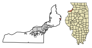
Hillsdale is a village in Rock Island County, Illinois, United States. The population was 531 at the time of the 2020 census, up from 523 at the 2010 census.

<span class="mw-page-title-main">Laurel, Indiana</span> Town in Indiana, United States

Laurel is a town in Laurel Township, Franklin County, Indiana, United States. The population was 512 at the 2010 census.

<span class="mw-page-title-main">Westernport, Maryland</span> Town in Maryland, United States

Westernport is a town in Allegany County, Maryland, United States, along the Georges Creek Valley. It is part of the Cumberland, MD-WV Metropolitan Statistical Area. The population was 1,888 at the 2010 census.

<span class="mw-page-title-main">Ferndale, Maryland</span> Census-designated place in Maryland, United States

Ferndale is a census-designated place (CDP) in Anne Arundel County, Maryland, United States. At the 2010 census, the population was 16,746.

<span class="mw-page-title-main">Lochearn, Maryland</span> Census-designated place in Maryland, United States

Lochearn is an unincorporated community and census-designated place in Baltimore County, Maryland, United States, located immediately to the west of the City of Baltimore. Per the 2020 census, the population was 25,511.

<span class="mw-page-title-main">Owings Mills, Maryland</span> Census-designated place in Maryland, United States

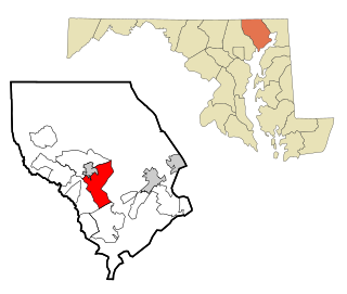
Owings Mills is an unincorporated community and census-designated place in Baltimore County, Maryland, United States. It is a suburb of Baltimore. Per the 2020 census, the population was 35,674. Owings Mills is home to the northern terminus of the Baltimore Metro Subway, and housed the Owings Mills Mall until its closure in 2015. It is also home to the Baltimore Ravens' headquarters facility, and the studios for Maryland Public Television. In 2008, CNNMoney.com named Owings Mills number 49 of the "100 Best Places to Live and Launch".

<span class="mw-page-title-main">Pikesville, Maryland</span> Census-designated place in Maryland, United States

Pikesville is a census-designated place (CDP) in Baltimore County, Maryland, United States. Pikesville is just northwest of the Baltimore city limits. It is the northwestern suburb closest to Baltimore.

<span class="mw-page-title-main">Reisterstown, Maryland</span> Census-designated place in Maryland, United States

Reisterstown is an unincorporated community and census-designated place in Baltimore County, Maryland, United States. As of the 2010 census, it had a population of 25,968.

<span class="mw-page-title-main">North East, Maryland</span> Town in Maryland, United States

North East is a town in Cecil County, Maryland, United States. It is located between Philadelphia and Baltimore. The population was 3,572 at the 2010 census.

<span class="mw-page-title-main">Deer Park, Maryland</span> Town in Maryland, United States

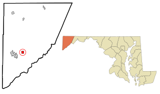
Deer Park is a town in Garrett County, Maryland, United States. The population was 399 at the 2010 census. It is part of the Pittsburgh Media Market.

<span class="mw-page-title-main">Kitzmiller, Maryland</span> Town in Maryland, United States

Kitzmiller is a town in Garrett County, Maryland, United States. The population was 321 at the 2010 census.

<span class="mw-page-title-main">Bel Air North, Maryland</span> Census-designated place in Maryland, United States

Bel Air North is a census-designated place (CDP) in Harford County, Maryland, United States. It is situated immediately north of the incorporated town of Bel Air. As of the 2010 census, the CDP population was 30,568, up from 25,798 in 2000.

<span class="mw-page-title-main">Bel Air South, Maryland</span> Census-designated place in Maryland, United States

Bel Air South is a census-designated place (CDP) in Harford County, Maryland, United States. The population was 47,709 at the 2010 census, up from 39,711 in 2000.

<span class="mw-page-title-main">Clear Spring, Maryland</span> Town in Maryland, United States

Clear Spring is a town in Washington County, Maryland, United States. The population was 358 at the 2010 census.

<span class="mw-page-title-main">Mashpee Neck, Massachusetts</span> Census-designated place in Massachusetts, United States

Mashpee Neck is a census-designated place (CDP) in the town of Mashpee in Barnstable County, Massachusetts, United States. The population was 1,000 at the 2010 census. It is the most populous of the seven CDPs in Mashpee.

<span class="mw-page-title-main">Hampton, Minnesota</span> City in Minnesota, United States

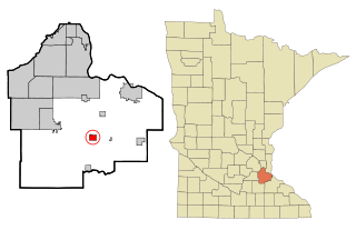
Hampton is a city in Dakota County, Minnesota, United States. The population was 689 at the 2010 census.

<span class="mw-page-title-main">Sandown, New Hampshire</span> Town in New Hampshire, United States

Sandown is a town in Rockingham County, New Hampshire, United States. The population was 6,548 at the 2020 census, up from 5,986 at the 2010 census.

<span class="mw-page-title-main">Cambria Township, Cambria County, Pennsylvania</span> Township in Pennsylvania, United States

Cambria Township is a township in Cambria County, Pennsylvania, United States. The population was 5,781 at the 2020 census. It is part of the Johnstown, Pennsylvania Metropolitan Statistical Area and geographically surrounds the borough of Ebensburg, the Cambria County seat.

<span class="mw-page-title-main">Lower Chanceford Township, Pennsylvania</span> Township in Pennsylvania, United States

Lower Chanceford Township is a township in York County, Pennsylvania, United States. The population was 3,028 at the 2020 census.

References

  1. "Hampstead". Maryland Manual. Retrieved June 25, 2017.
  2. "2020 U.S. Gazetteer Files". United States Census Bureau. Retrieved April 26, 2022.
  3. "Profile of General Population and Housing Characteristics: 2010 Demographic Profile Data (DP-1): Hampstead town, Maryland". United States Census Bureau . Retrieved August 6, 2012.
  4. Gannett, Henry (1905). The Origin of Certain Place Names in the United States. Govt. Print. Off. pp.  148.
  5. "National Register Information System". National Register of Historic Places . National Park Service. April 15, 2008.
  6. "US Gazetteer files: 2010, 2000, and 1990". United States Census Bureau. February 12, 2011. Retrieved April 23, 2011.
  7. "US Gazetteer files 2010". United States Census Bureau . Retrieved January 25, 2013.
  8. "Census of Population and Housing". Census.gov. Retrieved June 4, 2015.
  9. "U.S. Census website". United States Census Bureau . Retrieved January 25, 2013.
  10. "U.S. Census website". United States Census Bureau . Retrieved January 31, 2008.