Knox County, Maine

Last updated

Knox County
Knox County Courthouse, Rockland, Maine.jpg
Knox County Courthouse
Map of Maine highlighting Knox County.svg
Location within the U.S. state of Maine
Maine in United States.svg
Maine's location within the U.S.
Coordinates: 44°07′12″N69°07′40″W / 44.119938°N 69.127899°W / 44.119938; -69.127899
CountryFlag of the United States.svg United States
StateFlag of Maine.svg  Maine
FoundedApril 1, 1860
Named for Henry Knox
Seat Rockland
Largest cityRockland
Area
  Total1,144 sq mi (2,960 km2)
  Land365 sq mi (950 km2)
  Water779 sq mi (2,020 km2)  68%
Population
 (2020)
  Total40,607
  Density35/sq mi (14/km2)
Time zone UTC−5 (Eastern)
  Summer (DST) UTC−4 (EDT)
Congressional district 1st
Website www.knoxcountymaine.gov

Knox County is a county located in the state of Maine, United States. As of the 2020 census, the population was 40,607. [1] Its county seat is Rockland. [2] The county is named for Revolutionary War general and Secretary of War Henry Knox, [3] who lived in the county from 1795 until his death in 1806. The county was established on April 1, 1860, and is the most recent county to be created in Maine. It was carved from parts of Waldo and Lincoln counties. The Union Fair, started in 1868, began as the efforts of the North Knox Agricultural and Horticultural Society. [4]

Contents

Geography

According to the U.S. Census Bureau, the county has a total area of 1,144 square miles (2,960 km2), of which 365 square miles (950 km2) is land and 779 square miles (2,020 km2) (68%) is water. [5] It is the second-smallest county in Maine by land area. It was originally part of the Waldo Patent.

Adjacent counties

National protected areas

Demographics

Historical population
CensusPop.Note
1860 32,716
1870 30,823−5.8%
1880 32,8636.6%
1890 31,473−4.2%
1900 30,406−3.4%
1910 28,981−4.7%
1920 26,245−9.4%
1930 27,6935.5%
1940 27,191−1.8%
1950 28,1213.4%
1960 28,5751.6%
1970 29,0131.5%
1980 32,94113.5%
1990 36,31010.2%
2000 39,6189.1%
2010 39,7360.3%
2020 40,6072.2%
2023 (est.)40,977 [6] 0.9%
U.S. Decennial Census [7]
1790–1960 [8] 1900–1990 [9]
1990–2000 [10] 2010–2016 [11]

2000 census

At the 2000 census there were 39,618 people, 16,608 households, and 10,728 families living in the county. The population density was 108 people per square mile (42 people/km2). There were 21,612 housing units at an average density of 59 per square mile (23/km2). The racial makeup of the county was 98.28% White, 0.24% Black or African American, 0.22% Native American, 0.36% Asian, 0.01% Pacific Islander, 0.12% from other races, and 0.78% from two or more races. 0.57% of the population were Hispanic or Latino of any race. 25.4% were of English, 12.2% Irish, 11.7% United States or American, 7.5% German and 5.7% French ancestry. 97.1% spoke English and 1.5% French as their first language. [12] Of the 16,608 households 28.30% had children under the age of 18 living with them, 52.20% were married couples living together, 9.00% had a female householder with no husband present, and 35.40% were non-families. 29.00% of households were one person and 12.70% were one person aged 65 or older. The average household size was 2.31 and the average family size was 2.83.

The age distribution was 22.40% under the age of 18, 6.30% from 18 to 24, 27.40% from 25 to 44, 26.70% from 45 to 64, and 17.20% 65 or older. The median age was 41 years. For every 100 females there were 95.20 males. For every 100 females age 18 and over, there were 93.00 males.

The median household income was $36,774 and the median family income was $43,819. Males had a median income of $30,704 versus $22,382 for females. The per capita income for the county was $19,981. About 6.40% of families and 10.10% of the population were below the poverty line, including 11.90% of those under age 18 and 8.00% of those age 65 or over.

2010 census

At the 2010 census, there were 39,736 people, 17,258 households, and 10,662 families living in the county. [13] The population density was 108.8 inhabitants per square mile (42.0/km2). There were 23,744 housing units at an average density of 65.0 units per square mile (25.1 units/km2). [14] The racial makeup of the county was 97.1% white, 0.5% black or African American, 0.5% Asian, 0.4% American Indian, 0.2% from other races, and 1.4% from two or more races. Those of Hispanic or Latino origin made up 0.8% of the population. [13] In terms of ancestry, 31.3% were English, 19.0% were Irish, 12.8% were German, 6.9% were Scottish, and 5.9% were American. [15]

Of the 17,258 households, 25.4% had children under the age of 18 living with them, 48.2% were married couples living together, 9.4% had a female householder with no husband present, 38.2% were non-families, and 31.0% of households were made up of individuals. The average household size was 2.22 and the average family size was 2.75. The median age was 46.2 years. [13]

The median household income was $45,264 and the median family income was $55,830. Males had a median income of $40,712 versus $29,732 for females. The per capita income for the county was $25,291. About 7.9% of families and 12.5% of the population were below the poverty line, including 16.5% of those under age 18 and 9.8% of those age 65 or over. [16]

Politics

In 2012, Knox County voted 55% in favor of a measure to legalize same-sex marriage. [17]

Voter registration

Voter registration and party enrollment as of March 2024 [18]
Democratic 12,139
Unenrolled8,436
Republican 8,117
Green Independent 1,065
No Labels 343
Libertarian 83
Total30,183
United States presidential election results for Knox County, Maine [19]
Year Republican Democratic Third party
No.%No.%No.%
2020 9,98238.79%15,11058.72%6422.49%
2016 9,14839.52%12,44353.76%1,5566.72%
2012 8,24837.38%13,22359.92%5962.70%
2008 8,81638.36%13,72859.74%4361.90%
2004 10,10343.46%12,69054.59%4541.95%
2000 8,96843.74%9,45346.11%2,08010.15%
1996 6,19232.79%8,83946.81%3,85220.40%
1992 6,31031.03%7,63137.52%6,39731.45%
1988 10,15657.54%7,34341.60%1510.86%
1984 11,31165.00%6,02434.62%660.38%
1980 7,63148.98%5,73236.79%2,21814.24%
1976 8,31556.24%5,92240.05%5493.71%
1972 8,47870.19%3,60129.81%00.00%
1968 6,58555.25%5,11942.95%2141.80%
1964 4,40438.53%7,02261.43%40.03%
1960 9,08370.41%3,81629.58%10.01%
1956 8,86681.32%2,03718.68%00.00%
1952 8,79378.32%2,41421.50%200.18%
1948 5,37472.67%1,92426.02%971.31%
1944 5,59059.70%3,75840.14%150.16%
1940 6,53060.76%4,19739.05%200.19%
1936 6,56760.36%3,99136.69%3212.95%
1932 6,16955.28%4,76542.70%2252.02%
1928 6,66073.35%2,33225.68%880.97%
1924 4,91969.99%1,77025.18%3394.82%
1920 4,97960.85%2,97136.31%2332.85%
1916 2,21137.82%3,43458.74%2013.44%
1912 1,09719.95%2,75150.03%1,65130.02%
1908 2,22850.04%1,93243.40%2926.56%
1904 2,53854.78%1,86640.28%2294.94%
1900 2,76248.76%2,76548.81%1382.44%
1896 3,28661.72%1,90035.69%1382.59%
1892 2,32146.23%2,13642.54%56411.23%
1888 2,96552.28%2,29040.38%4167.34%
1884 2,81946.50%2,36439.00%87914.50%
1880 2,88041.28%3,65952.45%4376.26%

Communities

City

Towns

Plantation

Unorganized territories

Census-designated places

Other unincorporated villages

Public buildings

An addition to the Knox County Courthouse designed by Scott Simons Architects was completed in 2005. It is connected to an annex built in 1977 that is adjacent to the historic, original building that was finished in 1874. [20]

See also

Related Research Articles

<span class="mw-page-title-main">Waldo County, Maine</span> County in Maine, US

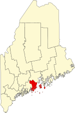
Waldo County is a county in the state of Maine, United States. As of the 2020 census, the population was 39,607. Its county seat is Belfast. The county was founded on February 7, 1827, from a portion of Hancock County and named after Brigadier-General Samuel Waldo, proprietor of the Waldo Patent.

<span class="mw-page-title-main">Lincoln County, Maine</span> County in Maine, United States

Lincoln County is a county located in the U.S. state of Maine. As of the 2020 census, the population was 35,237. Its seat is Wiscasset. The county was founded in 1760 by the Massachusetts General Court from a portion of York County, Massachusetts and named after the English city Lincoln, the birthplace of Massachusetts Bay Provincial Governor Thomas Pownall.

<span class="mw-page-title-main">Eagle Lake, Maine</span> Town in the state of Maine, United States

Eagle Lake is a town in Aroostook County, Maine, United States. The population was 772 at the 2020 census. The town was named by a body of troops heading from Bangor to the Aroostook War for the many eagles that they saw around the lake. A total of 49.0% of the population speaks French, reflecting a trend in Northeastern Maine.

<span class="mw-page-title-main">St. Francis, Maine</span> Town in the state of Maine, United States

St. Francis is a town in Aroostook County, Maine, United States on the Canada–United States border at the junction of the St. Francis River and the Saint John River. The population was 438 at the 2020 census. First settled by English speakers from southern Maine, the original population has been supplanted by French-speaking Acadians.

<span class="mw-page-title-main">Franklin, Maine</span> Town in the state of Maine, United States

Franklin is a town in Hancock County, Maine, United States. The population was 1,567 at the 2020 census. The town's namesake is Benjamin Franklin.

<span class="mw-page-title-main">Gouldsboro, Maine</span> Town in the state of Maine, United States

Gouldsboro is a town and municipality in Hancock County, Maine, United States on the Schoodic Peninsula. The town was named for Robert Gould, a landholder in the town. The town has many historically separate fishing villages, summer colonies and communities, including Birch Harbor, Prospect Harbor, South Gouldsboro, West Gouldsboro, Summer Harbor, Wonsqueak Harbor, Bunker's Harbor, Chicken Mill, Jones' Pond, Westbay, and Corea. The population was 1,703 at the 2020 census.

<span class="mw-page-title-main">Verona Island, Maine</span> Town in Maine, United States

Verona Island is a town located on an island of the same name in the Penobscot River in Hancock County, Maine, United States. The population was 507 at the 2020 census.

<span class="mw-page-title-main">Appleton, Maine</span> Town in the state of Maine, United States

Appleton is a town in Knox County, Maine, United States. It is about 15 miles inland from Penobscot Bay and coastal towns such as Camden and Rockland, about 30 miles east of the state capital of Augusta. The population was 1,411 at the 2020 census.

<span class="mw-page-title-main">Cushing, Maine</span> Town in the state of Maine, United States

Cushing is a town in Knox County, Maine, United States. The population was 1,502 at the 2020 census. A favorite of artists for its unspoiled natural setting, Cushing includes the villages of North Cushing, Cushing, South Cushing, and Pleasant Point.

<span class="mw-page-title-main">Owls Head, Maine</span> Town in the state of Maine, United States

Owls Head is a town in Knox County, Maine, United States. The population was 1,504 at the 2020 census. A resort and fishing area, the community is home to the Knox County Regional Airport. It includes the village of Ash Point.

<span class="mw-page-title-main">Rockland, Maine</span> City in Maine, United States

Rockland is a city and county seat of Knox County, Maine, United States. As of the 2020 census, the town population was 6,936. The city is a popular tourist destination. It is a departure point for the Maine State Ferry Service to the islands of Penobscot Bay: Vinalhaven, North Haven and Matinicus.

<span class="mw-page-title-main">South Thomaston, Maine</span> Town in the state of Maine, United States

South Thomaston is a town in Knox County, Maine, United States. The population was 1,511 at the 2020 census. A fishing and resort area, the town includes the village of Spruce Head.

<span class="mw-page-title-main">Warren, Maine</span> Town in the state of Maine, United States

Warren is a town in Knox County, Maine, United States. The population was 4,865 at the 2020 census. It includes the villages of East Warren, Warren and South Warren, the latter home to the Maine State Prison and minimum security Bolduc Correctional Facility.

<span class="mw-page-title-main">Hartford, Maine</span> Town in the state of Maine, United States

Hartford is a town in Oxford County, Maine, United States. Hartford is included in the Lewiston-Auburn, Maine metropolitan New England City and Town Area. The population was 1,203 at the 2020 census.

<span class="mw-page-title-main">Brooks, Maine</span> Town in the state of Maine, United States

Brooks is a town in Waldo County, Maine, United States. The population was 1,010 at the 2020 census.

<span class="mw-page-title-main">Prospect, Maine</span> Town in the state of Maine, United States

Prospect is a town in Waldo County, Maine, United States. The population was 698 at the 2020 census.

Baring Plantation is a plantation in Washington County, Maine, United States. The population was 201 at the 2020 census. The plantation is named for Alexander Baring, 1st Baron Ashburton, the British negotiator of the Webster–Ashburton Treaty which ended the Aroostook War in 1838–1839.

<span class="mw-page-title-main">Thomaston (CDP), Maine</span> Census-designated place in Maine, United States

Thomaston is a census-designated place (CDP) comprising the main village in the town of Thomaston in Knox County, Maine, United States. The population was 1,875 at the 2010 census, out of 2,781 in the town of Thomaston as a whole.

<span class="mw-page-title-main">Thomaston, Maine</span> Town in the state of Maine, United States

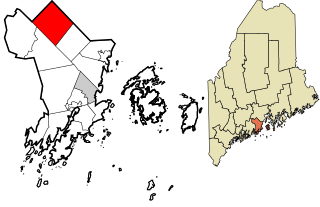
Thomaston, formerly known as Fort St. Georges, Fort Wharf, and Lincoln, is a town in Knox County, Maine, United States. The population was 2,739 at the 2020 census. Noted for its antique architecture, Thomaston is an old port popular with tourists. The town was named after Major General John Thomas.

<span class="mw-page-title-main">Bingham, Maine</span> Town in the state of Maine, United States

Bingham is a town in Somerset County, Maine, United States. The population was 866 at the 2020 census. Bingham is a historic town located beside the Kennebec River.

References

  1. "Census - Geography Profile: Knox County, Maine". United States Census Bureau . Retrieved November 21, 2021.
  2. "Find a County". National Association of Counties. Archived from the original on May 31, 2011. Retrieved June 7, 2011.
  3. Gannett, Henry (1905). The Origin of Certain Place Names in the United States. Government Printing Office. pp.  177.
  4. "The Birth of the Union Fair: Its History, Its Promise". Archived from the original on October 2, 2011. Retrieved October 16, 2011.
  5. "2010 Census Gazetteer Files". United States Census Bureau. August 22, 2012. Archived from the original on September 9, 2014. Retrieved September 7, 2014.
  6. "Annual Estimates of the Resident Population for Counties: April 1, 2020 to July 1, 2023". United States Census Bureau. Retrieved April 3, 2024.
  7. "U.S. Decennial Census". United States Census Bureau. Retrieved September 7, 2014.
  8. "Historical Census Browser". University of Virginia Library. Retrieved September 7, 2014.
  9. "Population of Counties by Decennial Census: 1900 to 1990". United States Census Bureau. Retrieved September 7, 2014.
  10. "Census 2000 PHC-T-4. Ranking Tables for Counties: 1990 and 2000" (PDF). United States Census Bureau. Archived (PDF) from the original on March 27, 2010. Retrieved September 7, 2014.
  11. "State & County QuickFacts". United States Census Bureau. Archived from the original on June 6, 2011. Retrieved August 19, 2013.
  12. "U.S. Census website". United States Census Bureau . Retrieved January 31, 2008.
  13. 1 2 3 "DP-1 Profile of General Population and Housing Characteristics: 2010 Demographic Profile Data". United States Census Bureau. Archived from the original on February 13, 2020. Retrieved January 21, 2016.
  14. "Population, Housing Units, Area, and Density: 2010 - County". United States Census Bureau. Archived from the original on February 13, 2020. Retrieved January 21, 2016.
  15. "DP02 Selected Social Characteristics in the United States – 2006-2010 American Community Survey 5-Year Estimates". United States Census Bureau. Archived from the original on February 13, 2020. Retrieved January 21, 2016.
  16. "DP03 Selected Economic Characteristics – 2006-2010 American Community Survey 5-Year Estimates". United States Census Bureau. Archived from the original on February 13, 2020. Retrieved January 21, 2016.
  17. "2016 Election Results: President Live Map by State, Real-Time Voting Updates". Politico . November 8, 2016.
  18. Bureau of Corporations, Elections & Commissions. "Registered & Enrolled Voters Statewide" (PDF). Maine SOS. Retrieved April 9, 2024.
  19. Leip, David. "Dave Leip's Atlas of U.S. Presidential Elections". uselectionatlas.org. Retrieved February 22, 2021.
  20. "Knox County Courthouse". Maine Commercial Construction Company | Wright-Ryan Construction. Retrieved May 20, 2016.

44°02′N69°02′W / 44.03°N 69.03°W / 44.03; -69.03