Matinicus Isle, Maine

Last updated
Matinicus Island, Maine
View of the Harbor, Matinicus, ME.jpg
View of the harbor c.1908
Knox County Maine incorporated and unincorporated areas Matinicus Isle plantation highlighted.svg
Location in Knox County and the state of Maine.
Coordinates: 43°51′40″N68°53′35″W / 43.86111°N 68.89306°W / 43.86111; -68.89306 Coordinates: 43°51′40″N68°53′35″W / 43.86111°N 68.89306°W / 43.86111; -68.89306
Country United States
State Maine
County Knox
Organized1840
Area
  Total9.9 sq mi (26 km2)
  Land2.3 sq mi (6 km2)
  Water7.6 sq mi (20 km2)
Elevation
0−100 ft (0−30.5 m)
Population
 (2020)
  Total53
  Density5.4/sq mi (2.0/km2)
Time zone UTC-5 (Eastern (EST))
  Summer (DST) UTC-4 (EDT)
Zip code
04851
Area code 207
FIPS code 23-44165
GNIS feature ID0582584

Matinicus Isle is an island plantation in Knox County, Maine, United States. The island is located within Penobscot Bay about 20 miles east of the mainland coast and is accessible by state ferry service from Rockland or by air taxi from Knox County Regional Airport. Matinicus is the farthest inhabited land off the east coast into the Atlantic Ocean which is part of the United States. [1] The plantation is both a year-round island community and a summer colony. The population was 53 at the 2020 census. [2]

Contents

History

Matinicus is an Abenaki word meaning "far out island."

The island was probably long used by the indigenous people of North America as a place for hunting and gathering, and Europeans probably started visiting the island in the 16th century. [3] Early documentation of the island comes from John Josselyn's 1671 account of New England:

Sagadehock to Nova Scotia is called the Duke of York's Province. Here Pemaquid, Matinicus, Monhegan, Cape Anawhagen…are all filled with dwelling houses and stages for fisherman, and have plenty of cattle, arable lands and marshes. [3]

The island is also mentioned in the May 1717 deposition of two sailors whose trading ship was commandeered off of Cape Cod by pirates from the ship Whydah . They testified that they were forced to sail north with the pirates (under captain Richard Noland of the Whydah's sister ship Anne Galley), who then took a launch "to Matinicus, where they took a sloop belonging to Colonel [Stephen] Minot, one shallop belonging to Captain [John] Lane and three schooners." [4]

In March 1726, Lieutenant Governor Dummer of the Massachusetts Bay Colony documented the early tension between the Native Americans and Europeans in a letter to Captain John Giles:

I very much resent this liberty [the Native Americans at Matinicus] have taken in killing the [livestock] which belong to the English, which is contrary to the Articles of Peace and that common justice which the English and Indians owe to one another. [3]

In 1750, Ebenezer Hall became the island's first permanent settler. [3] Accompanied by his family, he built a house, commenced fishing and farming, and claimed territorial rights to the island. He burned the grass on nearby Green Island to produce hay for his livestock, infuriating the Penobscot tribe, who still used the islands for fishing and sealing. Twice the tribe wrote letters to Royal authorities in Boston, complaining about Hall. In the second, delivered for forwarding on April 25, 1753, to Fort Richmond, they warned, "if you don't remove him in two months, we shall be obliged to do it ourselves." [3] Though Hall was ordered to leave Matinicus, he continued his residence there, and the Penobscots waited not two months but a little over four years before taking action. After a multiple day siege on his house, they killed and scalped Hall on June 10, 1757.

In the following decades several families, including that of Ebenezer Hall's son, moved to the island, and at the census of 1790 there was a total population of 59. [3] The population continued to grow, and on October 22, 1840, the island was formally organized as a plantation.

Air taxi landing at Matinicus Island Airport Air taxi landing 35ME.jpg
Air taxi landing at Matinicus Island Airport

As a maritime community, the residents of Matinicus have long worked as sailors and fishermen. The early days of fishing for cod, mackerel, and herring gradually gave way to lobster fishing, which continues as the dominant industry on the island today. The importance of this industry to the livelihood of island residents has led to territorial disputes. In July 2009, an island fisherman shot and wounded a fellow fisherman in a dispute over the locations of individual lobster-fishing rights. [5]

The plantation has one church, the Congregational Church of Matinicus, which was built in 1906 and currently holds Sunday services during the summer months and serves as a general community function hall. [6] [7] The island is a routine stop for the Maine Seacoast Mission's vessel the Sunbeam, which offers pastoral care as well as nursing and telemedicine facilities. [8]

The island's inhabitants have served as first responders to emergencies in the waters of Penobscot Bay. On January 16, 1992, residents of Matinicus responded to a distress call from the O.A. Harkness, a nearby sinking tugboat, ultimately rescuing the three crew members. [9] On July 17, 2011, island fishermen rescued 4 occupants of an airplane that ditched into the waters off of Matinicus. [10]

Panorama of the harbor in 2006 Harbor Low Tide Panorama (Matinicus Island, Maine).jpg
Panorama of the harbor in 2006

Matinicus Island Library, founded in 2016, was featured by Smithsonian Magazine in 2022 for buying books banned by other organizations in the United States. [11] The library is run by volunteers and partially funded by the Stephen and Tabitha King Foundation.

Geography

Harbor tidal pool Harbor Tidal Pool (Matinicus Island, ME).jpg
Harbor tidal pool

Matinicus Isle plantation is an archipelago located on the southeastern fringes of Penobscot Bay in the Gulf of Maine, part of the Atlantic Ocean. According to the United States Census Bureau, the plantation has a total area of 9.9 square miles (26 km2), of which 2.3 square miles (6.0 km2) is land and 7.6 square miles (20 km2) is water. [12] Matinicus Island, the largest land mass in the archipelago, spans approximately 2 miles (3.2 km) in length and 1-mile (1.6 km) in width for an area of about 720 acres (290 ha). [3] The elevation ranges from 0 to 100 feet (30.5 m). [13] Matinicus Isle is located approximately 1 mile (1.6 km) north of Criehaven Isle.

The shoreline consists of rocky coves and sandy beaches. The island experiences semidiurnal tides with a difference in sea level of up to 10–11 feet (3.0–3.4 m) between high and low tides. [14]

There are ten major fishing grounds around Matinicus Isle that the island's fishermen use to catch cod, haddock, pollock, cusk, and lobster. [15]

Climate

Matinicus has a humid continental climate (Köppen climate classification Dfb) with warm, humid summers and cold winters. Compared to the mainland, seasonal climate fluctuations are somewhat moderated by the Atlantic Ocean, resulting in relatively cooler summers and milder winters. Springs are also some of the coolest in the state, and even the whole country. Summers are almost nonexistent due to the moderating effect of the ocean, which also helps to keep year round temperatures above zero and below 75. [16] [17] The common winter freeze and thaw cycles produce much slush. [3] Nor'easters, such as the Blizzard of 1978, can be destructive to the shoreline and infrastructure on the island. [18] Tropical disturbances have been known to occasionally strike the area, typically in the late summer and fall, but they are not very common this far north.

Climate data for Matinicus Island (1981–2010 Averages)
MonthJanFebMarAprMayJunJulAugSepOctNovDecYear
Average high °F (°C)33.6
(0.9)
33.8
(1.0)
37.5
(3.1)
43.3
(6.3)
52.3
(11.3)
59.3
(15.2)
64.0
(17.8)
65.6
(18.7)
62.5
(16.9)
53.7
(12.1)
46.6
(8.1)
39.1
(3.9)
49.3
(9.6)
Daily mean °F (°C)27.5
(−2.5)
28.3
(−2.1)
37.1
(2.8)
40.3
(4.6)
48.3
(9.1)
55.1
(12.8)
60.1
(15.6)
61.8
(16.6)
58.4
(14.7)
49.7
(9.8)
42.7
(5.9)
33.8
(1.0)
45.3
(7.4)
Average low °F (°C)21.4
(−5.9)
22.9
(−5.1)
28.6
(−1.9)
37.2
(2.9)
44.4
(6.9)
50.9
(10.5)
56.3
(13.5)
58.1
(14.5)
54.2
(12.3)
45.8
(7.7)
38.7
(3.7)
28.5
(−1.9)
40.6
(4.8)
Average precipitation inches (mm)3.87
(98)
3.41
(87)
4.63
(118)
4.50
(114)
3.92
(100)
3.83
(97)
3.51
(89)
3.11
(79)
3.91
(99)
4.50
(114)
5.04
(128)
4.40
(112)
48.63
(1,235)
[ citation needed ]

Demographics

Historical population
CensusPop.Note
1790 59
1800 53−10.2%
1810 9579.2%
1820 10510.5%
1830 14538.1%
1840 19232.4%
1850 22014.6%
1860 27625.5%
1870 2770.4%
1880 243−12.3%
1890 196−19.3%
1900 184−6.1%
1910 179−2.7%
1920 140−21.8%
1930 15611.4%
1940 112−28.2%
1950 18867.9%
1960 100−46.8%
1970 90−10.0%
1980 66−26.7%
1990 671.5%
2000 51−23.9%
2010 7445.1%
2020 53−28.4%
U.S. Decennial Census [19]

As of the 2010 census, there were 74 people, 41 households, and 16 families residing on Matinicus. [20] The population density was 32.2 inhabitants per square mile (12.4/km2).

The average age of the population was 47.0 years. In terms of age distribution, 20.2% of the population was under the age of 19 years, 66.2% was between the ages of 20 to 64 years, and 13.6% was between the ages of 65 and 84 years. The population was 54.1% male and 45.9% female. The racial makeup of the plantation was 100% white.

The average household size was 1.8 people, and the average family size was 2.8 people. 17.1% of households had individuals under the age of 18 years, and 22.0% had individuals over the age of 64 years. 34.1% of households consisted of married couples living together, and 61.0% were non-families.

There were 147 housing units at an average density of 63.9 per square mile (24.7/km2). 41 homes were occupied, and 99 homes were for seasonal, recreational, or occasional use.

As estimated by the American Community Survey, the per capita income for the plantation in 2015 was $28,801, the mean income for a household was $67,000, and the mean income for a family was $123,354. [20] 22.1% of the population was living below the poverty line.

See also

Related Research Articles

<span class="mw-page-title-main">Penobscot County, Maine</span> County in Maine, United States

Penobscot County is a county in the U.S. state of Maine, named for the Penobscot people in Wabanakik. As of the 2020 census, the population was 152,199. Its county seat is Bangor. The county was established on February 15, 1816, from part of Hancock County when the area was still part of Massachusetts. Penobscot County is home to the University of Maine.

<span class="mw-page-title-main">Hancock County, Maine</span> County in Maine, United States

Hancock County is a county located in the U.S. state of Maine. As of the 2020 census, the population was 55,478. Its county seat is Ellsworth. The county was incorporated on June 25, 1789, and named for John Hancock, the first governor of the Commonwealth of Massachusetts.

<span class="mw-page-title-main">Aroostook County, Maine</span> County in Maine, United States

Aroostook County is a county in the U.S. state of Maine along the Canada–U.S. border. As of the 2020 census, the population was 67,105. Its county seat is Houlton, with offices in Caribou and Fort Kent.

<span class="mw-page-title-main">Stonington, Maine</span> Town in the state of Maine, United States

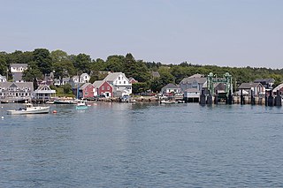
Stonington is a town in Hancock County, Maine, United States. It's located on the southern portion of the island of Deer Isle. The population was 1,056 at the 2020 census. It includes the villages of Burnt Cove, Oceanville, Green Head, and Clam City. A picturesque working waterfront and tranquil tourist destination in eastern Penobscot Bay, Stonington has consistently ranked among the top lobster ports in the county and is the largest lobster port in Maine. In 2011, 14,854,989 pounds of lobster were landed by Stonington fishermen with a value of $46.3 million.

<span class="mw-page-title-main">Isle au Haut, Maine</span> Town in the state of Maine, United States

Isle au Haut is a town in Knox County, Maine, United States, on an island of the same name in Penobscot Bay. The population was 92 at the 2020 census. Home to portions of Acadia National Park, Isle au Haut is accessible by ferry from Stonington, Maine.

<span class="mw-page-title-main">North Haven, Maine</span> Town in the state of Maine, United States

North Haven is a town and island in Knox County, Maine, United States, in Penobscot Bay. The town is both a year-round island community and a prominent summer colony. The population was 417 at the 2020 census. North Haven is accessible by thrice-daily state ferry service from Rockland, or by air taxi from Knox County Regional Airport.

<span class="mw-page-title-main">Rockland, Maine</span> City in Maine, United States

Rockland is a city in Knox County, Maine, in the United States. As of the 2020 census, the town population was 6,936. It is the county seat of Knox County. The city is a popular tourist destination. It is a departure point for the Maine State Ferry Service to the islands of Penobscot Bay: Vinalhaven, North Haven and Matinicus.

<span class="mw-page-title-main">Vinalhaven, Maine</span> Town in the state of Maine, United States

Vinalhaven is a town on the larger of the two Fox Islands in Knox County, Maine, United States. Vinalhaven is also used to refer to the island itself. The population was 1,279 at the 2020 census. It is home to a thriving lobster fishery and hosts a summer colony. Since there is no bridge to the island, Vinalhaven is primarily accessible from Rockland via an approximately 75-minute state ferry ride across West Penobscot Bay, or by air taxi from Knox County Regional Airport.

<span class="mw-page-title-main">Monhegan, Maine</span> Plantation in Maine, United States

Monhegan is an island in the Gulf of Maine. A plantation, a minor civil division in the state of Maine falling between unincorporated area and a town, it is located about 12 nautical miles (22 km) off the mainland and is part of Lincoln County, Maine. The population was 64 at the 2020 census. The plantation comprises its namesake island and the uninhabited neighboring island of Manana. The island is accessible by scheduled boat service from Boothbay Harbor, New Harbor and Port Clyde. Visitors' cars are not allowed on the island. It was designated a United States National Natural Landmark for its coastal and island flora in 1966.

Carroll Plantation is a plantation in Penobscot County, Maine, United States. The plantation was named for Daniel Carroll, a signer of the United States Constitution. It is located along Maine State Route 6 near its intersection with State Route 170. The population was 138 at the 2020 census. It is part of the Bangor Metropolitan Statistical Area.

<span class="mw-page-title-main">Old Town, Maine</span> City in Maine, United States

Old Town is a city in Penobscot County, Maine, United States. The population was 7,431 at the 2020 census. The city's developed area is chiefly located on the relatively large Marsh Island, though its boundaries extend beyond that. The island is surrounded and defined by the Penobscot River to the east and the Stillwater River to the west.

Seboeis Plantation is a plantation in Penobscot County, Maine, United States. The population was 40 at the 2020 census.

Criehaven is an alternative name for Ragged Island, an unorganized territory in Knox County, Maine, United States. Criehaven was formerly a plantation including Ragged Island just south of Matinicus Isle in outer Penobscot Bay, plus Matinicus Rock to its southeast, and Seal Island, the location of Seal Island National Wildlife Refuge, to its northeast. Criehaven surrendered its organization and reverted to an unorganized territory in 1925, but the name persists.

<span class="mw-page-title-main">Millinocket, Maine</span> Town in the state of Maine, United States

Millinocket is a town in Penobscot County, Maine, United States. The population was 4,114 at the 2020 census.

<span class="mw-page-title-main">Orono, Maine</span> Town in Maine, United States

Orono is a town in Penobscot County, Maine, United States. Located on the Penobscot and Stillwater rivers, it was first settled by American colonists in 1774. They named it in honor of Chief Joseph Orono, a sachem of the indigenous Penobscot nation who long occupied this territory.

<span class="mw-page-title-main">Penobscot Bay</span> Bay in Maine, United States

Penobscot Bay is an inlet of the Gulf of Maine and Atlantic Ocean in south central Maine. The bay originates from the mouth of Maine's Penobscot River, downriver from Belfast. Penobscot Bay has many working waterfronts including Rockland, Rockport, and Stonington, and Belfast upriver. Penobscot Bay is between Muscongus Bay and Blue Hill Bay, just west of Acadia National Park.

<span class="mw-page-title-main">Penobscot Island Air</span> Airline of the United States

Penobscot Island Air is a small regional airline based at Knox County Regional Airport, Maine, United States (RKD) operating from a private terminal. The airline operates scheduled service to the islands in Maine's Penobscot Bay and offers private charter land and seaplane flights throughout the region.

Damariscove is an uninhabited island that is part of Boothbay Harbor in Lincoln County, Maine, about 5 nautical miles (9.3 km) off the coast at the mouth of the Damariscotta River. The long, narrow island is approximately 2 miles (3.2 km) long and 1,500 feet (460 m) at its widest point. The island has served in the past as a fishing settlement and a United States Coast Guard life saving station.

Milford is a town in Penobscot County, Maine, United States. It is located across the Penobscot River from the city of Old Town. The population of Milford was 3,069 at the 2020 census. The town's slogan is the "Best little town by a dam site," referring to the Milford Dam abutting Milford on the Penobscot River, south of the Penobscot Indian Island Reservation.

Genevieve Kurilec McDonald is an American Democratic politician, lobster boat captain, and fisheries advocate from Maine. In 2018, she was the first female commercial fisherman to be elected to the Maine House of Representatives. McDonald represented House District #134: Cranberry Isles, Deer Isle, Frenchboro, Isle au Haut, North Haven, Southwest Harbor, Stonington, Swan's Island, Tremont, Vinalhaven, and Marshall Island. In 2013, she successfully led a social media campaign to prompt fishing gear producer Grundéns to produce commercial fishing gear for women. In June 2014, McDonald became the first woman to serve on the Maine Department of Marine Resources Lobster Advisory Council (LAC). McDonald resigned her House seat effective on May 10, 2022, the day after the last Legislative Day of the Second Regular Session of the 130th Maine Legislature.

References

  1. Seelye, Katharine Q. (23 February 2018). "Life on an Island: Silence, Beauty and a Long Wait for the Ferry". The New York Times.
  2. "Census - Geography Profile: Matinicus Isle plantation, Knox County, Maine". United States Census Bureau . Retrieved January 9, 2022.
  3. 1 2 3 4 5 6 7 8 Long, Charles A. E. (1926). Matinicus Isle, its story and its people. Lewiston, Me: Lewiston Journal Printshop via Hathi Trust Digital Library.
  4. Privateering and Piracy in the Colonial Period by J. Franklin Jameson.
  5. Curtis, Abigail (25 July 2009). "Shooting on Matinicus shifts fishermen's focus to 'self-preservation'". The Bangor Daily News. Retrieved 2017-02-15.
  6. Job, Herbert (21 March 1909). ""Dedication of The Congregational Church of Matinicus [Maine], June Six" by Herbert Keightley Job". Early Ornithology Lantern Slides by Herbert Keightley Job. Retrieved 2017-02-13.
  7. Murray, Eva (2006-07-01). "Matinicus marks centennial of island church - with running water!". The Working Waterfront Archives. Retrieved 2017-02-13.
  8. "Islands - Maine Seacoast Mission". Maine Seacoast Mission. Retrieved 2017-02-13.
  9. "Miraculous rescue off the Maine coast". Yankee. 57. February 1993.
  10. Steeves, Heather (20 July 2011). "Pilot helps lead rescue efforts after plane crash off Matinicus". The Bangor Daily News. Retrieved 2017-02-13.
  11. Magazine, Smithsonian; Williams, Emily. "This Small Library Off the Coast of Maine Is Collecting Banned Books". Smithsonian Magazine. Retrieved 2022-09-05.
  12. "2015 U.S. Gazetteer Files Record Layouts". www.census.gov. Retrieved 2017-02-13.
  13. "The National Map: Elevation". nationalmap.gov. U.S. Geological Survey. Retrieved 2017-02-13.
  14. "Tide Charts | Matinicus Harbor, Wheaton Island | Feb/2017 | Maine". me.usharbors.com. Retrieved 2017-02-13.
  15. "Matinicus Rock & Matinicus Island Area Fishing Grounds" . Retrieved 2017-02-13.
  16. "Matinicus Rock - Climate data (994370)". www.tutiempo.net. Retrieved 2020-07-31.
  17. "Matinicus Climate".
  18. "MEMA: Photo Album Display". www.maine.gov. Retrieved 2017-02-16.
  19. "Census of Population and Housing". Census.gov. Retrieved June 4, 2015.
  20. 1 2 "U.S. Census website". United States Census Bureau . Retrieved 2017-02-13.