Wells, Maine

Last updated

Wells, Maine
Wells maine municipal office building 2006.jpg
Town Hall
Flag of Wells, Maine.png
Motto: 
The Friendliest Town In Maine
USA Maine location map.svg
Red pog.svg
Wells, Maine
Location within the state of Maine
Coordinates: 43°19′13″N70°36′42″W / 43.32028°N 70.61167°W / 43.32028; -70.61167
Country United States
State Maine
County York
Founded1643
Incorporated1653
Government
  Type Town Meeting, Board of Selectmen, Town Manager
  Town ManagerMichael Pardue
Area
[1]
  Total73.61 sq mi (190.6 km2)
  Land57.55 sq mi (149.1 km2)
  Water16.06 sq mi (41.6 km2)
Elevation
177 ft (54 m)
Population
 (2020)
  Total11,314
  Density150/sq mi (59/km2)
Time zone UTC−5 (Eastern (EST))
  Summer (DST) UTC−4 (EDT)
ZIP Codes
04054 (Moody), 04090 (Wells)
Area code 207
FIPS code 23-81475
GNIS feature ID0582799
Website www.wellstown.org

Wells is a resort town in York County, Maine, United States. Founded in 1643, it is the third-oldest town in Maine. [2] The population was 11,314 at the 2020 census. [3] Wells Beach is a popular summer destination.

Contents

History

Wells Police Department color guard marching in the town's 350th anniversary parade. WellsMainePoliceDeptColorGuard.jpg
Wells Police Department color guard marching in the town's 350th anniversary parade.

The Abenaki Indians called the area Webhannet, meaning "at the clear stream", a reference to the Webhannet River.

Edmund Littlefield, an immigrant from the wool regions of Titchfield, England, built the first gristmill and later a woolen mill on the Webhannet River, becoming known as "The Father of Wells," where a monument commemorates his contribution. In 1622, the Plymouth Company in England awarded to Sir Ferdinando Gorges, Lord Proprietor of Maine, territory which included the Plantation of Wells. His young cousin, Thomas Gorges, acting as deputy and agent, in 1641 granted to Rev. John Wheelwright and other settlers from Exeter, New Hampshire the right to populate the land from northeast of the Ogunquit River to southwest of the Kennebunk River. Following the death of the elder Gorges in 1647, the Massachusetts Bay Colony laid claim to Maine. On July 5, 1653, Wells was incorporated, the third town in Maine to do so, and named after Wells, England, a small cathedral city in the county of Somerset. After the restoration of Charles II and a meeting in Wells of the trustees of the late Ferdinando Gorges, the British authorities gave a general outline for the local civil and military administration on December 7, 1661. [4] Wells included Kennebunk, which was set off the year Maine became a state in 1820, and Ogunquit, designated a village within Wells by the legislature in 1913, then set off in 1980. [5]

Wells was the resilient northeastern frontier of English colonial settlement. Except for a few forts and garrisons, early attempts to colonize Maine above Wells were abandoned because of attacks by Native Americans, who resented the encroachment on their territory. Wells endured three major attacks, most famously the Raid on Wells in 1692. The region became less dangerous, however, after the Battle of Louisburg in 1745. [5]

Many early Wells settlers joined the Continental Army; some became Revolutionary War heroes, including Captains Samuel Gooch, Nathanial Littlefield, and Jeremiah Storer. Ocean View Cemetery on Post Road contains a Civil War monument and plot honoring its service members. Visitors can walk to Founder's Park just off of Post Road onto Sanford Road, which includes a light walking trail, picnic area, and the first settlement home. Monuments list the names of Wells' founding families.

The town developed as a farming community, producing hay and vegetables. Other industries included shipbuilding and fisheries. In the 19th century, with the arrival of the railroad, the town's sandy beaches attracted tourists. Many inns and hotels were built along the seashore. Today, tourism remains important to the economy. [6]

Wells celebrated its 350th anniversary in 2003. [7] The year-long celebration included a New Year's Eve party with fireworks, parade, a visit by the traveling Russian circus, concerts, historical reenactments, and more. The town commissioned a member of the celebration committee, Kristi Borst, to design a town flag. Her design portrays historic aspects of the Town's settlement and agriculture as well as the 2003 Town Hall and focus on tourism represented by a train. Also included is the motto she penned for the project: "Proud of our Past, Ready for our Future". [8]

Geography

Wells is on the southern coast of Maine, surrounded by Kennebunk to the northeast, Sanford to the northwest, North Berwick to the west, South Berwick to the southwest, and Ogunquit to the south.

According to the United States Census Bureau, the town has a total area of 73.61 square miles (190.65 km2), of which 57.55 square miles (149.05 km2) is land and 16.06 square miles (41.60 km2) is water. [1] Wells is drained by the Webhannet River. The highest point in town is an unnamed hill located one-half mile south of the intersection of State Route 9 and Bragdon Road, which is 360 feet (110 m) above sea level. The lowest elevation is sea level, along the coastline with the Atlantic Ocean.

Wells is part of the Portland-South Portland-Biddeford Metropolitan Statistical Area.

Transportation

B&M railroad station in 1910. Railroad Station, Wells Beach, ME.jpg
B&M railroad station in 1910.

There are several transportation corridors connecting Wells with other communities:

Access to the Amtrak national passenger rail system is available at the Wells Regional Transportation Center, which is served by 10 Downeaster trains per day. The center has a park and ride lot and is adjacent to the I-95 interchange.

Education

Wells Junior High School (built in 1937 as the third Wells High School). Wells High School Wells Maine 1937 Postcard.jpg
Wells Junior High School (built in 1937 as the third Wells High School).

There are four educational institutions in Wells: Wells Elementary School (kindergarten through fourth grade), Wells Junior High School (fifth grade through eighth grade), Wells High School (ninth grade through twelfth grade, as well as adult education programs), and York County Community College.

Wells is a member of the Wells-Ogunquit Community School District.

Places of worship

First Congregational Church (now the Meetinghouse Museum). First Congregational Church, Wells ME.jpg
First Congregational Church (now the Meetinghouse Museum).

Baptist

Christian, interdenominational

Church of the Nazarene

Pentecostal

Roman Catholic

Old Catholic

United Church of Christ

Points of interest

Wells Beach in 1908 Hotel Winona & Wells Beach, ME.jpg
Wells Beach in 1908
Wells Beach in 2017 Southern end of the Wells Beach IMG 2247 FRD.jpg
Wells Beach in 2017

Notable people

Wells High School Marching Band WellsHighSchoolMarchingBand1999.jpg
Wells High School Marching Band
Wells Fire Department tower truck #6 WellsMaineTower6.jpg
Wells Fire Department tower truck #6

Demographics

Historical population
CensusPop.Note
1790 3,070
1800 3,69220.3%
1810 4,48921.6%
1820 2,660−40.7%
1830 2,97812.0%
1840 2,9780.0%
1850 2,945−1.1%
1860 2,878−2.3%
1870 2,773−3.6%
1880 2,450−11.6%
1890 2,029−17.2%
1900 2,007−1.1%
1910 1,908−4.9%
1920 1,9431.8%
1930 2,0475.4%
1940 2,1444.7%
1950 2,3218.3%
1960 3,52852.0%
1970 4,44826.1%
1980 8,21184.6%
1990 7,778−5.3%
2000 9,40020.9%
2010 9,5892.0%
2020 11,31418.0%
[13] [14] [15]

2010 Census

As of the census [16] of 2010, there were 9,589 people, 4,120 households, and 2,734 families living in the town. The population density was 166.6 inhabitants per square mile (64.3/km2). There were 8,557 housing units at an average density of 148.7 per square mile (57.4/km2). The racial makeup of the town was 97.2% White, 0.5% African American, 0.2% Native American, 0.6% Asian, 0.2% from other races, and 1.3% from two or more races. Hispanic or Latino of any race were 1.2% of the population.

There were 4,120 households, of which 24.5% had children under the age of 18 living with them, 54.6% were married couples living together, 8.1% had a female householder with no husband present, 3.6% had a male householder with no wife present, and 33.6% were non-families. Of all households, 26.2% were made up of individuals, and 11.4% had someone living alone who was 65 years of age or older. The average household size was 2.30 and the average family size was 2.77.

The median age in the town was 48.5 years. 18.6% of residents were under the age of 18; 5.4% were between the ages of 18 and 24; 20.2% were from 25 to 44; 34.8% were from 45 to 64; and 21% were 65 years of age or older. The gender makeup of the town was 48.3% male and 51.7% female.

2000 Census

As of the 2000 United States Census, [17] there were 9,400 people, 4,004 households, and 2,690 families living in the town. The population density was 163.1 inhabitants per square mile (63.0/km2). There were 7,794 housing units at an average density of 135.2 per square mile (52.2/km2). The racial makeup of the town was 98.18% White, 0.23% African American, 0.20% Native American, 0.48% Asian, 0.01% Pacific Islander, 0.14% from other races, and 0.76% from two or more races. Hispanic or Latino of any race were 0.64% of the population.

There were 4,004 households, out of which 25.6% had children under the age of 18 living with them, 57.7% were married couples living together, 6.7% had a female householder with no husband present, and 32.8% were non-families. Of all households, 26.3% were made up of individuals, and 11.0% had someone living alone who was 65 years of age or older. The average household size was 2.35 and the average family size was 2.85.

In the town, the population was spread out, with 21.0% under the age of 18, 5.6% from 18 to 24, 26.4% from 25 to 44, 30.2% from 45 to 64, and 16.9% who were 65 years of age or older. The median age was 43 years. For every 100 females, there were 94.8 males. For every 100 females age 18 and over, there were 92.0 males.

The median income for a household in the town was $46,314, and the median income for a family was $53,644. Males had a median income of $39,682 versus $28,463 for females. The per capita income for the town was $23,130. About 3.1% of families and 5.4% of the population were below the poverty line, including 3.8% of those under age 18 and 5.6% of those age 65 or over.

Images

Related Research Articles

<span class="mw-page-title-main">York County, Maine</span> County in Maine, United States

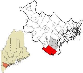
York County is the southwesternmost county in the U.S. state of Maine, along the state of New Hampshire's eastern border. It is divided from Strafford County, New Hampshire, by the Salmon Falls River and the connected tidal estuary, the Piscataqua River. York County was permanently established in 1639. Several of Maine's earliest colonial settlements are found in the county, which is the state's oldest and one of the oldest in the United States. As of the 2020 census, its population was 211,972, making it Maine's second-most populous county. Its county seat is Alfred. York County is part of the Portland–South Portland, Maine Metropolitan Statistical Area.

<span class="mw-page-title-main">Byron, Maine</span> Town in the state of Maine, United States

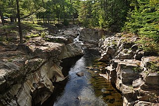
Byron is a town in Oxford County, Maine, United States. The population was 103 at the 2020 census. Home to Coos Canyon on the Swift River, Byron includes the village of Houghton.

<span class="mw-page-title-main">Gilead, Maine</span> Town in the state of Maine, United States

Gilead is a town in Oxford County, Maine, United States. Upon incorporation in 1804, it was named for the large quantity of Balm of Gilead trees in the town center. The population was 195 at the 2020 census.

<span class="mw-page-title-main">Peru, Maine</span> Town in Maine, US

Peru is a town in Oxford County, Maine, United States. Peru is included in the Lewiston-Auburn, Maine metropolitan New England city and town area. The population was 1,488 at the 2020 census.

Woodstock is a town in Oxford County, Maine, United States. Woodstock is included in the Lewiston-Auburn, Maine metropolitan New England city and town area. The population was 1,352 at the 2020 census. The village of Bryant Pond, on State Route 26 in the northern part of Woodstock, is the town's urban center and largest settlement.

<span class="mw-page-title-main">Robbinston, Maine</span> Town in the state of Maine, United States

Robbinston is a town in Washington County, Maine, United States. The population was 539 at the 2020 census.

<span class="mw-page-title-main">Alfred, Maine</span> Town in the state of Maine, United States

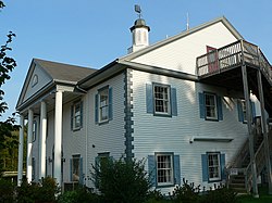
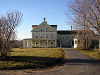
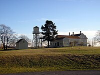
Alfred is a town in York County, Maine, United States. As of the 2020 census, the town population was 3,073. Alfred is the seat of York County, and home to part of the Massabesic Experimental Forest. National Register of Historic Places has two listings in the town, the Alfred Historic District, with 48 houses, and the Alfred Shaker Historic District.

<span class="mw-page-title-main">Arundel, Maine</span> Town in the state of Maine, United States

Arundel is a town in York County, Maine, United States. At the 2020 census, the population was 4,264. It is part of the Portland–South Portland–Biddeford, Maine Metropolitan Statistical Area. The Municipality of Arundel includes the constituent communities and neighbourhoods of: Arundel Village, Vinegar Hill, Riverside Arundel, Log Cabin Crossing, Goff Mill, Millers Crossing, and Cottagehill, among other neighbourhoods in an inland area adjacent to the Towns of Kennebunkport and Biddeford. In 2014, Arundel was named “Best Place to Live in Maine” by Downeast Magazine.

<span class="mw-page-title-main">Dayton, Maine</span> Town in the state of Maine, United States

Dayton is a town in York County, Maine, United States; the town is located near the Saco-Biddeford city area. Dayton borders Biddeford by land, and borders Saco on the Saco River. It is also part of the Portland–South Portland–Biddeford, Maine metropolitan statistical area. The population was 2,129 at the 2020 census. Dayton is one of the smallest towns in York County.

<span class="mw-page-title-main">Limington, Maine</span> Town in the state of Maine, United States

Limington is a town in York County, Maine, United States. The population was 3,892 at the 2020 census. Limington is a tourist destination with historic architecture. It is part of the Portland–South Portland–Biddeford, Maine metropolitan statistical area.

<span class="mw-page-title-main">Lyman, Maine</span> Town in the state of Maine, United States

Lyman is a town in York County, Maine, United States. The population was 4,525 at the 2020 census. It is part of the Portland–South Portland–Biddeford, Maine metropolitan statistical area. Lyman, together with Alfred, is home to Massabesic Experimental Forest.

<span class="mw-page-title-main">Ogunquit, Maine</span> Town in Maine, United States

Ogunquit is a resort town in York County, Maine, United States. As of the 2020 census, its population was 1,577.

<span class="mw-page-title-main">West Kennebunk, Maine</span> Census-designated place in Maine, United States

West Kennebunk is a census-designated place (CDP) in the town of Kennebunk in York County, Maine, United States. The population was 1,176 at the 2010 census. It is part of the Portland–South Portland–Biddeford, Maine Metropolitan Statistical Area.

York is a town in York County, Maine, United States, near the southern tip of the state. The population in the 2020 census was 13,723. Situated beside the Atlantic Ocean on the Gulf of Maine, York is a well-known summer resort town. It is home to three 18-hole golf clubs, four sandy beaches, and Mount Agamenticus. From south to north, it is divided into the villages of Bald Head, York Village, York Harbor, York Beach and Cape Neddick.

<span class="mw-page-title-main">Kennebunk (CDP), Maine</span> Census-designated place in Maine, United States

Kennebunk is a census-designated place (CDP) comprising the central village in the town of Kennebunk in York County, Maine, United States. The population was 5,214 at the 2010 census, out of a total town population of 10,798. It is part of the Portland–South Portland–Biddeford, Maine Metropolitan Statistical Area.

<span class="mw-page-title-main">Kennebunk, Maine</span> Town in Maine, United States

Kennebunk is a town in York County, Maine, United States. The population was 11,536 at the 2020 census. Kennebunk is home to several beaches, the Rachel Carson National Wildlife Refuge, the 1799 Kennebunk Inn, many historic shipbuilders' homes, the Brick Store Museum and the Nature Conservancy Kennebunk Plains, with 1,500 acres (6 km2) of nature trails and blueberry fields.

<span class="mw-page-title-main">Kennebunkport, Maine</span> Town in the state of Maine, United States

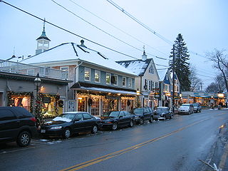
Kennebunkport is a resort town in York County, Maine, United States. The population was 3,629 people at the 2020 census. It is part of the Portland–South Portland–Biddeford metropolitan statistical area.

<span class="mw-page-title-main">Dexter, Maine</span> Town in the state of Maine, United States

Dexter is a town in Penobscot County, Maine, United States. The population was 3,803 at the 2020 census. It is part of the Bangor metropolitan statistical area. Dexter Regional High School, which serves Dexter as well as other nearby small towns, is located in the town.

<span class="mw-page-title-main">Scarborough, Maine</span> Town in the state of Maine, United States

Scarborough is a town in Cumberland County on the southern coast of the U.S. state of Maine. Located about 7 miles (11 km) south of Portland, Scarborough is part of the Portland–South Portland–Biddeford, Maine metropolitan statistical area. The population was 22,135 at the 2020 census, making it the most populous town in Maine.

Unity is a town in Waldo County, Maine, United States. The population was 2,292 at the 2020 census. The town is the service center for the northern portion of Waldo County. Outside of Waldo County, it is best known as the home of the Maine Organic Farmers and Gardeners Association, its Common Ground Country Fair and Unity College. Unity College was founded in 1965 to offset the economic effects of the declining chicken farming industry. As of 2007, the college is the town's largest employer.

References

  1. 1 2 "US Gazetteer files 2010". United States Census Bureau . Retrieved December 16, 2012.
  2. Geo. J. Varney. "History of Wells, Maine." A Gazetteer of the State of Maine, Published by B. B. Russell, 57 Cornhill, Boston 1886. Transcribed by Betsey S. Webber.
  3. "Census - Geography Profile: Wells town, York County, Maine" . Retrieved January 11, 2022.
  4. "America and West Indies: December 1661." Calendar of State Papers Colonial, America and West Indies: Volume 5, 1661-1668. Ed. W Noel Sainsbury. London: Her Majesty's Stationery Office, 1880. 61-66. British History Online [ permanent dead link ] Retrieved March 4, 2019.
  5. 1 2 Coolidge, Austin J.; John B. Mansfield (1859). A History and Description of New England. Boston, Massachusetts: A.J. Coolidge. pp.  349–353. coolidge mansfield history description new england 1859.
  6. Varney, George J. (1886), Gazetteer of the state of Maine. Wells, Boston: Russell
  7. Hagan, Jennifer (January 1, 2004). "Kids Circus fitting finale for celebration". York County Coast Star. Retrieved July 27, 2010.
  8. "Hope M. Shelley, "A History of Wells, Maine". Archived from the original on September 29, 2011. Retrieved January 28, 2011.
  9. "10 things to do in Wells". Archived from the original on May 29, 2014. Retrieved May 28, 2014.
  10. Wells Public Library
  11. databaseFootball.com Archived November 22, 2011, at the Wayback Machine
  12. Davis, Henry Blaine Jr. (1998). Generals in Khaki. Raleigh, NC: Pentland Press. pp. 363–364. ISBN   978-1-5719-7088-6 via Google Books.
  13. "MAINE, Population of Counties by Decennial Census: 1900 to 1990". Archived from the original on February 1, 2016. Retrieved August 4, 2023.
  14. "American FactFinder". Archived from the original on May 20, 2011. Retrieved October 1, 2011.
  15. "University of Virginia Library". mapserver.lib.virginia.edu.
  16. "U.S. Census website". United States Census Bureau . Retrieved December 16, 2012.
  17. "U.S. Census website". United States Census Bureau . Retrieved January 31, 2008.

Further reading