Buxton, Maine

Last updated
Buxton, Maine
Falls on Saco River, West Buxton, ME.jpg
Falls on Saco River c.1908
USA Maine location map.svg
Red pog.svg
Buxton
Location within the state of Maine
Coordinates: 43°38′7″N70°32′21″W / 43.63528°N 70.53917°W / 43.63528; -70.53917
Country United States
State Maine
County York
Incorporated1772
Government
  Type Town Meeting
  ChairmanChad Poitras
  SelectmenDavid Field
Mark J. Blier
Thomas J. Peters
Frank Pulsoni
Area
[1]
  Total52.9 sq mi (106.79 km2)
  Land52.19 sq mi (104.95 km2)
  Water0.71 sq mi (1.84 km2)
Elevation
180 ft (55 m)
Population
 (2020)
  Total8,376
  Density207/sq mi (79.8/km2)
Time zone UTC-5 (Eastern (EST))
  Summer (DST) UTC-4 (EDT)
ZIP code
04093
Area code 207
FIPS code 23-09410
GNIS feature ID0582380
Website www.buxton.me.us

Buxton is a town in York County, Maine, United States. It is part of the Portland metropolitan area. The population was 8,376 at the 2020 census. [2] Buxton includes the villages of Salmon Falls/Tory Hill, Chicopee, Groveville, Bar Mills, West Buxton, and Buxton Center. The old town Common is east of Union Falls, which is the location of Skelton Dam, operated by Central Maine Power, and near historic location of the original settlement at Pleasant Point.

Contents

History

The township was granted by the Massachusetts General Court as Narragansett Number 1 in 1728. It was assigned to Philemon Dane of Ipswich, Massachusetts and 119 other veterans (or their heirs) who had fought in King Philip's War against the Narragansett Indians in 1675. Settlement was attempted in the early 1740s but abandoned because of the ongoing French and Indian Wars. [3]

West Buxton lumber mills, 1919 Mills, West Buxton, ME.jpg
West Buxton lumber mills, 1919

The first permanent settlement commenced in fall of 1750 near Salmon Falls, which was within protection of the stockaded blockhouse and trading post built in 1728 a half mile below Union Falls in present-day Dayton. Amos Chase was one of the pioneers of the town, and his daughter was said to be the first white child born in Buxton. He was a prominent figure in the area, one of the largest taxpayers, and was the first deacon of the Congregational Church in Pepperellborough (present-day Saco, ME). [4] [5] [6] [7] [8] [9] [10] [11] The first schoolhouse in Buxton was established in 1761 by Rev. Silas Moody. Narragansett Number 1 was incorporated in 1772 as Buxton. It was named by its minister, Rev. Paul Coffin for the spa town of Buxton in Derbyshire, England, for unknown reasons. Buxton, England is often incorrectly cited as the home of his ancestors, but that was Brixton as noted on page 7 of the cited source(2). [12]

Settlers found the land generally level and suited for farming. Chief crops were corn, potatoes and hay. Buxton also provided excellent water power sites. The first sawmill was on the Little River, a tributary of the Presumpscot River. A gristmill called Bog Mill was built at the outlet of Bonny Eagle Pond. The biggest mills, however, were located at the series of falls on the Saco River. Salmon Falls had sawmills capable of turning out four million feet of lumber annually. Bar Mills had gristmills and a box mill. Moderation Falls in West Buxton had sawmills, heading mills and woolen textile mills which produced about 936,000 yards of cloth annually. Buxton's mill town prosperity left behind fine architecture. Listed on the National Register of Historic Places are Elden's Store, the Buxton Powder House, the First Congregational Church, Royal Brewster House and Salmon Falls (East) Historic District. [13]

Geography

According to the United States Census Bureau, the town has a total area of 41.23 square miles (106.79 km2), of which 40.52 square miles (104.95 km2) is land and 0.71 square miles (1.84 km2) is water. [1] Buxton is drained by Little River and the Saco River. Bonny Eagle Pond is a 211-acre (0.85 km2) body of water located in the northern part of the town.

Buxton borders the towns of Gorham to the northeast, Scarborough and Saco to the southeast, Dayton to the south, Hollis to the west and Standish to the northwest.

Climate

The climate is humid continental, similar to nearby towns such as Concord, New Hampshire. The Köppen is Dfb.

Climate data for West Buxton (1953–2012 normals)
MonthJanFebMarAprMayJunJulAugSepOctNovDecYear
Record high °F (°C)69
(21)
63
(17)
88
(31)
94
(34)
94
(34)
95
(35)
98
(37)
98
(37)
97
(36)
87
(31)
74
(23)
70
(21)
98
(37)
Average high °F (°C)30.7
(−0.7)
34.1
(1.2)
42.4
(5.8)
54.7
(12.6)
66.4
(19.1)
75.1
(23.9)
79.9
(26.6)
78.5
(25.8)
70.5
(21.4)
59.3
(15.2)
47.0
(8.3)
35.2
(1.8)
56.2
(13.4)
Average low °F (°C)6.8
(−14.0)
8.5
(−13.1)
19.7
(−6.8)
30.3
(−0.9)
40.5
(4.7)
50.6
(10.3)
56.0
(13.3)
54.1
(12.3)
45.8
(7.7)
34.8
(1.6)
26.5
(−3.1)
14.0
(−10.0)
32.3
(0.2)
Record low °F (°C)−34
(−37)
−32
(−36)
−22
(−30)
5
(−15)
20
(−7)
32
(0)
38
(3)
30
(−1)
23
(−5)
12
(−11)
−3
(−19)
−31
(−35)
−34
(−37)
Average precipitation inches (mm)3.38
(86)
3.34
(85)
4.07
(103)
4.27
(108)
3.97
(101)
3.78
(96)
3.64
(92)
3.21
(82)
3.82
(97)
4.47
(114)
4.85
(123)
4.09
(104)
46.89
(1,191)
Average snowfall inches (cm)16.0
(41)
11.4
(29)
8.7
(22)
1.5
(3.8)
0.1
(0.25)
0
(0)
0
(0)
0
(0)
0
(0)
0.2
(0.51)
1.4
(3.6)
11.7
(30)
51
(130.16)
Source: Desert Research Institute [14]

Demographics

Historical population
CensusPop.Note
1790 1,508
1800 1,93828.5%
1810 2,32419.9%
1820 2,59011.4%
1830 2,85510.2%
1840 2,688−5.8%
1850 2,99511.4%
1860 2,853−4.7%
1870 2,546−10.8%
1880 2,230−12.4%
1890 2,036−8.7%
1900 1,838−9.7%
1910 1,675−8.9%
1920 1,560−6.9%
1930 1,5740.9%
1940 1,7088.5%
1950 2,00917.6%
1960 2,33916.4%
1970 3,13534.0%
1980 5,77584.2%
1990 6,49412.5%
2000 7,45214.8%
2010 8,0347.8%
2020 8,3764.3%
[15] [16] [17]

2010 census

As of the census [18] of 2010, there were 8,034 people, 3,108 households, and 2,254 families residing in the town. The population density was 198.3 inhabitants per square mile (76.6/km2). There were 3,301 housing units at an average density of 81.5 per square mile (31.5/km2). The racial makeup of the town was 96.5% White, 0.6% African American, 0.2% Native American, 0.9% Asian, 0.2% from other races, and 1.7% from two or more races. Hispanic or Latino of any race were 0.7% of the population.

There were 3,108 households, of which 32.8% had children under the age of 18 living with them, 58.5% were married couples living together, 9.4% had a female householder with no husband present, 4.6% had a male householder with no wife present, and 27.5% were non-families. Of all households, 19.1% were made up of individuals, and 6.5% had someone living alone who was 65 years of age or older. The average household size was 2.58 and the average family size was 2.94.

The median age in the town was 41.5 years. 22.7% of residents were under the age of 18; 6.7% were between the ages of 18 and 24; 26.1% were from 25 to 44; 32.6% were from 45 to 64; and 12% were 65 years of age or older. The gender makeup of the town was 50.4% male and 49.6% female.

2000 census

As of the census [19] of 2000, there were 7,452 people, 2,804 households, and 2,094 families residing in the town. The population density was 184.0 inhabitants per square mile (71.0/km2). There were 2,930 housing units at an average density of 72.4 per square mile (28.0/km2). The racial makeup of the town was 97.83% White, 0.42% African American, 0.24% Native American, 0.59% Asian, 0.12% Pacific Islander, 0.19% from other races, and 0.62% from two or more races. Hispanic or Latino of any race were 0.55% of the population.

There were 2,804 households, out of which 35.3% had children under the age of 18 living with them, 62.6% were married couples living together, 8.7% had a female householder with no husband present, and 25.3% were non-families. Of all households, 18.0% were made up of individuals, and 5.8% had someone living alone who was 65 years of age or older. The average household size was 2.65 and the average family size was 3.00.

In the town, the population was spread out, with 25.1% under the age of 18, 6.8% from 18 to 24, 33.1% from 25 to 44, 25.5% from 45 to 64, and 9.5% who were 65 years of age or older. The median age was 37 years. For every 100 females, there were 101.1 males. For every 100 females age 18 and over, there were 98.4 males.

The median income for a household in the town was $48,958, and the median income for a family was $52,845. Males had a median income of $35,628 versus $27,400 for females. The per capita income for the town was $20,179. About 3.2% of families and 6.0% of the population were below the poverty line, including 5.1% of those under age 18 and 16.5% of those age 65 or over.

Arts and culture

Sites of interest include the Buxton-Hollis Historical Society and Museum, the Tory Hill Meeting House (1822), Brewster Mansion (1805), and the Powder House (1813).

Notable people

Related Research Articles

<span class="mw-page-title-main">York County, Maine</span> County in Maine, United States

York County is the southwesternmost county in the U.S. state of Maine, along the state of New Hampshire's eastern border. It is divided from Strafford County, New Hampshire, by the Salmon Falls River, and the connected tidal estuary—the Piscataqua River. York County was permanently established in 1639. It is the state's oldest county and one of the oldest in the United States. Several of Maine's earliest colonial settlements are found in the county. As of the 2020 census, its population was 211,972, making it Maine's second-most populous county. Its county seat is Alfred. York County is part of the Portland–South Portland, Maine Metropolitan Statistical Area.

<span class="mw-page-title-main">Baldwin, Maine</span> Town in the state of Maine, United States

Baldwin is a town in Cumberland County, Maine, United States. The population was 1,520 at the 2020 census. It is part of the Portland–South Portland–Biddeford, Maine, metropolitan statistical area.

<span class="mw-page-title-main">Standish, Maine</span> Town in the state of Maine, United States

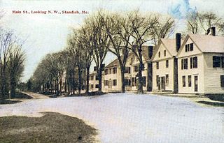
Standish is a town in Cumberland County, Maine, United States. The population was 10,244 at the 2020 census. It includes the villages of Standish Corner, Sebago Lake Village and Steep Falls, and the localities known as Richville, Elmwood, Standish Neck and Two Trails. Standish is part of the Portland-South Portland-Biddeford, Maine metropolitan statistical area.

<span class="mw-page-title-main">Brownfield, Maine</span> Town in the state of Maine, United States

Brownfield is a town in Oxford County, Maine, United States. The population was 1,631 at the 2020 census. Brownfield is home to the Stone Mountain Arts Center.

<span class="mw-page-title-main">Hiram, Maine</span> Town in the state of Maine, United States

Hiram is a town in Oxford County, Maine, United States. The population was 1,609 at the 2020 census. It includes the villages of Hiram, East Hiram, South Hiram and Durgintown. Located among the rugged and unspoiled Western Maine Mountains, Hiram is part of the Portland-South Portland-Biddeford, Maine metropolitan New England city and town area.

<span class="mw-page-title-main">Acton, Maine</span> Town in the state of Maine, United States

Acton is a town in York County, Maine, United States. The population was 2,671 at the 2020 census. It includes the villages of Acton, Miller Corner and South Acton. The town is home to the Acton Fairground, which holds the Acton Fair every late summer. It is part of the Portland–South Portland–Biddeford, Maine metropolitan statistical area.

<span class="mw-page-title-main">Biddeford, Maine</span> City in Maine, United States

Biddeford is a city in York County, Maine, United States. It is the principal commercial center of York County. Its population was 22,552 at the 2020 census. The twin cities of Saco and Biddeford include the resort communities of Biddeford Pool and Fortunes Rocks. The town is the site of the University of New England and the annual La Kermesse Franco-Americaine Festival. First visited by Europeans in 1616, it is the site of one of the earliest European settlements in the United States. It is home to Saint Joseph's Church, the tallest building in Maine.

<span class="mw-page-title-main">Dayton, Maine</span> Town in the state of Maine, United States

Dayton is a town in York County, Maine, United States; the town is located near the Saco-Biddeford city area. Dayton borders Biddeford by land, and borders Saco on the Saco River. It is also part of the Portland–South Portland–Biddeford, Maine metropolitan statistical area. The population was 2,129 at the 2020 census. Dayton is one of the smallest towns in York County.

<span class="mw-page-title-main">Hollis, Maine</span> Town in the state of Maine, United States

Hollis is a town in York County, Maine, United States. The population was 4,745 at the 2020 census. Hollis is a rural bedroom community of Portland and is part of the Portland–South Portland–Biddeford, Maine metropolitan statistical area.

<span class="mw-page-title-main">Lebanon, Maine</span> Town in Maine, United States

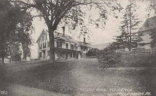
Lebanon is a town in York County, Maine, United States. The population was 6,469 at the 2020 census. Lebanon includes the villages of Center Lebanon, West Lebanon, North Lebanon, South Lebanon, and East Lebanon. It is the westernmost town in Maine. Lebanon is part of the Portland–South Portland–Biddeford, Maine metropolitan statistical area.

<span class="mw-page-title-main">Limerick, Maine</span> Town in Maine, United States

Limerick is a town in York County, Maine, United States. It is part of the Portland–South Portland–Biddeford, Maine metropolitan statistical area. The population was 3,188 at the 2020 census.

<span class="mw-page-title-main">Limington, Maine</span> Town in the state of Maine, United States

Limington is a town in York County, Maine, United States. The population was 3,892 at the 2020 census. Limington is a tourist destination with historic architecture. It is part of the Portland–South Portland–Biddeford, Maine metropolitan statistical area.

<span class="mw-page-title-main">Saco, Maine</span> City in Maine, United States

Saco is a city in York County, Maine, United States. The population was 20,381 at the 2020 census. It is home to Ferry Beach State Park, Funtown Splashtown USA, Thornton Academy, as well as General Dynamics Armament Systems, a subsidiary of the defense contractor General Dynamics. Saco sees much tourism during summer months due to its amusement parks, Camp Ellis Beach and Pier, Ferry Beach State Park, and proximity to Old Orchard Beach.

<span class="mw-page-title-main">South Berwick, Maine</span> Town in the state of Maine, United States

South Berwick is a town in York County, Maine, United States. The population was 7,467 at the 2020 census. South Berwick is home to Berwick Academy, a private, co-educational university-preparatory day school founded in 1791.

<span class="mw-page-title-main">Wakefield, New Hampshire</span> Town in New Hampshire, United States

Wakefield is a town in Carroll County, New Hampshire, United States. The population was 5,201 at the 2020 census. The town includes the villages of Wakefield Corner, East Wakefield, North Wakefield, Sanbornville, Union, Woodman and Province Lake. Wakefield Corner, popular with tourists, is a picturesque hilltop village of antique buildings. The state of Maine is on the eastern border of Wakefield.

<span class="mw-page-title-main">Rollinsford, New Hampshire</span> Town in New Hampshire, United States

Rollinsford is a town in Strafford County, New Hampshire, United States. The population was 2,597 at the 2020 census. The main village in town was once known as "Salmon Falls Village".

<span class="mw-page-title-main">North Berwick, Maine</span> Town in Maine, United States

North Berwick is a town in York County, Maine, United States. The town was set off from Berwick in 1831, following South Berwick in 1814.

<span class="mw-page-title-main">Milton Mills, New Hampshire</span> Census-designated place in New Hampshire, United States

Milton Mills is a small village and census-designated place in the town of Milton, Strafford County, New Hampshire, United States. It had a population of 313 at the 2020 census. Milton Mills has a separate ZIP code (03852) from the rest of the town of Milton.

<span class="mw-page-title-main">Gorham, Maine</span> Town in the state of Maine, United States

Gorham is a town in Cumberland County, Maine, United States. The population was 18,336 at the 2020 United States Census. In addition to its urban village center known as Gorham Village or simply "the Village," the town encompasses a number of smaller, unincorporated villages and hamlets with distinct historical identities, including South Gorham, West Gorham, Little Falls, White Rock, and North Gorham. Gorham is home to one of the three campuses of the University of Southern Maine. In 2013, Gorham was voted second-best town in Maine after Hampden by a financial website.

<span class="mw-page-title-main">Berwick, Maine</span> Town in the state of Maine, United States

Berwick is a town in York County, Maine, United States, situated in the southern part of the state beside the Salmon Falls River.

References

  1. 1 2 "US Gazetteer files 2010". United States Census Bureau . Retrieved 2012-12-16.
  2. "Census - Geography Profile: Buxton town, York County, Maine" . Retrieved January 11, 2022.
  3. Coolidge, Austin J.; John B. Mansfield (1859). A History and Description of New England. Boston, Massachusetts: A.J. Coolidge. pp.  79–80. coolidge mansfield history description new england 1859.
  4. Chase, Lonnie, “Chase-L Archives,” (http://listsearches.rootsweb.com/th/read/CHASE/2003-01/1043803638 Archived 2011-07-15 at the Wayback Machine ), Retrieved 10 Feb 2011.
  5. ”York County Genealogy and Cemeteries – Buxton History,” (http://www.knights.hls-inc.net/BuxtonHis.htm), Retrieved 10 Feb 2011.
  6. ”Note from the Chase Chronicles,” Oct. 1910 (http://www.webnests.com/Chase/chronicles/amos.htm), Retrieved 10 Feb 2011.
  7. Young, David Colby, “Selected Obits from Eastern Argus Portland, Maine 1825,” 1997, ( "Archived copy". Archived from the original on 2011-01-06. Retrieved 2011-02-10.{{cite web}}: CS1 maint: archived copy as title (link)) Retrieved 10 Feb 2011.
  8. Ridlon Sr., G. T. Saco Valley Settlements and Families: Historical, Biographical, Genealogical, Traditional, and Legendary, Portland, ME, 1895, pp.105-6.
  9. Owen, Daniel Edward. Old Times in Saco, 1891, pp. 56, 70, 151.
  10. Folsom, George. History of Saco and Biddeford, Alex. C. Putnam, 1830, pp. 265-7, 276, 281.
  11. Records of the Proprietors of Narraganset Township No. 1, Now the Town of Buxton, York County, Maine, August 1, 1733 to January 4, 1811, privately printed, Concord, NH, 1871, pp. 142, 147, 175, 185, 224, 253, 269-77(https://books.google.com/books?id=k1pAAAAAYAAJ&pg=PA188&lpg=PA188&dq=narragansett+no.+1&source=bl&ots=ZyfjoVybQ5&sig=MvgwPVAdySorH3ijz5z1RRttaho&hl=en&sa=X&ei=SJtcU_yzDKKf2QWn44D4CQ&ved=0CDkQ6AEwAg#v=onepage&q=narragansett%20no.%201&f=false).
  12. Paul Coffin, The Memoir and Journals of Rev. Paul Coffin, 1855
  13. "History of Buxton, Maine". history.rays-place.com.
  14. "Desert Research Institute".
  15. https://www.census.gov/population/www/censusdata/cencounts/files/me190090.txt [ bare URL plain text file ]
  16. "American FactFinder". Archived from the original on 2011-05-20. Retrieved 2015-11-03.
  17. "University of Virginia Library". mapserver.lib.virginia.edu.
  18. "U.S. Census website". United States Census Bureau . Retrieved 2012-12-16.
  19. "U.S. Census website". United States Census Bureau . Retrieved 2008-01-31.