Berwick, Maine

Last updated

Berwick, Maine
View of Sullivan Square, Berwick, ME.jpg
Sullivan Square in 1907
Nickname: 
The Berwicks
Motto: 
Where Tradition Meets Tomorrow
USA Maine location map.svg
Red pog.svg
Berwick
Location within the state of Maine
Coordinates: 43°16′2″N70°51′42″W / 43.26722°N 70.86167°W / 43.26722; -70.86167
CountryUnited States
State Maine
County York
Incorporated 1713
Government
  TypeTown Manager Plan [1]
  ChairNoah Cobb
  Vice-ChairLinda Corliss
  SelectmenThomas Wright
Mike Laterreur
Lisa Chase
Area
[2]
  Total37.86 sq mi (98.06 km2)
  Land37.52 sq mi (97.18 km2)
  Water0.34 sq mi (0.88 km2)
Elevation
338 ft (103 m)
Population
 (2020)
  Total7,950
  Density212/sq mi (81.8/km2)
Time zone UTC−5 (Eastern (EST))
  Summer (DST) UTC−4 (EDT)
ZIP Code
03901
Area code 207
FIPS Code23-23031
Website www.berwickmaine.org

Berwick is a town in York County, Maine, United States, situated in the southern part of the state beside the Salmon Falls River.

Contents

Today's South Berwick was set off from Berwick in 1814, while North Berwick was partitioned from the town in 1831.

The population was 7,950 at the 2020 census. [3] It is part of the PortlandSouth PortlandBiddeford, Maine metropolitan statistical area.

History

Originally part of Kittery, the area later comprised by Berwick was settled about 1631 and called Kittery Commons or Kittery North Parish. It was later called Unity after the ship that transported Scots prisoners of war from the Battle of Dunbar in 1650 to the colonies. These Scots had been force-marched to Durham Cathedral in Durham, England, then tried for treason for supporting Charles II rather than Oliver Cromwell, Lord Protector. [4] Many settled near Berwick in an area near the northern Eliot-York border, which came to be known—and still is—as Scotland Bridge. [5]

Landing in Massachusetts, the royalist soldiers were sold as indentured servants, many of whom went to work at the Great Works sawmill, located on the Great Works River, until they were able to pay for their own freedom. (George Gray, formerly of Lanark, Scotland, was an example of the 150 prisoners who endured this ordeal. In 1675, he defended his family and lands when the community was attacked during King Philip's War, and died in Unity in 1693. His descendants would populate other areas of Maine, notably Deer Isle and Stonington, Maine).

The raid by Indians in 1675 was the first of several during what was known as King Philip's War. In 1690–1691 during King William's War, the village was burned and abandoned in the Raid on Salmon Falls. It was resettled in 1703 and called Newichawannock, its old Abenaki name. In 1713, it was incorporated by the Massachusetts General Court as Berwick, after Berwick-upon-Tweed, England. The first schoolhouse in the state was built here in 1719. The town was raided numerous times during Father Rale's War. Berwick was once considerably larger in size, but South Berwick was set off in 1814, followed by North Berwick in 1831. Lumbering was a principal early industry. The first lumber exported from the American colonies was clapboards and barrel staves loaded aboard Pied Cowe at South Berwick in 1634. [6] Beginning in the 19th century, Berwick had a symbiotic economic relationship with Somersworth, New Hampshire, the mill town to which it is connected by bridge. [7]

Geography

According to the United States Census Bureau, the town has a total area of 37.86 square miles (98.06 km2), of which 37.52 square miles (97.18 km2) is land and 0.34 square miles (0.88 km2) is water. [2] Berwick is drained by the Little River and Salmon Falls River. Diamond Hill, at an elevation of 490 feet (149.4 m) above sea level, is the town's highest point. The lowest elevation, which is approximately 70 feet (21.3 m) above sea level, is on the Salmon River as it crosses the southernmost town border with South Berwick.

The town is served by state routes 9 and 236.

Climate

This climatic region is typified by large seasonal temperature differences, with warm to hot (and often humid) summers and cold (sometimes severely cold) winters. According to the Köppen Climate Classification system, Berwick has a humid continental climate, abbreviated "Dfb" on climate maps. [8]

Demographics

Historical population
CensusPop.Note
1790 3,894
1800 3,891−0.1%
1810 4,45514.5%
1820 2,736−38.6%
1830 3,16815.8%
1840 1,698−46.4%
1850 2,12124.9%
1860 2,1551.6%
1870 2,2916.3%
1880 2,77421.1%
1890 2,294−17.3%
1900 2,280−0.6%
1910 2,098−8.0%
1920 2,057−2.0%
1930 1,961−4.7%
1940 1,9710.5%
1950 2,1669.9%
1960 2,73826.4%
1970 3,13614.5%
1980 4,14932.3%
1990 5,99544.5%
2000 6,3536.0%
2010 7,24614.1%
2020 7,9509.7%
[9] [10] [11]

2000 census

As of the census [12] of 2000, there were 6,353 people, 2,319 households, and 1,723 families residing in the town. The population density was 171.1 inhabitants per square mile (66.1/km2). There were 2,414 housing units at an average density of 65.0 per square mile (25.1/km2). The racial makeup of the town was 97.31% White, 0.36% Black or African American, 0.14% Native American, 1.16% Asian, 0.03% Pacific Islander, 0.06% from other races, and 0.93% from two or more races. Hispanic or Latino of any race were 0.54% of the population.

There were 2,319 households, out of which 40.3% had children under the age of 18 living with them, 59.0% were married couples living together, 11.0% had a female householder with no husband present, and 25.7% were non-families. 20.4% of all households were made up of individuals, and 7.2% had someone living alone who was 65 years of age or older. The average household size was 2.72 and the average family size was 3.15.

In the town, the population was spread out, with 29.1% under the age of 18, 7.6% from 18 to 24, 32.5% from 25 to 44, 21.2% from 45 to 64, and 9.5% who were 65 years of age or older. The median age was 36 years. For every 100 females, there were 95.8 males. For every 100 females age 18 and over, there were 94.6 males.

The median income for a household in the town was $44,629, and the median income for a family was $53,776. Males had a median income of $36,329 versus $24,911 for females. The per capita income for the town was $18,988. About 6.9% of families and 8.3% of the population were below the poverty line, including 9.0% of those under age 18 and 15.9% of those age 65 or over.

2010 census

As of the census [12] of 2010, there were 7,246 people, 2,749 households, and 2,029 families residing in the town. The population density was 193.1 inhabitants per square mile (74.6/km2). There were 2,934 housing units at an average density of 78.2 per square mile (30.2/km2). The racial makeup of the town was 96.2% White, 0.5% African American, 0.2% Native American, 1.3% Asian, 0.2% from other races, and 1.6% from two or more races. Hispanic or Latino of any race were 1.3% of the population.

There were 2,749 households, of which 36.9% had children under the age of 18 living with them, 58.1% were married couples living together, 10.7% had a female householder with no husband present, 5.0% had a male householder with no wife present, and 26.2% were non-families. 20.6% of all households were made up of individuals, and 6.6% had someone living alone who was 65 years of age or older. The average household size was 2.62 and the average family size was 3.01.

The median age in the town was 39.1 years. 25.2% of residents were under the age of 18; 6.7% were between the ages of 18 and 24; 26.9% were from 25 to 44; 30.1% were from 45 to 64; and 11% were 65 years of age or older. The gender makeup of the town was 49.4% male and 50.6% female.

Notable people

Schools

Berwick Maine is part of MSAD60/RSU 60.

There are three schools in Berwick:

Students in grades 8–12 from Berwick attend Noble High School in the neighboring town of North Berwick.

Downtown revitalization

The Town of Berwick was awarded several Brownfield grants in 2015, 2016 and 2017 to help with a downtown revitalization effort. [13] On October 31, 2019, Great Falls Construction purchased the property [14] and over the years has developed the site into The Edge at Berwick Maine.

Related Research Articles

<span class="mw-page-title-main">York County, Maine</span> County in Maine, United States

York County is the southwesternmost county in the U.S. state of Maine, along the state of New Hampshire's eastern border. It is divided from Strafford County, New Hampshire, by the Salmon Falls River and the connected tidal estuary, the Piscataqua River. York County was permanently established in 1639. Several of Maine's earliest colonial settlements are found in the county, which is the state's oldest and one of the oldest in the United States. As of the 2020 census, its population was 211,972, making it Maine's second-most populous county. Its county seat is Alfred. York County is part of the Portland–South Portland, Maine Metropolitan Statistical Area.

<span class="mw-page-title-main">Island Falls, Maine</span> Town in the state of Maine, United States

Island Falls is a town in Aroostook County, Maine, United States. The population was 758 at the 2020 census. The primary village of Island Falls in the town is situated at a falls in the West Branch Mattawamkeag River.

<span class="mw-page-title-main">Roxbury, Maine</span> Town in the state of Maine, United States

Roxbury is a town in Oxford County, Maine, United States. The population was 361 at the 2020 census. Ellis Pond is popular with recreational fishermen.

Beddington is a town in Washington County, Maine, United States. The population was 60 at the 2020 census. It is the third-smallest organized town in Maine after Frye Island and Frenchboro.

<span class="mw-page-title-main">Columbia Falls, Maine</span> Town in the state of Maine, United States

Columbia Falls is a town in Washington County, Maine, United States. The population was 476 at the 2020 census.

<span class="mw-page-title-main">Acton, Maine</span> Town in the state of Maine, United States

Acton is a town in York County, Maine, United States. The population was 2,671 at the 2020 census. It includes the villages of Acton, Miller Corner and South Acton. The town is home to the Acton Fairground, which holds the Acton Fair every late summer. It is part of the Portland–South Portland–Biddeford, Maine metropolitan statistical area.

<span class="mw-page-title-main">Buxton, Maine</span> Town in Maine, United States

Buxton is a town in York County, Maine, United States. It is part of the Portland metropolitan area. The population was 8,376 at the 2020 census. Buxton includes the villages of Salmon Falls/Tory Hill, Chicopee, Groveville, Bar Mills, West Buxton, and Buxton Center. The old town Common is east of Union Falls, which is the location of Skelton Dam, operated by Central Maine Power, and near historic location of the original settlement at Pleasant Point.

<span class="mw-page-title-main">Eliot, Maine</span> Town in Maine, United States

Eliot is a town in York County, Maine, United States. Originally settled in 1623, it was formerly a part of Kittery, to its east. After Kittery, it is the next most southern town in the state of Maine, lying on the Piscataqua River across from Portsmouth and Newington, New Hampshire. The population was 6,717 at the 2020 census. It is part of the Portland–South Portland–Biddeford, Maine metropolitan statistical area.

<span class="mw-page-title-main">Hollis, Maine</span> Town in the state of Maine, United States

Hollis is a town in York County, Maine, United States. The population was 4,745 at the 2020 census. Hollis is a rural bedroom community of Portland and is part of the Portland–South Portland–Biddeford metropolitan statistical area.

<span class="mw-page-title-main">Lebanon, Maine</span> Town in Maine, United States

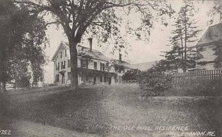
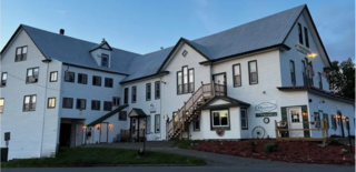
Lebanon is a town in York County, Maine, United States. The population was 6,469 at the 2020 census. Lebanon includes the villages of Center Lebanon, West Lebanon, North Lebanon, South Lebanon, and East Lebanon. It is the westernmost town in Maine. Lebanon is part of the Portland–South Portland–Biddeford, Maine metropolitan statistical area.

<span class="mw-page-title-main">Limerick, Maine</span> Town in Maine, United States

Limerick is a town in York County, Maine, United States. It is part of the Portland–South Portland–Biddeford, Maine metropolitan statistical area. The population was 3,188 at the 2020 census.

<span class="mw-page-title-main">South Berwick, Maine</span> Town in the state of Maine, United States

South Berwick is a town in York County, Maine, United States. The population was 7,467 at the 2020 census. South Berwick is home to Berwick Academy, a private, co-educational university-preparatory day school founded in 1791.

<span class="mw-page-title-main">Wakefield, New Hampshire</span> Town in New Hampshire, United States

Wakefield is a town in Carroll County, New Hampshire, United States. The population was 5,201 at the 2020 census. The town includes the villages of Wakefield Corner, East Wakefield, North Wakefield, Sanbornville, Union, Woodman and Province Lake. Wakefield Corner, popular with tourists, is a picturesque hilltop village of antique buildings. The state of Maine forms the eastern border of Wakefield.

<span class="mw-page-title-main">Rollinsford, New Hampshire</span> Town in New Hampshire, United States

Rollinsford is a town in Strafford County, New Hampshire, United States. The population was 2,597 at the 2020 census. The main village in town was once known as "Salmon Falls Village".

<span class="mw-page-title-main">Somersworth, New Hampshire</span> City in New Hampshire, United States

Somersworth is a city in Strafford County, New Hampshire, United States. The population was 11,855 at the 2020 census. Somersworth has the smallest area and third-lowest population of New Hampshire's 13 cities.

<span class="mw-page-title-main">Kittery (CDP), Maine</span> Census-designated place in Maine, United States

Kittery is a census-designated place (CDP) consisting of the main village in the town of Kittery in York County, Maine, United States. The village is also known as Kittery Foreside. The population of the CDP was 4,562 at the 2010 census. It is part of the Portland–South Portland–Biddeford, Maine Metropolitan Statistical Area.

<span class="mw-page-title-main">Kittery, Maine</span> Town in the state of Maine, United States

Kittery is a town in York County, Maine, United States, and the oldest incorporated town in Maine. Home to the Portsmouth Naval Shipyard on Seavey's Island, Kittery includes Badger's Island, the seaside district of Kittery Point, and part of the Isles of Shoals. The southernmost town in the state, it is a tourist destination known for its many outlet stores.

<span class="mw-page-title-main">North Berwick (CDP), Maine</span> Census-designated place in Maine, United States

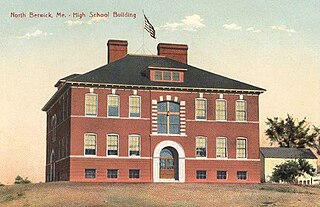
North Berwick is a census-designated place (CDP) consisting of the primary settlement in the town of North Berwick in York County, Maine, United States. The population was 1,615 at the 2010 census, out of a total town population of 4,576. It is part of the Portland–South Portland–Biddeford, Maine Metropolitan Statistical Area.

<span class="mw-page-title-main">North Berwick, Maine</span> Town in Maine, United States

North Berwick is a town in York County, Maine, United States. The town was set off from Berwick in 1831, following South Berwick in 1814.

<span class="mw-page-title-main">Berwick (CDP), Maine</span> Census-designated place in Maine, United States

Berwick is a census-designated place (CDP) in the town of Berwick in York County, Maine, United States. The population was 2,187 at the 2010 census, out of a total of 7,246 in the entire town. It is part of the Portland–South Portland–Biddeford, Maine Metropolitan Statistical Area.

References

  1. "Town Manager" . Retrieved September 4, 2012.
  2. 1 2 "US Gazetteer files 2010". United States Census Bureau . Retrieved December 16, 2012.
  3. "Census - Geography Profile: Berwick town, York County, Maine" . Retrieved January 12, 2022.
  4. Coolidge, Austin J.; John B. Mansfield (1859). A History and Description of New England, General and Local. Boston: Austin J. Coolidge. pp.  53–54.
  5. Scottish Prisoners of 1650 - Old Berwick Historical Society
  6. "The Northern: The Way I Remember" (PDF). John E. Mcleod. Archived from the original (PDF) on August 13, 2013. Retrieved December 19, 2012.
  7. Varney, George J. (1886), Gazetteer of the state of Maine. Berwick, Boston: Russell
  8. Climate Summary for Berwick, Maine
  9. Forstall, Richard L., ed. (March 27, 1995). "Population of Counties by Decennial Census: 1900 to 1990". Washington, DC: US Bureau of the Census. Archived from the original (TXT) on April 20, 2020. Retrieved December 22, 2023.
  10. "American FactFinder". Archived from the original on May 20, 2011. Retrieved July 25, 2012.
  11. "Historical Census Browser". University of Virginia Library . Archived from the original on July 13, 2016. Retrieved December 22, 2023.
  12. 1 2 "U.S. Census Bureau Homepage". United States® Census Bureau . Retrieved December 22, 2023.[ not specific enough to verify ]
  13. EPA (December 29, 2015). "Maine Brownfield Funding History".
  14. "New owner pledges to transform former tannery site in Berwick". November 4, 2019.