Lake Tapawingo, Missouri

Last updated

Lake Tapawingo, Missouri
Jackson County Missouri Incorporated and Unincorporated areas Lake Tapawingo Highlighted.svg
Location of Lake Tapawingo, Missouri
Coordinates: 39°1′11″N94°18′34″W / 39.01972°N 94.30944°W / 39.01972; -94.30944
Country United States
State Missouri
County Jackson
Area
[1]
  Total0.45 sq mi (1.17 km2)
  Land0.32 sq mi (0.83 km2)
  Water0.13 sq mi (0.34 km2)
Elevation
850 ft (259 m)
Population
 (2020)
  Total794
  Density2,481.25/sq mi (957.67/km2)
Time zone UTC-6 (Central (CST))
  Summer (DST) UTC-5 (CDT)
ZIP code
64015
Area code 816
FIPS code 29-40196 [2]
GNIS feature ID0755426 [3]
[4]

Lake Tapawingo is a city in Jackson County, Missouri, United States. The population was 730 at the 2010 census.

Contents

History

Lake Tapawingo was constructed by the Lake Tapawingo Development Company in 1926 as an "exclusive sports retreat and rest haven". [5] The city was named after a lake within its borders. Derived from a Native American word meaning "beautiful water" or "beautiful place", it is also said to be named after a Native American princess. [6] The City of Lake Tapawingo was officially formed in 1962 to prevent annexation by the larger cities of either Blue Springs, Missouri or Independence, Missouri. [7]

Geography

According to the United States Census Bureau, the city has a total area of 0.50 square miles (1.29 km2), of which 0.37 square miles (0.96 km2) is land and 0.13 square miles (0.34 km2) is water. [8]

Demographics

Historical population
CensusPop.Note
1970 867
1980 9256.7%
1990 761−17.7%
2000 84310.8%
2010 730−13.4%
2020 7948.8%
U.S. Decennial Census [9]

2010 census

As of the census [10] of 2010, there were 730 people, 342 households, and 247 families residing in the city. The population density was 1,973.0 inhabitants per square mile (761.8/km2). There were 377 housing units at an average density of 1,018.9 per square mile (393.4/km2). The racial makeup of the city was 96.2% White, 0.7% African American, 0.5% Native American, 0.5% Asian, and 2.1% from two or more races. Hispanic or Latino of any race were 1.8% of the population.

There were 342 households, of which 18.1% had children under the age of 18 living with them, 62.0% were married couples living together, 7.3% had a female householder with no husband present, 2.9% had a male householder with no wife present, and 27.8% were non-families. 23.7% of all households were made up of individuals, and 9.6% had someone living alone who was 65 years of age or older. The average household size was 2.13 and the average family size was 2.45.

The median age in the city was 54.9 years. 11.2% of residents were under the age of 18; 5% were between the ages of 18 and 24; 16.8% were from 25 to 44; 42.4% were from 45 to 64; and 24.8% were 65 years of age or older. The gender makeup of the city was 48.5% male and 51.5% female.

2000 census

Lake Tapawingo, Missouri MOMap-doton-Lake Tapawingo.png
Lake Tapawingo, Missouri

As of the census [2] of 2000, there were 843 people, 350 households, and 259 families residing in the city. The population density was 2,454.6 inhabitants per square mile (947.7/km2). There were 373 housing units at an average density of 1,086.1 per square mile (419.3/km2). The racial makeup of the city was 97.98% White, 0.12% Asian, 0.71% from other races, and 1.19% from two or more races. Hispanic or Latino of any race were 2.25% of the population.

There were 350 households, out of which 22.3% had children under the age of 18 living with them, 67.7% were married couples living together, 4.6% had a female householder with no husband present, and 26.0% were non-families. 20.6% of all households were made up of individuals, and 6.9% had someone living alone who was 65 years of age or older. The average household size was 2.41 and the average family size was 2.79.

In the city the population was spread out, with 19.6% under the age of 18, 5.5% from 18 to 24, 20.5% from 25 to 44, 38.2% from 45 to 64, and 16.3% who were 65 years of age or older. The median age was 47 years. For every 100 females, there were 99.3 males. For every 100 females age 18 and over, there were 96.0 males.

The median income for a household in the city was $73,500, and the median income for a family was $77,493. Males had a median income of $52,708 versus $31,518 for females. The per capita income for the city was $32,141. About 2.6% of families and 3.3% of the population were below the poverty line, including 5.5% of those under age 18 and 2.4% of those age 65 or over.

Education

Lake Tapawingo is served by the Blue Springs R-IV School District.

Related Research Articles

<span class="mw-page-title-main">Savannah, Missouri</span> City in Missouri, United States

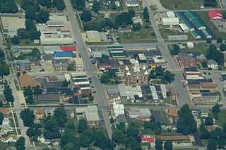
Savannah is a city and county seat of Andrew County, Missouri, United States. The population was 5,069 at the 2020 census.

<span class="mw-page-title-main">Lake Winnebago, Missouri</span> City in Missouri, United States

Lake Winnebago is a city in Cass County, Missouri, United States. The population was 1,131 at the 2010 census. It is part of the Kansas City metropolitan area.

<span class="mw-page-title-main">Wayland, Missouri</span> City in Missouri, United States

Wayland is a city in Clark County, Missouri, United States. As of the 2020 census, its population was 408. It is part of the Fort Madison–Keokuk, IA-MO Micropolitan Statistical Area.

<span class="mw-page-title-main">Berger, Missouri</span> City in Missouri, United States

Berger is a city in northwest Franklin County, Missouri, United States, located south of the Missouri River. The population was 256 at the 2020 census.

<span class="mw-page-title-main">Laredo, Missouri</span> City in Missouri, United States

Laredo is a city in Grundy County, Missouri, United States. The population was 156 at the 2020 census. Laredo is pronounced "la-read-oh" which varies from the traditional pronunciation.

<span class="mw-page-title-main">Big Lake, Missouri</span> Village in Missouri, United States

Big Lake is a village in Holt County, Missouri, United States. The population was 65 at the 2020 census.

<span class="mw-page-title-main">Asbury, Missouri</span> City in Missouri, United States

Asbury is a city in Jasper County, Missouri, United States. The population was 193 at the 2020 census. It is part of the Joplin, Missouri Metropolitan Statistical Area.

<span class="mw-page-title-main">Linneus, Missouri</span> City in Missouri, United States

Linneus is a small city in Linn County, Missouri, United States. The population was 281 at the 2020 census. It is the county seat of Linn County.

<span class="mw-page-title-main">Hayti Heights, Missouri</span> City in Missouri, United States

Hayti Heights is a city in eastern Pemiscot County in the bootheel of southeast Missouri, United States. The population was 515 at the 2020 census.

<span class="mw-page-title-main">Lake Waukomis, Missouri</span> City in Missouri, United States

Lake Waukomis is a city in Platte County, Missouri and is part of the Kansas City metropolitan area within the United States. The population was 888 at the 2020 census.

<span class="mw-page-title-main">Weatherby Lake, Missouri</span> City in Missouri, United States

Weatherby Lake is a city in Platte County, Missouri and is part of the Kansas City metropolitan area within the United States, which borders Kansas City. The population was 1,723 as of the 2010 census.

<span class="mw-page-title-main">Center, Missouri</span> City in Missouri, United States

Center is a city in Ralls County, Missouri, United States. The population was 528 at the 2020 census. It is part of the Hannibal Micropolitan Statistical Area.

<span class="mw-page-title-main">Crystal Lakes, Missouri</span> City in Missouri, United States

Crystal Lakes is a city in western Ray County, Missouri, and part of the Kansas City metropolitan area within the United States. The population was 390 at the 2020 census.

<span class="mw-page-title-main">Nelson, Missouri</span> City in Missouri, United States

Nelson is a city in Saline County, Missouri, United States. The population was 152 at the 2020 census.

<span class="mw-page-title-main">Bellerive Acres, Missouri</span> City in Missouri, United States

Bellerive Acres is a northern suburban city in St. Louis County, Missouri, United States. The population was 188 at the 2010 census. In April, 2015, the residents voted to change the village of Bellerive to a fourth class city named Bellerive Acres.

<span class="mw-page-title-main">Country Club Hills, Missouri</span> City in Missouri, United States

Country Club Hills is a city in St. Louis County, Missouri, United States. The population was 1,274 at the 2010 census.

<span class="mw-page-title-main">Dudley, Missouri</span> City in Missouri, United States

Dudley is a city in Stoddard County, Missouri, United States. The population was 232 at the 2010 census.

<span class="mw-page-title-main">Merriam Woods, Missouri</span> City in Missouri, United States

Merriam Woods is a city in Taney County, Missouri, United States. The population was 2,006 at the 2020 census. It is part of the Branson, Missouri Micropolitan Statistical Area.

<span class="mw-page-title-main">Clarkson Valley, Missouri</span> City in Missouri, United States

Clarkson Valley is a city in St. Louis County, Missouri, United States. The population was 2,609 at the 2020 census.

<span class="mw-page-title-main">Moline Acres, Missouri</span> City in Missouri, United States

Moline Acres is a city in St. Louis County, Missouri, United States. The population was 2,442 at the 2010 census.

References

  1. "ArcGIS REST Services Directory". United States Census Bureau. Retrieved August 28, 2022.
  2. 1 2 "U.S. Census website". United States Census Bureau . Retrieved January 31, 2008.
  3. "US Board on Geographic Names". United States Geological Survey. October 25, 2007. Retrieved January 31, 2008.
  4. "US Gazetteer files: 2010, 2000, and 1990". United States Census Bureau. February 12, 2011. Retrieved April 23, 2011.
  5. "Lake Tapawingo Country Club". life-on-tap. Retrieved August 15, 2020.
  6. "Jackson County Place Names, 1928–1945 (archived)". The State Historical Society of Missouri. Archived from the original on June 24, 2016. Retrieved October 16, 2016.{{cite web}}: CS1 maint: bot: original URL status unknown (link)
  7. "About Us". Lake Tapawingo City Government. August 15, 2020.
  8. "US Gazetteer files 2010". United States Census Bureau. Archived from the original on July 2, 2012. Retrieved July 8, 2012.
  9. "Census of Population and Housing". Census.gov. Retrieved June 4, 2015.
  10. "U.S. Census website". United States Census Bureau . Retrieved July 8, 2012.