
The River Teme rises in Mid Wales, south of Newtown, and flows southeast roughly forming the border between England and Wales for several miles through Knighton before becoming fully English in the vicinity of Bucknell and continuing east to Ludlow in Shropshire, then to the north of Tenbury Wells on the Shropshire/Worcestershire border there, on its way to join the River Severn south of Worcester. The whole of the River Teme was designated as an SSSI, by English Nature, in 1996.

The A49 is an A road in western England, which traverses the Welsh Marches region. It runs north from Ross-on-Wye in Herefordshire via Hereford, Leominster, Ludlow, Shrewsbury and Whitchurch, then continues through central Cheshire to Warrington and Wigan before terminating at its junction with the A6 road just south of Bamber Bridge, near the junction of the M6, M65 and M61 motorways.

The River Clun runs mostly through Shropshire, England and joins the River Teme at Leintwardine, Herefordshire. The Clun Valley is part of the Shropshire Hills AONB.

The name Rea Brook can refer to either of two brooks in Shropshire, England.

Anchor is a remote hamlet in southwest Shropshire, England. The hamlet is the most westerly place in Shropshire.

The Shropshire Hills area, in the English county of Shropshire, is designated as an Area of Outstanding Natural Beauty (AONB). It is located in the south of the county, extending to its border with Wales. Designated in 1958, the area encompasses 802 square kilometres (310 sq mi) of land primarily in south-west Shropshire, taking its name from the upland region of the Shropshire Hills. The A49 road and Welsh Marches Railway Line bisect the area north-south, passing through or near Shrewsbury, Church Stretton, Craven Arms and Ludlow.

Titterstone Clee Hill, sometimes referred to as Titterstone Clee or, incorrectly, Clee Hill, is a prominent hill in the rural English county of Shropshire, rising at the summit to 533 metres (1,749 ft) above sea level.

Known as the Hagley Road in Birmingham, the A456 is a main road in England running between Central Birmingham and Woofferton, Shropshire, south of Ludlow. Some sections of the route, for example Edgbaston near Bearwood, are also the route of the Elan Aqueduct which carries Birmingham's water supply from the Elan Valley.
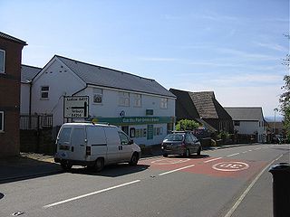
Cleehill is a village in south Shropshire, England. It is sometimes written as Clee Hill Village to avoid confusion. It lies in the civil parish of Caynham. The market towns of Ludlow and Cleobury Mortimer are both 5.5 miles (8.9 km) distant, Ludlow to the west and Cleobury to the east.
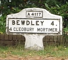
The A4117 is a single-carriageway 'A road' in western England, largely in Shropshire, which passes through part of the Wyre Forest and Clee Hills.

Little Hereford is a small village and civil parish in Herefordshire, England. The civil parish includes the hamlet of Middleton. The population of the civil parish at the 2011 census was 394.

The Shropshire Hills is an upland area and one of the natural regions of England. They lie wholly within the county of Shropshire and encompass several distinctive and well-known landmarks, such as the Long Mynd, Wenlock Edge, The Wrekin and the Clees.

Burford is a village and civil parish in Shropshire, England.
Ludford is a small village and civil parish in south Shropshire, England. The parish is situated adjacent to the market town of Ludlow and was, until 1895, partly in Herefordshire.

Sheet is a small modern village in the parish of Ludford about 1 mile (1.6 km) from the town centre of Ludlow, Shropshire.
The A4113 road is a single-carriageway road that runs from Knighton in Powys to Bromfield in Shropshire, United Kingdom, passing through north Herefordshire.

The River Onny is a river in Shropshire, England. It is a major tributary of the River Teme.

Caynham is a village and civil parish in south Shropshire, England. The parish lies on the River Teme. It can be accessed via the A4117 or the A49 roads and is located 2½ miles (4 km) southeast of the market town of Ludlow. The civil parish includes the village of Cleehill and has an area of 953 hectares.

Greete is a hamlet and civil parish in Shropshire, England.
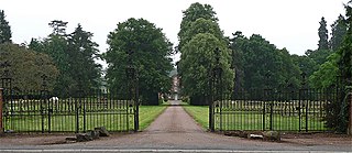
Henley Hall is a building of historical significance and is listed on the English Heritage Register. It was built in about 1610 by the Powys family and then substantially changed in 1772. Additions were again made in the late 19th century. It is a generally a three-storey building in brick with a slate roof. Flanking wings were added at both ends of the original linear building c. 1772 and further major extensions carried out in 1875 and 1907. The hall is surrounded by landscaped and formal gardens covering some 60 hectares. The hall itself is listed grade II* and the orangery, outbuildings, dovecote and Bitterley main gate are listed Grade II. It is situated 2.5 miles (4.0 km) northeast of Ludlow town centre, just off the A4117 road to Cleobury Mortimer. The Ledwyche Brook flows by the estate.
