Kinuso is a hamlet in northern Alberta, Canada within Big Lakes County, and surrounded by the Swan River First Nation reserve. It is located approximately 48 kilometres (30 mi) west of Slave Lake and 71 km east of High Prairie along Highway 2, south of the southern shore of Lesser Slave Lake.

The Digital Himalaya project was established in December 2000 by Mark Turin, Alan Macfarlane, Sara Shneiderman, and Sarah Harrison. The project's principal goal is to collect and preserve historical multimedia materials relating to the Himalaya, such as photographs, recordings, and journals, and make those resources available over the internet and offline, on external storage media. The project team have digitized older ethnographic collections and data sets that were deteriorating in their analogue formats, so as to protect them from deterioration and make them available and accessible to originating communities in the Himalayan region and a global community of scholars.

Ontario, one of the 13 provinces and territories of Canada, is located in east-central Canada. It is Canada's most populous province by a large margin, accounting for nearly 40 per cent of all Canadians, and is the second-largest province in total area. Ontario is fourth-largest in total area when the territories of the Northwest Territories and Nunavut are included. It is home to the nation's capital city, Ottawa, and the nation's most populous city, Toronto.
Robb is a hamlet in west-central Alberta, Canada within Yellowhead County that is recognized as a designated place by Statistics Canada. It is located on Highway 47, approximately 53 kilometres (33 mi) southwest of Edson. It has an elevation of 1,140 metres (3,740 ft).
Marlboro is a hamlet in west-central Alberta, Canada within Yellowhead County. It is located on the Yellowhead Highway, approximately 25 kilometres (16 mi) west of Edson. Sundance Provincial Park is located northwest of the hamlet.
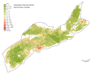
Nova Scotia is a Canadian province located on the country's southeastern coast. It is the most populous province in Atlantic Canada, and its capital, Halifax, is a major economic centre of the region. Geographically, Nova Scotia is the second smallest province in Canada, with an area of 52,824.71 km2 (20,395.73 sq mi). As of 2021, it has a population of 969,383 people.

Languages of Nepal, referred to as Nepalese languages in the country's constitution, are the languages having at least an ancient history or origin inside the sovereign territory of Nepal spoken by Nepalis. The 2011 national census lists 123 languages spoken as a mother tongue in Nepal. Most belong to the Indo-Aryan and Sino-Tibetan language families.
The 1991 Nepal census was a widespread national census conducted by the Nepal Central Bureau of Statistics.
Eaglesham is a hamlet in northern Alberta, Canada within Birch Hills County, located 6 kilometres (3.7 mi) north of Highway 49, approximately 89 kilometres (55 mi) northeast of Grande Prairie.
Nepal conducted a widespread national census in 2011 by the Nepal Central Bureau of Statistics. Working with the 58 municipalities and the 3915 Village Development Committees at a district level, they recorded data from all the municipalities and villages of each district. The data included statistics on population size, households, sex and age distribution, place of birth, residence characteristics, literacy, marital status, religion, language spoken, caste/ethnic group, economically active population, education, number of children, employment status, and occupation.
The 2001 Nepal census was conducted by the Nepal Central Bureau of Statistics. According to the census, the population of Nepal in 2001 was 23,151,423. Working with Nepal's Village Development Committees at a district level, they recorded data from all the main towns and villages of each district of Nepal. The data included statistics on population size, households, sex and age distribution, place of birth, residence characteristics, literacy, marital status, religion, language spoken, caste/ethnic group, economically active population, education, number of children, employment status, and occupation.

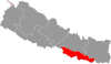
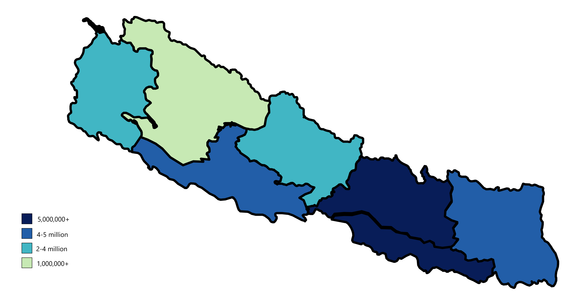
Madhesh Province is a province in southeastern Terai region of Nepal bordering Koshi Pradesh to the east and the north, Bagmati Province to the north, and India’s Bihar state to the south and the west. It has an area of 9,661 km2 (3,730 sq mi) covering about 6.5% of the country's total area. It has a population of 6,126,288 as per the 2021 Nepal census, making it Nepal's most densely populated province and smallest province by area.

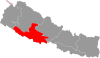
Bagmati Province is one of the seven provinces of Nepal established by the constitution of Nepal. The province is Nepal's second-most populous province and fifth largest province by area. Bagmati is bordered by Tibet Autonomous Region of China to the north, Gandaki Province to the west, Koshi Province to the east, Madhesh Province and the Indian state of Bihar to the south. With Hetauda as its provincial headquarters, the province is also the home to the country's capital Kathmandu, is mostly hilly and mountainous, and hosts mountain peaks including Gaurishankar, Langtang, Jugal, and Ganesh.

Gandaki Province ), is one of the seven federal provinces established by the current constitution of Nepal which was promulgated on 20 September 2015. Pokhara is the province's capital city. It borders the Tibet Autonomous Region of China to the north, Bagmati Province to the east, Karnali Province to the west, and Lumbini Province and Bihar of India to the south. The total area of the province is 21,504 km2 - about 14.57% of the country's total area. According to the latest census, the population of the province was 2,479,745. The newly elected Provincial Assembly adopted Gandaki Province as the permanent name by replacing its initial name Province no. 4 in July 2018. Surendra Raj Pandey is the present chief minister of Gandaki Province.

Karnali Province is one of the seven federal provinces of Nepal formed by the new constitution which was adopted on 20 September 2015. The total area of the province is 27,984 square kilometres (10,805 sq mi) covering 18.97% of the country, making it the largest province in Nepal. According to the 2011 Nepal census, the population of the province was 1,570,418, making it the least populous province in Nepal. It borders the Tibet Autonomous Region of China to the north, Gandaki Province to the east, Sudurpashchim Province to the west, and Lumbini Province to the south. Birendranagar with a population of 154,886 is both the province's capital and largest city.

Sudurpashchim Province is one of the seven provinces established by the new constitution of Nepal which was adopted on 20 September 2015. It borders the Tibet Autonomous Region of China to the north, Karnali Province and Lumbini Province to the east, and the India's Uttarakhand to the west and Uttar Pradesh to the south. The province covers an area of 19,539 km2, or about 13.22% of the country's total area. Initially known as Province No. 7, the newly elected Provincial Assembly adopted Sudurpashchim Province as the permanent name for the province in September 2018. As per a 28 September 2018 Assembly voting, the city of Godawari has been declared the capital of the Province, But till now Dhangadhi serves as the temporary capital. The province is coterminous with the former Far-Western Development Region, Nepal. The three major cities in terms of population and economy are Dhangadhi, Bhimdutta (Mahendranagar), and Tikapur.