List of highest counties in the United States

Last updated
Counties and county-equivalents of the United States of America. Usa counties large.svg
Counties and county-equivalents of the United States of America.

The following table ranks the 50 highest United States counties or county-equivalents [lower-alpha 1] by mean elevation. [lower-alpha 2] This list uses the "mean of extremes" elevation which is the arithmetic mean of the highest and lowest elevations.

Contents

Lake County, Colorado has the highest U.S. county mean elevation of 11,702 feet (3,567 m). Lake County is the home of Mount Elbert and Mount Massive, the two highest summits of the Rocky Mountains of the United States and Canada. Lake County is also the home of the highest U.S. county low point, the Arkansas River at the Chaffee County line with an elevation of 8,965 feet (2,733 m).

With the highest mountain of all North America, the Denali Borough of Alaska has both the highest U.S. county high point, the summit of Denali at 20,310 feet (6,190.5 m) elevation, and the greatest U.S. county elevation range of 19,925 feet (6,073 m).

Of these 50 highest U.S. counties, 34 counties are located in Colorado, four counties in Wyoming, four counties in New Mexico, three counties in Utah, two boroughs in Alaska, and one county each in California, Idaho, and Nevada.

Highest U.S. counties

Map this section's coordinatesin "List of highest counties in the United States" using: OpenStreetMap  
Download coordinates as: KML
The 50 highest United States counties ranked by mean elevation

Rank [lower-alpha 3] County. [lower-alpha 1] [2] StateMean elevation [lower-alpha 2] High point [3] [lower-alpha 4] Highest elevation [4] [5] [2] [3] [lower-alpha 5] Low point [2] [lower-alpha 6] Lowest elevation [4] [2] [lower-alpha 5] Elevation range [lower-alpha 7] High point coordinates [lower-alpha 8]
1 Lake County [lower-alpha 9] Flag of Colorado.svg  Colorado 11,702 feet
3,567 m
Mount Elbert [8] [9] [lower-alpha 10] 14,439.6 feet
4,401.2 m
Arkansas River [lower-alpha 11] 8,965 feet
2,733 m
5,475 feet
1,669 m
39°12′N106°20′W / 39.20°N 106.34°W / 39.20; -106.34 (1. Lake County, Colorado)
2 Hinsdale County Flag of Colorado.svg  Colorado 11,300 feet
3,444 m
Uncompahgre Peak [10] [lower-alpha 12] 14,315 feet
4,363 m
Lake Fork Gunnison River 8,285 feet
2,525 m
6,030 feet
1,838 m
37°49′N107°18′W / 37.82°N 107.30°W / 37.82; -107.30 (2. Hinsdale County, Colorado)
3 Mineral County Flag of Colorado.svg  Colorado 11,116 feet
3,388 m
Phoenix Peak [11] 13,902 feet
4,237 m
Rio Grande 8,330 feet
2,539 m
5,572 feet
1,698 m
37°40′N106°55′W / 37.67°N 106.92°W / 37.67; -106.92 (3. Mineral County, Colorado)
4 San Juan County Flag of Colorado.svg  Colorado 11,085 feet
3,379 m
Vermilion Peak [12] 13,900 feet
4,237 m
Animas River 8,270 feet
2,521 m
5,630 feet
1,716 m
37°46′N107°41′W / 37.76°N 107.68°W / 37.76; -107.68 (4. San Juan County, Colorado)
5 Summit County Flag of Colorado.svg  Colorado 10,936 feet
3,333 m
Grays Peak [13] [14] [lower-alpha 13] 14,276 feet
4,351 m
Blue River 7,595 feet
2,315 m
6,681 feet
2,036 m
39°38′N106°07′W / 39.63°N 106.12°W / 39.63; -106.12 (5. Summit County, Colorado)
6 Alamosa County Flag of Colorado.svg  Colorado 10,928 feet
3,331 m
Blanca Peak [15] [lower-alpha 14] 14,351 feet
4,374 m
Rio Grande 7,506 feet
2,288 m
6,845 feet
2,086 m
37°34′N105°47′W / 37.57°N 105.79°W / 37.57; -105.79 (6. Alamosa County, Colorado)
7 Saguache County Flag of Colorado.svg  Colorado 10,915 feet
3,327 m
Crestone Peak [16] 14,300 feet
4,359 m
San Luis Creek 7,530 feet
2,295 m
6,770 feet
2,063 m
38°05′N106°17′W / 38.08°N 106.28°W / 38.08; -106.28 (7. Saguache County, Colorado)
8 Costilla County Flag of Colorado.svg  Colorado 10,866 feet
3,312 m
Blanca Peak [15] [lower-alpha 14] 14,351 feet
4,374 m
Rio Grande 7,380 feet
2,249 m
6,971 feet
2,125 m
37°17′N105°26′W / 37.28°N 105.43°W / 37.28; -105.43 (8. Costilla County, Colorado)
9 Park County Flag of Colorado.svg  Colorado 10,706 feet
3,263 m
Mount Lincoln [17] [18] [lower-alpha 15] 14,293 feet
4,356.5 m
South Platte River 7,118 feet
2,170 m
7,175 feet
2,187 m
39°07′N105°43′W / 39.12°N 105.72°W / 39.12; -105.72 (9. Park County, Colorado)
10 Chaffee County Flag of Colorado.svg  Colorado 10,658 feet
3,249 m
Mount Harvard [19] [20] [lower-alpha 16] 14,421.3 feet
4,395.6 m
Arkansas River 6,895 feet
2,102 m
7,526 feet
2,294 m
38°45′N106°11′W / 38.75°N 106.19°W / 38.75; -106.19 (10. Chaffee County, Colorado)
11 Clear Creek County Flag of Colorado.svg  Colorado 10,608 feet
3,233 m
Grays Peak [13] [14] [lower-alpha 17] 14,276 feet
4,351 m
Clear Creek 6,940 feet
2,115 m
7,336 feet
2,236 m
39°41′N105°38′W / 39.69°N 105.64°W / 39.69; -105.64 (11. Clear Creek County, Colorado)
12 Rio Grande County Flag of Colorado.svg  Colorado 10,402 feet
3,171 m
Bennett Peak [21] 13,209 feet
4,026 m
Rock Creek7,595 feet
2,315 m
5,614 feet
1,711 m
37°35′N106°23′W / 37.58°N 106.38°W / 37.58; -106.38 (12. Rio Grande County, Colorado)
13 Jackson County Flag of Colorado.svg  Colorado 10,353 feet
3,156 m
Clark Peak [22] [23] [lower-alpha 18] 12,956 feet
3,949 m
North Platte River 7,750 feet
2,362 m
5,206 feet
1,587 m
40°40′N106°20′W / 40.67°N 106.34°W / 40.67; -106.34 (13. Jackson County, Colorado)
14 Denali Borough [lower-alpha 19] Flag of Alaska.svg  Alaska 10,348 feet
3,154 m
Denali [24] [lower-alpha 20] 20,310 feet
6,190.5 m
Nenana River 385 feet
117 m
19,925 feet
6,073 m
63°47′N150°11′W / 63.79°N 150.19°W / 63.79; -150.19 (14. Denali Borough, Alaska)
15 Conejos County Flag of Colorado.svg  Colorado 10,279 feet
3,133 m
Conejos Peak [25] [26] 13,178 feet
4,017 m
Rio Grande 7,380 feet
2,249 m
5,798 feet
1,767 m
37°12′N106°11′W / 37.20°N 106.19°W / 37.20; -106.19 (15. Conejos County, Colorado)
16 Pitkin County Flag of Colorado.svg  Colorado 10,269 feet
3,130 m
Castle Peak [27] [28] [lower-alpha 21] 14,278.9 feet
4,352.2 m
Crystal River 6,260 feet
1,908 m
8,019 feet
2,444 m
39°13′N106°55′W / 39.22°N 106.92°W / 39.22; -106.92 (16. Pitkin County, Colorado)
17 Ouray County Flag of Colorado.svg  Colorado 10,249 feet
3,124 m
Mount Sneffels [29] [30] [lower-alpha 22] 14,158.1 feet
4,315.4 m
Uncompahgre River 6,340 feet
1,932 m
7,818 feet
2,383 m
38°10′N107°46′W / 38.16°N 107.77°W / 38.16; -107.77 (17. Ouray County, Colorado)
18 Grand County Flag of Colorado.svg  Colorado 10,197 feet
3,108 m
Pettingell Peak [31] 13,559 feet
4,133 m
Colorado River 6,835 feet
2,083 m
6,724 feet
2,049 m
40°06′N106°07′W / 40.10°N 106.12°W / 40.10; -106.12 (18. Grand County, Colorado)
19 Sublette County Flag of Wyoming.svg  Wyoming 10,190 feet
3,106 m
Gannett Peak [32] [33] [lower-alpha 23] 13,809.4 feet
4,209.1 m
Green River 6,570 feet
2,003 m
7,239 feet
2,206 m
42°46′N109°55′W / 42.76°N 109.92°W / 42.76; -109.92 (19. Sublette County, Wyoming)
20 Gilpin County Flag of Colorado.svg  Colorado 10,120 feet
3,085 m
James Peak [34] 13,300 feet
4,054 m
Clear Creek 6,940 feet
2,115 m
6,360 feet
1,939 m
39°52′N105°31′W / 39.86°N 105.52°W / 39.86; -105.52 (20. Gilpin County, Colorado)
21 Gunnison County Flag of Colorado.svg  Colorado 10,094 feet
3,077 m
Castle Peak [27] [28] [lower-alpha 21] 14,278.9 feet
4,352.2 m
North Fork Gunnison River 5,910 feet
1,801 m
8,369 feet
2,551 m
38°40′N107°02′W / 38.67°N 107.03°W / 38.67; -107.03 (21. Gunnison County, Colorado)
22 Custer County Flag of Colorado.svg  Colorado 10,076 feet
3,071 m
Crestone East Peak [35] [lower-alpha 24] 14,266 feet
4,348 m
Hardscrabble Creek5,885 feet
1,794 m
8,381 feet
2,555 m
38°07′N105°22′W / 38.11°N 105.37°W / 38.11; -105.37 (22. Custer County, Colorado)
23 Eagle County Flag of Colorado.svg  Colorado 10,068 feet
3,069 m
Mount of the Holy Cross [36] [37] [lower-alpha 25] 14,011 feet
4,271 m
Colorado River 6,125 feet
1,867 m
7,886 feet
2,404 m
39°38′N106°42′W / 39.63°N 106.70°W / 39.63; -106.70 (23. Eagle County, Colorado)
24 La Plata County Flag of Colorado.svg  Colorado 10,012 feet
3,052 m
Windom Peak [38] [lower-alpha 26] 14,093 feet
4,296 m
Animas River 5,930 feet
1,807 m
8,163 feet
2,488 m
37°17′N107°50′W / 37.29°N 107.84°W / 37.29; -107.84 (24. La Plata County, Colorado)
25 Teller County Flag of Colorado.svg  Colorado 9,892 feet
3,015 m
Devils Playground [39] [lower-alpha 27] 13,075 feet
3,985 m
Fourmile Creek 6,710 feet
2,045 m
6,365 feet
1,940 m
38°53′N105°10′W / 38.88°N 105.16°W / 38.88; -105.16 (25. Teller County, Colorado)
26 Teton County Flag of Wyoming.svg  Wyoming 9,790 feet
2,984 m
Grand Teton [40] [41] [lower-alpha 28] 13,775.3 feet
4,198.7 m
Snake River 5,804 feet
1,769 m
7,971 feet
2,430 m
43°55′N110°34′W / 43.92°N 110.57°W / 43.92; -110.57 (26. Teton County, Wyoming)
27 Huerfano County Flag of Colorado.svg  Colorado 9,779 feet
2,981 m
Blanca Peak Tripoint [42] [lower-alpha 29] 14,326 feet
4,367 m
Cucharas River 5,232 feet
1,595 m
9,094 feet
2,772 m
37°41′N104°58′W / 37.68°N 104.96°W / 37.68; -104.96 (27. Huerfano County, Colorado)
28 Dolores County Flag of Colorado.svg  Colorado 9,721 feet
2,963 m
Mount Wilson [43] [lower-alpha 30] 14,252 feet
4,344 m
Spook Canyon5,190 feet
1,582 m
9,062 feet
2,762 m
37°45′N108°31′W / 37.75°N 108.52°W / 37.75; -108.52 (28. Dolores County, Colorado)
29 Archuleta County Flag of Colorado.svg  Colorado 9,669 feet
2,947 m
Summit Peak [44] [45] [lower-alpha 31] 13,307.7 feet
4,056.2 m
Navajo Reservoir [lower-alpha 32] 6,027 feet
1,837 m
7,278 feet
2,218 m
37°11′N107°03′W / 37.19°N 107.05°W / 37.19; -107.05 (29. Archuleta County, Colorado)
30 San Miguel County Flag of Colorado.svg  Colorado 9,666 feet
2,946 m
Wilson Peak [46] [lower-alpha 33] 14,023 feet
4,274 m
Dolores River 5,310 feet
1,618 m
8,713 feet
2,656 m
38°00′N108°25′W / 38.00°N 108.41°W / 38.00; -108.41 (30. San Miguel County, Colorado)
31 El Paso County Flag of Colorado.svg  Colorado 9,580 feet
2,920 m
Pikes Peak [47] [48] [lower-alpha 34] 14,115.2 feet
4,302.31 m
Chico Creek5,045 feet
1,538 m
9,070 feet
2,765 m
38°50′N104°32′W / 38.83°N 104.53°W / 38.83; -104.53 (31. El Paso County, Colorado)
32 Boulder County Flag of Colorado.svg  Colorado 9,578 feet
2,919 m
Longs Peak [49] [50] [lower-alpha 35] 14,260 feet
4,346 m
Saint Vrain Creek 4,895 feet
1,492 m
9,365 feet
2,854 m
40°05′N105°22′W / 40.09°N 105.36°W / 40.09; -105.36 (32. Boulder County, Colorado)
33 Taos County Flag of New Mexico.svg  New Mexico 9,524 feet
2,903 m
Wheeler Peak [51] [52] [53] [lower-alpha 36] 13,166 feet
4,013 m
Rio Grande 5,882 feet
1,793 m
7,284 feet
2,220 m
36°34′N105°38′W / 36.57°N 105.63°W / 36.57; -105.63 (33. Taos County, New Mexico)
34 Mono County Flag of California.svg  California 9,452 feet
2,881 m
White Mountain Peak [54] [55] [lower-alpha 37] 14,252 feet
4,344 m
Owens River 4,652 feet
1,418 m
9,600 feet
2,926 m
38°05′N119°52′W / 38.08°N 119.87°W / 38.08; -119.87 (34. Mono County, California)
35 Park County Flag of Wyoming.svg  Wyoming 9,354 feet
2,851 m
Francs Peak [56] [57] [lower-alpha 38] 13,158 feet
4,011 m
Yellowstone River 5,550 feet
1,692 m
7,608 feet
2,319 m
44°29′N109°34′W / 44.49°N 109.56°W / 44.49; -109.56 (35. Park County, Wyoming)
36 Summit County Flag of Utah.svg  Utah 9,352 feet
2,850 m
Gilbert Peak [58] [lower-alpha 39] 13,448 feet
4,099 m
Weber River 5,255 feet
1,602 m
8,193 feet
2,497 m
40°53′N110°58′W / 40.88°N 110.97°W / 40.88; -110.97 (36. Summit County, Utah)
37 Rio Arriba County Flag of New Mexico.svg  New Mexico 9,321 feet
2,841 m
Truchas Peak [59] [60] [lower-alpha 40] 13,107 feet
3,995 m
Rio Grande 5,535 feet
1,687 m
7,572 feet
2,308 m
36°31′N106°42′W / 36.51°N 106.70°W / 36.51; -106.70 (37. Rio Arriba County, New Mexico)
38 Routt County Flag of Colorado.svg  Colorado 9,208 feet
2,807 m
Mount Zirkel [61] [lower-alpha 41] 12,185 feet
3,714 m
Yampa River 6,230 feet
1,899 m
5,955 feet
1,815 m
40°29′N106°59′W / 40.48°N 106.99°W / 40.48; -106.99 (38. Routt County, Colorado)
39 Duchesne County Flag of Utah.svg  Utah 9,192 feet
2,802 m
Kings Peak [62] [lower-alpha 42] 13,534 feet
4,125 m
Ninemile Creek4,850 feet
1,478 m
8,684 feet
2,647 m
40°17′N110°26′W / 40.28°N 110.44°W / 40.28; -110.44 (39. Duchesne County, Utah)
40 Fremont County Flag of Wyoming.svg  Wyoming 9,184 feet
2,799 m
Gannett Peak [32] [33] [lower-alpha 23] 13,809.4 feet
4,209.1 m
Wind River 4,558 feet
1,389 m
9,251 feet
2,820 m
43°02′N108°38′W / 43.03°N 108.63°W / 43.03; -108.63 (40. Fremont County, Wyoming)
41 Larimer County Flag of Colorado.svg  Colorado 9,176 feet
2,797 m
Hagues Peak [63] [64] [lower-alpha 43] 13,566 feet
4,135 m
Cache la Poudre River 4,785 feet
1,458 m
8,781 feet
2,676 m
40°40′N105°28′W / 40.67°N 105.46°W / 40.67; -105.46 (41. Larimer County, Colorado)
42 Custer County Flag of Idaho.svg  Idaho 9,109 feet
2,776 m
Borah Peak [65] [66] [67] [lower-alpha 44] 12,668 feet
3,861 m
Big Lost River 5,550 feet
1,692 m
7,118 feet
2,170 m
44°14′N114°17′W / 44.23°N 114.29°W / 44.23; -114.29 (42. Custer County, Idaho)
43 White Pine County Flag of Nevada.svg  Nevada 9,073 feet
2,765 m
Wheeler Peak [68] [69] [lower-alpha 45] 13,065.3 feet
3,982.3 m
Utah border 5,080 feet
1,548 m
7,985 feet
2,434 m
39°26′N114°54′W / 39.44°N 114.90°W / 39.44; -114.90 (43. White Pine County, Nevada)
44 Santa Fe County [lower-alpha 46] Flag of New Mexico.svg  New Mexico 9,040 feet
2,755 m
Santa Fe Baldy [70] [71] 12,627 feet
3,849 m
Santa Fe River 5,452 feet
1,662 m
7,175 feet
2,187 m
35°31′N105°59′W / 35.51°N 105.98°W / 35.51; -105.98 (44. Santa Fe County, New Mexico)
45 Fremont County Flag of Colorado.svg  Colorado 9,028 feet
2,752 m
Bushnell Peak [72] [73] 13,111 feet
3,996 m
Arkansas River 4,945 feet
1,507 m
8,166 feet
2,489 m
38°28′N105°26′W / 38.47°N 105.44°W / 38.47; -105.44 (45. Fremont County, Colorado)
46 Colfax County Flag of New Mexico.svg  New Mexico 9,017 feet
2,748 m
Little Costilla Peak [74] 12,589 feet
3,837 m
Canadian River 5,445 feet
1,660 m
7,144 feet
2,177 m
36°37′N104°38′W / 36.61°N 104.64°W / 36.61; -104.64 (46. Colfax County, New Mexico)
47 Yakutat Borough Flag of Alaska.svg  Alaska 9,004 feet
2,744 m
Mount Saint Elias [75] [lower-alpha 47] 18,008 feet
5,489 m
Gulf of Alaska sea level18,008 feet
5,489 m
59°33′N139°44′W / 59.55°N 139.73°W / 59.55; -139.73 (47. Yakutat Borough, Alaska)
48 Piute County Flag of Utah.svg  Utah 8,982 feet
2,738 m
Delano Peak [76] [77] [lower-alpha 48] 12,174 feet
3,711 m
Sevier River 5,790 feet
1,765 m
6,384 feet
1,946 m
38°20′N112°08′W / 38.34°N 112.13°W / 38.34; -112.13 (48. Piute County, Utah)
49 Las Animas County Flag of Colorado.svg  Colorado 8,978 feet
2,736 m
West Spanish Peak [78] [lower-alpha 49] 13,631 feet
4,155 m
Purgatoire River 4,324 feet
1,318 m
9,307 feet
2,837 m
37°19′N104°02′W / 37.32°N 104.04°W / 37.32; -104.04 (49. Las Animas County, Colorado)
50 Montezuma County Flag of Colorado.svg  Colorado 8,920 feet
2,719 m
Hesperus Mountain [79] [lower-alpha 50] 13,237 feet
4,035 m
San Juan River 4,602 feet
1,403 m
8,635 feet
2,632 m
37°20′N108°36′W / 37.34°N 108.60°W / 37.34; -108.60 (50. Montezuma County, Colorado)

See also

Notes

  1. 1 2 3 Forty-eight U.S. states have counties, Louisiana has parishes, and Alaska has boroughs and census areas in the Unorganized Borough. The entire District of Columbia is considered a county-equivalent, as are the 38 independent cities of Virginia, and the independent cities of Baltimore, Maryland, St. Louis, Missouri, and Carson City, Nevada. [1]
  2. 1 2 3 The "mean of extremes" elevation is the arithmetic mean of the highest and lowest elevations.
  3. Rank among United States counties and county-equivalents by mean elevation. [1]
  4. The high point of an area is the point of maximum topographic elevation. The high point may, or may not, be a summit.
  5. 1 2 Topographic elevations are adjusted to the North American Vertical Datum of 1988. [6]
  6. The low point of an area is the point of minimum topographic elevation. The low point is often a gulch, stream, river, reservoir, lake, ocean, or endorheic basin.
  7. 1 2 The elevation range is the arithmetic difference between the highest and lowest elevations.
  8. Geodetic coordinates are adjusted to the World Geodetic System 1984. [7]
  9. Lake County, Colorado is the highest county in the United States by mean elevation [lower-alpha 2] at 11,702 feet (3,567 m).
  10. Mount Elbert is the highest summit of the Rocky Mountains of the United States and Canada. Mount Elbert is the highest summit of the State of Colorado and the highest point in the Mississippi River Basin.
  11. The point where the Arkansas River flows out of Lake County and into Chaffee County, Colorado, is the highest county low point in the United States at 8,965 feet (2,733 m) elevation.
  12. Uncompahgre Peak is the highest summit of the San Juan Mountains. Uncompahgre Peak is the highest point in the Colorado River Basin of the United States and México.
  13. Grays Peak is the highest summit of the Front Range and the highest point on the Continental Divide in North America.
  14. 1 2 Blanca Peak is the highest summit of the Sangre de Cristo Range and the easternmost point of its elevation in the United States. Blanca Peak is the highest point in the Rio Grande Basin of the United States and México.
  15. Mount Lincoln is the highest summit of the Mosquito Range.
  16. Mount Harvard is the highest summit of the Collegiate Peaks and the easternmost point of its elevation in the United States.
  17. Grays Peak is the highest summit of the Front Range and the highest point on the Continental Divide in North America.
  18. Clark Peak is the highest summit of the Medicine Bow Mountains.
  19. The Denali Borough, Alaska has the greatest elevation range [lower-alpha 7] of any U.S. county or county-equivalent [lower-alpha 1] at 19,925 feet (6,073 m).
  20. The summit of Denali is the highest point in the United States and all of North America with an elevation of 20,310 feet (6,190.5 m). Denali is both the third most topographically prominent summit and the third most topographically isolated summit on Earth after Mount Everest and Aconcagua. Denali is the highest point in the Arctic Ocean Basin.
  21. 1 2 Castle Peak is the highest summit of the Elk Mountains.
  22. Mount Sneffels is the highest summit of the Sneffels Range.
  23. 1 2 Gannett Peak is the highest summit of the Wind River Range, the Central Rocky Mountains, and the State of Wyoming. Gannett Peak is the highest point in the Green River Basin.
  24. Crestone East Peak is located 432 feet (132 m) east-northeast and 34 feet (10.4 m) below the summit of Crestone Peak.
  25. Mount of the Holy Cross is the highest summit of the northern Sawatch Range.
  26. Windom Peak is the highest summit of the Needle Mountains.
  27. The Devils Playground is located 2.15 miles (3.46 km) northwest and 1,040 feet (317 m) below the summit of Pikes Peak. The Devils Playground is named for the way lightning sometimes dances around the prominence during lightning storms.
  28. Grand Teton is the highest summit of the Teton Range. Grand Teton is the highest point in the Columbia River drainage basin of Canada and the United States.
  29. The Blanca Peak Tripoint is located 140 feet (43 m) north-northeast and 25 feet (7.6 m) below the summit of Blanca Peak. The Tripoint is the junction of Alamosa, Costilla, and Huerfano counties, Colorado. This point gave surveyors a better point to set the intersection of the three counties than the summit itself.
  30. Mount Wilson is the highest summit of the San Miguel Mountains.
  31. Summit Peak is the highest summit of the southern San Juan Mountains.
  32. The elevation of Navajo Reservoir varies seasonally.
  33. Wilson Peak is located 1.51 miles (2.43 km) north-northeast and 229 feet (70 m) lower than the summit of Mount Wilson.
  34. Pikes Peak is the highest summit of the southern Front Range and the easternmost point of its elevation in the United States.
  35. Longs Peak is the highest summit of the northern Front Range.
  36. Wheeler Peak is the highest summit of the Taos Mountains and the State of New Mexico.
  37. White Mountain Peak is the highest summit of the White Mountains.
  38. Francs Peak is the highest summit of the Absaroka Range.
  39. Gilbert Peak is located 3.7 miles (6.0 km) north-northeast and 86 feet (26 m) lower than the summit of Kings Peak.
  40. Truchas Peak is the highest summit of the Santa Fe Mountains.
  41. Mount Zirkel is the highest summit of the Park Range.
  42. Kings Peak is the highest summit of the Uinta Range, the Western Rocky Mountains, and the State of Utah.
  43. Hagues Peak is the highest summit of the Mummy Range.
  44. Borah Peak is the highest summit of the Lost River Range and the State of Idaho.
  45. Wheeler Peak is the highest summit of the Snake Range.
  46. The full name of the City of Santa Fe is La Villa Real de la Santa Fe de San Francisco de Asís .
  47. Mount Saint Elias is the highest summit of the Saint Elias Mountains and the second highest major summit of both Canada and the United States.
  48. Delano Peak is the highest summit of the Tushar Mountains.
  49. West Spanish Peak is the higher summit of the two Spanish Peaks. Both Spanish Peaks are the easternmost points of their respective elevation in the United States. The Spanish Peaks were important historic landmarks along the Santa Fe Trail.
  50. Hesperus Mountain is the highest summit of the La Plata Mountains.

Related Research Articles

<span class="mw-page-title-main">Mount Oxford (Colorado)</span> Mountain in Colorado, United States

Mount Oxford is a high mountain summit of the Collegiate Peaks in the Sawatch Range of the Rocky Mountains of North America. The 14,160-foot (4,316 m) fourteener is located in the Collegiate Peaks Wilderness of San Isabel National Forest, 14.2 miles (22.9 km) northwest of the Town of Buena Vista in Chaffee County, Colorado, United States. The mountain was named in honor of the University of Oxford.

<span class="mw-page-title-main">Mount Lamborn</span> Mountain in Colorado, United States

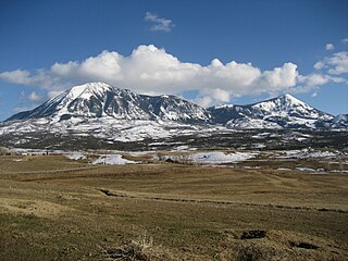
Mount Lamborn is a mountain summit in the West Elk Mountains range of the Rocky Mountains of North America. The 11,402-foot (3,475 m) peak is located in Gunnison National Forest, 5.9 miles (9.5 km) southeast by south of the Town of Paonia in Delta County, Colorado, United States. The summit of Mount Lamborn is the highest point in Delta County. Together with nearby Landsend Peak to the southwest, it lies at the western edge of the West Elks, rising dramatically nearly 6,000 ft above the valley of the North Fork Gunnison River to the west.

<span class="mw-page-title-main">Mount Lola</span>

Mount Lola is a mountain in the Sierra Nevada of California. Its summit, located north of Donner Pass and Interstate 80, is the highest point in Nevada County. It is also the highest point in the Sierra Nevada north of Interstate 80. A subsidiary peak 1.2 miles (1.9 km) north of the main summit is highest point in Sierra County at 8,848 feet (2,697 m) NAVD 88.

<span class="mw-page-title-main">Clark Peak (Medicine Bow Mountains)</span>

Clark Peak is the highest summit of the Medicine Bow Mountains range of the Rocky Mountains of North America. The prominent 12,960-foot (3,950 m) peak is located in the Rawah Wilderness of Routt National Forest, 6.3 miles (10.1 km) north-northwest of Cameron Pass, Colorado, United States, on the drainage divide between Jackson and Larimer counties. Clark Peak is the highest point of Jackson County and the entire drainage basin of the North Platte River.

<span class="mw-page-title-main">Conejos Peak</span> Mountain in Colorado, United States

Conejos Peak is a high and prominent mountain summit in the southern San Juan Mountains of the Rocky Mountains of North America. The 13,179-foot (4,017 m) thirteener is located in the South San Juan Wilderness of Rio Grande National Forest, 19.6 miles (31.6 km) north-northwest of Cumbres Pass in Conejos County, Colorado, United States. The summit of Conejos Peak is the highest point in Conejos County.

<span class="mw-page-title-main">Flat Top Mountain (Colorado)</span> Mountain in Colorado, United States

Flat Top Mountain is the highest summit of the Flat Tops in the Rocky Mountains of North America. The prominent 12,361-foot (3,768 m) peak is located in the Flat Tops Wilderness, 19.1 miles (30.7 km) south-southwest of the Town of Oak Creek, Colorado, United States, on the drainage divide between Routt National Forest and White River National Forest. The summit of Flat Top Mountain is the highest point in Garfield County, Colorado.

For the mountain in California formerly named Summit Peak, see Mount Ina Coolbrith.

Crater Peak is the highest summit of Grand Mesa in the Rocky Mountains of North America. The prominent 11,333-foot (3,454 m) peak is located on the drainage divide separating Grand Mesa National Forest and Gunnison National Forest, 12.3 miles (19.8 km) north-northwest of the Town of Paonia in Delta County, Colorado, United States.

South Bald Mountain is the highest summit of the Laramie Mountains in the Rocky Mountains of North America. The summit in Roosevelt National Forest southwest of Red Feather Lakes is the highest of five peaks forming Bald Mountain.

Zenobia Peak, elevation 9,022 ft (2,750 m), is the highest summit in Dinosaur National Monument of Moffat County, Colorado.

<span class="mw-page-title-main">Mount Guero</span>

Mount Guero is a prominent mountain summit in the West Elk Mountains range of the Rocky Mountains of North America. The 12,058-foot (3,675 m) peak is located in the West Elk Wilderness of the Gunnison National Forest, 13 miles (21 km) east of Crawford, Colorado in Delta County and 24.3 miles (39.1 km) west-southwest of the Town of Crested Butte in Gunnison County, Colorado, United States.

<span class="mw-page-title-main">Green Mountain (Lakewood, Colorado)</span>

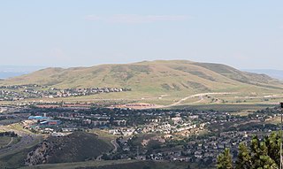
Green Mountain is a mesa on the eastern flank of the Front Range of the Rocky Mountains of North America. The 6,854-foot (2,089 m) mesa summit is located in William Frederick Hayden Park in the City of Lakewood, Colorado, United States, 4.0 miles (6.5 km) west of the municipal center of Lakewood in Jefferson County.

<span class="mw-page-title-main">Mount Morrison (Colorado)</span>

Mount Morrison is a foothill on the eastern flank of the Front Range of the Rocky Mountains of North America. The 7,881-foot (2,402 m) peak is located in Red Rocks Park, 1.9 miles (3.0 km) northwest by west of the Town of Morrison in Jefferson County, Colorado, United States. Red Rocks Amphitheatre is located on the eastern side of the mountain.

Horsefly Peak is the highest summit of the Uncompahgre Plateau in the Rocky Mountains of North America. The 10,353-foot (3,156 m) peak is located 10.0 miles (16.1 km) west by north of the Town of Ridgway in Ouray County, Colorado, United States.

<span class="mw-page-title-main">Mount Owen (Colorado)</span>

Mount Owen is the highest summit of the Ruby Range of the Rocky Mountains of North America. The 13,070-foot (3,984 m) thirteener is located in Gunnison National Forest at the edge of the Raggeds Wilderness, 8.5 miles (13.6 km) west-northwest of the Town of Crested Butte in Gunnison County, Colorado, United States.

Mount Emmons is a mountain summit in the Elk Mountains range of the Rocky Mountains in north-central Gunnison County, Colorado, United States.

<span class="mw-page-title-main">Hahns Peak</span>

Hahns Peak is a summit in Routt County, Colorado, in the United States. With an elevation of 10,774 feet (3,284 m), Hahns Peak is the 1855th highest summit in the state of Colorado.

References

  1. 1 2 "County and equivalent entity". United States Census Bureau, United States Department of Commerce . Retrieved August 17, 2022.
  2. 1 2 3 4 "National Map Search". United States Geological Survey, United States Department of Commerce . Retrieved August 17, 2022.
  3. 1 2 "Peak List". Peakbagger.com. Retrieved August 17, 2022.
  4. 1 2 "Finding Survey Marks and Datasheets". National Geodetic Survey, National Oceanic and Atmospheric Administration, United States Department of Commerce . Retrieved August 17, 2022.
  5. "Elevation Point Query Service". United States Geological Survey, United States Department of Commerce . Retrieved August 17, 2022.
  6. "North American Vertical Datum of 1988 (NAVD 88)". National Geodetic Survey, National Oceanic and Atmospheric Administration, United States Department of Commerce. July 12, 2018. Retrieved August 17, 2022.
  7. "World Geodetic System 1984 (WGS 84)". National Geospatial-Intelligence Agency, United States Department of Defense. March 1, 2022. Retrieved August 17, 2022.
  8. "MOUNT ELBERT". NGS Data Sheet. National Geodetic Survey, National Oceanic and Atmospheric Administration, United States Department of Commerce . Retrieved September 7, 2022.
  9. "Mount Elbert, Colorado". Peakbagger.com. Retrieved September 7, 2022.
  10. "Uncompahgre Peak, Colorado". Peakbagger.com. Retrieved August 16, 2022.
  11. "Phoenix Peak, Colorado". Peakbagger.com. Retrieved August 16, 2022.
  12. "Vermilion Peak, Colorado". Peakbagger.com. Retrieved August 16, 2022.
  13. 1 2 "GRAYS PEAK". NGS Data Sheet. National Geodetic Survey, National Oceanic and Atmospheric Administration, United States Department of Commerce . Retrieved September 7, 2022.
  14. 1 2 "Grays Peak, Colorado". Peakbagger.com. Retrieved September 7, 2022.
  15. 1 2 "Blanca Peak, Colorado". Peakbagger.com. Retrieved August 16, 2022.
  16. "Crestone Peak, Colorado". Peakbagger.com. Retrieved August 17, 2022.
  17. "MT LINCOLN". NGS Data Sheet. National Geodetic Survey, National Oceanic and Atmospheric Administration, United States Department of Commerce . Retrieved September 7, 2022.
  18. "Mount Lincoln, Colorado". Peakbagger.com. Retrieved August 16, 2022.
  19. "HARVARD". NGS Data Sheet. National Geodetic Survey, National Oceanic and Atmospheric Administration, United States Department of Commerce . Retrieved September 7, 2022.
  20. "Mount Harvard, Colorado". Peakbagger.com. Retrieved August 16, 2022.
  21. "Bennett Peak, Colorado". Peakbagger.com. Retrieved August 16, 2022.
  22. "CLARK". NGS Data Sheet. National Geodetic Survey, National Oceanic and Atmospheric Administration, United States Department of Commerce . Retrieved September 7, 2022.
  23. "Clark Peak, Colorado". Peakbagger.com. Retrieved August 16, 2022.
  24. "Denali, Alaska". Peakbagger.com. Retrieved August 16, 2022.
  25. "CONEJOS". NGS Data Sheet. National Geodetic Survey, National Oceanic and Atmospheric Administration, United States Department of Commerce . Retrieved September 7, 2022.
  26. "Conejos Peak, Colorado". Peakbagger.com. Retrieved August 16, 2022.
  27. 1 2 "CASTLE PK". NGS Data Sheet. National Geodetic Survey, National Oceanic and Atmospheric Administration, United States Department of Commerce . Retrieved September 7, 2022.
  28. 1 2 "Castle Peak, Colorado". Peakbagger.com. Retrieved September 7, 2022.
  29. "SNEFFLES". NGS Data Sheet. National Geodetic Survey, National Oceanic and Atmospheric Administration, United States Department of Commerce . Retrieved September 7, 2022.
  30. "Mount Sneffels, Colorado". Peakbagger.com. Retrieved August 16, 2022.
  31. "Pettingell Peak, Colorado". Peakbagger.com. Retrieved August 16, 2022.
  32. 1 2 "GANNETT PEAK CAIRN". NGS Data Sheet. National Geodetic Survey, National Oceanic and Atmospheric Administration, United States Department of Commerce . Retrieved September 7, 2022.
  33. 1 2 "Gannett Peak, Wyoming". Peakbagger.com. Retrieved September 7, 2022.
  34. "James Peak, Colorado". Peakbagger.com. Retrieved August 16, 2022.
  35. "Crestone Peak-East Peak, Colorado". Peakbagger.com. Retrieved August 17, 2022.
  36. "MT HOLY CROSS ET". NGS Data Sheet. National Geodetic Survey, National Oceanic and Atmospheric Administration, United States Department of Commerce . Retrieved September 7, 2022.
  37. "Mount of the Holy Cross, Colorado". Peakbagger.com. Retrieved August 16, 2022.
  38. "Windom Peak, Colorado". Peakbagger.com. Retrieved August 16, 2022.
  39. "Devils Playground, Colorado". Peakbagger.com. Retrieved August 17, 2022.
  40. "GRAND TETON". NGS Data Sheet. National Geodetic Survey, National Oceanic and Atmospheric Administration, United States Department of Commerce . Retrieved September 7, 2022.
  41. "Grand Teton, Wyoming". Peakbagger.com. Retrieved August 16, 2022.
  42. "Blanca Peak-Northeast Slope, Colorado". Peakbagger.com. Retrieved August 16, 2022.
  43. "Mount Wilson, Colorado". Peakbagger.com. Retrieved August 17, 2022.
  44. "SUMMIT". NGS Data Sheet. National Geodetic Survey, National Oceanic and Atmospheric Administration, United States Department of Commerce . Retrieved September 7, 2022.
  45. "Summit Peak, Colorado". Peakbagger.com. Retrieved August 16, 2022.
  46. "Wilson Peak, Colorado". Peakbagger.com. Retrieved August 17, 2022.
  47. "PIKES PEAK". NGS Data Sheet. National Geodetic Survey, National Oceanic and Atmospheric Administration, United States Department of Commerce . Retrieved September 7, 2022.
  48. "Pikes Peak, Colorado". Peakbagger.com. Retrieved August 17, 2022.
  49. "LONGS PEAK". NGS Data Sheet. National Geodetic Survey, National Oceanic and Atmospheric Administration, United States Department of Commerce . Retrieved September 7, 2022.
  50. "Longs Peak, Colorado". Peakbagger.com. Retrieved August 16, 2022.
  51. "WHEELER". NGS Data Sheet. National Geodetic Survey, National Oceanic and Atmospheric Administration, United States Department of Commerce . Retrieved September 7, 2022.
  52. "Wheeler". NGS Data Sheet. National Geodetic Survey, National Oceanic and Atmospheric Administration, United States Department of Commerce . Retrieved August 25, 2022.
  53. "Wheeler Peak, New Mexico". Peakbagger.com. Retrieved August 16, 2022.
  54. "WHITE MOUNTAIN PEAK". NGS Data Sheet. National Geodetic Survey, National Oceanic and Atmospheric Administration, United States Department of Commerce . Retrieved September 7, 2022.
  55. "White Mountain Peak, California". Peakbagger.com. Retrieved August 16, 2022.
  56. "FRANCS PK 2". NGS Data Sheet. National Geodetic Survey, National Oceanic and Atmospheric Administration, United States Department of Commerce . Retrieved September 7, 2022.
  57. "Francs Peak, Wyoming". Peakbagger.com. Retrieved August 16, 2022.
  58. "Gilbert Peak, Utah". Peakbagger.com. Retrieved August 17, 2022.
  59. "TRUCHAS". NGS Data Sheet. National Geodetic Survey, National Oceanic and Atmospheric Administration, United States Department of Commerce . Retrieved September 7, 2022.
  60. "Truchas Peak, New Mexico". Peakbagger.com. Retrieved August 16, 2022.
  61. "Mount Zirkel, Colorado". Peakbagger.com. Retrieved August 16, 2022.
  62. "Kings Peak, Utah". Peakbagger.com. Retrieved August 17, 2022.
  63. "HAGUE RM". NGS Data Sheet. National Geodetic Survey, National Oceanic and Atmospheric Administration, United States Department of Commerce . Retrieved September 7, 2022.
  64. "Hagues Peak, Colorado". Peakbagger.com. Retrieved August 16, 2022.
  65. "BEAUTY RESET". NGS Data Sheet. National Geodetic Survey, National Oceanic and Atmospheric Administration, United States Department of Commerce . Retrieved September 7, 2022.
  66. "WHEELER PEAK". NGS Data Sheet. National Geodetic Survey, National Oceanic and Atmospheric Administration, United States Department of Commerce . Retrieved September 7, 2022.
  67. "Borah Peak, Idaho". Peakbagger.com. Retrieved August 16, 2022.
  68. "WHEELER PEAK". NGS Data Sheet. National Geodetic Survey, National Oceanic and Atmospheric Administration, United States Department of Commerce . Retrieved September 7, 2022.
  69. "Wheeler Peak, Nevada". Peakbagger.com. Retrieved August 16, 2022.
  70. "SANTA FE BALDY". NGS Data Sheet. National Geodetic Survey, National Oceanic and Atmospheric Administration, United States Department of Commerce . Retrieved September 7, 2022.
  71. "Santa Fe Baldy, New Mexico". Peakbagger.com. Retrieved August 16, 2022.
  72. "TWIN". NGS Data Sheet. National Geodetic Survey, National Oceanic and Atmospheric Administration, United States Department of Commerce . Retrieved September 7, 2022.
  73. "Bushnell Peak, Colorado". Peakbagger.com. Retrieved August 16, 2022.
  74. "Little Costilla Peak, New Mexico". Peakbagger.com. Retrieved August 16, 2022.
  75. "Mount Saint Elias, Alaska/Yukon". Peakbagger.com. Retrieved August 16, 2022.
  76. "DELANO PEAK M 5". NGS Data Sheet. National Geodetic Survey, National Oceanic and Atmospheric Administration, United States Department of Commerce . Retrieved September 7, 2022.
  77. "Delano Peak, Utah". Peakbagger.com. Retrieved August 16, 2022.
  78. "West Spanish Peak, Colorado". Peakbagger.com. Retrieved August 16, 2022.
  79. "Hesperus Mountain, Colorado". Peakbagger.com. Retrieved August 16, 2022.

Coordinates: 44°58′02″N103°46′18″W / 44.9672°N 103.7716°W / 44.9672; -103.7716 (United States of America)