
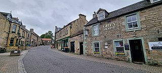
Dufftown is a burgh in Moray, Scotland. While the town is part of the historic Mortlach parish, the town was established and laid out in the early 19th century as part of a planned new town settlement. The town has several listed 19th century buildings and serves as a regional centre for agriculture, tourism and services. The town is well known for its whisky based economy, as it produces more whisky than any other town in Scotland and is home to several existing and former distilleries.

Broxburn is a town in West Lothian, Scotland. It is 12 miles (19 km) from the West End of Edinburgh, 5 miles (8.0 km) from Edinburgh Airport and 5 miles (8.0 km) to the north of Livingston. Originally a village known as Easter Strathbock in the medieval period, by 1600, the village had become known as Broxburn. The area developed rapidly during the Victorian era as a result of industralisation related to shale oil extraction. While much of the industry in the area is now diminished, the town has continued to grow following new residential development, resulting in Broxburn forming a conurbation with neighbouring Uphall.

Holyrood Park is a royal park in central Edinburgh, Scotland about 1 mile to the east of Edinburgh Castle. It is open to the public. It has an array of hills, lochs, glens, ridges, basalt cliffs, and patches of gorse, providing a wild piece of highland landscape within its 650-acre (260 ha) area. The park is associated with the royal palace of Holyroodhouse and was formerly a 12th-century royal hunting estate. The park was created in 1541 when James V had the ground "circulit about Arthurs Sett, Salisborie and Duddingston craggis" enclosed by a stone wall.

Bathgate is a town in West Lothian, Scotland, 5 miles (8 km) west of Livingston and adjacent to the M8 motorway. Nearby towns are Armadale, Blackburn, Linlithgow, Livingston, West Calder and Whitburn. Situated 2 miles (3 km) south of the ancient Neolithic burial site at Cairnpapple Hill, Bathgate and the surrounding area show signs of habitation since about 3500 BC and the world's oldest known reptile fossil has been found in the town. By the 12th century, Bathgate was a small settlement, with a church at Kirkton and a castle south of the present day town centre. Local mines were established in the 17th century but the town remained small in size until the coming of the industrial revolution. By the Victorian era, Bathgate grew in prominence as an industrial and mining centre, principally associated with the coal and shale oil industries. By the early 20th century, much of the mining and heavy industry around the town had ceased and the town developed manufacturing industries, principally in vehicle production and later electronics before these factories closed in the late 20th century. Today Bathgate is the second largest town in West Lothian, after Livingston and serves as a regional commuter town within the Scottish Central Belt.

Corrour railway station is on the West Highland Line, near Loch Ossian on the Corrour Estate, in the Highland Region of Scotland. It is the highest mainline railway station in the United Kingdom. It is located between Rannoch and Tulloch, and is sited 71 miles 54 chains (115.3 km) from Craigendoran Junction, near Helensburgh. ScotRail manage the station and provide most services, along with Caledonian Sleeper.

The Queen's Gallery is an art gallery in Edinburgh, Scotland. It forms part of the Palace of Holyroodhouse complex. It was opened in 2002 by Queen Elizabeth II, and exhibits works from the Royal Collection.
Balerno is a village on the outskirts of Edinburgh, Scotland situated 8 miles south-west of the city centre, next to Currie and then Juniper Green. Traditionally in the county of Midlothian it now administratively falls within the jurisdiction of the City of Edinburgh Council. The village lies at the confluence of the Water of Leith and the Bavelaw Burn. In the 18th and 19th century, the area was home to several mills using waterpower. In the 20th century, the mills closed and the village now forms a residential suburb of Edinburgh.

Carnwath is a moorland village on the southern edge of the Pentland Hills of South Lanarkshire, Scotland. The village lies about 30 mi (50 km) south of both Edinburgh and Glasgow. It is bounded by the North Medwyn and South Medwyn watercourses.

Abbeyhill is an area of Edinburgh, the capital of Scotland.
Longstone is a suburb of Edinburgh in Scotland. The area is primarily residential in nature, although the area includes several small shops, eateries and supermarkets, as well as one of the main bus depots for the city's buses. The population of Longstone was 4,678 in 2019.

Armadale is a town within the county of West Lothian in the Central Belt of Scotland. It lies to the west of Bathgate and to the east of Blackridge. Armadale, formerly known as Barbauchlaw, is an ex-mining town which was also known for its brick manufacturing. It is named after Armadale in Sutherland, this estate being owned by Sir William Honeyman who later acquired the land of Barbauchlaw. Primarily a residential community, the town has a number of different public places, a central Mains Street and a series of parks, green spaces and nature reserves, many of which lie atop former mines and industrial areas.

Linlithgow is a town in West Lothian, Scotland. It was historically West Lothian's county town, reflected in the county's historical name of Linlithgowshire. An ancient town, it lies in the Central Belt on an historic route between Edinburgh and Falkirk beside Linlithgow Loch. The town is situated approximately 20 miles west of Edinburgh.

Kingsknowe is a suburb of Edinburgh the capital of Scotland. It is south-west of Craiglockhart, and borders Wester Hailes, Slateford and Longstone.
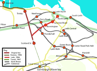
The Edinburgh, Leith and Newhaven Railway was a railway company formed in 1836 to connect the city of Edinburgh with the harbours on the Firth of Forth. When the line connected to Granton, the company name was changed to the Edinburgh, Leith and Granton Railway. It opened part of its route in 1846, but reaching the centre of Edinburgh involved the difficult construction of a long tunnel; this was opened in 1847. It was on a steep incline and was worked by rope haulage.

Meadowbank Parish Church is a congregation of the Church of Scotland in Edinburgh, Scotland. It is based in a late-Victorian church building on London Road, Abbeyhill, around 0.5 miles (0.80 km) north of Holyrood Abbey. The church building was opened in December 1900 as Abbeyhill United Free Church.

The following outline is provided as an overview of and topical guide to Edinburgh:

St Margaret's Well (NT271737) is a Category B listed holy well that was relocated to Holyrood Park off Queen's Drive in Edinburgh from Restalrig in 1860. It is one of seven wells located in the park.
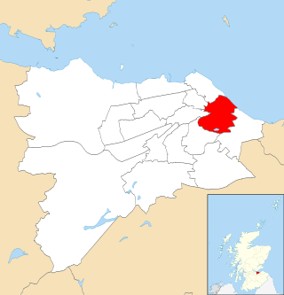
Craigentinny/Duddingston is one of the seventeen wards used to elect members of the City of Edinburgh Council. Established in 2007 along with the other wards, it currently elects four Councillors.


