
Edinburgh is the capital city of Scotland and one of its 32 council areas. The city is located in south-east Scotland, and is bounded to the north by the Firth of Forth estuary and to the south by the Pentland Hills. Edinburgh had a population of 506,520 in mid-2020, making it the second-most populous city in Scotland and the seventh-most populous in the United Kingdom. The wider metropolitan area has a population of 912,490.

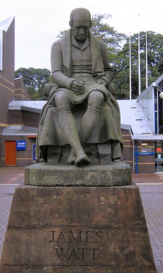
Heriot-Watt University is a public research university based in Edinburgh, Scotland. It was established in 1821 as the School of Arts of Edinburgh, the world's first mechanics' institute, and subsequently granted university status by royal charter in 1966. It is the eighth-oldest higher education institution in the United Kingdom. The name Heriot-Watt was taken from Scottish inventor James Watt and Scottish philanthropist and goldsmith George Heriot.

Edinburgh Napier University is a public university in Edinburgh, Scotland. Napier Technical College, the predecessor of the university, was founded in 1964, taking its name from 16th-century Scottish mathematician and philosopher John Napier. The technical college was inaugurated as a university in 1992 by Lord Douglas-Hamilton, becoming Napier University. In 2009, the university was renamed Edinburgh Napier University.
Heriot-Watt University Football Club is a football club based at Riccarton Campus, on the western fringes of Edinburgh. The club's first team plays in the East of Scotland League First Division. Home matches are played on a 3G synthetic pitch within the John Brydson Arena on the university campus at Riccarton. In weekend competition, the club also enters a team into the Lowlands Under-20 Development League; and another into Lothian & Edinburgh Amateur Football Association competition.

Colinton is a suburb of Edinburgh, Scotland situated 3+1⁄2 miles southwest of the city centre. Up until the late 18th century it appears on maps as Collington. It is bordered by Dreghorn to the south and Craiglockhart to the north-east. To the north-west it extends to Lanark Road and to the south-west to the City Bypass. Bonaly is a subsection of the area on its southern side.
Sighthill is a suburb in the west of Edinburgh, Scotland. The area is bordered by Broomhouse and Parkhead to the east, South Gyle to the north, the industrial suburb of Bankhead and the Calders neighbourhood to the west, and Wester Hailes to the south. It is sometimes included in the Wester Hailes area, while the Calders, Bankhead and Parkhead are sometimes considered parts of Sighthill. Administratively it has formed a core part of the City of Edinburgh Council's Sighthill/Gorgie ward since 2007.

Bankhead is a non-residential area of western Edinburgh, Scotland. It borders the Edinburgh City Bypass (A720) and Hermiston Gait to the west, the Calders neighbourhood to the south – accessed via a pedestrian underpass, Sighthill to the east, and South Gyle/Edinburgh Park to the north. It is mostly occupied by a large industrial park. Amongst the companies here, Royal Mail and Burtons Biscuits have a large presence. Ethicon also had a plant here, but it has closed, and will reportedly be replaced by a sports facilities. Edinburgh College, the former Stevenson College and the Sighthill campus of Napier University are just to the west.
Currie is a village and suburb on the outskirts of Edinburgh, Scotland, situated 7 miles south west of the city centre. Formerly within the County of Midlothian, it now falls within the jurisdiction of the City of Edinburgh Council. It is situated between Juniper Green to the northeast and Balerno to the southwest. It gives its name to a civil parish.

The Calders is a residential neighbourhood in Edinburgh, Scotland – not to be confused with the Calders of West Lothian aka West Calder, Mid Calder and East Calder, three separate villages. It is sometimes considered to be part of Wester Hailes or Sighthill, larger developments to its south and east respectively. From 2007 to 2017, it fell within the Sighthill/Gorgie multi-member ward of the City of Edinburgh Council administration along with Sighthill, but following a boundary change has been in the Pentland Hills ward since then, along with Wester Hailes.
Riccarton is an area in Edinburgh's Green Belt, in Scotland. It is mainly undeveloped, with much farmland and few houses.
Niddrie is a residential suburb in Edinburgh, Scotland. It is situated in the south-east of the city, south-west of the seaside area of Portobello, and west of Musselburgh in East Lothian near Fort Kinnaird retail park. The western section of Niddrie is also known by the alternative name of Craigmillar.
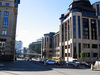
Edinburgh, the capital city of Scotland, is a powerhouse of the Scottish economy, as well as the wider UK economy. Edinburgh has been consistently one of the most prosperous parts of the country and has the strongest economy of any city in the UK outside London. Financial Times FDi Magazine has named Edinburgh as the "Best Large European City of the Future" and "Best Foreign Direct Investment Strategy " for 2012/13.

Hermiston is a hamlet formerly in the county of Midlothian and now part of Edinburgh, the capital of Scotland. It is north of Heriot-Watt University's Riccarton Campus and west of the Hermiston Gait commercial development. Hermiston is bounded by the A71 Calder Road to the south and the Union Canal to the north with the M8 motorway just beyond. The hamlet forms the Hermiston Conservation Area.

Newbridge is a village in the civil parish of Kirkliston, west of Edinburgh in Scotland. It formerly lay on the western fringe of Midlothian, but it has belonged to the City of Edinburgh since 1975. The original village consists of a small crossroads settlement to the east of the eponymous New Bridge, which spans the River Almond. Around it is a confusion of roads and industrial estates converging on the Newbridge Roundabout, the meeting point of the M8 and M9 motorways.
Slateford is an area of Edinburgh, the capital of Scotland. It is east of the Water of Leith.

Edinburgh College is a further and higher education institution with campuses in Edinburgh and Midlothian, Scotland. It serves the Edinburgh Region, Edinburgh, East Lothian and Midlothian, and is the largest college in Scotland. It was formed on 1 October 2012 as part of the merger of Edinburgh's Jewel and Esk, Telford, and Stevenson colleges. The college has four campuses, all of which were previously the campuses of the constituents of the merger: Jewel and Esk's College Milton Road (Jewel) Campus and Eskbank Campus ; Edinburgh Telford College ; and Stevenson College Edinburgh

The Edinburgh Science Triangle (EST) is a multi-disciplinary partnership between universities, research institutes, the National Health Service, science parks, the national economic development agency Scottish Enterprise, and central and local government in Edinburgh and neighbouring council areas. The three points of the "triangle" are Livingston in West Lothian, Musselburgh in East Lothian, and the Easter Bush campus in Midlothian.

The following outline is provided as an overview of and topical guide to Edinburgh:
Mary Hill Burton (1819–1909) was a Scottish social and educational reformer and the first woman governor of Heriot-Watt College.


