
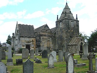
Uphall is a village in West Lothian, Scotland. It is a swiftly growing village in a conurbation with Broxburn to the east, Dechmont to the west and the major town of Livingston to the south west. Uphall is 30 miles from Glasgow and 14 miles from Edinburgh in the Scottish Lowlands. Uphall Station and Pumpherston are separate villages that lie to the south of Uphall.

Murrayfield is an area to the west of Edinburgh city centre in Scotland. It is to the east of Corstorphine and north of Balgreen, Saughtonhall and Roseburn. The A8 road runs east–west through the south of the area. Murrayfield is often considered to include the smaller neighbouring areas of Ravelston and Roseburn.
Corstorphine is an area of the Scottish capital city of Edinburgh. Formerly a separate village and parish to the west of Edinburgh, it is now a suburb of the city, having been formally incorporated into it in 1920.

Balgreen is a suburb of Edinburgh, located approximately two miles west of the city centre, most commonly known for its primary school, Balgreen Primary. It is located to the west of Murrayfield and Saughtonhall, to the east of Corstorphine, and to the north of Gorgie. It is bound to the north by Corstorphine Hill, to the west by Carrick Knowe Golf Course, and roughly to the east by Water of Leith.

Saughton is a suburb of the west of Edinburgh, Scotland, bordering Broomhouse, Stenhouse, Longstone and Carrick Knowe. In Lowland Scots, a "sauch" is a willow. The Water of Leith flows by here.
Longstone is a suburb of Edinburgh in Scotland. The area is primarily residential in nature, although the area includes several small shops, eateries and supermarkets, as well as one of the main bus depots for the city's buses. The population of Longstone was 4,678 in 2019.

East Craigs is a residential district of Edinburgh located in the north-west of the city, on the western flanks of Corstorphine Hill. It lies next to the green belt, and prior to development was a working farm.

Gogar is a predominantly rural area of Edinburgh, Scotland, located to the west of the city. It is not far from Gogarloch, Edinburgh Park and Maybury. The Fife Circle Line is to the north.

Corstorphine Hill is a low ridge-shaped hill rising above the western suburbs of Edinburgh, Scotland. Although there has been residential and commercial development on its lower slopes, especially in the south and west, most of the hill is occupied by a local nature reserve, consisting of extensive broadleaf woodland, accessible to the public.

Broomhouse is a district of Edinburgh, Scotland. Although on the lands of Old Saughton, its name is adopted from an estate which lay to the north of the Edinburgh and Glasgow Railway. The earliest recorded versions of the name (c.1600) were variations on Brum(e)hous. It mainly comprises a low-rise council housing estate built between 1947 and 1950. It borders on Parkhead, Sighthill, and Saughton Mains. The arterial route of Calder Road (A71) passes to the south.
Tollcross is a major road junction to the south west of the city centre of Edinburgh, Scotland which takes its name from a local historical land area.

Maybury is an area on the western edge of Edinburgh, Scotland, near South Gyle and Ingliston, named after the road, which is itself named after the civil engineer Sir Henry Maybury (1864–1943). In 2021, residents have been undertaking community clean ups to clear the foot paths along the road. The area is residential in the north east/east and commercial in the south and west and The Gyle Shopping Centre is nearby. In 2021, there was a consultation about creating a Primary School and Health Centre in Maybury.
Cammo is a northwestern suburb of Edinburgh, the capital of Scotland. It is south of A90, at the edge of the city, approximately 6 miles from the city centre.

Pilrig is an area of Edinburgh, the capital of Scotland. The name probably derives from the long field (rig) on which a peel tower (pil/peel) stood. There is evidence of a peel tower situated on an area of higher ground above the Water of Leith.
Ravelston is an area of Edinburgh, Scotland, to the west of the city centre, the east of Corstorphine and Clermiston, the north of Murrayfield, West End and Roseburn and to the south of Queensferry Road. Ravelston is often considered to be part of the larger neighbouring area of Murrayfield.
Torphin is a small area in the south-west of Edinburgh, Scotland, with its name deriving from the nearby Torphin Hill. It lies just south of Juniper Green, on the opposite side of the Water of Leith, and sits both east and west of the Edinburgh City Bypass: the east side mostly comprises new-build houses; the west side is largely rural, sporting a small number of mid-20th Century bungalows and one of the city's many golf courses, Torphin Hill Golf Club.
Ebenezer James MacRae was a Scottish architect serving as City Architect for Edinburgh for most of his active life.

Corstorphine/Murrayfield is one of the seventeen wards used to elect members of the City of Edinburgh Council. Established in 2007 along with the other wards, it currently elects three Councillors.
Stewart Kaye FRIBA FRICS (1885–1952) was a Scottish architect in the 20th century. Working in a stripped down Scottish version of the Art Deco style he was consultant architect to the Presbytery of East Lothian and the Halifax Building Society. Mainly based in Edinburgh he is responsible for a large proportion of the city's housing estates from the 1930s.

Saughtonhall is a residential neighbourhood in the west of Edinburgh, Scotland, bordering Balgreen directly to the south and south-west, Murrayfield to the north, Carrick Knowe golf course to the west, and sports facilities on the opposite bank of the Water of Leith and its walkway to the east, connected by several footbridges which now also incorporate flooding defences. It is within the Corstorphine/Murrayfield ward under the City of Edinburgh Council.

