
Midlothian is a historic county, registration county, lieutenancy area and one of 32 council areas of Scotland used for local government. Midlothian lies in the east-central Lowlands, bordering the City of Edinburgh council area, East Lothian and the Scottish Borders.

The Edinburgh City Bypass, designated as A720, is one of the most important trunk roads in Scotland. Circling around the south of Edinburgh, as the equivalent of a ring road for the coastal city, it links together the A1 towards north-east England, the A702 towards north-west England, the M8 through the Central Belt towards Glasgow, the A7 through south-east Scotland and north-west England as well as the A8 leading to the M9 for Stirling and the Queensferry Crossing.
Edinburgh South was a constituency of the Scottish Parliament (Holyrood). It elected one Member of the Scottish Parliament (MSP) by the plurality method of election. Also, however, it was one of nine constituencies in the Lothians electoral region, which elected seven additional members, in addition to nine constituency MSPs, to produce a form of proportional representation for the region as a whole.

Wester Hailes is an area in the south west of Edinburgh, Scotland.
Ratho is a village in the rural west part of the City of Edinburgh council area, Scotland. Its population at the 2011 census was 1,634 based on the 2010 definition of the locality. It was formerly in the old county of Midlothian. Ratho Station, Newbridge and Kirkliston are other villages in the area. The Union Canal passes through Ratho. Edinburgh Airport is situated only 4 miles (7 km) away. The village has a high ratio of its older houses built from whin stone due to a whin quarry nearby. The older, historical, part of the village was designated a Conservation Area in 1971 by Midlothian County Council.

Bankhead is a non-residential area of western Edinburgh, Scotland. It borders the Edinburgh City Bypass (A720) and Hermiston Gait to the west, the Calders neighbourhood to the south – accessed via a pedestrian underpass, Sighthill to the east, and South Gyle/Edinburgh Park to the north. It is mostly occupied by a large industrial park. Amongst the companies here, Royal Mail and Burtons Biscuits have a large presence. Ethicon also had a plant here, but it has closed, and will reportedly be replaced by a sports facilities. Edinburgh College, the former Stevenson College and the Sighthill campus of Napier University are just to the west.

The Calders is a residential neighbourhood in Edinburgh, Scotland – not to be confused with the Calders of West Lothian aka West Calder, Mid Calder and East Calder, three separate villages. It is sometimes considered to be part of Wester Hailes or Sighthill, larger developments to its south and east respectively. From 2007 to 2017, it fell within the Sighthill/Gorgie multi-member ward of the City of Edinburgh Council administration along with Sighthill, but following a boundary change has been in the Pentland Hills ward since then, along with Wester Hailes.
Niddrie is a residential suburb in Edinburgh, Scotland. It is situated in the south-east of the city, south-west of the seaside area of Portobello, and west of Musselburgh in East Lothian near Fort Kinnaird retail park. The western section of Niddrie is also known by the alternative name of Craigmillar.
Chesser is a mainly residential suburb of Edinburgh, Scotland, east of the Water of Leith. It, with Longstone, is to the south-west, Allan Park and Craiglockhart to the south, Slateford, Hutchison and Moat to the east, and Gorgie Road to the north.

Newbridge is a village in the civil parish of Kirkliston, west of Edinburgh in Scotland. It formerly lay on the western fringe of Midlothian, but it has belonged to the City of Edinburgh since 1975. The original village consists of a small crossroads settlement to the east of the eponymous New Bridge, which spans the River Almond. Around it is a confusion of roads and industrial estates converging on the Newbridge Roundabout, the meeting point of the M8 and M9 motorways.
Parkhead is a residential area of Edinburgh, the capital of Scotland. It was one of the smallest wards in the Edinburgh City Council before a reorganisation into larger multi-member wards in 2007; since then it has been part of the Sighthill/Gorgie ward.
Slateford is an area of Edinburgh, the capital of Scotland. It is east of the Water of Leith.
The Edinburgh Suburban and Southside Junction Railway was a railway company that built an east-west railway on the southern margin of Edinburgh, Scotland, primarily to facilitate the operation of heavy goods and mineral traffic across the city. The line opened in 1884. Although its route was rural at the time, suburban development quickly caught up and passenger carryings on the line were buoyant; the passenger service operated on a circular basis through Edinburgh Waverley railway station.

East Calder is a village located in West Lothian, Scotland, about a mile east of Mid Calder and a mile west of Wilkieston. It forms part of 'the Calders, three small neighbouring communities situated west of Edinburgh and south of the "New Town" of Livingston.
Ebenezer James MacRae was a Scottish architect serving as City Architect for Edinburgh for most of his active life.

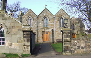
St Joseph's Church, Sighthill,, is a Roman Catholic church situated in Broomhouse, in the west of Edinburgh, Scotland. The parish boundary extends to Broomhouse, Parkhead, Saughton, Sighthill, Gorgie and further.

Pentland Hills is one of the seventeen wards used to elect members of the City of Edinburgh Council. Established in 2007 along with the other wards, it mainly covers the villages and suburban developments in the south-west hinterland beyond the A720 Edinburgh city bypass road, up to the boundaries with West Lothian, Midlothian and a small border with the Scottish Borders at the edge of the Pentland Hills.

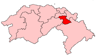
Sighthill/Gorgie is one of the seventeen wards used to elect members of the City of Edinburgh Council, established in 2007 along with the other wards. Its territory comprises a corridor of land in the west of the city with a northern boundary formed by the railway lines between the Haymarket and Edinburgh Park stations, encompassing the Broomhouse, Dalry, Gorgie, Longstone, Parkhead, Saughton, Sighthill and Stenhouse neighbourhoods. It elects four Councillors. In 2019, the ward had a population of 33,826.


