National Register of Historic Places listings in Central Chicago

Last updated

Currently there are 124 properties listed on the National Register of Historic Places in Central Chicago, out of more than 350 listings in the City of Chicago. Central Chicago includes 3 of the 77 well-defined community areas of Chicago: the historic business and cultural center of Chicago known as the Loop, as well as the Near North Side and the Near South Side. The combined area is bounded by Lake Michigan on the east, the Chicago River on the west, North Avenue (1600 N.) on the north, and 26th Street (2600 S.) on the south. This area runs 5.25 miles (8.45 km) from north to south and about 1.5 miles (2.4 km) from east to west.

Contents

Map all coordinates using: OpenStreetMap

The Chicago central city area includes many early classic skyscrapers of the Chicago School of Architecture, such as Burnham and Root's Monadnock and the Reliance Buildings, as well as buildings from the early Modernist period, such as Ludwig Mies van der Rohe's IBM Building and 860–880 Lake Shore Drive Apartments. Chicago's earliest surviving building, the Henry B. Clarke House (built c. 1836) is on the Near South Side, close to the Prairie Avenue District of residential Chicago architecture. Architect Louis Sullivan's work is represented by the Carson, Pirie, Scott and Company Building, and Auditorium Building. Though Frank Lloyd Wright worked downtown first as an assistant to Sullivan (including work on the Auditorium and James Charnley House) and then in his own firm - his major remaining work in the central city is represented only by his well regarded renovation of the lobby of the Root and Burnham's Rookery Building.

At least three sites relate to the city's role in nationwide retailing. [1] Included also are several religious buildings, six hotels, [2] and four theaters. [3]


    This National Park Service list is complete through NPS recent listings posted January 12, 2024. [4]

NRHP-listed
NRHP-listed Historic district
* National Historic Landmark and NRHP-listed
National Historic Landmark and NRHP-listed Historic district

Current listings

[5] Name on the Register [6] ImageDate listed [7] Location NeighborhoodDescription
1 Adler Planetarium
Adler Planetarium Adler fg02.jpg
Adler Planetarium
February 27, 1987
(#87000819)
1300 S. Lake Shore Drive
41°51′58″N87°36′24″W / 41.866111°N 87.606667°W / 41.866111; -87.606667 (Adler Planetarium)
Near South Side Built in 1930
2 America Fore Building
America Fore Building America Force Building.jpg
America Fore Building
June 21, 2016
(#16000383)
844 N. Rush Street
41°53′53″N87°37′34″W / 41.898056°N 87.626245°W / 41.898056; -87.626245 (America Fore Building)
Near North Side
3 Auditorium Building, Roosevelt University
Auditorium Building, Roosevelt University Auditorium Building Chicago.jpg
Auditorium Building, Roosevelt University
April 17, 1970
(#70000230)
430 S. Michigan Avenue
41°52′32″N87°37′29″W / 41.875556°N 87.624722°W / 41.875556; -87.624722 (Auditorium Building, Roosevelt University)
Chicago Loop Built in 1889
4 B.F. Goodrich Company Showroom
B.F. Goodrich Company Showroom BF Goodrich Company Showroom Chicago IL.jpg
B.F. Goodrich Company Showroom
May 28, 2009
(#09000347)
1925 S. Michigan Avenue
41°51′21″N87°37′24″W / 41.855958°N 87.623425°W / 41.855958; -87.623425 (B.F. Goodrich Company Showroom)
Near South Side
5 Balaban and Katz Chicago Theatre
Balaban and Katz Chicago Theatre Chicago Theatre blend.jpg
Balaban and Katz Chicago Theatre
June 6, 1979
(#79000822)
175 N. State Street
41°53′08″N87°37′38″W / 41.885556°N 87.627222°W / 41.885556; -87.627222 (Balaban and Katz Chicago Theatre)
Chicago Loop Built in 1921
6 Blackstone Hotel
Blackstone Hotel 2004-09-17 1600x2840 chicago blackstone.jpg
Blackstone Hotel
May 8, 1986
(#86001005)
80 E. Balbo Drive
41°52′24″N87°37′28″W / 41.873333°N 87.624444°W / 41.873333; -87.624444 (Blackstone Hotel)
Chicago Loop Built in 1910
7 Boyce Building
Boyce Building 20090909 Boyce Building.JPG
Boyce Building
February 29, 1996
(#96000080)
500–510 N. Dearborn Street
41°53′28″N87°37′48″W / 41.891111°N 87.63°W / 41.891111; -87.63 (Boyce Building)
Near North Side
8 Buckingham Building
Buckingham Building 20080703 Buckingham Building.JPG
Buckingham Building
August 10, 2000
(#00000942)
63 E. Van Buren Street
41°52′36″N87°37′30″W / 41.876667°N 87.625°W / 41.876667; -87.625 (Buckingham Building)
Chicago Loop
9 Building at 14–16 Pearson Street
Building at 14-16 Pearson Street Hartwell Chicago.jpg
Building at 14–16 Pearson Street
May 8, 1980
(#80001343)
14–16 E. Pearson Street
41°53′51″N87°37′40″W / 41.8975°N 87.627778°W / 41.8975; -87.627778 (Building at 14–16 Pearson Street)
Near North Side
10 Building at 257 East Delaware Place
Building at 257 East Delaware Place 257 East Delaware Chicago.JPG
Building at 257 East Delaware Place
June 26, 1987
(#87001113)
257 E. Delaware Place
41°53′57″N87°37′10″W / 41.899167°N 87.619444°W / 41.899167; -87.619444 (Building at 257 East Delaware Place)
Near North Side
11 Buildings at 860–880 N. Lake Shore Drive
Buildings at 860-880 N. Lake Shore Drive 860-880 Lake Shore Drive.jpg
Buildings at 860–880 N. Lake Shore Drive
August 28, 1980
(#80001344)
860–880 N. Lake Shore Drive
41°53′55″N87°37′08″W / 41.898658°N 87.618839°W / 41.898658; -87.618839 (Buildings at 860–880 N. Lake Shore Drive)
Near North Side Built in 1949
12 Burlingham Building
Burlingham Building 104 W Oak Chicago.JPG
Burlingham Building
February 14, 1985
(#85000264)
104 W. Oak Street
41°54′04″N87°37′54″W / 41.901111°N 87.631667°W / 41.901111; -87.631667 (Burlingham Building)
Near North Side
13 Bush Temple of Music
Bush Temple of Music Bush Temple of Music 1.JPG
Bush Temple of Music
December 31, 2013
(#13001001)
100 W. Chicago Avenue, 800 N. Clark Street
41°53′49″N87°37′54″W / 41.896819°N 87.631696°W / 41.896819; -87.631696 (Bush Temple of Music)
Near North Side
14 Calumet Plant, R. R. Donnelly & Sons Company
Calumet Plant, R. R. Donnelly & Sons Company Calumet Plant R R Donnelly and Sons Company B Chicago IL.jpg
Calumet Plant, R. R. Donnelly & Sons Company
February 17, 1983
(#83000308)
350 E. Cermak Road
41°51′13″N87°37′05″W / 41.853611°N 87.618056°W / 41.853611; -87.618056 (Calumet Plant, R. R. Donnelly & Sons Company)
Near South Side
15 Carling Hotel
Carling Hotel The Carling Hotel.jpg
Carling Hotel
January 24, 2017
(#100000563)
1512 N. LaSalle Street
41°54′35″N87°38′01″W / 41.909662°N 87.633549°W / 41.909662; -87.633549 (Carling Hotel)
Near North Side
16 Carson, Pirie, Scott and Company Building
Carson, Pirie, Scott and Company Building Carson Pirie Scott building, Chicago, Illinois - Louis Sullivan.jpg
Carson, Pirie, Scott and Company Building
April 17, 1970
(#70000231)
1 S. State Street
41°52′54″N87°37′39″W / 41.881667°N 87.6275°W / 41.881667; -87.6275 (Carson, Pirie, Scott and Company Building)
Chicago Loop Now occupied by a Target department store
17 Chapin and Gore Building
Chapin and Gore Building Chapin & Gore Building, 63 East Adams Street, Chicago (Cook County, Illinois).jpg
Chapin and Gore Building
June 27, 1979
(#79000823)
63 E. Adams Street
41°52′45″N87°37′31″W / 41.879167°N 87.625278°W / 41.879167; -87.625278 (Chapin and Gore Building)
Chicago Loop
18 James Charnley House
James Charnley House James Charnley Residence HABS ILL,16-CHIG,12-1.jpg
James Charnley House
April 17, 1970
(#70000232)
1365 N. Astor Street
41°54′28″N87°37′40″W / 41.907778°N 87.627778°W / 41.907778; -87.627778 (James Charnley House)
Near North Side
19 Chicago Avenue Water Tower and Pumping Station
Chicago Avenue Water Tower and Pumping Station Chicago Water Tower (October 2008).jpg
Chicago Avenue Water Tower and Pumping Station
April 23, 1975
(#75000644)
806 N. Michigan Avenue
41°53′50″N87°37′26″W / 41.897222°N 87.623889°W / 41.897222; -87.623889 (Chicago Avenue Water Tower and Pumping Station)
Near North Side Survived the Great Fire of October 1871
20 Chicago Board of Trade Building
Chicago Board of Trade Building Cbot-close-night.jpg
Chicago Board of Trade Building
June 16, 1978
(#78003181)
141 W. Jackson Boulevard
41°52′41″N87°37′56″W / 41.878139°N 87.632278°W / 41.878139; -87.632278 (Chicago Board of Trade Building)
Chicago Loop
21 Chicago Club
Chicago Club Chicago Club 81 East Van Buren Street.jpg
Chicago Club
February 28, 2005
(#05000109)
81 E. Van Buren Street
41°52′37″N87°37′29″W / 41.876944°N 87.624722°W / 41.876944; -87.624722 (Chicago Club)
Chicago Loop 1929
Granger and Bollenbacher
Romanesque Revival
22 Chicago Federal Center
Chicago Federal Center Chicago Federal Center.jpg
Chicago Federal Center
March 24, 2011
(#08001165)
Entire block bounded by S. Dearborn Street, W. Jackson Street, S. Clark Street and W. Adams Street and the contiguous half-block east of S. Dearborn Street
41°52′44″N87°37′48″W / 41.878889°N 87.63°W / 41.878889; -87.63 (Chicago Federal Center)
Chicago Loop
23 Chicago Harbor Lighthouse
Chicago Harbor Lighthouse Chicago-lighthouse.jpg
Chicago Harbor Lighthouse
July 19, 1984
(#84000986)
North Breakwater
41°53′22″N87°35′26″W / 41.889444°N 87.590556°W / 41.889444; -87.590556 (Chicago Harbor Lighthouse)
Near North Side
24 Chicago Public Library, Central Building
Chicago Public Library, Central Building Chicago Cultural Center.jpg
Chicago Public Library, Central Building
July 31, 1972
(#72000449)
78 E. Washington Street
41°53′02″N87°37′30″W / 41.883889°N 87.625°W / 41.883889; -87.625 (Chicago Public Library, Central Building)
Chicago Loop
25 Chicago Savings Bank Building
Chicago Savings Bank Building 20080703 Chicago Savings Bank Building.JPG
Chicago Savings Bank Building
September 5, 1975
(#75000645)
7 W. Madison Street
41°52′54″N87°37′42″W / 41.881667°N 87.628333°W / 41.881667; -87.628333 (Chicago Savings Bank Building)
Chicago Loop
26 Chicago Varnish Company Building
Chicago Varnish Company Building Chicago Varnish Company Building.JPG
Chicago Varnish Company Building
June 14, 2001
(#01000649)
33 W. Kinzie Street
41°53′20″N87°37′46″W / 41.888889°N 87.629444°W / 41.888889; -87.629444 (Chicago Varnish Company Building)
Near North Side
27 Henry B. Clarke House
Henry B. Clarke House Clarke House.jpg
Henry B. Clarke House
May 6, 1971
(#71000290)
1827 Indiana Avenue
41°51′26″N87°37′19″W / 41.857222°N 87.621944°W / 41.857222; -87.621944 (Henry B. Clarke House)
Near South Side
28 Coca Cola Company Building
Coca Cola Company Building Coca Cola Company Building Chicago IL.jpg
Coca Cola Company Building
February 22, 1991
(#91000114)
1322–1336 S. Wabash Avenue
41°51′54″N87°37′34″W / 41.865°N 87.626111°W / 41.865; -87.626111 (Coca Cola Company Building)
Near South Side
29 Continental and Commercial National Bank
Continental and Commercial National Bank Continental S LaSalle.JPG
Continental and Commercial National Bank
February 14, 2007
(#07000064)
208 S. LaSalle Street
41°52′45″N87°37′56″W / 41.879167°N 87.632222°W / 41.879167; -87.632222 (Continental and Commercial National Bank)
Chicago Loop
30 Conway Building
Conway Building Conway bldg 357.jpeg
Conway Building
February 9, 1984
(#84000988)
111 W. Washington Street
41°52′58″N87°37′53″W / 41.882778°N 87.631389°W / 41.882778; -87.631389 (Conway Building)
Chicago Loop
31 Cook County Criminal Court Building
Cook County Criminal Court Building Chicago Criminal Courts Building, 54 West Hubbard Street, Chicago (Cook County, Illinois).jpg
Cook County Criminal Court Building
November 13, 1984
(#84000281)
54 W. Hubbard Street
41°53′25″N87°37′49″W / 41.890278°N 87.630278°W / 41.890278; -87.630278 (Cook County Criminal Court Building)
Near North Side
32 Crane Company Building
Crane Company Building 20080703 Crane Company Building.JPG
Crane Company Building
January 28, 2002
(#01001538)
836 S. Michigan Avenue
41°52′14″N87°37′28″W / 41.870556°N 87.624444°W / 41.870556; -87.624444 (Crane Company Building)
Chicago Loop
33 Curtiss–Wright Aeronautical University Building
Curtiss-Wright Aeronautical University Building Curtiss-Wright Aeronautical University Building.JPG
Curtiss–Wright Aeronautical University Building
October 16, 2013
(#13000827)
1340 S. Michigan Avenue
41°51′53″N87°37′28″W / 41.864591°N 87.624391°W / 41.864591; -87.624391 (Curtiss–Wright Aeronautical University Building)
Near South Side 1929–53 location of African-American aviation school
34 Dearborn Station
Dearborn Station Dearborn Station 060409.jpg
Dearborn Station
March 26, 1976
(#76000688)
47 W. Polk Street
41°52′20″N87°37′42″W / 41.872222°N 87.628333°W / 41.872222; -87.628333 (Dearborn Station)
Chicago Loop
35 Delaware Building
Delaware Building Delaware Blg Chicago.JPG
Delaware Building
July 18, 1974
(#74000749)
36 W. Randolph Street
41°53′05″N87°37′45″W / 41.884722°N 87.629167°W / 41.884722; -87.629167 (Delaware Building)
Chicago Loop
36 Drake Hotel
Drake Hotel Drake Hotel Chicago postcard 1920.jpg
Drake Hotel
May 8, 1980
(#80001345)
140 E. Walton Street
41°54′02″N87°37′27″W / 41.900556°N 87.624167°W / 41.900556; -87.624167 (Drake Hotel)
Near North Side
37 Jean Baptiste Point Du Sable Homesite
Jean Baptiste Point Du Sable Homesite Jean Baptiste Point Du Sable Homesite.JPG
Jean Baptiste Point Du Sable Homesite
May 11, 1976
(#76000690)
401 N. Michigan Avenue
41°53′23″N87°37′24″W / 41.889722°N 87.623333°W / 41.889722; -87.623333 (Jean Baptiste Point Du Sable Homesite)
Near North Side
38 Emmel Building
Emmel Building Emmel Blg Wells St.JPG
Emmel Building
November 13, 1984
(#84000283)
1357 N. Wells Street
41°54′26″N87°38′03″W / 41.907222°N 87.634167°W / 41.907222; -87.634167 (Emmel Building)
Near North Side
39 Fairbanks, Morse and Company Building
Fairbanks, Morse and Company Building 20080703 Fairbanks, Morse and Company Building.JPG
Fairbanks, Morse and Company Building
November 16, 1988
(#88002233)
900 S. Wabash Avenue
41°52′13″N87°37′34″W / 41.870278°N 87.626111°W / 41.870278; -87.626111 (Fairbanks, Morse and Company Building)
Chicago Loop
40 Field Museum of Natural History
Field Museum of Natural History FieldMuseum.jpg
Field Museum of Natural History
September 5, 1975
(#75000647)
1400 S. Lake Shore Drive
41°51′59″N87°37′01″W / 41.866389°N 87.616944°W / 41.866389; -87.616944 (Field Museum of Natural History)
Near South Side
41 Marshall Field Garden Apartments
Marshall Field Garden Apartments Marshall Field Garden Apts.JPG
Marshall Field Garden Apartments
December 17, 1991
(#91001691)
1394 N. Sedgwick Street, 1395 N. Hudson Avenue, 412 W. Evergreen Street and 413 W. Blackhawk Street
41°54′29″N87°38′20″W / 41.908056°N 87.638889°W / 41.908056; -87.638889 (Marshall Field Garden Apartments)
Near North Side
42 Fisher Building
Fisher Building 2010-03-03 1968x2952 chicago fisher building.jpg
Fisher Building
March 16, 1976
(#76000691)
343 S. Dearborn Street
41°52′37″N87°37′44″W / 41.876944°N 87.628889°W / 41.876944; -87.628889 (Fisher Building)
Chicago Loop
43 Fort Dearborn Hotel
Fort Dearborn Hotel FT Dearborn Hotel.JPG
Fort Dearborn Hotel
November 12, 1982
(#82000390)
401 S. LaSalle Street
41°52′36″N87°37′52″W / 41.876667°N 87.631111°W / 41.876667; -87.631111 (Fort Dearborn Hotel)
Chicago Loop
44 Fourth Presbyterian Church of Chicago
Fourth Presbyterian Church of Chicago 4th Presby Chicago.JPG
Fourth Presbyterian Church of Chicago
September 5, 1975
(#75000648)
126 E. Chestnut Street
41°53′55″N87°37′28″W / 41.898611°N 87.624444°W / 41.898611; -87.624444 (Fourth Presbyterian Church of Chicago)
Near North Side
45 Gage Group-Ascher, Keith, and Gage Buildings
Gage Group-Ascher, Keith, and Gage Buildings Gage Buildings - Chicago, Illinois.jpg
Gage Group-Ascher, Keith, and Gage Buildings
November 14, 1985
(#85002840)
18,24,30 S. Michigan Avenue
41°52′52″N87°37′30″W / 41.881111°N 87.625°W / 41.881111; -87.625 (Gage Group-Ascher, Keith, and Gage Buildings)
Chicago Loop
46 Germania Club
Germania Club Germania Chicago.JPG
Germania Club
October 22, 1976
(#76000692)
108 W. Germania Place
41°54′38″N87°37′57″W / 41.910556°N 87.6325°W / 41.910556; -87.6325 (Germania Club)
Near North Side
47 John J. Glessner House
John J. Glessner House Glessner House.jpg
John J. Glessner House
April 17, 1970
(#70000233)
1800 S. Prairie Avenue
41°51′27″N87°37′16″W / 41.8575°N 87.621111°W / 41.8575; -87.621111 (John J. Glessner House)
Near South Side
48 Gold Coast Historic District
Gold Coast Historic District Gold Coast from Lake Shore Drive.jpg
Gold Coast Historic District
January 30, 1978
(#78001121)
Roughly bounded by North Avenue, Lake Shore Drive, Clark and Oak Streets.
41°54′21″N87°37′41″W / 41.905833°N 87.628056°W / 41.905833; -87.628056 (Gold Coast Historic District)
Near North Side
49 Grant Park
Grant Park Buckingham Fountain Chicago.jpg
Grant Park
July 21, 1993
(#92001075)
Roughly, from the Chicago River to E. McFetridge Drive at Lake Michigan
41°52′31″N87°37′05″W / 41.875278°N 87.618056°W / 41.875278; -87.618056 (Grant Park)
Chicago Loop
50 Raymond M. Hilliard Center Historic District
Raymond M. Hilliard Center Historic District Raymond M Hilliard Center Historic District A Chicago IL.jpg
Raymond M. Hilliard Center Historic District
September 13, 1999
(#99001072)
Jct. of Cermak Road and S. State Street
41°51′15″N87°36′59″W / 41.854167°N 87.616389°W / 41.854167; -87.616389 (Raymond M. Hilliard Center Historic District)
Near South Side
51 Holy Name Cathedral
Holy Name Cathedral Gerald Farinas Holy Name Cathedral from Street.jpg
Holy Name Cathedral
May 25, 2000
(#00000477)
735 N. State Street
41°53′46″N87°37′40″W / 41.896111°N 87.627778°W / 41.896111; -87.627778 (Holy Name Cathedral)
Near North Side
52 Hotel St. Benedict Flats
Hotel St. Benedict Flats Hotel St Benedict Flats.JPG
Hotel St. Benedict Flats
September 1, 1995
(#88003311)
801 N. Wabash Avenue
41°53′49″N87°37′35″W / 41.896944°N 87.626389°W / 41.896944; -87.626389 (Hotel St. Benedict Flats)
Near North Side
53 IBM Building
IBM Building 2004-09-02 1580x2800 chicago IBM building.jpg
IBM Building
March 11, 2010
(#09000166)
330 N. Wabash Avenue
41°53′19″N87°37′39″W / 41.888611°N 87.627583°W / 41.888611; -87.627583 (IBM Building)
Near North Side
54 Inland Steel Building
Inland Steel Building Inland Steel Building 2007 05 21.jpg
Inland Steel Building
February 18, 2009
(#09000024)
30 W. Monroe Street
41°52′51″N87°37′44″W / 41.880756°N 87.628956°W / 41.880756; -87.628956 (Inland Steel Building)
Chicago Loop
55 Jewelers' Building
Jewelers' Building Jewelers' Building, 15-19 South Wabash Avenue, Chicago (Cook County, Illinois).jpg
Jewelers' Building
August 7, 1974
(#74000752)
17 S. Wabash Avenue
41°52′53″N87°37′33″W / 41.881389°N 87.625833°W / 41.881389; -87.625833 (Jewelers' Building)
Chicago Loop
56 William W. Kimball House
William W. Kimball House Kimball 1.jpg
William W. Kimball House
December 9, 1971
(#71000291)
1801 S. Prairie Avenue
41°51′24″N87°37′12″W / 41.856667°N 87.62°W / 41.856667; -87.62 (William W. Kimball House)
Near South Side
57 Lakeside Press Building
Lakeside Press Building Lakeside Press Building Chicago IL.jpg
Lakeside Press Building
June 23, 1976
(#76000694)
731 S. Plymouth Court
41°52′21″N87°37′42″W / 41.8725°N 87.628333°W / 41.8725; -87.628333 (Lakeside Press Building)
Chicago Loop
58 Bryan Lathrop House
Bryan Lathrop House Bryan Lathrop House, 120 East Bellevue Place, Chicago (Cook County, Illinois) - correct version.jpg
Bryan Lathrop House
February 15, 1974
(#74000753)
120 E. Bellevue Place
41°54′06″N87°37′31″W / 41.901667°N 87.625278°W / 41.901667; -87.625278 (Bryan Lathrop House)
Near North Side
59 Victor F. Lawson House YMCA
Victor F. Lawson House YMCA Victor F. Lawson House YMCA.jpg
Victor F. Lawson House YMCA
May 8, 2017
(#100000959)
30 W. Chicago Avenue
41°53′48″N87°37′46″W / 41.896723°N 87.629434°W / 41.896723; -87.629434 (Victor F. Lawson House YMCA)
Near North Side
60 Leiter II Building
Leiter II Building Leiter II Building, South State & East Congress Streets, Chicago, Cook County, IL.jpg
Leiter II Building
January 7, 1976
(#76000695)
401 S. State Street
41°52′35″N87°37′39″W / 41.876389°N 87.6275°W / 41.876389; -87.6275 (Leiter II Building)
Chicago Loop
61 Loop Retail Historic District
Loop Retail Historic District StateStreetc1907.jpg
Loop Retail Historic District
November 27, 1998
(#98001351)
Roughly bounded by Lake Street, Wabash Avenue, Congress Parkway, and State Street
41°52′52″N87°37′37″W / 41.881111°N 87.626944°W / 41.881111; -87.626944 (Loop Retail Historic District)
Chicago Loop
62 Ludington Building
Ludington Building 20070613 Ludington Building.JPG
Ludington Building
May 8, 1980
(#80001347)
1104 S. Wabash Avenue
41°52′08″N87°37′35″W / 41.868889°N 87.626389°W / 41.868889; -87.626389 (Ludington Building)
Chicago Loop
63 Lumber Exchange Building and Tower Addition
Lumber Exchange Building and Tower Addition 20080402 Roanoke Building.JPG
Lumber Exchange Building and Tower Addition
December 6, 2007
(#07001238)
11 S. LaSalle Street
41°52′54″N87°37′55″W / 41.881667°N 87.631944°W / 41.881667; -87.631944 (Lumber Exchange Building and Tower Addition)
Chicago Loop
64 Albert F. Madlener House
Albert F. Madlener House Albert F Madlener House, 4 West Burton Place, Chicago (Cook County, Illinois).jpg
Albert F. Madlener House
October 15, 1970
(#70000234)
4 W. Burton Street
41°54′35″N87°37′45″W / 41.909722°N 87.629167°W / 41.909722; -87.629167 (Albert F. Madlener House)
Near North Side
65 Manhattan Building
Manhattan Building 2010-03-03 2000x3000 chicago manhattan building.jpg
Manhattan Building
March 16, 1976
(#76000697)
431 S. Dearborn Street
41°52′34″N87°37′45″W / 41.876111°N 87.629167°W / 41.876111; -87.629167 (Manhattan Building)
Chicago Loop
66 Marquette Building
Marquette Building 2010-03-03 1968x2952 chicago marquette building.jpg
Marquette Building
August 17, 1973
(#73000697)
140 S. Dearborn Street
41°52′48″N87°37′46″W / 41.88°N 87.629444°W / 41.88; -87.629444 (Marquette Building)
Chicago Loop
67 Marshall Hotel
Marshall Hotel Marshall Hotel Under Renovation.jpg
Marshall Hotel
November 27, 2017
(#100001833)
1232 N. LaSalle Street
41°54′17″N87°37′59″W / 41.904829°N 87.633058°W / 41.904829; -87.633058 (Marshall Hotel)
Near North Side
68 Marshall Field Company Store
Marshall Field Company Store 20080602 Marshall Field & Company Building.JPG
Marshall Field Company Store
June 2, 1978
(#78001123)
111 N. State Street
41°53′01″N87°37′37″W / 41.883611°N 87.626944°W / 41.883611; -87.626944 (Marshall Field Company Store)
Chicago Loop
69 Maxwell-Briscoe Automobile Company Showroom
Maxwell-Briscoe Automobile Company Showroom Maxwell-Briscoe Automobile Company Showroom Chicago IL.jpg
Maxwell-Briscoe Automobile Company Showroom
November 18, 2002
(#02001349)
1737 S. Michigan Avenue
41°51′36″N87°37′25″W / 41.86°N 87.623611°W / 41.86; -87.623611 (Maxwell-Briscoe Automobile Company Showroom)
Near South Side
70 Isaac N. Maynard Rowhouses
Isaac N. Maynard Rowhouses Maynard Row Houses.JPG
Isaac N. Maynard Rowhouses
February 25, 2004
(#04000077)
119,121,123 W. Delaware Place
41°54′04″N87°37′57″W / 41.901111°N 87.6325°W / 41.901111; -87.6325 (Isaac N. Maynard Rowhouses)
Near North Side
71 McClurg Building
McClurg Building 20080703 McClurg Building.JPG
McClurg Building
August 17, 1970
(#70000235)
218 S. Wabash Avenue
41°52′44″N87°37′34″W / 41.878889°N 87.626111°W / 41.878889; -87.626111 (McClurg Building)
Chicago Loop
72 Michigan-Wacker Historic District
Michigan-Wacker Historic District 20070509 Foot of Magnificent Mile.JPG
Michigan-Wacker Historic District
November 15, 1978
(#78001124)
Michigan Avenue and Wacker Drive and environs
41°53′19″N87°37′29″W / 41.888611°N 87.624722°W / 41.888611; -87.624722 (Michigan-Wacker Historic District)
Chicago Loop
73 Monadnock Block
Monadnock Block Monadnock.jpg
Monadnock Block
November 20, 1970
(#70000236)
53 W. Jackson Boulevard
41°52′41″N87°37′46″W / 41.878056°N 87.629444°W / 41.878056; -87.629444 (Monadnock Block)
Chicago Loop
74 Montgomery Ward Company Complex
Montgomery Ward Company Complex Montgomery Ward Catalogue House.JPG
Montgomery Ward Company Complex
June 2, 1978
(#78001125)
619 W. Chicago Avenue
41°53′50″N87°38′37″W / 41.897222°N 87.643611°W / 41.897222; -87.643611 (Montgomery Ward Company Complex)
Near North Side
75 Motor Row Historic District
Motor Row Historic District Motor Row Historic District K Chicago IL.jpg
Motor Row Historic District
November 18, 2002
(#02001387)
Roughly bounded by E. Cermak Road, Indiana Avenue, E. 24th Place, and S. Wabash Avenue
41°51′10″N87°37′26″W / 41.852778°N 87.623889°W / 41.852778; -87.623889 (Motor Row Historic District)
Near South Side
76 Municipal Courts Building
Municipal Courts Building 20080703 Municipal Courts Building.JPG
Municipal Courts Building
August 29, 1985
(#85001912)
116 S. Michigan Avenue
41°52′48″N87°37′28″W / 41.88°N 87.624444°W / 41.88; -87.624444 (Municipal Courts Building)
Chicago Loop
77 The Neuville
The Neuville The Neuville 2013-10-08 19-32-18.jpg
The Neuville
January 2, 2013
(#12001113)
232 E. Walton Place
41°54′01″N87°37′14″W / 41.900301°N 87.62056°W / 41.900301; -87.62056 (The Neuville)
Near North Side
78 New Masonic Building and Oriental Theater
New Masonic Building and Oriental Theater The Oriental Theatre in Chicago.jpg
New Masonic Building and Oriental Theater
September 26, 1978
(#78003401)
20 W. Randolph Street
41°53′04″N87°37′41″W / 41.884444°N 87.628056°W / 41.884444; -87.628056 (New Masonic Building and Oriental Theater)
Chicago Loop
79 Samuel Nickerson House
Samuel Nickerson House Samuel M Nickerson House, 40 East Erie Street, Chicago (Cook County, Illinois).jpg
Samuel Nickerson House
November 7, 1976
(#76000700)
40 E. Erie Street
41°53′38″N87°37′36″W / 41.893889°N 87.626667°W / 41.893889; -87.626667 (Samuel Nickerson House)
Near North Side
80 North Wells Street Historic District
North Wells Street Historic District 1244 N Wells.JPG
North Wells Street Historic District
May 3, 1984
(#84001021)
1200 block of N. Wells Street
41°54′20″N87°38′05″W / 41.905556°N 87.634722°W / 41.905556; -87.634722 (North Wells Street Historic District)
Near North Side
81 Old Chicago Historical Society Building
Old Chicago Historical Society Building Chicago Historical Society, 632 North Dearborn Street, Chicago (Cook County, Illinois).jpg
Old Chicago Historical Society Building
November 28, 1978
(#78001126)
632 N. Dearborn Street
41°53′37″N87°37′48″W / 41.893611°N 87.63°W / 41.893611; -87.63 (Old Chicago Historical Society Building)
Near North Side
82 Old Colony Buildings
Old Colony Buildings 20070513 Old Colony Building.JPG
Old Colony Buildings
January 2, 1976
(#76000701)
407 S. Dearborn Street
41°52′34″N87°37′45″W / 41.876192°N 87.6291°W / 41.876192; -87.6291 (Old Colony Buildings)
Chicago Loop
83 Oliver Building
Oliver Building Oliver Typewriter Building Front Door and Design.JPG
Oliver Building
December 8, 1983
(#83003563)
159 N. Dearborn Street
41°53′06″N87°37′45″W / 41.885°N 87.629167°W / 41.885; -87.629167 (Oliver Building)
Chicago Loop
84 One LaSalle Street Building
One LaSalle Street Building 20070513 One North LaSalle.JPG
One LaSalle Street Building
November 22, 1999
(#99001378)
1 N. LaSalle Street
41°52′55″N87°37′56″W / 41.881944°N 87.632222°W / 41.881944; -87.632222 (One LaSalle Street Building)
Chicago Loop
85 Orchestra Hall
Orchestra Hall Orchestra Hall Chicago.JPG
Orchestra Hall
March 21, 1978
(#78001127)
220 S. Michigan Avenue
41°52′43″N87°37′29″W / 41.878611°N 87.624722°W / 41.878611; -87.624722 (Orchestra Hall)
Chicago Loop
86 Page Brothers Building
Page Brothers Building Page Brothers.JPG
Page Brothers Building
June 5, 1975
(#75000649)
177–91 N. State Street
41°53′08″N87°37′39″W / 41.885556°N 87.6275°W / 41.885556; -87.6275 (Page Brothers Building)
Chicago Loop
87 Palmolive Building
Palmolive Building Palmolive Building.jpg
Palmolive Building
August 21, 2003
(#03000784)
919 N. Michigan Avenue
41°53′59″N87°37′26″W / 41.899722°N 87.623889°W / 41.899722; -87.623889 (Palmolive Building)
Near North Side
88 Peck and Hills Furniture Company Warehouse
Peck and Hills Furniture Company Warehouse Peck & Hills Warehouse.jpg
Peck and Hills Furniture Company Warehouse
May 18, 2015
(#15000225)
909 W. Bliss Street
41°54′04″N87°39′04″W / 41.901114°N 87.651200°W / 41.901114; -87.651200 (Peck and Hills Furniture Company Warehouse)
Near North Side
89 Peoples Gas Building
Peoples Gas Building Peoples Gas Company Building 122 South Michigan Avenue.jpg
Peoples Gas Building
November 13, 1984
(#84000293)
122 S. Michigan Avenue
41°52′47″N87°37′29″W / 41.879722°N 87.624722°W / 41.879722; -87.624722 (Peoples Gas Building)
Chicago Loop
90 Pontiac Building
Pontiac Building Pontiac Blg S Dearborn Chicago.JPG
Pontiac Building
March 16, 1976
(#76000702)
542 S. Dearborn Street
41°52′29″N87°37′44″W / 41.874722°N 87.628889°W / 41.874722; -87.628889 (Pontiac Building)
Chicago Loop
91 Prairie Avenue District
Prairie Avenue District Glessner House.jpg
Prairie Avenue District
November 15, 1972
(#72000452)
S. Prairie Avenue
41°51′26″N87°37′19″W / 41.857222°N 87.621944°W / 41.857222; -87.621944 (Prairie Avenue District)
Near South Side
92 Quigley Preparatory Seminary
Quigley Preparatory Seminary Quigley Seminary.jpg
Quigley Preparatory Seminary
February 16, 1996
(#96000093)
103 E. Chestnut Street
41°53′52″N87°37′33″W / 41.897778°N 87.625833°W / 41.897778; -87.625833 (Quigley Preparatory Seminary)
Near North Side
93 Quinn Chapel of the A.M.E. Church
Quinn Chapel of the A.M.E. Church Quinn Chapel AME Church, 2401 South Wabash Avenue, Chicago (Cook County, Illinois).gif
Quinn Chapel of the A.M.E. Church
September 4, 1979
(#79000827)
2401 S. Wabash Avenue
41°50′56″N87°37′30″W / 41.848889°N 87.625°W / 41.848889; -87.625 (Quinn Chapel of the A.M.E. Church)
Near South Side
94 Railway Exchange Building
Railway Exchange Building Railway Exchange (Santa Fe) Building.jpg
Railway Exchange Building
June 3, 1982
(#82002530)
80 E. Jackson Boulevard and 224 S. Michigan Avenue
41°52′42″N87°37′28″W / 41.878333°N 87.624444°W / 41.878333; -87.624444 (Railway Exchange Building)
Chicago Loop
95 Harriet F. Rees House
Harriet F. Rees House Harriet F Rees House Chicago IL.jpg
Harriet F. Rees House
May 22, 2007
(#07000458)
2017 S. Prairie Avenue
41°51′14″N87°37′15″W / 41.853889°N 87.620833°W / 41.853889; -87.620833 (Harriet F. Rees House)
Near South Side Moved from 2110 S. Prairie Avenue in 2014
96 Reid House
Reid House Reid House Chicago IL.jpg
Reid House
August 21, 2003
(#03000783)
2013 S. Prairie Avenue
41°51′19″N87°37′12″W / 41.855278°N 87.62°W / 41.855278; -87.62 (Reid House)
Near South Side
97 Reid Murdoch Building
Reid Murdoch Building Reid Murdoch Building 060415.jpg
Reid Murdoch Building
August 28, 1975
(#75000650)
325 N. LaSalle Street
41°53′17″N87°37′54″W / 41.888056°N 87.631667°W / 41.888056; -87.631667 (Reid Murdoch Building)
Near North Side
98 Reliance Building
Reliance Building Reliance Building, Chicago, Illinois (November 2005).jpg
Reliance Building
October 15, 1970
(#70000237)
32 N. State Street
41°52′58″N87°37′42″W / 41.882778°N 87.628333°W / 41.882778; -87.628333 (Reliance Building)
Chicago Loop
99 Rookery Building
Rookery Building 1891 Rookery building.jpg
Rookery Building
April 17, 1970
(#70000238)
209 S. LaSalle Street
41°52′45″N87°37′56″W / 41.879167°N 87.632222°W / 41.879167; -87.632222 (Rookery Building)
Chicago Loop
100 A. M. Rothschild & Company Store
A. M. Rothschild & Company Store 20080703 A. M. Rothschild & Company Store.JPG
A. M. Rothschild & Company Store
November 27, 1989
(#89002025)
333 S. State Street
41°52′39″N87°37′38″W / 41.877418°N 87.627302°W / 41.877418; -87.627302 (A. M. Rothschild & Company Store)
Chicago Loop
101 St. Luke's Hospital Complex
St. Luke's Hospital Complex St. Luke's Hospital Complex B Chicago IL.jpg
St. Luke's Hospital Complex
November 24, 1982
(#82000392)
1435 S. Michigan Avenue
41°51′47″N87°37′23″W / 41.863056°N 87.623056°W / 41.863056; -87.623056 (St. Luke's Hospital Complex)
Near South Side
102 Second Presbyterian Church
Second Presbyterian Church Second Presbyterian Church Chicago IL.jpg
Second Presbyterian Church
December 27, 1974
(#74000754)
1936 S. Michigan Avenue
41°51′21″N87°37′28″W / 41.855833°N 87.624444°W / 41.855833; -87.624444 (Second Presbyterian Church)
Near South Side
103 John G. Shedd Aquarium
John G. Shedd Aquarium JohnGSheddAquarium.jpg
John G. Shedd Aquarium
February 27, 1987
(#87000820)
1200 S. Lake Shore Drive
41°52′04″N87°36′50″W / 41.867778°N 87.613889°W / 41.867778; -87.613889 (John G. Shedd Aquarium)
Near South Side
104 Silversmith Building
Silversmith Building 20080703 Silversmith Building.JPG
Silversmith Building
May 16, 1997
(#97000435)
10 S. Wabash Avenue
41°52′52″N87°37′35″W / 41.881111°N 87.626389°W / 41.881111; -87.626389 (Silversmith Building)
Chicago Loop
105 Singer Building
Singer Building 20080703 Singer Building.JPG
Singer Building
February 10, 1983
(#83000314)
120 S. State Street
41°52′48″N87°37′41″W / 41.88°N 87.628056°W / 41.88; -87.628056 (Singer Building)
Chicago Loop
106 Somerset Hotel
Somerset Hotel Hotel Somerset 1152-1154 South Wabash Avenue Roosevelt Road facade.jpg
Somerset Hotel
March 3, 2000
(#00000153)
1152–1154 S. Wabash Avenue
41°52′04″N87°37′34″W / 41.867778°N 87.626111°W / 41.867778; -87.626111 (Somerset Hotel)
Chicago Loop
107 South Dearborn Street-Printing House Row Historic District
South Dearborn Street-Printing House Row Historic District South Dearborn Street 060409.jpg
South Dearborn Street-Printing House Row Historic District
January 7, 1976
(#76000705)
S. Dearborn Street and W. Jackson Boulevard
41°52′42″N87°37′41″W / 41.878333°N 87.628056°W / 41.878333; -87.628056 (South Dearborn Street-Printing House Row Historic District)
Chicago Loop
108 South Loop Printing House District
South Loop Printing House District Printers Row Chicago.JPG
South Loop Printing House District
March 2, 1978
(#78001130)
Roughly bounded by W. Taylor Street, W. Polk Street, S. Wells Street, W. Congress Parkway and S. State Street
41°52′26″N87°37′51″W / 41.873889°N 87.630833°W / 41.873889; -87.630833 (South Loop Printing House District)
Chicago Loop
109 The Steuben Club
The Steuben Club 188 W Randolph.JPG
The Steuben Club
May 22, 2007
(#07000457)
188 W. Randolph Street
41°53′04″N87°38′01″W / 41.884444°N 87.633611°W / 41.884444; -87.633611 (The Steuben Club)
Chicago Loop
110 Studebaker Building
Studebaker Building Fine Arts Building 410 South Michigan Avenue.jpg
Studebaker Building
August 11, 1975
(#75000653)
414 S. Michigan Avenue
41°52′34″N87°37′29″W / 41.876111°N 87.624722°W / 41.876111; -87.624722 (Studebaker Building)
Chicago Loop
111 Swedish Club of Chicago
Swedish Club of Chicago Swedish Club of Chicago.JPG
Swedish Club of Chicago
December 2, 1985
(#85003031)
1258 N. LaSalle Street
41°54′20″N87°38′00″W / 41.905556°N 87.633333°W / 41.905556; -87.633333 (Swedish Club of Chicago)
Near North Side
112 Tree Studio Building and Annexes
Tree Studio Building and Annexes Studio BLG Chicago.JPG
Tree Studio Building and Annexes
December 16, 1974
(#74000756)
4 E. Ohio Street
41°53′34″N87°37′40″W / 41.892778°N 87.627778°W / 41.892778; -87.627778 (Tree Studio Building and Annexes)
Near North Side
113 Trustees System Service Building
Trustees System Service Building Century of Progress - by Payton Chung.jpg
Trustees System Service Building
September 3, 1998
(#98001132)
201 N. Wells Street
41°53′10″N87°38′01″W / 41.886111°N 87.633611°W / 41.886111; -87.633611 (Trustees System Service Building)
Chicago Loop
114 Mark Twain Hotel
Mark Twain Hotel Mark Twain Hotel.jpg
Mark Twain Hotel
May 8, 2017
(#100000961)
111 W. Division Street
41°54′14″N87°37′55″W / 41.903892°N 87.631820°W / 41.903892; -87.631820 (Mark Twain Hotel)
Near North Side
115 Vesta Accumulator Company Building
Vesta Accumulator Company Building Vesta Accumulator Building - Front Corner View.JPG
Vesta Accumulator Company Building
January 2, 2013
(#12001115)
2100 S. Indiana Avenue
41°51′15″N87°37′22″W / 41.854115°N 87.622685°W / 41.854115; -87.622685 (Vesta Accumulator Company Building)
Near South Side
116 William Waller House
William Waller House Waller House.JPG
William Waller House
November 21, 1980
(#80001346)
1012 N. Dearborn Street
41°54′03″N87°37′49″W / 41.900833°N 87.630278°W / 41.900833; -87.630278 (William Waller House)
Near North Side
117 Washington Square
Washington Square Washington Square Park Southeast entrance, Chicago.JPG
Washington Square
May 20, 1991
(#91000566)
901 N. Clark Street
41°53′58″N87°37′50″W / 41.899444°N 87.630556°W / 41.899444; -87.630556 (Washington Square)
Near North Side
118 Washington Square Historic District
Washington Square Historic District Washington Square Park & Newberry Library.JPG
Washington Square Historic District
August 21, 2003
(#03000786)
Washington Square, N. Dearborn Street, from W. Walton Street to W. Chicago Avenue
41°53′56″N87°37′49″W / 41.898889°N 87.630278°W / 41.898889; -87.630278 (Washington Square Historic District)
Near North Side
119 West Burton Place Historic District
West Burton Place Historic District Burton Place.JPG
West Burton Place Historic District
December 6, 2007
(#07001239)
143-161 W. Burton Place
41°54′32″N87°38′02″W / 41.908889°N 87.633889°W / 41.908889; -87.633889 (West Burton Place Historic District)
Near North Side
120 West LoopLaSalle Street Historic District
West Loop-LaSalle Street Historic District LaSalle Street from old Chicago Board of Trade Building.jpg
West LoopLaSalle Street Historic District
June 1, 2013
(#12001238)
Roughly bounded by W. Wacker Drive N. & S. Wells Street, W. Van Buren Street and N. & S. Clark Street
41°52′50″N87°37′56″W / 41.880617°N 87.632341°W / 41.880617; -87.632341 (West LoopLaSalle Street Historic District)
Chicago Loop Second set of addresses represents a boundary increase on 2017-07-24
121 Wheeler-Kohn House
Wheeler-Kohn House Wheeler-Kohn House.jpg
Wheeler-Kohn House
August 12, 1999
(#99000975)
2018 S. Calumet Avenue
41°51′18″N87°37′10″W / 41.855°N 87.619444°W / 41.855; -87.619444 (Wheeler-Kohn House)
Near South Side
122 Wooden Alley
Wooden Alley The Wooden Alley.jpg
Wooden Alley
May 22, 2002
(#02000543)
1535 N. between N. Astor Street and N. State Street
41°54′37″N87°37′42″W / 41.910278°N 87.628333°W / 41.910278; -87.628333 (Wooden Alley)
Near North Side
123 YMCA Hotel
YMCA Hotel 20080703 YMCA Hotel.JPG
YMCA Hotel
August 30, 1989
(#89001202)
824 S. Wabash Avenue
41°52′17″N87°37′34″W / 41.871486°N 87.626234°W / 41.871486; -87.626234 (YMCA Hotel)
Chicago Loop

Former listings

[5] Name on the RegisterImageDate listedDate removedLocationDescription
1 Chicago Stock Exchange Building
Chicago Stock Exchange Building Oldchicagostockexchange.jpg
Chicago Stock Exchange Building
March 26, 1970
(#70000911)
December 7, 197130 N. LaSalle Street
Demolished in 1971 [8]
2 Grand Central Passenger Station
Grand Central Passenger Station 1963 Grand Central Station.jpg
Grand Central Passenger Station
June 3, 1971
(#71001084)
October 28, 1971S. Wells & W. Harrison Streets
Demolished in 1971
3 Leiter I Building
Leiter I Building Historic American Buildings Survey Cervin Robinson, Photographer 21 July 1963 SOUTH AND EAST ELEVATIONS FROM SOUTHWEST - Leiter I Building, 200-208 West Monroe Street, Chicago, HABS ILL,16-CHIG,23-1.tif
Leiter I Building
April 17, 1970
(#70000910)
February 16, 1972200 W. Monroe Street
Demolished in 1972
4 McCarthy Building June 16, 1976
(#76000698)
December 8, 1995W. Washington & N. Dearborn Streets
Demolished in 1987
5 Municipal Pier
Municipal Pier Navy pier.jpg
Municipal Pier
September 13, 1979
(#79000825)
February 14, 1992200 N. Streeter Drive
41°53′29″N87°35′59″W / 41.891389°N 87.599722°W / 41.891389; -87.599722 (Municipal Pier)
Removed in 1992 due to significant alterations [9]
6 New Michigan Hotel
New Michigan Hotel The Lexington Hotel Chicago (Front).tif
New Michigan Hotel
December 8, 1983
(#83003562)
March 14, 20022135 S. Michigan Avenue
Originally called the Lexington Hotel, the building was demolished in 1996. [10]
7 Soldier Field
Soldier Field SoliderFieldAug2004.jpg
Soldier Field
August 9, 1984
(#84001052)
February 17, 2006425 E. 14th Street
41°51′45″N87°36′59″W / 41.8625°N 87.616389°W / 41.8625; -87.616389 (Soldier Field)
Near South Side. Designation removed due to extensive renovations.
8 Unity Building
Unity Building Unity Building 1902.jpg
Unity Building
September 6, 1979
(#79000829)
December 8, 1995127 N. Dearborn Street
Demolished in 1989
9 Western Methodist Book Concern Building September 11, 1975
(#75000654)
December 8, 199512 W. Washington Street
Demolished in 1990

See also

Related Research Articles

<span class="mw-page-title-main">Auditorium Building</span> United States historic place

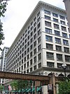
The Auditorium Building in Chicago is one of the best-known designs of Louis Sullivan and Dankmar Adler. Completed in 1889, the building is located at the northwest corner of South Michigan Avenue and Ida B. Wells Drive. The building was designed to be a multi-use complex, including offices, a theater, and a hotel. As a young apprentice, Frank Lloyd Wright worked on some of the interior design.

<span class="mw-page-title-main">Reliance Building</span> United States historic place

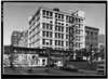
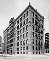
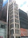
The Reliance Building is a skyscraper located at 1 W. Washington Street in the Loop community area of Chicago, Illinois. The first floor and basement were designed by John Root of the Burnham and Root architectural firm in 1890, with the rest of the building completed by Charles B. Atwood in 1895. It is the first skyscraper to have large plate glass windows make up the majority of its surface area, foreshadowing a design feature that would become dominant in the 20th century.

<span class="mw-page-title-main">National Register of Historic Places listings in Illinois</span>

This is a list of properties and districts in Illinois that are on the National Register of Historic Places. There are over 1,900 in total. Of these, 85 are National Historic Landmarks. There are listings in all of the state's 102 counties.
     This National Park Service list is complete through NPS recent listings posted January 12, 2024.

This is a list of the 133 National Register of Historic Places listings in Cook County, Illinois outside Chicago and Evanston. Separate lists are provided for the 62 listed properties and historic districts in Evanston and the more than 350 listed properties and districts in in Chicago. The Chicago Sanitary and Ship Canal Historic District extends through the West Side of Chicago, DuPage County and Will County to Lockport.

<span class="mw-page-title-main">Sullivan Center</span> United States historic place

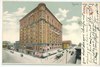
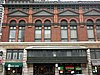
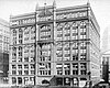
The Sullivan Center, formerly known as the Carson, Pirie, Scott and Company Building or Carson, Pirie, Scott and Company Store, is a commercial building at 1 South State Street at the corner of East Madison Street in Chicago, Illinois. Louis Sullivan designed it for the retail firm Schlesinger & Mayer in 1899 and later expanded it before H.G. Selfridge & Co. purchased the structure in 1904. That firm occupied the structure for only a matter of weeks before it sold the building to Otto Young, who then leased it to Carson Pirie Scott for $7,000 per month, which occupied the building for more than a century until 2006. Subsequent additions were completed by Daniel Burnham in 1906 and Holabird & Root in 1961.

There are more than 350 places listed on the United States National Register of Historic Places in Chicago, Illinois, including 83 historic districts that may include numerous historic buildings, structures, objects and sites. This total is documented in the tables referenced below. Tables of these listings may be found in the following articles:

<span class="mw-page-title-main">Pullman National Historical Park</span> Historic district and national monument in Chicago

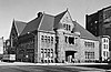
Pullman National Historical Park is a historic district located in Chicago, Illinois, United States, which in the 19th century was the first model, planned industrial community in the United States. The district had its origins in the manufacturing plans and organization of the Pullman Company and became one of the most well-known company towns in the United States, as well as the scene of the violent 1894 Pullman strike. It was built for George Pullman as a place to produce the Pullman railroad-sleeping cars.

<span class="mw-page-title-main">Grand Canyon Village Historic District</span> Historic district in Arizona, United States

Grand Canyon Village Historic District comprises the historic center of Grand Canyon Village, on the South Rim of the Grand Canyon in Grand Canyon National Park, Arizona. The district includes numerous landmark park structures, many of which are National Historic Landmarks themselves, or are listed on the National Register of Historic Places. The town design as a whole is also significant for its attention to integration with the Grand Canyon landscape, its incorporation of National Park Service Rustic design elements, and for the idiosyncratic design of park concessioner structures such as the El Tovar Hotel.

<span class="mw-page-title-main">Loop Retail Historic District</span> Historic district in Illinois, United States

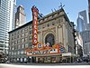
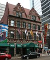
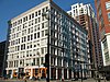
Loop Retail Historic District is a shopping district within the Chicago Loop community area in Cook County, Illinois, United States. It is bounded by Lake Street to the north, Ida B. Wells Drive to the south, State Street to the west and Wabash Avenue to the east. The district has the highest density of National Historic Landmark, National Register of Historic Places and Chicago Landmark designated buildings in Chicago. It hosts several historic buildings including former department store flagship locations Marshall Field and Company Building, and the Sullivan Center. It was added to the National Register of Historic Places on November 27, 1998. It includes 74 contributing buildings and structures, including 13 separately listed Registered Historic Places, and 22 non-contributing buildings. Other significant buildings in the district include the Joffrey Tower, Chicago Theatre, Palmer House, and Page Brothers Building. It also hosts DePaul University's College of Commerce, which includes the Kellstadt Graduate School of Business and the Robert Morris College.

<span class="mw-page-title-main">National Register of Historic Places listings in Detroit</span>

This is a list of the National Register of Historic Places listings in Detroit, Michigan.

There are 72 sites in the National Register of Historic Places listings in West Side, Chicago, out of more than 350 listings in the City of Chicago. The West Side is defined for this article as the area north of the Chicago Sanitary and Ship Canal, south of Fullerton Avenue, west of the Chicago River and east of the western city limits. One site, Logan Square Boulevards Historic District, spans a border and is included also in listings on the North Side. The Chicago Sanitary and Ship Canal Historic District extends through Cook County west of Chicago, DuPage County and Will County to Lockport.

There are 104 sites on the National Register of Historic Places listings in South Side Chicago — of more than 350 total listings within the City of Chicago, in Cook County, Illinois.

There are 96 sites in the National Register of Historic Places listings in North Side Chicago — of more than 350 listings within the City of Chicago, in Cook County, Illinois.

This is a list of the National Register of Historic Places listings in Cuyahoga Valley National Park.

<span class="mw-page-title-main">National Register of Historic Places listings in Downtown and Midtown Detroit</span>

This is a list of the National Register of Historic Places listings in Downtown and Midtown Detroit, Michigan. It is intended to be a complete list of the properties and districts on the National Register of Historic Places in Downtown and Midtown neighborhoods in Detroit, Michigan, United States. Latitude and longitude coordinates are provided for many National Register properties and districts; these locations may be seen together in online maps.

Edward Emmett Dougherty, a.k.a. Edwin Dougherty was an architect in the southeastern United States. One of his best known designs was the Tennessee War Memorial Auditorium in Nashville in 1922. The work won state and national design competitions.

<span class="mw-page-title-main">National Register of Historic Places listings in Carson County, Texas</span>

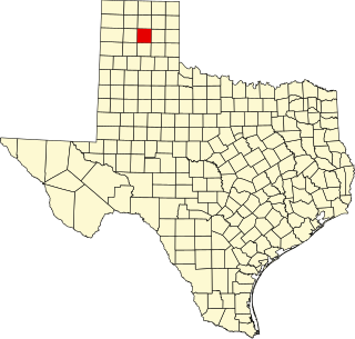
This is a list of the National Register of Historic Places listings in Carson County, Texas.

<span class="mw-page-title-main">Urbana-Lincoln Hotel-Lincoln Square Mall</span> United States historic place

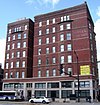
The Urbana-Lincoln Hotel – Lincoln Square Mall is a historic building complex located at 300 South Broadway Avenue in Urbana, Illinois. The Tudor Revival style hotel was built in 1923. In 1964, the mall was built as an extension of the hotel; it was one of the first fully enclosed shopping malls in Illinois. The hotel, the mall, and the building complex was listed on the National Register of Historic Places in 2006. As of October 2017, the mall was still in operation, however the hotel was closed.

<span class="mw-page-title-main">Columbus Landmarks</span> Historic preservation foundation in Ohio

The Columbus Landmarks Foundation, known as Columbus Landmarks, is a nonprofit historic preservation organization in Columbus, Ohio. The foundation is best-known for its list of endangered sites in the city and its annual design award, given to buildings, landscapes, and other sites created or renovated in Columbus. It was established in 1977 as a project of the Junior League of Columbus, Ohio, following the demolition of the city's historic Union Station. It is headquartered at 57 Jefferson Avenue, a contributing structure in the Jefferson Avenue Historic District in Downtown Columbus.

References

  1. The retailing sites are: Montgomery Ward Company Complex, Marshall Field Company Store, and Carson, Pirie, Scott and Company Building
  2. Hotels: 6 sites have "hotel" in their name.
  3. The four NRHP sites that are theaters are: the Auditorium Building, Balaban and Katz Chicago Theatre, the New Masonic Building and Oriental Theater and Orchestra Hall,
  4. National Park Service, United States Department of the Interior, "National Register of Historic Places: Weekly List Actions", retrieved January 12, 2024.
  5. 1 2 Numbers represent an alphabetical ordering by significant words. Various colorings, defined here, differentiate National Historic Landmarks and historic districts from other NRHP buildings, structures, sites or objects.
  6. "National Register Information System". National Register of Historic Places . National Park Service. April 24, 2008.
  7. The eight-digit number below each date is the number assigned to each location in the National Register Information System database, which can be viewed by clicking the number.
  8. 36 FR 23258
  9. National Archives
  10. "The Lexington Hotel". Buildings. The South Loop Historical Society. Archived from the original on 11 December 2011. Retrieved 15 September 2012.