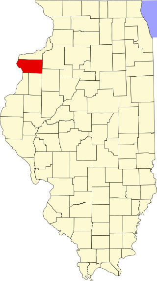
[2] Name on the Register [3] Image Date listed [4] Location Neighborhood Description 1 7th District Police Station 7th District Police Station May 2, 1996 (# 96000515 943-949 W. Maxwell Street 41°51′52″N 87°39′02″W / 41.864444°N 87.650556°W / 41.864444; -87.650556 (7th District Police Station ) Near West Side Built in 1888. Romanesque Revival police station that served in pacifying the "Bloody Maxwell" area from 1888 to 1988. [5] 2 Austin Historic District Austin Historic District August 8, 1985 (# 85001741 Roughly bounded by W. Ohio Street , N. Waller Avenue, N. Parkside Avenue, W. West End Avenue, & N. Mayfield Avenue & W. Corcoran Place 41°53′12″N 87°46′12″W / 41.886667°N 87.77°W / 41.886667; -87.77 (Austin Historic District ) Austin 3 Austin Town Hall Park Historic District Austin Town Hall Park Historic District November 15, 2006 (# 06001015 Roughly bounded by W. Lake Street , N. Central Avenue, N. Parkside Avenue, and W. Race Avenue 41°53′18″N 87°45′57″W / 41.888333°N 87.765833°W / 41.888333; -87.765833 (Austin Town Hall Park Historic District ) Austin 4 Automatic Electric Company Building Automatic Electric Company Building November 20, 2002 (# 02001386 1001 W. Van Buren Street 41°52′35″N 87°39′08″W / 41.8763889°N 87.6522222°W / 41.8763889; -87.6522222 (Automatic Electric Company Building ) Near West Side 5 Building at 900 West Lake Street Building at 900 West Lake Street February 12, 1999 (# 99000163 900 W. Lake Street 41°53′09″N 87°39′00″W / 41.885833°N 87.65°W / 41.885833; -87.65 (Building at 900 West Lake Street ) Near West Side 6 Central Park Theater Central Park Theater August 10, 2005 (# 05000873 3535 W. Roosevelt Road 41°51′59″N 87°42′26″W / 41.866389°N 87.707222°W / 41.866389; -87.707222 (Central Park Theater ) North Lawndale 7 Cermak Road Bridge Historic District Cermak Road Bridge Historic District May 1, 2012 (# 12000243 W. Cermak Road . & the South Branch of the Chicago River 41°51′10″N 87°38′26″W / 41.852717°N 87.640522°W / 41.852717; -87.640522 (Cermak Road Bridge Historic District ) Lower West Side 8 Anton Cermak House Anton Cermak House February 4, 2011 (# 10001201 2348 S. Millard Avenue 41°50′54″N 87°42′59″W / 41.848333°N 87.716389°W / 41.848333; -87.716389 (Anton Cermak House ) South Lawndale Former home of Chicago Mayor Anton Cermak 9 Chicago and North Western Railway Power House Chicago and North Western Railway Power House December 10, 2004 (# 04001306 211 N. Clinton Street 41°53′11″N 87°38′28″W / 41.886432°N 87.641183°W / 41.886432; -87.641183 (Chicago and North Western Railway Power House ) Near West Side 10 Chicago Park Boulevard System Historic District Chicago Park Boulevard System Historic District December 18, 2018 (# 12000040 Douglass Park , Gage, McKinley Park, Jackson Park , Sherman Park , Washington Park , Garfield Park & Humboldt Parks , E. Oakwood, S. Drexel Boulevards Coordinates missing 11 Chicago Sanitary and Ship Canal Historic District Chicago Sanitary and Ship Canal Historic District December 20, 2011 (# 11000907 Illinois Waterway miles 290.0-321.7 41°50′05″N 87°41′42″W / 41.834669°N 87.694889°W / 41.834669; -87.694889 (Chicago Sanitary and Ship Canal Historic District ) Lower West Side and South Lawndale part of the Illinois Waterway Navigation System Facilities MPS ; extends through Cook County west of Chicago , DuPage County and Will County to Lockport 12 Chicago Telephone Company Kedzie Exchange Chicago Telephone Company Kedzie Exchange May 30, 2001 (# 01000594 17 S. Homan Avenue 41°52′49″N 87°42′39″W / 41.880278°N 87.710833°W / 41.880278; -87.710833 (Chicago Telephone Company Kedzie Exchange ) East Garfield Park 13 Church of the Epiphany Church of the Epiphany February 5, 1998 (# 98000067 201 S. Ashland Avenue 41°52′43″N 87°39′59″W / 41.878611°N 87.666389°W / 41.878611; -87.666389 (Church of the Epiphany ) Near West Side 14 Columbus Park Columbus Park May 20, 1991 (# 91000567 500 S. Central Avenue 41°52′28″N 87°46′10″W / 41.874444°N 87.769444°W / 41.874444; -87.769444 (Columbus Park ) Austin 15 Cook County Hospital Administration Building Cook County Hospital Administration Building November 8, 2006 (# 06001017 1835 W. Harrison Street 41°52′33″N 87°40′22″W / 41.875833°N 87.672778°W / 41.875833; -87.672778 (Cook County Hospital Administration Building ) Near West Side 16 Creamery Package Manufacturing Company Building Creamery Package Manufacturing Company Building November 8, 2011 (# 11000778 1245 W. Washington Boulevard 41°52′58″N 87°39′30″W / 41.882778°N 87.658333°W / 41.882778; -87.658333 (Creamery Package Manufacturing Company Building ) Near West Side 17 Dawson Brothers Plant Dawson Brothers Plant February 14, 1985 (# 85000265 517-519 N. Halsted Street 41°53′31″N 87°38′50″W / 41.891944°N 87.647222°W / 41.891944; -87.647222 (Dawson Brothers Plant ) West Town 18 East Village Historic District East Village Historic District December 8, 2009 (# 09000459 Bounded by W. Division Street , W. Chicago Avenue , N. Hermitage Avenue and N. Damen Avenue 41°53′59″N 87°40′26″W / 41.899633°N 87.673781°W / 41.899633; -87.673781 (East Village Historic District ) West Town 19 First Congregational Church of Austin First Congregational Church of Austin November 17, 1977 (# 77000474 5701 W. Midway Park 41°53′19″N 87°46′05″W / 41.888611°N 87.768056°W / 41.888611; -87.768056 (First Congregational Church of Austin ) Austin 20 Lucy Flower Technical High School for Girls Lucy Flower Technical High School for Girls May 8, 2017 (# 100000960 3545 W. Fulton Boulevard 41°53′11″N 87°42′56″W / 41.886301°N 87.715442°W / 41.886301; -87.715442 (Lucy Flower Technical High School for Girls ) East Garfield Park 21 Jennie Foley Building Jennie Foley Building June 19, 1985 (# 85001274 626-628 S. Racine Avenue 41°52′24″N 87°39′25″W / 41.873333°N 87.656944°W / 41.873333; -87.656944 (Jennie Foley Building ) Near West Side 22 Garfield Park Garfield Park August 31, 1993 (# 93000837 100 N. Central Park Avenue 41°53′11″N 87°42′58″W / 41.886389°N 87.716111°W / 41.886389; -87.716111 (Garfield Park ) East Garfield Park 23 Abraham Groesbeck House Abraham Groesbeck House February 4, 1993 (# 92001841 1304 W. Washington Boulevard 41°52′59″N 87°39′36″W / 41.883056°N 87.66°W / 41.883056; -87.66 (Abraham Groesbeck House ) Near West Side 24 Guyon Hotel Guyon Hotel May 9, 1985 (# 85000966 4000 W. Washington Boulevard 41°52′55″N 87°43′35″W / 41.881944°N 87.726389°W / 41.881944; -87.726389 (Guyon Hotel ) West Garfield Park 25 Holy Trinity Russian Orthodox Cathedral and Rectory Holy Trinity Russian Orthodox Cathedral and Rectory March 16, 1976 (# 76000693 1117-1127 N. Leavitt Street 41°54′07″N 87°40′55″W / 41.901944°N 87.681944°W / 41.901944; -87.681944 (Holy Trinity Russian Orthodox Cathedral and Rectory ) West Town 26 Home Bank and Trust Company Home Bank and Trust Company February 21, 2007 (# 07000061 1200 N. Ashland Avenue 41°54′14″N 87°40′05″W / 41.903889°N 87.668056°W / 41.903889; -87.668056 (Home Bank and Trust Company ) West Town 27 Hull House Hull House October 15, 1966 (# 66000315 800 S. Halsted Street 41°52′17″N 87°38′49″W / 41.871389°N 87.646944°W / 41.871389; -87.646944 (Hull House ) Near West Side 28 Humboldt Park Humboldt Park February 20, 1992 (# 92000074 Roughly bounded by N. Sacramento Boulevard and W. Augusta Boulevard , and N. Kedzie Avenue , W. North Avenue and N. California Avenue and W. Division Street 41°54′12″N 87°42′10″W / 41.903333°N 87.702778°W / 41.903333; -87.702778 (Humboldt Park ) West Town 29 Immanuel Lutheran Church and Parsonage Upload image April 15, 2024 (# 100010215 1124-1134 South Ashland Avenue 41°52′03″N 87°40′00″W / 41.8676°N 87.6666°W / 41.8676; -87.6666 (Immanuel Lutheran Church and Parsonage ) 30 International Tailoring Company Building International Tailoring Company Building April 18, 2008 (# 07001474 847 W. Jackson Boulevard 41°52′40″N 87°38′57″W / 41.877706°N 87.649142°W / 41.877706; -87.649142 (International Tailoring Company Building ) Near West Side 31 Jewish People's Institute Jewish People's Institute November 15, 1978 (# 78001122 3500 W. Douglas Boulevard 41°51′47″N 87°42′47″W / 41.863056°N 87.713056°W / 41.863056; -87.713056 (Jewish People's Institute ) North Lawndale 32 K-Town Historic District K-Town Historic District September 9, 2010 (# 10000724 Bounded on the north by W. Cullerton Street; on the south by W. Cermak Road , on the west by S. Kostner Avenue, and on the east by S. Pulaski Road 41°51′11″N 87°43′47″W / 41.853056°N 87.729722°W / 41.853056; -87.729722 (K-Town Historic District ) North Lawndale 33 Patrick J. King House Patrick J. King House February 10, 1983 (# 83000311 3234 W. Washington Boulevard 41°52′58″N 87°42′27″W / 41.882778°N 87.7075°W / 41.882778; -87.7075 (Patrick J. King House ) East Garfield Park 34 Laramie State Bank Building Upload image April 20, 2023 (# 100008873 5200 W. Chicago Avenue 41°53′42″N 87°45′21″W / 41.8950°N 87.7558°W / 41.8950; -87.7558 (Laramie State Bank Building ) Austin 35 Henry E. Legler Regional Branch of the Chicago Public Library Henry E. Legler Regional Branch of the Chicago Public Library November 6, 1986 (# 86003169 115 S. Pulaski Road 41°52′46″N 87°43′31″W / 41.879444°N 87.725278°W / 41.879444; -87.725278 (Henry E. Legler Regional Branch of the Chicago Public Library ) West Garfield Park 36 Lindemann and Hoverson Company Showroom and Warehouse Lindemann and Hoverson Company Showroom and Warehouse November 26, 2008 (# 08001095 2620 W. Washington Boulevard 41°52′59″N 87°41′31″W / 41.882944°N 87.692056°W / 41.882944; -87.692056 (Lindemann and Hoverson Company Showroom and Warehouse ) East Garfield Park 37 Logan Square Boulevards Historic District Logan Square Boulevards Historic District November 20, 1985 (# 85002901 W. Logan Boulevard, Logan Square, N. Kedzie Boulevard , Palmer Square, and N. Humboldt Boulevard 41°55′16″N 87°42′16″W / 41.92112°N 87.704385°W / 41.92112; -87.704385 (Logan Square Boulevards Historic District ) Logan Square Three boulevards connected by two parks, on both the North Side and West Sides. 38 Lou Mitchell's Restaurant Lou Mitchell's Restaurant May 5, 2006 (# 06000376 565 W. Jackson Boulevard 41°52′38″N 87°38′30″W / 41.877222°N 87.641667°W / 41.877222; -87.641667 (Lou Mitchell's Restaurant ) Near West Side 39 Mid-City Trust and Savings Bank Upload image August 23, 2023 (# 100009254 801 W. Madison Street 41°52′54″N 87°38′51″W / 41.8817°N 87.6475°W / 41.8817; -87.6475 (Mid-City Trust and Savings Bank ) Near West Side 40 Midwest Athletic Club Midwest Athletic Club October 18, 1984 (# 84000138 6 N. Hamlin Avenue 41°52′52″N 87°43′16″W / 41.881111°N 87.721111°W / 41.881111; -87.721111 (Midwest Athletic Club ) West Garfield Park 41 John Lothrop Motley School John Lothrop Motley School September 5, 2017 (# 100001562 739 N. Ada Street 41°53′44″N 87°39′40″W / 41.895467°N 87.661124°W / 41.895467; -87.661124 (John Lothrop Motley School ) West Town 42 Notre Dame de Chicago Notre Dame de Chicago March 7, 1979 (# 79000826 1338 W. Flournoy Street 41°52′24″N 87°39′39″W / 41.873333°N 87.660833°W / 41.873333; -87.660833 (Notre Dame de Chicago ) Near West Side 43 Otis Elevator Company Factory Building Otis Elevator Company Factory Building November 26, 2008 (# 08001097 1435 W. 15th Street and 1501 S. Laflin Street 41°51′41″N 87°39′44″W / 41.861444°N 87.662278°W / 41.861444; -87.662278 (Otis Elevator Company Factory Building ) Near West Side 44 Elizabeth Peabody School Elizabeth Peabody School December 26, 2017 (# 100001923 1444 W. Augusta Boulevard 41°53′59″N 87°39′50″W / 41.899831°N 87.663755°W / 41.899831; -87.663755 (Elizabeth Peabody School ) West Town 45 Pilsen Historic District Pilsen Historic District February 1, 2006 (# 10240018 Roughly bounded by W. 16th Street, W. Cermak Road , S. Halsted Street and S. Western Avenue 41°51′14″N 87°40′13″W / 41.853889°N 87.670278°W / 41.853889; -87.670278 (Pilsen Historic District ) Lower West Side 46 Pioneer Trust and Savings Bank Pioneer Trust and Savings Bank September 21, 2023 (# 100009372 4000 W. North Avenue 41°54′36″N 87°43′35″W / 41.9100°N 87.7265°W / 41.9100; -87.7265 (Pioneer Trust and Savings Bank ) Humboldt Park 47 Polish National Alliance Headquarters Polish National Alliance Headquarters December 23, 2014 (# 14001063 1514-1520 W. Division Street 41°54′12″N 87°39′57″W / 41.9034°N 87.6658°W / 41.9034; -87.6658 (Polish National Alliance Headquarters ) West Town 48 Polish Roman Catholic Union of America Polish Roman Catholic Union of America January 2, 2013 (# 12001114 984 N. Milwaukee Avenue 41°53′58″N 87°39′40″W / 41.899582°N 87.661141°W / 41.899582; -87.661141 (Polish Roman Catholic Union of America ) West Town 49 Produce Terminal Cold Storage Company Building Produce Terminal Cold Storage Company Building June 22, 2003 (# 03000538 1550 S. Blue Island Avenue 41°51′38″N 87°39′35″W / 41.860610°N 87.659609°W / 41.860610; -87.659609 (Produce Terminal Cold Storage Company Building ) Near West Side 50 Pulaski Park and Fieldhouse Pulaski Park and Fieldhouse August 13, 1981 (# 81000217 1419 W. Blackhawk Street 41°54′21″N 87°39′47″W / 41.905833°N 87.663056°W / 41.905833; -87.663056 (Pulaski Park and Fieldhouse ) West Town 51 Pyle-National Company Plant Upload image January 19, 2021 (# 100006017 1334 N. Kostner Avenue 41°54′21″N 87°44′11″W / 41.9057°N 87.7363°W / 41.9057; -87.7363 (Pyle-National Company Plant ) Humboldt Park 52 St. Ignatius College St. Ignatius College November 17, 1977 (# 77000480 1076 W. Roosevelt Road 41°52′03″N 87°39′06″W / 41.8675°N 87.651667°W / 41.8675; -87.651667 (St. Ignatius College ) Near West Side 53 St. Matthew Evangelical Lutheran School St. Matthew Evangelical Lutheran School January 27, 2000 (# 99001710 2101-2107 W. 21st Street 41°51′13″N 87°40′43″W / 41.853611°N 87.678611°W / 41.853611; -87.678611 (St. Matthew Evangelical Lutheran School ) Lower West Side 54 St. Patrick's Roman Catholic Church St. Patrick's Roman Catholic Church July 15, 1977 (# 77000481 718 W. Adams Street 41°52′45″N 87°38′40″W / 41.879167°N 87.644444°W / 41.879167; -87.644444 (St. Patrick's Roman Catholic Church ) Near West Side 55 Schoenhofen Brewery Historic District Schoenhofen Brewery Historic District December 27, 1978 (# 78001128 Roughly bounded by W. 16th Street, W. 18th Street, S. Canal Street, and S. Clinton Street 41°51′31″N 87°38′22″W / 41.858611°N 87.639444°W / 41.858611; -87.639444 (Schoenhofen Brewery Historic District ) Lower West Side 56 Sears, Roebuck and Company Complex Sears, Roebuck and Company Complex June 2, 1978 (# 78001129 925 S. Homan Avenue 41°52′10″N 87°42′42″W / 41.869444°N 87.711667°W / 41.869444; -87.711667 (Sears, Roebuck and Company Complex ) North Lawndale 57 Shedd Park Fieldhouse Shedd Park Fieldhouse December 30, 1974 (# 74000755 3660 W. 23rd Street 41°51′01″N 87°43′01″W / 41.850278°N 87.716944°W / 41.850278; -87.716944 (Shedd Park Fieldhouse ) South Lawndale 58 J. P. Smith Shoe Company Plant J. P. Smith Shoe Company Plant November 14, 1985 (# 85002842 685 N. Sangamon Avenue and 911 W. Huron Street 41°53′41″N 87°39′03″W / 41.894722°N 87.650833°W / 41.894722; -87.650833 (J. P. Smith Shoe Company Plant ) West Town 59 South Water Market South Water Market August 20, 2004 (# 04000870 Bounded by W. 14th Place, the 16th Street rail embankment, S. Racine Avenue , and S. Morgan Street 41°51′42″N 87°39′15″W / 41.861667°N 87.654167°W / 41.861667; -87.654167 (South Water Market ) Near West Side 60 Stone Temple Baptist Church Upload image December 21, 2022 (# 100008484 3622 W. Douglas Boulevard 41°51′46″N 87°42′59″W / 41.8629°N 87.7163°W / 41.8629; -87.7163 (Stone Temple Baptist Church ) North Lawndale 61 Storkline Furniture Corporation Factory Storkline Furniture Corporation Factory March 6, 2013 (# 13000049 4400-4418 W. 26th Street 41°50′42″N 87°44′05″W / 41.844873°N 87.734741°W / 41.844873; -87.734741 (Storkline Furniture Corporation Factory ) South Lawndale Destroyed in a fire in 2016. [6] 62 Story-Camp Rowhouses Story-Camp Rowhouses May 8, 1980 (# 80001351 1526-1528 W. Monroe Street 41°52′48″N 87°39′57″W / 41.88°N 87.665833°W / 41.88; -87.665833 (Story-Camp Rowhouses ) Near West Side 63 Third Church of Christ, Scientist Third Church of Christ, Scientist October 24, 2016 (# 16000733 2151 W. Washington Boulevard 41°52′59″N 87°40′53″W / 41.883021°N 87.681288°W / 41.883021; -87.681288 (Third Church of Christ, Scientist ) Near West Side 64 Tri-Taylor Historic District Tri-Taylor Historic District March 3, 1983 (# 83000315 Roughly bounded by S. Claremont Avenue, W. Harrison Street, S. Oakley Avenue, W. Polk Street, W. Ogden Avenue , and W. Roosevelt Road ; also roughly bounded on the north by Oakley, Harrison, and Claremont Streets, and on the southeast by Taylor and Oakley Streets 41°52′13″N 87°41′00″W / 41.870278°N 87.683333°W / 41.870278; -87.683333 (Tri-Taylor Historic District ) Near West Side Second set of boundaries represents a boundary increase of February 3, 1988 65 Union Park Congregational Church and Carpenter Chapel Union Park Congregational Church and Carpenter Chapel May 31, 2006 (# 06000446 1613 W. Washington Boulevard 41°53′06″N 87°40′03″W / 41.885°N 87.6675°W / 41.885; -87.6675 (Union Park Congregational Church and Carpenter Chapel ) Near West Side Now known as First Baptist Congregational Church; built in 1871; severely damaged in the February 2, 2011 blizzard [7] 66 Union Park Hotel Union Park Hotel June 7, 2010 (# 10000309 1519-1521 W. Warren Boulevard 41°52′56″N 87°39′58″W / 41.882117°N 87.666117°W / 41.882117; -87.666117 (Union Park Hotel ) Near West Side 67 United States Customs House United States Customs House August 4, 2016 (# 16000492 610 S. Canal Street 41°52′27″N 87°38′23″W / 41.874032°N 87.639589°W / 41.874032; -87.639589 (United States Customs House ) Near West Side 68 United States Post Office-Chicago United States Post Office-Chicago August 16, 2001 (# 01000868 433 W. Van Buren Street 41°52′34″N 87°38′19″W / 41.876111°N 87.638611°W / 41.876111; -87.638611 (United States Post Office-Chicago ) Near West Side 69 Joseph J. Walser House Joseph J. Walser House April 23, 2013 (# 13000185 42 N. Central Avenue 41°52′54″N 87°45′55″W / 41.881528°N 87.765286°W / 41.881528; -87.765286 (Joseph J. Walser House ) Austin Frank Lloyd Wright , 1903 70 Seth Warner House Seth Warner House June 3, 1982 (# 82002531 631 N. Central Avenue 41°53′31″N 87°45′54″W / 41.891944°N 87.765°W / 41.891944; -87.765 (Seth Warner House ) Austin 71 West Jackson Boulevard District West Jackson Boulevard District May 19, 1978 (# 78001134 Roughly bounded by S. Laflin Avenue, S. Ashland Avenue , W. Adams Street, and W. Van Buren Street ; also 1513 W. Adams Street 41°52′39″N 87°39′55″W / 41.8775°N 87.665278°W / 41.8775; -87.665278 (West Jackson Boulevard District ) Near West Side Second set of boundaries represents a boundary increase of October 19, 1989 72 Wholesale Florists Exchange Wholesale Florists Exchange November 22, 2011 (# 11000849 1313 W. Randolph Street 41°53′03″N 87°39′34″W / 41.884167°N 87.659444°W / 41.884167; -87.659444 (Wholesale Florists Exchange ) Near West Side 73 Wicker Park Historic District Wicker Park Historic District June 20, 1979 (# 79000831 Roughly bounded by N. Wood Street, W. Crystal Street, N. Caton Street, N. Claremont Avenue and W. North Avenue 41°54′26″N 87°40′20″W / 41.907222°N 87.672222°W / 41.907222; -87.672222 (Wicker Park Historic District ) West Town