North Canaan, Connecticut

Last updated

North Canaan, Connecticut
Town of North Canaan
Union Depot, North Canaan CT.jpg
Union Depot
NorthCanaanCTseal.gif
Litchfield County Connecticut Incorporated and Unincorporated areas North Canaan Highlighted 2010.svg
North Canaan, Connecticut
Coordinates: 42°01′21″N73°17′27″W / 42.02250°N 73.29083°W / 42.02250; -73.29083
CountryFlag of the United States.svg  United States
U.S. state Flag of Connecticut.svg  Connecticut
County Litchfield
Region Northwest Hills
Incorporated1858
Government
  Type Selectman-town meeting
  First selectmanCharles P. Perotti
  SelectmanCraig Whiting
  SelectmanChristian P. Allyn
Area
  Total19.5 sq mi (50.5 km2)
  Land19.5 sq mi (50.4 km2)
  Water0.0 sq mi (0.0 km2)
Elevation
823 ft (251 m)
Population
 (2020)
  Total3,211
  Density165/sq mi (63.7/km2)
Time zone UTC-5 (Eastern)
  Summer (DST) UTC-4 (Eastern)
ZIP codex
06018, 06024
Area code(s) 860/959
FIPS code 09-54030
GNIS feature ID0213478
Website www.northcanaan.org

North Canaan is a town in Litchfield County, Connecticut, United States. The population was 3,211 at the 2020 census. [1] The town is part of the Northwest Hills Planning Region. The town center is still called "Canaan", being the main town center of the old town of Canaan prior to North Canaan splitting off as its own town.

Contents

Geography

North Canaan is in northwestern Litchfield County and is bordered to the north by Berkshire County, Massachusetts. According to the United States Census Bureau, the town has a total area of 19.5 square miles (50.4 km2), of which 0.01 square miles (0.02 km2), or 0.03%, are water. [2]

Principal communities

Demographics

Historical population
CensusPop.Note
1860 1,426
1870 1,69518.9%
1880 1,537−9.3%
1890 1,6839.5%
1900 1,8037.1%
1910 2,17120.4%
1920 1,933−11.0%
1930 2,28718.3%
1940 2,3040.7%
1950 2,64714.9%
1960 2,8367.1%
1970 3,0457.4%
1980 3,1854.6%
1990 3,2843.1%
2000 3,3502.0%
2010 3,315−1.0%
2020 3,211−3.1%
U.S. Decennial Census [4]

As of the census [5] of 2000, there were 3,350 people, 1,343 households, and 864 families residing in the town. The population density was 172.2 inhabitants per square mile (66.5/km2). There were 1,444 housing units at an average density of 74.2 per square mile (28.6/km2). The racial makeup of the town was 96.93% White, 1.19% African American, 0.18% Native American, 0.18% Asian, 0.39% from other races, and 1.13% from two or more races. Hispanic or Latino of any race were 2.36% of the population.

There were 1,343 households, out of which 30.0% had children under the age of 18 living with them, 50.4% were married couples living together, 9.9% had a female householder with no husband present, and 35.6% were non-families. 30.2% of all households were made up of individuals, and 13.9% had someone living alone who was 65 years of age or older. The average household size was 2.38 and the average family size was 2.98.

In the town, the population was spread out, with 23.3% under the age of 18, 6.7% from 18 to 24, 28.1% from 25 to 44, 22.9% from 45 to 64, and 19.0% who were 65 years of age or older. The median age was 40 years. For every 100 females, there were 92.6 males. For every 100 females age 18 and over, there were 89.1 males.

The median income for a household in the town was $39,020, and the median income for a family was $52,292. Males had a median income of $34,135 versus $23,705 for females. The per capita income for the town was $18,971. About 3.3% of families and 5.8% of the population were below the poverty line, including 3.1% of those under age 18 and 5.0% of those age 65 or over.

Transportation

The main highways of the town are U.S. Route 7 (north-south) and U.S. Route 44 (east-west). US 7 leads north 13 miles (21 km) to Great Barrington, Massachusetts, and south 54 miles (87 km) to Danbury, while US 44 leads west 12 miles (19 km) to Millerton, New York, and east 42 miles (68 km) to Hartford, the capital of Connecticut.

The Housatonic Railroad north-south tracks run through the town on their Danbury, to Pittsfield, Massachusetts, line. [6]

A private airfield, Triumph Air Field, is situated to the northwest of the village. [7]

Economy

Downtown Canaan Village is centered around the intersection of the former Central New England Railroad east-west tracks crossed with the active Housatonic Railroad north-south tracks. [6] The village contains a variety of retail, restaurant, and other businesses.

The Canaan Union Depot building, a former railroad station built in 1872, is a prominent building in the downtown area. It was heavily damaged by an arson fire in 2001. From 2003 to 2018 it was restored by the Connecticut Railroad Historical Association. It is now the site of the Great Falls Brewing Company [8] and the New England Accordion Connection and Museum Company. [9]

East Canaan is known for its dairy farm operations and limestone mines. [6] In 2016, East Canaan dairy farm, Freund's Farm, became the first farm in Connecticut to use robotic milking units for their dairy herd. [10] The farm also produces CowPots™, a biodegradable plant pot made from composted cow manure. [11] [12]

Education

North Canaan is a member of Regional School District 01, which also includes the towns of Canaan, Cornwall, Kent, Salisbury, and Sharon. Public school students attend North Canaan Elementary School from grades K–8 and Housatonic Valley Regional High School in Falls Village from grades 9–12.

Notable people

Related Research Articles

<span class="mw-page-title-main">Kent, Connecticut</span> Town in Connecticut, United States

Kent is a town in Litchfield County, Connecticut, United States. Located alongside the border with New York, the town's population was 3,019 according to the 2020 census. The town is part of the Northwest Hills Planning Region. Kent is home to three boarding schools: Kent School, the Marvelwood School, and South Kent School. The Schaghticoke Indian Reservation is also located within town borders. The town was also home to former U.S. Secretary of State Henry Kissinger.

<span class="mw-page-title-main">Litchfield County, Connecticut</span> County in Connecticut, United States

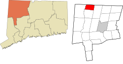
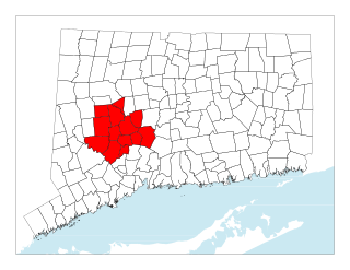
Litchfield County is in northwestern Connecticut, United States. As of the 2020 census, the population was 185,186. The county was named after Lichfield, in England. Litchfield County has the lowest population density of any county in Connecticut and is the state's largest county by area.

<span class="mw-page-title-main">Bridgewater, Connecticut</span> Town in Connecticut, United States

Bridgewater is a town in Litchfield County, Connecticut, United States. The population was 1,662 at the 2020 census, down from 1,727 at the 2010 census. The town is part of the Western Connecticut Planning Region.

<span class="mw-page-title-main">Cornwall, Connecticut</span> Town in Connecticut, United States

Cornwall is a town in Litchfield County, Connecticut, United States. The population was 1,567 at the 2020 census. The town is part of the Northwest Hills Planning Region.

<span class="mw-page-title-main">Goshen, Connecticut</span> Town in Connecticut, United States

Goshen is a town in Litchfield County, Connecticut, United States. The population was 3,150 at the 2020 census. The town is part of the Northwest Hills Planning Region.

<span class="mw-page-title-main">Harwinton, Connecticut</span> Town in Connecticut, United States

Harwinton is a town in Litchfield County, Connecticut, United States. The population was 5,484 at the 2020 census. The town is part of the Northwest Hills Planning Region. The high school is Lewis S. Mills.

<span class="mw-page-title-main">Norfolk, Connecticut</span> Town in Connecticut, United States

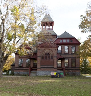
Norfolk is a town in Litchfield County, Connecticut, United States. The population was 1,588 at the 2020 census. The town is part of the Northwest Hills Planning Region. The urban center of the town is the Norfolk census-designated place, with a population of 553 at the 2010 census.

<span class="mw-page-title-main">Salisbury, Connecticut</span> Town in Connecticut, United States

Salisbury is a town situated in Litchfield County, Connecticut, United States. The town is the northwesternmost in the state of Connecticut; the Massachusetts-New York-Connecticut tri-state marker is located at the northwestern corner of the town. The population was 4,194 at the 2020 census. The town is part of the Northwest Hills Planning Region.

<span class="mw-page-title-main">Sharon, Connecticut</span> Town in Connecticut, United States

Sharon is a town in Litchfield County, Connecticut, United States, in the northwest corner of the state. At the time of the 2020 census, the town had a total population of 2,680. The town is part of the Northwest Hills Planning Region. The ZIP code for Sharon is 06069. The urban center of the town is the Sharon census-designated place, with a population of 729 at the 2010 census.

<span class="mw-page-title-main">Thomaston, Connecticut</span> Town in Connecticut, United States

Thomaston is a town in Litchfield County, Connecticut, United States. The town is part of the Naugatuck Valley Planning Region. The population was 7,442 at the 2020 census. The urban center of the town is the Thomaston census-designated place, with a population of 1,928 at the 2020 census.

<span class="mw-page-title-main">Sheffield, Massachusetts</span> Town in Massachusetts, United States

Sheffield is a town in Berkshire County, Massachusetts, United States. It is part of the Pittsfield, Massachusetts, Metropolitan Statistical Area. The population was 3,327 at the 2020 census. Sheffield is home to Berkshire School, a private preparatory school. The former resort town includes the village of Ashley Falls, and is bordered by various other towns and villages, such as Egremont and Great Barrington. Its southern border is the Massachusetts-Connecticut state line.

<span class="mw-page-title-main">Canaan, New York</span> Town in New York, United States

Canaan is a town in Columbia County, New York, United States. The population was 1,570 at the 2020 census, down from 1,710 at the 2010 census. The town is in the northeastern part of the county.

<span class="mw-page-title-main">Canaan, Vermont</span> Town in Vermont, United States

Canaan is a town in Essex County, Vermont, United States. The population was 896 at the 2020 census. Canaan contains the village of Beecher Falls, located at the confluence of the Connecticut River and Halls Stream. It is part of the Berlin, NH-VT Micropolitan Statistical Area.

<span class="mw-page-title-main">New Milford (CDP), Connecticut</span> Census-designated place in Connecticut, United States

Downtown New Milford is a district/census-designated place (CDP) in Litchfield County, Connecticut, United States. It comprises the main population center within the town of New Milford. As of the 2010 census, the population of Downtown New Milford was 6,523, out of 28,142 in the entire town of New Milford.

<span class="mw-page-title-main">New Milford, Connecticut</span> Town in Connecticut, United States

New Milford is a town in Litchfield County, Connecticut, United States. The town, part of Greater Danbury, as well as the New York Metropolitan Area, has a population of 28,115 as of the 2020 census. New Milford lies 14 miles (23 km) north of Danbury on the banks of the Housatonic River, and shares its border with the northeastern shore of Candlewood Lake. It is the largest town in the state of Connecticut in terms of land area at nearly 63.7 mi2 (164.9822 km2). The town center is listed as a census-designated place (CDP).

<span class="mw-page-title-main">Falls Village, Connecticut</span> Census-designated place in Connecticut, United States

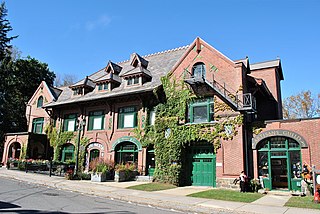
Falls Village is a village and census-designated place in the town of Canaan in Litchfield County, Connecticut, United States. As of the 2010 census it had a population of 538, out of 1,234 in the entire town of Canaan. Because Falls Village is the town center and principal constituent village in Canaan, the entire town is often referred to as "Falls Village". That usage also avoids confusion of the town with Canaan Village in the town of North Canaan, Connecticut, just to the north. Falls Village derives its name from a waterfall, known as Great Falls, on the Housatonic River within the village.

<span class="mw-page-title-main">Central Naugatuck Valley</span> Place in Connecticut, United States

The Central Naugatuck Valley is a region of Connecticut in New Haven and Litchfield counties located approximately 70 miles (110 km) northeast of New York City and 110 miles (180 km) southwest of Boston, United States. The region comprises 13 towns: Beacon Falls, Bethlehem, Cheshire, Middlebury, Naugatuck, Oxford, Prospect, Southbury, Thomaston, Waterbury, Watertown, Wolcott, and Woodbury.

<span class="mw-page-title-main">Canaan, Connecticut</span> Town in Connecticut, United States

Canaan is a town in Litchfield County, Connecticut, United States. The population was 1,080 at the 2020 census, down from 1,234 at the 2010 census. The town is part of the Northwest Hills Planning Region. The town of Canaan is often referred to locally by the name of its principal settlement, Falls Village.

<span class="mw-page-title-main">Canaan (village), Connecticut</span> United States historic place

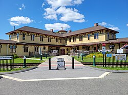
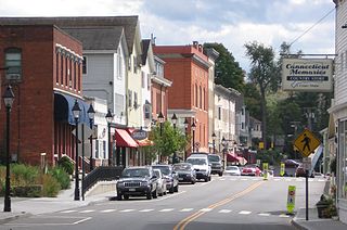
Canaan is a village and census-designated place (CDP) within the town of North Canaan in Litchfield County, Connecticut, United States. Formerly known as Canaan Depot, the village is more commonly known as Canaan Village to distinguish it from the town of Canaan located to the south of North Canaan. The Canaan Village Historic District is listed on the National Register of Historic Places. As of the 2010 census, the CDP had a population of 1,212, out of a total population of 3,315 in the town of North Canaan.

<span class="mw-page-title-main">Norfolk (CDP), Connecticut</span> Census-designated place in Connecticut, United States

Norfolk is a census-designated place (CDP) in Litchfield County, Connecticut, United States. It is the central village within the town of Norfolk. As of the 2010 census, the population of the CDP was 553, out of 1,709 in the entire town.

References

  1. "Census - Geography Profile: North Canaan town, Litchfield County, Connecticut". United States Census Bureau . Retrieved December 18, 2021.
  2. "Geographic Identifiers: 2010 Census Summary File 1 (G001), North Canaan town, Litchfield County, Connecticut". American FactFinder. U.S. Census Bureau. Archived from the original on February 13, 2020. Retrieved October 9, 2019.
  3. Douthat, Strat (September 26, 1992). "Connecticut's Sodom gone, but not forgotten". Gainesville Sun. pp. 6D. Retrieved May 26, 2015.
  4. "Census of Population and Housing". Census.gov. Retrieved June 4, 2015.
  5. "U.S. Census website". United States Census Bureau . Retrieved January 31, 2008.
  6. 1 2 3 "About Us | North Canaan, CT". www.northcanaan.org. Retrieved March 31, 2024.
  7. "AirNav: CT24 - North Canaan Aviation Facilities Inc Airport". www.airnav.com. Retrieved March 31, 2024.
  8. MainStreetMag (May 1, 2018). "The Canaan Depot". Main Street Magazine. Retrieved March 31, 2024.
  9. Walsh, Michael (September 29, 2021). "North Canaan accordion museum features 400 instruments and just as many stories".
  10. Press, Associated (July 18, 2015). "First Robotic Parlor Coming to Connecticut Next Spring". Dairy Herd. Retrieved March 31, 2024.
  11. "The Freund Family". NMPF. Retrieved March 31, 2024.
  12. US EPA, OAR (September 14, 2017). "Project Profile: Freund's Farm, Inc". www.epa.gov. Retrieved March 31, 2024.