North Carolina Highway 274

Last updated

NC 274.svg

North Carolina Highway 274
NC 274 map.svg
Route information
Maintained by NCDOT
Length36.7 mi [1] (59.1 km)
Existed1930–present
Major junctions
South endSouth Carolina 274.svg SC 274 at the South Carolina line near Lake Wylie, SC
 US 29.svgUS 74.svg US 29 / US 74 in Gastonia
US 321.svg US 321 in Gastonia
I-85.svg I-85 in Gastonia
North endNC 27.svg NC 27 in Hulls Crossroads
Location
Counties Gaston, Lincoln
Highway system
NC 273.svg NC 273 NC 275 NC 275.svg

North Carolina Highway 274 (NC 274) is a primary state highway in the U.S. state of North Carolina. It connects rural areas of Lincoln and Gaston counties to Gastonia.

A state highway, state road, or state route is usually a road that is either numbered or maintained by a sub-national state or province. A road numbered by a state or province falls below numbered national highways in the hierarchy. Roads maintained by a state or province include both nationally numbered highways and un-numbered state highways. Depending on the state, "state highway" may be used for one meaning and "state road" or "state route" for the other.

North Carolina State of the United States of America

North Carolina is a state in the southeastern region of the United States. It borders South Carolina and Georgia to the south, Tennessee to the west, Virginia to the north, and the Atlantic Ocean to the east. North Carolina is the 28th-most extensive and the 9th-most populous of the U.S. states. The state is divided into 100 counties. The capital is Raleigh, which along with Durham and Chapel Hill is home to the largest research park in the United States. The most populous municipality is Charlotte, which is the second-largest banking center in the United States after New York City.

Lincoln County, North Carolina County in the United States

Lincoln County is a county located in the U.S. state of North Carolina. As of the 2010 census, the population was 78,265. Its county seat is Lincolnton. Lincoln County is included in the Charlotte-Concord-Gastonia, NC-SC Metropolitan Statistical Area.

Contents

Route description

Directional signs of NC 274 at the end of NC 161 in Bessemer City NC161-NC274-Bessemer City.jpg
Directional signs of NC 274 at the end of NC 161 in Bessemer City

History

NC 274 was established in 1930 as a new primary routing, from NC 27 to U.S. Route 74 (US 74) and NC 20 (now NC 161) in Bessemer City. [2] Around 1938, it was extended southeast to its current southern terminus at the South Carolina state line, where it continues as South Carolina Highway 274 (SC 274). [3] Between 1963 and 1968, southbound lanes along Broad Street were added on west side of tracks in downtown Gastonia.[ citation needed ]

North Carolina Highway 27 highway in North Carolina

North Carolina Highway 27 (NC 27) is a primary state highway in the U.S. state of North Carolina. The route traverses 198 miles (319 km) through southern and central North Carolina, about 100 miles (160 km) of it as a concurrency with NC 24.

U.S. Route 74 (US 74) is an east–west United States highway that runs for 515 miles (829 km) from Chattanooga, Tennessee to Wrightsville Beach, North Carolina. Predominantly in North Carolina, it serves as an important highway from the mountains to the sea, connecting the cities of Asheville, Charlotte and Wilmington.

North Carolina Highway 20 highway in North Carolina

North Carolina Highway 20 is a 27-mile (43 km) North Carolina state highway that runs through Hoke, Robeson and Bladen counties. It serves as a major road in each of the three incorporated communities through which it passes. The route is co-designated as St. Pauls Road in Raeford, Main Street in Lumber Bridge, and Broad Street in St. Pauls.

Junction list

CountyLocationmi [1] kmDestinationsNotes
Gaston 0.00.0South Carolina 274.svg SC 274 east Lake Wylie South Carolina state line
Gastonia 10.316.6US 29.svgUS 74.svg US 29 north / US 74 east (Franklin Boulevard)North end of US 29 and east end of US 74 overlap
10.717.2US 321.svg US 321 (York Street / Chester Street)North-south US 321 divided on one-way streets
12.420.0US 29.svgUS 74.svg US 29 south / US 74 west (Franklin Boulevard) Spartanburg South end of US 29 and west end of US 74 overlap
13.922.4I-85.svg I-85  Charlotte, Kings Mountain
15.024.1NC 275.svg NC 275 east (Dallas-Bessemer City Highway) Dallas
Bessemer City 17.628.3NC 161.svg NC 161 south (13th Street) Kings Mountain
23.337.5NC 216.svg NC 216 south (County Line Road) Kings Mountain
Cherryville 26.642.8NC 150.svgNC 279.svg NC 150 (Church Street) to NC 279  Lincolnton, Shelby
Lincoln 31.049.9NC 182.svg NC 182  Lincolnton, Fallston
Hulls Crossroads 36.759.1NC 27.svg NC 27  Lincolnton, Morganton
1.000 mi = 1.609 km; 1.000 km = 0.621 mi

Related Research Articles

North Carolina Highway 75 highway in North Carolina

North Carolina Highway 75 (NC 75) is a primary state highway in the U.S. state of North Carolina. Its entire length runs through Union County and serves as the primary connector between the towns of Waxhaw, Mineral Springs, and Monroe. The route roughly parallels a CSX railroad line for its entire span.

North Carolina Highway 83 highway in North Carolina

North Carolina Highway 83 (NC 83) is a primary state highway in the U.S. state of North Carolina. It serves to connect the towns of Maxton and Clio, South Carolina.

North Carolina Highway 7 highway in North Carolina

North Carolina Highway 7 (NC 7) is a primary state highway in the U.S. state of North Carolina. Entirely within Gaston County, it connects the towns of Lowell, McAdenville, and Belmont with the city of Gastonia.

North Carolina Highway 8 highway in North Carolina

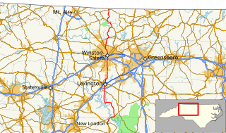
North Carolina Highway 8 (NC 8) is a primary state highway in the U.S. state of North Carolina. The route connects the cities of Lexington and Winston-Salem to various recreational and natural sites including Uwharrie National Forest, High Rock Lake and Hanging Rock State Park. NC 8 is part of a two-state, 151 mile highway 8 system.

North Carolina Highway 60 highway in North Carolina

North Carolina Highway 60 (NC 60) is a primary state highway in the extreme southwestern corner of North Carolina. The highway runs north–south from the Georgia state line to U.S. Route 64/U.S. Route 74 (US 64/US 74), near Ranger.

North Carolina Highway 68 highway in North Carolina

North Carolina Highway 68 (NC 68) is a north–south state highway in North Carolina. It serves as a connector between Interstate 40 (I-40)/ US 421 and Piedmont Triad International Airport. On its routing from Thomasville to Stokesdale, NC 68 passes through urban High Point, the western outskirts of Greensboro, and the town of Oak Ridge. The segment from just north of the I-40/US 421 interchange to Pleasant Ridge Road in Guilford County is a limited access freeway.

North Carolina Highway 242 highway in North Carolina

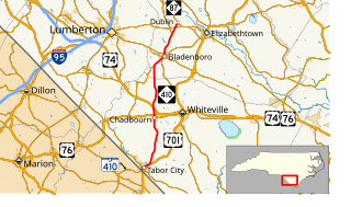
North Carolina Highway 242 (NC 242) is a primary state highway in the U.S. state of North Carolina. It traverses from Cerro Gordo to Benson, connecting the cities of Bladenboro, Elizabethtown, and Roseboro.

North Carolina Highway 43 highway in North Carolina

North Carolina Highway 43 (NC 43) is a primary state highway in the U.S. state of North Carolina. It connects many towns in the Coastal Plain region.

North Carolina Highway 306 highway in North Carolina

North Carolina Highway 306 (NC 306) is a primary state highway in the U.S. state of North Carolina. The highway provides a link between Havelock, Minnesott Beach, and Grantsboro. The route is primarily rural, and uses two free ferries to cross the Neuse and Pamlico Rivers before reaching NC 92/NC 99 near Gaylord.

North Carolina Highway 81 highway in North Carolina

North Carolina Highway 81 (NC 81) is a primary state highway in the U.S. state of North Carolina. That runs entirely in Asheville and Buncombe County from US 25 to US 70.

North Carolina Highway 61 highway in North Carolina

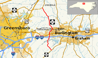
North Carolina Highway 61 (NC 61) is a primary state highway in the U.S. state of North Carolina. It serves as the main north–south highway in eastern Guilford County, connecting Whitsett and Gibsonville.

North Carolina Highway 171 highway in North Carolina

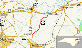
North Carolina Highway 171 (NC 171) is a primary state highway in the U.S. state of North Carolina. It utilized as a connector route running from US 17 in Old Ford between Washington and Williamston to US 64 Business in Jamesville.

North Carolina Highway 209 highway in North Carolina

North Carolina Highway 209 (NC 209) is a primary state highway in the U.S. state of North Carolina. The highway runs north–south from Lake Junaluska to Hot Springs.

North Carolina Highway 180 highway in North Carolina

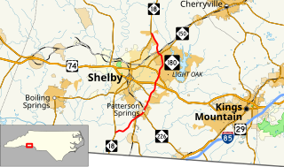
North Carolina Highway 180 (NC 180) is a primary state highway in the U.S. state of North Carolina. The highway serves as a bypass east of Shelby.

North Carolina Highway 72 highway in North Carolina

North Carolina Highway 72 (NC 72) is a primary state highway in the U.S. state of North Carolina that serves the communities of Red Springs and Lumberton. The east–west-signed highway physically runs more north and south through Robeson County.

North Carolina Highway 79 highway in North Carolina

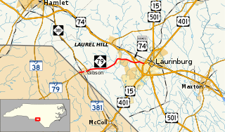
North Carolina Highway 79 (NC 79) is a primary state highway in the U.S. state of North Carolina running from the South Carolina border at Gibson to U.S. Routes US 15, US 401, and US 501 in Laurinburg.

North Carolina Highway 481

North Carolina Highway 481 (NC 481) is a 21-mile-long (34 km) primary state highway in the U.S. state of North Carolina. It serves to connect Enfield to nearby Interstate 95 (I-95) and the surrounding farmlands of southern Halifax County.

North Carolina Highway 742

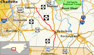
North Carolina Highway 742 (NC 742) is a primary state highway in the U.S. state of North Carolina. It connects the city of Wadesboro with the towns of Oakboro and Chesterfield, South Carolina.

North Carolina Highway 410

North Carolina Highway 410 (NC 410) is a primary state highway in the U.S. state of North Carolina. It serves as the central north–south highway in Columbus and Bladen Counties.

North Carolina Highway 710

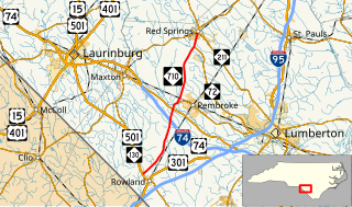
North Carolina Highway 710 (NC 710) is a primary state highway in the U.S. state of North Carolina. It connects the town of Pembroke to Interstate 74 (I-74) and U.S. Route 74 and the nearby towns of Red Springs and Rowland.

References

  1. 1 2 Google (January 8, 2012). "North Carolina Highway 274" (Map). Google Maps . Google. Retrieved January 8, 2012.
  2. State Highway System of North Carolina (PDF) (Map). Cartography by NCDOT. North Carolina Department of Transportation. 1930. Retrieved November 10, 2014.
  3. North Carolina Primary Highway System (PDF) (Map). Cartography by NCDOT. North Carolina Department of Transportation. 1940. Retrieved November 10, 2014.
KML file (edithelp)
    KML is from Wikidata