Dallas, North Carolina

Last updated

Dallas, North Carolina
NCMap-doton-Dallas.PNG
Location of Dallas, North Carolina
Coordinates: 35°19′02″N81°11′00″W / 35.31722°N 81.18333°W / 35.31722; -81.18333
Country United States
State North Carolina
County Gaston
Founded1846 [1]
Incorporated1863 [1]
Named for George M. Dallas [1]
Government
  MayorRick Coleman[ citation needed ]
Area
[2]
  Total3.06 sq mi (7.93 km2)
  Land3.06 sq mi (7.93 km2)
  Water0.00 sq mi (0.00 km2)
Elevation
[3]
787 ft (240 m)
Population
 (2020)
  Total5,927
  Density1,935.66/sq mi (747.39/km2)
Time zone UTC-5 (Eastern (EST))
  Summer (DST) UTC-4 (EDT)
ZIP code
28034
Area code(s) 704, 980
FIPS code 37-16180 [4]
GNIS feature ID2406350 [3]
Website www.dallasnc.net

Dallas is a town in Gaston County, North Carolina, United States, and a suburb of Charlotte, located north of Gastonia. The population was 4,488 at the 2010 census. [5] It was named for George M. Dallas, Vice President of the United States under James K. Polk.

Contents

Geography

Dallas is located approximately four miles north of the city of Gastonia and about 24 miles (39 km) west of Charlotte. Lincolnton is 13 miles (21 km) north and Hickory is 34 miles (55 km) north of Dallas along US 321.

According to the United States Census Bureau, the town has a total area of 2.9 square miles (7.5 km2), all of it land. [5]

Dallas lies within the Long Creek watershed. Long Creek is a right tributary of the South Fork Catawba River. Dallas is drained by Long Creek tributaries Dallas Branch and Little Long Creek. [6]

History

Dallas was officially incorporated in 1863 and is the oldest incorporated town in Gaston County. It served as the original county seat for Gaston County from 1846 until 1911. The old Gaston County courthouse, renovated in 1868 after a fire, still stands in the main square of the town and formerly served as the headquarters of the Dallas Police Department. [7] [8] The town government has renovated the courthouse. [9]

Dallas began to decline in importance when the town commissioners refused to appropriate money for construction of bridges over several creeks for the Atlanta and Richmond Air-Line Railway in the 1872. [10] The commissioners said the reason was because residents thought that trains would wake them during the night and frighten their livestock. [11] In 1890, White Caps attacked the town "'Kuklux' style", destroying entire portions of the town. [12] After this the county seat was relocated to Gastonia in 1911.

The Dallas Graded and High School, Dallas Historic District, Hoyle House, and Eli Hoyle House are listed on the National Register of Historic Places. [13]

Demographics

Historical population
CensusPop.Note
1870 299
1880 41739.5%
1890 4415.8%
1900 51416.6%
1910 1,065107.2%
1920 1,39731.2%
1930 1,4896.6%
1940 1,70414.4%
1950 2,45444.0%
1960 3,27033.3%
1970 4,05924.1%
1980 3,340−17.7%
1990 3,012−9.8%
2000 3,40212.9%
2010 4,48831.9%
2020 5,92732.1%
U.S. Decennial Census [14]

2020 census

Dallas racial composition [15]
RaceNumberPercentage
White (non-Hispanic)3,47558.63%
Black or African American (non-Hispanic)1,27721.55%
Native American 240.4%
Asian 510.86%
Pacific Islander 30.05%
Other/Mixed 2975.01%
Hispanic or Latino 80013.5%

As of the 2020 United States census, there were 5,927 people, 1,833 households, and 1,158 families residing in the town.

2010 census

As of the census [4] of 2010, there were 4,488 people, 1,792 households, and 1,195 families residing in the town. The population density was 1,543 inhabitants per square mile (596/km2). There were 2,003 housing units at an average density of 690.7 per square mile (266.7/km2). The racial makeup of the town was 76.4% White, 15.9% African American, 0.4% Native American, 0.6% Asian, 4.9% some other race, and 1.8% from two or more races. Hispanic or Latino of any race were 8.0% of the population. [16]

There were 1,792 households, out of which 37.3% had children under the age of 18 living with them, 40.7% were married couples living together, 19.9% had a female householder with no husband present, and 33.3% were non-families. 28.2% of all households were made up of individuals, and 10.2% had someone living alone who was 65 years of age or older. The average household size was 2.5 and the average family size was 3.04. [16]

In the town, the population was spread out, with 26.0% under the age of 18, 9.6% from 18 to 24, 30.2% from 25 to 44, 22.2% from 45 to 64, and 12.1% who were 65 years of age or older. The median age was 34.9 years. The male population was 47.7% and the female population was 52.3%. [16]

For the period 2007–11, the estimated median annual income for a household in the town was $35,625, and the median income for a family was $48,239. Male full-time workers had a median income of $32,203 versus $27,154 for females. The per capita income for the town was $18,570. About 11.1% of families and 14.6% of the population were below the poverty line, including 18.8% of those under age 18 and 6.5% of those age 65 or over. [17]

Education

Dallas is the site of the main campus of Gaston College, a community college offering associate degree, Certificate, and Diploma programs. It is located on U.S. Highway 321 west of the city's business district.

Dallas is home to Costner Elementary, Carr Elementary, W.C. Friday Middle School, and North Gaston High School.

The Dallas Branch of the Gaston County Public Library serves this community. [18]

Places of interest

Media

Television

Dallas is in the Charlotte-Gastonia viewing area. This is the list of the Television stations available in Dallas:

Radio

This is the list of the radio stations available in Dallas:

Notable residents and natives

Related Research Articles

<span class="mw-page-title-main">Lincoln County, North Carolina</span> County in North Carolina, United States

Lincoln County is a county located in the U.S. state of North Carolina. As of the 2020 census, the population was 86,810, making it the most populous "Lincoln County" in the United States. Its county seat is Lincolnton.

<span class="mw-page-title-main">Gaston County, North Carolina</span> County in North Carolina, United States

Gaston County is a county in the U.S. state of North Carolina. As of the 2020 census, the population was 227,943. The county seat is Gastonia. Dallas served as the original county seat from 1846 until 1911.

<span class="mw-page-title-main">Graham, North Carolina</span> City in North Carolina, United States

Graham is a city in Alamance County, North Carolina, United States. It is part of the Burlington, North Carolina Metropolitan Statistical Area. As of the 2020 census the population was 17,153. It is the county seat of Alamance County.

<span class="mw-page-title-main">Jefferson, North Carolina</span> Town in North Carolina, United States

Jefferson is a town in and the county seat of Ashe County, North Carolina, United States. The population was 1,622 at the 2020 U.S. census.

<span class="mw-page-title-main">Windsor, North Carolina</span> Town in North Carolina, United States

Windsor is a town in Bertie County, North Carolina, United States. The population was 3,630 at the 2010 census, up from 2,283 in 2000. It is the county seat of Bertie County, which is also the homeland of the Southern Band Tuscarora Tribe that remained in North Carolina post Colonialism. Windsor is located in North Carolina's Inner Banks region.

<span class="mw-page-title-main">Belmont, North Carolina</span> City in North Carolina, United States

Belmont is a small suburban city in Gaston County, North Carolina, United States, located about 9 miles (14 km) east of Gastonia. The population was 10,076 at the 2010 census. Once known as Garibaldi Station, it was named for the New York banker August Belmont. Belmont is home to Belmont Abbey College.

<span class="mw-page-title-main">Cherryville, North Carolina</span> City in North Carolina, United States

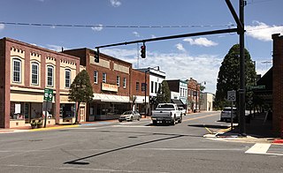
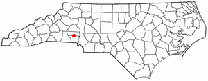
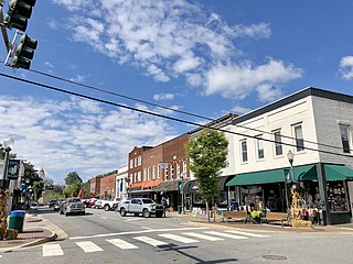
Cherryville is a city in northwestern Gaston County, North Carolina, United States. The population was 5,760 at the 2010 census. The New Year's Shooters celebrate the area's German heritage by beginning each year with a customary chant and the honorary shooting of muskets. Cherryville is located approximately 38 miles (61 km) west of Charlotte and 16 miles (26 km) northwest of Gastonia.

<span class="mw-page-title-main">Cramerton, North Carolina</span> Town in North Carolina, United States

Cramerton is a small town in Gaston County, North Carolina, United States. It is a suburb of Charlotte and located east of Gastonia. The population was 4,165 at the 2010 census. A well-known feature is the Cramer Mountain gated development, featuring homes around an 18-hole golf course at Cramer Mountain Country Club.

<span class="mw-page-title-main">Gastonia, North Carolina</span> City in North Carolina, United States

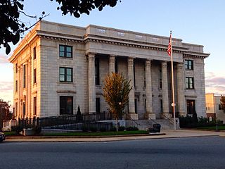
Gastonia is the most populous city in and county seat of Gaston County, North Carolina, United States. It is the second-largest satellite city of the Charlotte area, behind Concord. The population was 80,411 in the 2020 census, up from 71,741 in 2010. Gastonia is the 13th-most populous city in North Carolina. It is part of the Charlotte-Concord-Gastonia, NC-SC Metropolitan Statistical Area, which is part of the Charlotte-Concord, NC-SC Combined Statistical Area.

<span class="mw-page-title-main">High Shoals, North Carolina</span> City in North Carolina, United States

High Shoals is a city in Gaston County, North Carolina, United States, named for the high rocky shoal across the Catawba River. The population was 696 at the 2010 census.

<span class="mw-page-title-main">Lowell, North Carolina</span> City in North Carolina, United States

Lowell is a small city in Gaston County, North Carolina, United States, located east of Gastonia. The population was 3,526 at the 2010 census.

<span class="mw-page-title-main">McAdenville, North Carolina</span> Town in North Carolina, United States

McAdenville is a small town in Gaston County, North Carolina, United States. It is a suburb of Gastonia and located east of Gastonia. The population was 890 at the 2020 census.

<span class="mw-page-title-main">Mount Holly, North Carolina</span> City in North Carolina, United States

Mount Holly is a small suburban city in northeastern Gaston County, North Carolina, United States. The city is situated just west of the Catawba River, north of Interstate 85, south of North Carolina State Highway 16. The population was 17,703 at the 2020 census, up from 13,656 in 2010.

<span class="mw-page-title-main">Snow Hill, North Carolina</span> Town in North Carolina, United States

Snow Hill is a town in Greene County, North Carolina, United States. The population was 1,595 at the 2010 census. It is the county seat of Greene County and is part of the Greenville Metropolitan Area. Snow Hill hosts numerous tennis tournaments during the year. Snow Hill is home to the Green Ridge Racquet Club. Many junior players and adults travel to Snow Hill in order to play in the USTA Sanctioned tournaments.

<span class="mw-page-title-main">Sylva, North Carolina</span> Town in North Carolina, United States

Sylva is an incorporated town located in central Jackson County, in the Plott Balsam Mountains of Western North Carolina, United States. As of the 2010 census, the town had a total population of 2,588. It is the county seat, taking over the role from nearby Webster in 1913.

<span class="mw-page-title-main">Webster, North Carolina</span> Town in North Carolina, United States

Webster is a town in Jackson County, North Carolina, United States. As of the 2010 census, the population was 363, down from 486 in 2000.

<span class="mw-page-title-main">Clover, South Carolina</span> Town in South Carolina, United States

Clover is a town in York County, South Carolina, United States. It is located in the greater Charlotte metropolitan area. As of 2020, the population was at 6,671 within the town limits. Clover is twinned with the Northern Irish town of Larne on County Antrim's East Coast.

<span class="mw-page-title-main">Ridgeway, Virginia</span> Town in Virginia, United States

Ridgeway is a town in Henry County, Virginia, United States. The population was 742 at the 2010 census. It is part of the Martinsville Micropolitan Statistical Area. Martinsville Speedway, a NASCAR racetrack, is located between Ridgeway and the Martinsville city limits.

<span class="mw-page-title-main">Kings Mountain, North Carolina</span> City in North Carolina, United States

Kings Mountain is a small suburban city within the Charlotte metropolitan area in Cleveland and Gaston counties, North Carolina, United States. Most of the city is in Cleveland County, with a small eastern portion in Gaston County. The population was 10,296 at the 2010 census.

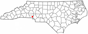
Cherryville Township is a township in northwestern Gaston County, North Carolina, United States. As of the 2010 census it had a population of 16,500. It includes the incorporated city of Cherryville, the inactive incorporated town of Dellview, the unincorporated community of Tryon, and a portion of the town of High Shoals. It is represented on the Gaston County Board of Commissioners by Allen Fraley of Cherryville.

References

  1. 1 2 3 "North Carolina Gazetteer" . Retrieved December 19, 2022.
  2. "ArcGIS REST Services Directory". United States Census Bureau. Retrieved September 20, 2022.
  3. 1 2 U.S. Geological Survey Geographic Names Information System: Dallas, North Carolina
  4. 1 2 "U.S. Census website". United States Census Bureau . Retrieved January 31, 2008.
  5. 1 2 "Geographic Identifiers: 2010 Demographic Profile Data (G001): Dallas town, North Carolina". U.S. Census Bureau, American Factfinder. Archived from the original on February 12, 2020. Retrieved March 27, 2013.
  6. Gaston County Watershed Map Archived September 11, 2008, at the Wayback Machine
  7. "Gaston County official government website. Retrieved on 2011-10-25". Archived from the original on March 31, 2012. Retrieved October 25, 2011.
  8. "Dallas Police Department official web page. Retrieved on 2011-10-25". Archived from the original on April 4, 2012. Retrieved October 25, 2011.
  9. ""Historic courthouse to find new uses," Gaston Gazette, October 4, 2011. Retrieved on 2011-10-25". Archived from the original on November 7, 2011. Retrieved October 25, 2011.
  10. Brief History, Town of Dallas official government website. Retrieved on July 10, 2008.
  11. Link, William A. William Friday: Power, Purpose, and American Higher Education. Chapel Hill, N.C. University of North Carolina Press, 1995. ISBN   978-0-8078-2167-1
  12. https://chroniclingamerica.loc.gov/lccn/sn84024546/1890-09-06/ed-1/seq-1.pdf [ bare URL PDF ]
  13. "National Register Information System". National Register of Historic Places . National Park Service. July 9, 2010.
  14. "Census of Population and Housing". Census.gov. Retrieved June 4, 2015.
  15. "Explore Census Data". data.census.gov. Retrieved December 20, 2021.
  16. 1 2 3 "Profile of General Population and Housing Characteristics: 2010 Demographic Profile Data (DP-1): Dallas town, North Carolina". U.S. Census Bureau, American Factfinder. Archived from the original on February 12, 2020. Retrieved March 27, 2013.
  17. "Selected Economic Characteristics: 2007-2011 American Community Survey 5-Year Estimates (DP03): Dallas town, North Carolina". U.S. Census Bureau, American Factfinder. Archived from the original on February 10, 2020. Retrieved March 27, 2013.
  18. Dallas Branch
  19. National Register of Historic Places - Gaston County
  20. "Designated Gaston County Historic Properties". Archived from the original on December 25, 2008. Retrieved July 10, 2008.