North Carolina Highway 279

Last updated

NC 279.svg

North Carolina Highway 279
NC 279 map.svg
Route information
Maintained by NCDOT
Length28.6 mi [1] (46.0 km)
Existed1979–present
Major junctions
West endNC 150.svg NC 150 in Cherryville
 US 321.svg US 321 in Dallas
I-85.svg I-85 in Gastonia
US 29.svgUS 74.svg US 29 / US 74 in Gastonia
East endPole Branch Road at the South Carolina line near Lake Wylie, SC
Location
Counties Gaston
Highway system
I-277.svg I-277 NC 280 NC 280.svg

North Carolina Highway 279 (NC 279) is a primary state highway in the U.S. state of North Carolina. It connects the cities of Cherryville, Dallas, and Gastonia.

A state highway, state road, or state route is usually a road that is either numbered or maintained by a sub-national state or province. A road numbered by a state or province falls below numbered national highways in the hierarchy. Roads maintained by a state or province include both nationally numbered highways and un-numbered state highways. Depending on the state, "state highway" may be used for one meaning and "state road" or "state route" for the other.

North Carolina State of the United States of America

North Carolina is a state in the southeastern region of the United States. It borders South Carolina and Georgia to the south, Tennessee to the west, Virginia to the north, and the Atlantic Ocean to the east. North Carolina is the 28th-most extensive and the 9th-most populous of the U.S. states. The state is divided into 100 counties. The capital is Raleigh, which along with Durham and Chapel Hill is home to the largest research park in the United States. The most populous municipality is Charlotte, which is the second-largest banking center in the United States after New York City.

Cherryville, North Carolina City in North Carolina, United States

Cherryville is a small city in northwestern Gaston County, North Carolina, United States. The population was 5,760 at the 2010 census. The New Year's Shooters celebrate the area's German heritage by beginning each year with a customary chant and the honorary shooting of muskets. Cherryville is located approximately 40 miles (64 km) west of Charlotte and 13 miles (21 km) northwest of Gastonia.

Contents

Route description

Directional signs of NC 150 and NC 279, in Cherryville NC150-NC279-Cherryville.jpg
Directional signs of NC 150 and NC 279, in Cherryville

History

Established in January 1979 as a renumbering of NC 277, it originally traversed from Cherryville to NC 275, in Dallas. In November 1979, NC 279 was extended southeast to the South Carolina state line; overlapping with NC 150 through Dallas and upgrading secondary roads Lower Dallas Highway (SR 2264) and New Hope Road (SR 2302). At some unknown date, NC 279's western terminus was redirected from the intersection of Church and Mountain streets to Church Street and Rudsil Avenue, in Cherryville. [2] [3]

North Carolina Highway 275 highway in North Carolina

North Carolina Highway 275 (NC 275) is a primary state highway in the U.S. state of North Carolina. It connects the cities of Bessemer City, Dallas, and Stanley.

South Carolina State of the United States of America

South Carolina is a state in the Southeastern United States and the easternmost of the Deep South. It is bordered to the north by North Carolina, to the southeast by the Atlantic Ocean, and to the southwest by Georgia across the Savannah River.

Concurrency (road) instance of one physical road bearing two or more different highways

A concurrency in a road network is an instance of one physical roadway bearing two or more different route numbers. When two roadways share the same right-of-way, it is sometimes called a common section or commons. Other terminology for a concurrency includes overlap, coincidence, duplex, triplex, multiplex, dual routing or triple routing.

North Carolina Highway 277

NC 277.svg

North Carolina Highway 277
Location Cherryville-Dallas, NC
Length12.5 mi [4] (20.1 km)
Existed1931–1979

North Carolina Highway 277 (NC 277) was established in 1931 as a new primary routing; it connected U.S. Route 74 (US 74)/NC 20, in Gastonia to NC 150 in Cherryville. In 1936, its southern terminus was truncated at NC 275 in Dallas. In 1938, its western terminus was moved through downtown Cherryville to NC 274; it is unknown when it was overlapped with NC 274 to end at Church and Mountain streets. Between 1954 and 1957, the alignment along the route was straightened, creating several small loop roads along the route, several of which say "Old NC 277". In 1979, NC 277 was renumbered to NC 279, to accommodate for Interstate 277. [2]

U.S. Route 74 (US 74) is an east–west United States highway that runs for 515 miles (829 km) from Chattanooga, Tennessee to Wrightsville Beach, North Carolina. Predominantly in North Carolina, it serves as an important highway from the mountains to the sea, connecting the cities of Asheville, Charlotte and Wilmington.

North Carolina Highway 20 highway in North Carolina

North Carolina Highway 20 is a 27-mile (43 km) North Carolina state highway that runs through Hoke, Robeson and Bladen counties. It serves as a major road in each of the three incorporated communities through which it passes. The route is co-designated as St. Pauls Road in Raeford, Main Street in Lumber Bridge, and Broad Street in St. Pauls.

North Carolina Highway 274 highway in North Carolina

North Carolina Highway 274 (NC 274) is a primary state highway in the U.S. state of North Carolina. It connects rural areas of Lincoln and Gaston counties to Gastonia.

Junction list

The entire route is in Gaston County.

Locationmi [1] kmDestinationsNotes
Cherryville 0.00.0NC 150.svg NC 150 (Church Street)
2.94.7Saint Marks Church Road – Crouse Interchange
Dallas 11.318.2NC 275.svg NC 275 west (Dallas-Bessemer City Highway) Bessemer City West end of NC 275 overlap
11.919.2No image.svgBusiness plate.svgNo image.svg
US 321.svg US 321 Bus. north (Dallas-High Shoals Highway)
West end of US 321 Business overlap
12.019.3No image wide.svgNo image.svgBusiness plate.svgNo image.svg
US 321.svgUS 321.svg US 321 / US 321 Bus. ends Gastonia, Hickory
Interchange; east end of US 321 Business overlap
513.1825.8NC 275.svg NC 275 east (Dallas-Stanley Highway) Stanley, Mount Holly East end of NC 275 overlap
Gastonia 16.326.2NC 7.svg NC 7 (Ozark Avenue)
17.127.5I-85.svg I-85  Spartanburg, Charlotte Exit 20 (I-85)
17.628.3US 29.svgUS 74.svgAirport Sign.svg US 29 / US 74 (Franklin Boulevard) Belmont, Gastonia Municipal Airport
27.644.4NC 273.svg NC 273 north (Armstrong Road) Belmont Southern terminus of NC 273
28.646.0Pole Branch Road Lake Wylie South Carolina state line
1.000 mi = 1.609 km; 1.000 km = 0.621 mi

Related Research Articles

U.S. Route 321 highway in the United States

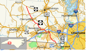
U.S. Route 321 (US 321) is a spur of U.S. Route 21. It runs for 516.9 miles (831.9 km) from Hardeeville, South Carolina to Lenoir City, Tennessee; with both serving as southern termini. It reaches its northernmost point at Elizabethton, Tennessee. Because of its unusual "north–south–north" routing, U.S. Route 321 intersects both Interstate 40 and U.S. Route 70 three separate times. The highway serves different roles in each state: An alternate route to interstates in South Carolina, a major highway in North Carolina, and a scenic route in Tennessee.

North Carolina Highway 740 highway in North Carolina

North Carolina Highway 740 is a primary state highway in the U.S. state of North Carolina. The main purpose of highway is to connect the town of Badin with the rest of Stanly County.

North Carolina Highway 7 highway in North Carolina

North Carolina Highway 7 (NC 7) is a primary state highway in the U.S. state of North Carolina. Entirely within Gaston County, it connects the towns of Lowell, McAdenville, and Belmont with the city of Gastonia.

North Carolina Highway 16 highway in North Carolina

North Carolina Highway 16 (NC 16) is a primary state highway in the U.S. state of North Carolina. Traveling north–south, it connects the cities of Charlotte, Conover, Taylorsville, Wilkesboro and Jefferson; linking the Charlotte metropolitan area with the High Country.

North Carolina Highway 50 highway in North Carolina

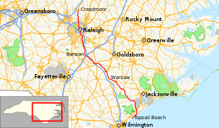
North Carolina Highway 50 (NC 50) is a primary state highway in the U.S. state of North Carolina. It traverses north–south, from Topsail Beach to Creedmoor, connecting the cities of Warsaw, Newton Grove, Benson, and Raleigh.

North Carolina Highway 49 highway in North Carolina

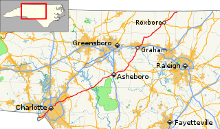
North Carolina Highway 49 (NC 49) is a primary state highway in the U.S. state of North Carolina. It traverses much of the Piedmont region of North Carolina.

North Carolina Highway 90 highway in North Carolina

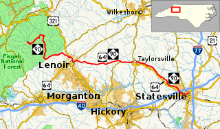
North Carolina Highway 90 is a primary state highway in the U.S. state of North Carolina. It is one of the few highways in the state with an unpaved portion.

North Carolina Highway 97 highway in North Carolina

North Carolina Highway 97 (NC 97) is a primary state highway in the U.S. state of North Carolina, connecting the cities of Zebulon and Rocky Mount with the vast rural coastal plains.

North Carolina Highway 28 highway in North Carolina

North Carolina Highway 28 (NC 28) is an 81.2-mile-long (130.7 km) primary state highway in the U.S. state of North Carolina. The highway runs north–south through the Nantahala National Forest in Western North Carolina.

North Carolina Highway 186 highway in North Carolina

North Carolina Highway 186 (NC 186) is a primary state highway in the U.S. state of North Carolina. Entirely in Northampton County, it helps facilitate truck traffic parallel to I-95 and connect the communities of Seaboard and Margarettsville.

North Carolina Highway 62 highway in North Carolina

North Carolina Highway 62 (NC 62) is a primary state highway in the U.S. state of North Carolina. Primarily in the Piedmont Triad, it runs from NC 109 in Thomasville northeast to the Virginia state line in Milton.

North Carolina Highway 200 highway in North Carolina

North Carolina Highway 200 (NC 200) is a primary state highway in the U.S. state of North Carolina. The highway runs north–south from the South Carolina state line near the community of JAARS, to US 601 near Concord.

North Carolina Highway 109 highway in North Carolina

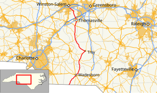
North Carolina Highway 109 (NC 109) is a north–south state highway in North Carolina. It primarily connects small towns in the central Piedmont region of the state. The 117-mile (188 km) route is a two-lane road for most of its length, but the segment between Winston-Salem and Thomasville is being upgraded to a divided 4-lane highway. The central segment of NC 109 passes through the Uwharrie Mountains and the Uwharrie National Forest.

North Carolina Highway 268 highway in North Carolina

North Carolina Highway 268 (NC 268) is a primary state highway in the U.S. state of North Carolina. It connects many communities as it traverses through the northwestern North Carolina mountains and foothills.

U.S. Route 29 in North Carolina highway in North Carolina

U.S. Route 29 is a north–south United States highway that runs for 168 miles (270 km) from the South Carolina state line, near Blacksburg, to the commonwealth of Virginia, near Danville. The route serves the North Carolina Piedmont, including the cities of Charlotte, Salisbury, High Point, and Greensboro.

North Carolina Highway 294 highway in North Carolina

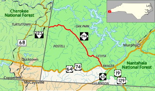
North Carolina Highway 294 (NC 294) is a primary state highway in the U.S. state of North Carolina. The highway serves to connect communities along the southern banks of the Hiwassee River.

North Carolina Highway 93 highway in North Carolina

North Carolina Highway 93 (NC 93) is a primary state highway in the U.S. state of North Carolina. It runs from the Virginia state line to the community of Twin Oaks, entirely in Alleghany County.

North Carolina Highway 152

North Carolina Highway 152 (NC 152) is a 25.5-mile-long (41.0 km) primary state highway in the U.S. state of North Carolina. It serves as the main thoroughfare in southern Rowan County.

References

  1. 1 2 Google (January 8, 2012). "North Carolina Highway 279" (Map). Google Maps . Google. Retrieved January 8, 2012.
  2. 1 2 "NC Route Change (1979-01-01)" (PDF). North Carolina Department of Transportation. January 1, 1979. Retrieved December 21, 2013.
  3. "NC Route Change (1979-11-01)" (PDF). North Carolina Department of Transportation. November 1, 1979. Retrieved December 21, 2013.
  4. Google (December 21, 2013). "North Carolina Highway 277" (Map). Google Maps . Google. Retrieved December 21, 2013.
KML file (edithelp)
    KML is from Wikidata