Oakwood, Cuyahoga County, Ohio

Last updated

Oakwood, Ohio
Alonzo Drake House.jpg
Alonzo Drake House on Broadway
Cuyahoga County Ohio incorporated and unincorporated areas Oakwood highlighted.svg
Cuyahoga County and the state of Ohio.
Coordinates: 41°22′1″N81°30′14″W / 41.36694°N 81.50389°W / 41.36694; -81.50389
CountryUnited States
State Ohio
County Cuyahoga
Government
  MayorGary V. Gottschalk
Area
[1]
  Total3.46 sq mi (8.95 km2)
  Land3.45 sq mi (8.93 km2)
  Water0.01 sq mi (0.02 km2)
Elevation
[2]
1,047 ft (319 m)
Population
 (2020)
  Total3,572
  Density1,035.66/sq mi (399.87/km2)
Time zone UTC-5 (Eastern (EST))
  Summer (DST) UTC-4 (EDT)
FIPS code 39-57750 [3]
GNIS feature ID1084030 [2]
Website www.oakwoodvillageoh.com

Oakwood is a village in Cuyahoga County, Ohio, United States. The population was 3,572 at the 2020 census. An inner ring suburb of Cleveland, it is a part of the Cleveland metropolitan area.

Contents

Geography

Oakwood is located at 41°22′01″N81°30′14″W / 41.367054°N 81.503783°W / 41.367054; -81.503783 . [4] According to the United States Census Bureau, the village has a total area of 3.45 square miles (8.94 km2), of which 3.44 square miles (8.91 km2) is land and 0.01 square miles (0.03 km2) is water. [5]

Demographics

Historical population
CensusPop.Note
1960 3,283
1970 3,4996.6%
1980 3,7868.2%
1990 3,392−10.4%
2000 3,6628.0%
2010 3,6670.1%
2020 3,572−2.6%
U.S. Decennial Census [6]

2010 census

As of the census [7] of 2010, there were 3,667 people, 1,544 households, and 935 families living in the village. The population density was 1,066.0 inhabitants per square mile (411.6/km2). There were 1,648 housing units at an average density of 479.1 per square mile (185.0/km2). The racial makeup of the village was 30.7% White, 64.7% African American, 0.2% Native American, 0.7% Asian, 0.1% Pacific Islander, 0.2% from other races, and 3.4% from two or more races. Hispanic or Latino of any race were 2.3% of the population.

There were 1,544 households, of which 24.6% had children under the age of 18 living with them, 38.3% were married couples living together, 17.2% had a female householder with no husband present, 5.1% had a male householder with no wife present, and 39.4% were non-families. 35.0% of all households were made up of individuals, and 12.3% had someone living alone who was 65 years of age or older. The average household size was 2.28 and the average family size was 2.94.

The median age in the village was 46.7 years. 18.7% of residents were under the age of 18; 7.7% were between the ages of 18 and 24; 21.5% were from 25 to 44; 32.9% were from 45 to 64; and 19.3% were 65 years of age or older. The gender makeup of the village was 47.6% male and 52.4% female.

2000 census

As of the census [3] of 2000, there were 3,667 people, 1,416 households, and 877 families living in the village. The population density was 1,060.1 inhabitants per square mile (409.3/km2). There were 1,480 housing units at an average density of 427.9 per square mile (165.2/km2). The racial makeup of the village was 40.66% White, 56.23% African American, 0.19% Native American, 0.35% Asian, 0.03% Pacific Islander, 0.71% from other races, and 1.83% from two or more races. Hispanic or Latino of any race were 1.39% of the population.

There were 1,416 households, out of which 23.2% had children under the age of 18 living with them, 44.1% were married couples living together, 13.3% had a female householder with no husband present, and 38.0% were non-families. 33.6% of all households were made up of individuals, and 14.3% had someone living alone who was 65 years of age or older. The average household size was 2.43 and the average family size was 3.13.

In the village, the population was spread out, with 21.5% under the age of 18, 7.4% from 18 to 24, 23.5% from 25 to 44, 26.8% from 45 to 64, and 20.8% who were 65 years of age or older. The median age was 44 years. For every 100 females there were 87.8 males. For every 100 females age 18 and over, there were 86.0 males.

The median income for a household in the village was $39,404, and the median income for a family was $54,375. Males had a median income of $35,806 versus $30,735 for females. The per capita income for the village was $19,408. About 2.9% of families and 6.3% of the population were below the poverty line, including 3.0% of those under age 18 and 17.0% of those age 65 or over.

Government

Oakwood was incorporated in 1951. In 1968 it enacted a home rule charter. The village is governed by a mayor-council form of government, with full-time services. Public safety services are provided by a full-time police department and a part-time fire department. The village also conducts its own mayor's court. [8]

Notable person

See also

Related Research Articles

<span class="mw-page-title-main">Nokomis, Florida</span> Census-designated place in Florida, United States

Nokomis is an unincorporated town in Sarasota County and a census-designated place (CDP) along the Gulf Coast of Florida, United States, located south of Osprey and just north of Venice. The town has access to the coast through Nokomis Public Beach and Casey Key. The town's population was 3,167 at the 2010 census. It is part of the Bradenton–Sarasota–Venice Metropolitan Statistical Area.

<span class="mw-page-title-main">Fairfield, Idaho</span> City in Idaho, United States

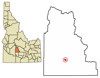
Fairfield is the county seat of and the only village in Camas County, Idaho. The population was 410 at the time of 2010 census, nearly half of the rural county's population.

<span class="mw-page-title-main">Oakwood Hills, Illinois</span> Village in Illinois, United States

Oakwood Hills is a village in McHenry County, Illinois, United States. It was founded in 1959. The population was 2,076 at the 2020 census.

<span class="mw-page-title-main">Melvindale, Michigan</span> City in Michigan, United States

Melvindale is a city in Wayne County of the U.S. state of Michigan. At the 2020 census, the city population was 12,851.

<span class="mw-page-title-main">Oaks, Missouri</span> Village in Missouri, United States

Oaks is a village in Clay County, Missouri, United States. The population was 128 at the 2020 census. It is part of the Kansas City metropolitan area.

<span class="mw-page-title-main">Oakwood, Missouri</span> Village in Missouri, United States

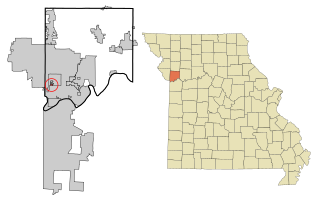
Oakwood is a village in Clay County, Missouri, United States. The population was 198 at the 2020 census. It is part of the Kansas City metropolitan area.

<span class="mw-page-title-main">Oakwood Park, Missouri</span> Village in Missouri, United States

Oakwood Park is a village in Clay County, Missouri, United States. The population was 189 at the 2020 census. It is part of the Kansas City metropolitan area.

<span class="mw-page-title-main">Whittingham, New Jersey</span> Populated place in Middlesex County, New Jersey, US

Whittingham, also known as Greenbriar at Whittingham, is an unincorporated community and census-designated place (CDP) located within Monroe Township, in Middlesex County, in the U.S. state of New Jersey. As of the 2010 United States Census, the CDP's population was 2,476. The area is focused around the age-restricted gated community of Whittingham.

<span class="mw-page-title-main">Holloway, Ohio</span> Village in Ohio, United States

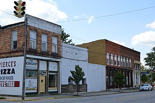
Holloway is a village in Belmont County, Ohio, United States. The population was 330 at the 2020 census. It is part of the Wheeling metropolitan area. Holloway was laid out in 1883, and named after the local Holloway family.

<span class="mw-page-title-main">Prospect, Ohio</span> Village in Ohio, United States

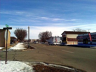
Prospect is a village in Marion County, Ohio, United States. The population was 1,067 at the 2020 census. The village is served by Elgin Local School District.

<span class="mw-page-title-main">Oakwood, Paulding County, Ohio</span> Village in Ohio, United States

Oakwood is a village in Paulding County, Ohio, United States. The population was 546 at the 2020 census.

<span class="mw-page-title-main">Oakwood, Oklahoma</span> Town in Oklahoma, United States

Oakwood is a town in Dewey County, Oklahoma, United States. The population was 65 at the 2010 census.

<span class="mw-page-title-main">The Village, Oklahoma</span> City in Oklahoma, United States

The Village is a city in Oklahoma County, Oklahoma, United States, and a part of the Oklahoma City metropolitan area. The population was 9,538 at the 2020 Census.

<span class="mw-page-title-main">Lower Heidelberg Township, Pennsylvania</span> Township in Pennsylvania, United States

Lower Heidelberg Township is a township in Berks County, Pennsylvania, United States. The population was 5,513 at the 2010 census.

<span class="mw-page-title-main">Richmond Township, Berks County, Pennsylvania</span> Township in Pennsylvania, United States

Richmond Township is a township in Berks County, Pennsylvania, United States. The population was 3,397 at the 2010 census.

<span class="mw-page-title-main">Wilmington Township, Mercer County, Pennsylvania</span> Township in Pennsylvania, United States

Wilmington Township is a township in Mercer County, Pennsylvania, United States. The population was 1,416 at the 2020 census, an increase from 1,415 in 2010.

<span class="mw-page-title-main">Butler Township, Schuylkill County, Pennsylvania</span> Township in Pennsylvania, United States

Butler Township is a township in Schuylkill County, Pennsylvania, United States. Formed in 1848 from part of Barry Township, it is named for war hero William Orlando Butler.

Wedgefield is a census-designated place (CDP) in Sumter County, South Carolina, United States. The population was 1,544 at the 2000 census.

<span class="mw-page-title-main">Oostburg, Wisconsin</span> Village in Wisconsin, United States

Oostburg is a village in Sheboygan County, Wisconsin, United States. The population was 2,887 at the 2010 census. It is included in the Sheboygan, Wisconsin Metropolitan Statistical Area.

<span class="mw-page-title-main">Wilson, Ohio</span> Village in Ohio, United States

Wilson is a village in Belmont and Monroe counties in the U.S. state of Ohio. The population was 129 at the 2020 census. It is part of the Wheeling metropolitan area.

References

  1. "ArcGIS REST Services Directory". United States Census Bureau. Retrieved September 20, 2022.
  2. 1 2 "US Board on Geographic Names". United States Geological Survey. October 25, 2007. Retrieved January 31, 2008.
  3. 1 2 "U.S. Census website". United States Census Bureau . Retrieved January 31, 2008.
  4. "US Gazetteer files: 2010, 2000, and 1990". United States Census Bureau. February 12, 2011. Retrieved April 23, 2011.
  5. "US Gazetteer files 2010". United States Census Bureau. Archived from the original on January 12, 2012. Retrieved January 6, 2013.
  6. "Census of Population and Housing". Census.gov. Retrieved June 4, 2015.
  7. "U.S. Census website". United States Census Bureau . Retrieved January 6, 2013.
  8. "Mayor's Court". The Village of Oakwood.