
Virginia Beach is an independent city located on the southeastern coast of Virginia, United States. The population was 459,470 at the 2020 census. Although mostly suburban in character, it is the most populous city in Virginia, fifth-most populous city in the Mid-Atlantic, ninth-most populous city in the Southeast and the 42nd-most populous city in the U.S. Located on the Atlantic Ocean at the mouth of the Chesapeake Bay, Virginia Beach is the largest city in the Hampton Roads metropolitan area which includes 6 other cities. This area, sometimes referred to as "America's First Region", also includes the independent cities of Chesapeake, Hampton, Newport News, Norfolk, Portsmouth, and Suffolk, as well as other smaller cities, counties, and towns of Hampton Roads.

Oceana County is a county located in the U.S. state of Michigan. As of the 2020 Census, the population was 26,659. The county seat is Hart. Long known as part of the large Ojibwe territory, the county was founded by European Americans in 1840 and organized in 1855.

Oceana is a town in Wyoming County, West Virginia. The population was 1,462 at the time of the 2020 census. Oceana is the oldest city in Wyoming County and was the county seat until 1907.

South Hampton Roads is a region located in the extreme southeastern portion of Virginia's Tidewater region in the United States with a total population of 1,191,937. It is part of the Virginia Beach-Norfolk-Newport News, VA-NC MSA, which itself has a population of 1,724,876.
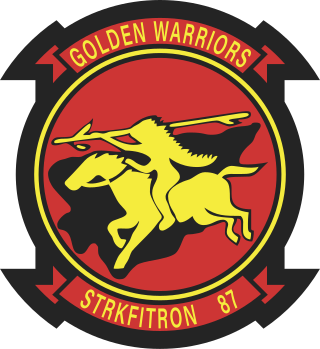
The Strike Fighter Squadron 87 (VFA-87) is a United States Navy strike fighter squadron based at Naval Air Station Oceana. The squadron is equipped with the Boeing F/A-18E Super Hornet and is nicknamed the Golden Warriors, its call sign is War Party. Currently, the squadron is assigned to Carrier Air Wing 8.

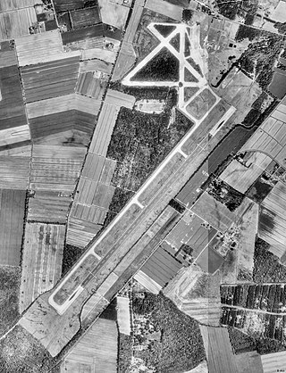
Naval Air Station (NAS) Oceana or NAS Oceana is a United States Navy Naval Air Station located in Virginia Beach, Virginia.

West Virginia Route 971 is a 9.9-mile (15.9 km) north–south state highway in Wyoming County, West Virginia. The route runs from West Virginia Route 97 in Baileysville north to West Virginia Route 10 in Oceana. It runs through mountainous, rural terrain, connecting Baileysville and Oceana to the communities of Clear Fork, Lillydale, and Lillyhaven. WV 971 has been the highest numbered state highway in West Virginia since July 2017, when WV 972 was decommissioned and absorbed by WV 93.

Strike Fighter Squadron 106 (VFA-106), also known as the "Gladiators", is a United States Navy F/A-18 Hornet and F/A-18E/F Super Hornet Fleet Replacement Squadron stationed at Naval Air Station Oceana, Virginia.
Virginia Beach City Public Schools is the branch of the government of the city of Virginia Beach, Virginia responsible for public K-12 education. Like all public school systems in the state, it is legally classified as a school division instead of a school district. Although Virginia school divisions perform the functions of school districts in other U.S. states, they have no taxing authority, instead relying on appropriations from their local governments.
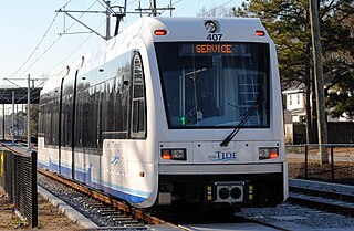
The Tide is a 7.4 mi (12 km) light rail line in Norfolk, Virginia, United States, owned and operated by Hampton Roads Transit (HRT). It connects Eastern Virginia Medical School, downtown Norfolk, Norfolk State University, and Newtown Road. Service began on August 19, 2011, making it the first light rail system in Virginia. Fares match local bus fares and the line accepts HRT's GO Passes. Trains generally run every 15 minutes, increasing to every 10 minutes during peak periods and every 30 minutes during early mornings and late evenings. In 2022, the system had a ridership of 732,700, or about 2,000 per weekday as of the first quarter of 2023.
Lynnhaven is one of the seven original boroughs created when the city of Virginia Beach, Virginia was formed in 1963. It is located in the North Central portion of the city.
Virginia Beach, Virginia is a city that has become a popular tourist destination in recent years on account of its historical, scientific, and performing arts.
Naval Auxiliary Landing Field Fentress is a military use airport located in Chesapeake, Virginia. This military airport is owned by the U.S. Navy and is under the operational control of Naval Air Station Oceana, Virginia. The airfield primarily supports day and night Field Carrier Landing Practice (FCLP) operations by US Navy and US Marine Corps F/A-18 Hornet, and US Navy F/A-18 Super Hornet, E-2 Hawkeye and C-2 Greyhound aircraft based in Virginia and the Carolinas.
Uno is an unincorporated community in Wyoming County, West Virginia, United States. Uno is 7.5 miles (12.1 km) west-southwest of Oceana.
Lacoma is an unincorporated community in Wyoming County, West Virginia, United States. Lacoma is located along Huff Creek and West Virginia Route 10, 4.7 miles (7.6 km) northwest of Oceana.
In the United States Navy, a master jet base is a naval air station with permanent basing and homeporting of carrier-based tactical jet squadrons, carrier air wings, and the provision of one or more jet-capable naval outlying fields or auxiliary landing fields in relatively close proximity for use in concentrated Field Carrier Landing Practice (FCLP).
Toney Fork is an unincorporated community in Wyoming County, West Virginia, United States. Toney Fork is located on West Virginia Route 85 at the confluence of the Clear Fork and the Toney Fork, 2 miles (3.2 km) northeast of Oceana.

The Oceana Neighborhood Historic District encompasses an early 20th-century planned neighborhood subdivision in Virginia Beach, Virginia. It consists of 70 acres (28 ha), roughly bounded by Virginia Beach Boulevard, First Colonial Road, and North Oceana Boulevard. This area was platted out in 1906 with a rectilinear street grid, and saw development of its commercial corridors in the 1930s. It contains a diversity of period residential architecture, including many examples of Colonial Revival architecture, as well as a number of older houses that predate the subdivision.

