Princess Anne, Virginia

Last updated
Princess Anne
Building10VirginiaBeachMunicipalCenter.jpg
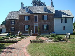
Building 10, a courthouse, Virginia Beach Municipal Center
USA Virginia location map.svg
Red pog.svg
Princess Anne
Location within the state of Virginia
Usa edcp location map.svg
Red pog.svg
Princess Anne
Princess Anne (the United States)
Coordinates: 36°45′6″N76°3′11″W / 36.75167°N 76.05306°W / 36.75167; -76.05306
CountryUnited States
State Virginia
Independent city Virginia Beach
Princess Anne Shire 1691
Time zone UTC−5 (Eastern (EST))
  Summer (DST) UTC−4 (EDT)
ZIP codes
23453 23454 23456 23457
Area code(s) 757, 948

Princess Anne is a community located in the independent city of Virginia Beach, Virginia, United States at the junction of Princess Anne Road and North Landing Road near the West Neck River. The community, which dates from 1691, was named after Princess Anne of Denmark and Norway (later Anne, Queen of Great Britain, 1665–1714).

The community is the site of the Virginia Beach Municipal Center, where most of the city offices are located, including city hall. Traffic is a major concern for the area as the Municipal Center is a major employment center that is only accessible by two-lane roads.

In 1691, Lower Norfolk County was split roughly in half. The western half became Norfolk County, while the eastern half became Princess Anne Shire, later known as Princess Anne County. Between 1691 and the consolidation of Virginia Beach and Princess Anne County in 1963, this community served as the county seat and was sometimes referred to as Princess Anne Courthouse. The old courthouse dates to the 17th century. [1] Despite its name, Princess Anne High School is not located in the Princess Anne section of Virginia Beach. Princess Anne Elementary School and Princess Anne Middle School however, are located in Princess Anne just a short distance from the Municipal Center.

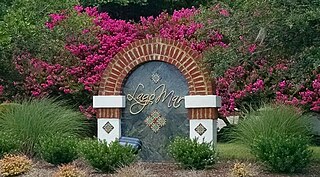
Subdivisions in the general area include: Ashby's Bridge, Asheville Park, Castleton, Christopher Farms, Courthouse Estates, The Estates at Munden Farms, Heritage Park, Highgate Crossing, Highgate Greens, Holland Oaks, Holland Woods, Hunt Club Forest, Indian River Plantation, Lago Mar, Lake Placid, Mayberry, Pine Ridge, Prince George Estates, Princess Anne Woods, Red Mill Farms, Rollingwood, Sherwood Lakes, Strawbridge, Three Oaks and others.

The area boasts an exceptional crime rate, as well as access to some of the best schools in the Virginia Beach City Public Schools system, including Kellam. Its location, in close vicinity to Pungo, the Virginia Beach oceanfront, as well as the coastal community, Sandbridge keeps the area in high demand among new residents.

Like much of the Southeastern United States, the Princess Anne area of Virginia Beach has a subtropical climate, characterized by short, relatively mild winters and long, hot and humid summers. Primarily because of its close proximity to the Atlantic Ocean and location south of the Chesapeake Bay, temperatures are more moderate than those inland, with winters being warmer and averaging only 3 to 4 inches of snow per year. Annually, Princess Anne residents can expect more than to 50 inches of rain. [2]

Whitehurst Buffington House at Princess Anne Courthouse Whitehurst Buffington House.jpg
Whitehurst Buffington House at Princess Anne Courthouse

A wide variety of plants flourish here and can be seen growing throughout the area, including Camellias, Oleanders, Azaleas and Gardenias. Trees include Sabal and Windmill palms, live oak, crepe myrtles, and various magnolia, cherry blossom and fig trees. Loblolly pine, bald cypress, wax myrtle, sweetgum and many other indigenous plants are prevalent as well. Several areas in Princess Anne such as Courthouse and Lago Mar are well established and there are plants in bloom throughout the year.

Climate data for Princess Anne, Virginia Beach, VA (1996–2023)
MonthJanFebMarAprMayJunJulAugSepOctNovDecYear
Record high °F (°C)79
(26)
85
(29)
88
(31)
94
(34)
99
(37)
103
(39)
104
(40)
102
(39)
98
(37)
96
(36)
86
(30)
82
(28)
104
(40)
Mean daily maximum °F (°C)52
(11)
55
(13)
62
(17)
71
(22)
79
(26)
86
(30)
90
(32)
88
(31)
82
(28)
73
(23)
63
(17)
56
(13)
71
(22)
Mean daily minimum °F (°C)36
(2)
38
(3)
44
(7)
52
(11)
61
(16)
70
(21)
74
(23)
73
(23)
68
(20)
58
(14)
47
(8)
40
(4)
55
(13)
Record low °F (°C)12
(−11)
11
(−12)
22
(−6)
33
(1)
42
(6)
51
(11)
60
(16)
60
(16)
52
(11)
37
(3)
28
(−2)
15
(−9)
11
(−12)
Average precipitation inches (mm)3.56
(90.424)
3.49
(88.646)
3.59
(91.186)
4.24
(107.696)
4.35
(110.49)
5.03
(127.762)
6.64
(168.656)
6.17
(156.718)
6.38
(162.052)
4.08
(103.632)
3.75
(95.25)
4.35
(110.49)
55.63
(1,413.002)
Average snowfall inches (mm)2.06
(52.324)
0.61
(15.494)
0.06
(1.524)
0.00
(0.1016)
0.0
(0.0)
0.0
(0.0)
0.0
(0.0)
0.0
(0.0)
0.0
(0.0)
0.0
(0.0)
0.0
(0.0)
0.53
(13.462)
3.26
(82.9056)
Source: Princess Anne Weather

Related Research Articles

<span class="mw-page-title-main">Virginia Beach, Virginia</span> Largest city in Virginia, United States

Virginia Beach is an independent city located on the southeastern coast of Virginia, United States. The population was 459,470 at the 2020 census. Although mostly suburban in character, it is the most populous city in Virginia, fifth-most populous city in the Mid-Atlantic, ninth-most populous city in the Southeast and the 42nd-most populous city in the U.S. Located on the Atlantic Ocean at the mouth of the Chesapeake Bay, Virginia Beach is the largest city in the Hampton Roads metropolitan area which includes 6 other cities. This area, sometimes referred to as "America's First Region", also includes the independent cities of Chesapeake, Hampton, Newport News, Norfolk, Portsmouth, and Suffolk, as well as other smaller cities, counties, and towns of Hampton Roads.

<span class="mw-page-title-main">Hampton Roads</span> Body of water and metropolitan area in the U.S. states of Virginia and North Carolina

Hampton Roads is the name of both a body of water in the United States that serves as a wide channel for the James, Nansemond, and Elizabeth rivers between Old Point Comfort and Sewell's Point where the Chesapeake Bay flows into the Atlantic Ocean, and the surrounding metropolitan region located in the southeastern Virginia and northeastern North Carolina portions of the Tidewater Region.

<span class="mw-page-title-main">South Hampton Roads</span> Region in southeast Virginia

South Hampton Roads is a region located in the extreme southeastern portion of Virginia's Tidewater region in the United States with a total population of 1,191,937. It is part of the Virginia Beach-Norfolk-Newport News, VA-NC MSA, which itself has a population of 1,724,876.

<span class="mw-page-title-main">Norfolk County, Virginia</span>

Norfolk County was a county of the South Hampton Roads in eastern Virginia in the United States that was created in 1691. After the American Civil War, for a period of about 100 years, portions of Norfolk County were lost and the territory of the county reduced as they were annexed by the independent and growing cities of Norfolk, Portsmouth and South Norfolk.

New Norfolk County is a long-extinct county which was located in colonial Virginia from 1636 until 1637.

Lower Norfolk County is a long-extinct county which was organized in colonial Virginia, operating from 1637 until 1691.

<span class="mw-page-title-main">Princess Anne County, Virginia</span>

County of Princess Anne is a former county in the British Colony of Virginia and the Commonwealth of Virginia in the United States, first incorporated in 1691. The county was merged into the city of Virginia Beach on January 1, 1963, ceasing to exist.

<span class="mw-page-title-main">Ocean View (Norfolk)</span> Region of Norfolk, Virginia, US

Ocean View is a coastal region in the independent city of Norfolk, Virginia in the United States. It has several miles of shoreline on the Chesapeake Bay to the north, starting with Willoughby Spit to the west and the Joint Expeditionary Base -- Little Creek in the independent city of Virginia Beach on the east.

<span class="mw-page-title-main">Pungo, Virginia</span> Neighborhood in Virginia Beach, Virginia, United States

Pungo is a rural community located in the southern part of the independent city of Virginia Beach, Virginia and was one of the seven original boroughs when the City of Virginia Beach was created in 1963. The area derives its name from a local Indian tribe, the Machipungo, a branch of the Chesapeake tribe. It was named for a local Indian chief, Machiopungo. Because the community is located in an independent city, there is no individual census for the neighborhood, which was originally part of Princess Anne County until 1963, when the entire county became part of Virginia Beach. Like much of southern Virginia Beach, the area is surrounded by farmland.

Seatack, Virginia is a historic neighborhood and community borough of Virginia Beach, Virginia, that was located in what used to be Princess Anne County, and is now part of the Oceanfront resort strip and adjacent area of the independent city of Virginia Beach. The Seatack community of Virginia Beach includes an area inland from the resort strip along present-day Virginia Beach Boulevard. Seatack Elementary School is located nearby on Birdneck Road. The 1903 Seatack Station of the United States Lifesaving Service is now the Virginia Beach Surf & Rescue Museum at 24th street adjacent to the oceanfront boardwalk.

Thalia is a residential neighborhood in the northeastern area of the independent city of Virginia Beach in the Hampton Roads region of Virginia.

Elzy Burroughs (1771/77–1825) was an American stonemason, engineer, lighthouse builder and keeper.

<span class="mw-page-title-main">Virginia State Route 149</span>

State Route 149 is a primary state highway in the U.S. state of Virginia. Known as Princess Anne Road, the state highway runs 1.92 miles (3.09 km) from SR 165 east to a point near the intersection of Princess Anne Road and General Booth Boulevard within the independent city of Virginia Beach.

<span class="mw-page-title-main">Virginia State Route 165</span>

State Route 165 is a primary state highway in the U.S. state of Virginia. The state highway runs 39.75 miles (63.97 km) from U.S. Route 17 Business in Chesapeake north to SR 337 in Norfolk. SR 165 is a C-shaped route that connects Chesapeake and Norfolk in the Hampton Roads metropolitan area indirectly via Virginia Beach. The highway's east–west segment connects the Chesapeake communities of Deep Creek and Great Bridge with the Princess Anne part of Virginia Beach. SR 165's northwest–southeast portion connects the Princess Anne area with Virginia Beach's Salem and Kempsville communities and with Norfolk. Within Norfolk, the state highway parallels Interstate 64 (I-64) while passing through the eastern and northern areas of the city near Norfolk International Airport and Naval Station Norfolk. Much of SR 165 is a multi-lane divided highway, but there are significant two-lane stretches in all three of the independent cities the highway serves.

<span class="mw-page-title-main">History of Virginia Beach, Virginia</span>

The history of Virginia Beach, Virginia, goes back to the Native Americans who lived in the area for thousands of years before the English colonists landed at Cape Henry in April 1607 and established their first permanent settlement at Jamestown a few weeks later. The Colonial Virginia period extended until 1776 and the American Revolution, and the area has been part of the Commonwealth of Virginia ever since.

Kempsville is a borough in the City of Virginia Beach, Virginia, a historic section with origins in US colonial times located in the former Princess Anne County. In modern times, it is a community within the urbanized portion of the independent city of Virginia Beach, the largest city in Virginia.

<span class="mw-page-title-main">History of Norfolk, Virginia</span> Aspect of history

The history of Norfolk, Virginia as a modern settlement begins in 1636. The city was named after the English county of Norfolk and was formally incorporated in 1736. The city was burned by orders of the outgoing Virginia governor Lord Dunmore in 1776 during the second year of the American Revolutionary War (1775–1783), although it was soon rebuilt.

<span class="mw-page-title-main">Ferry Plantation House</span> Historic house in Virginia, United States

Ferry Plantation House, or Old Donation Farm, Ferry Farm, Walke Manor House, is a brick house in the neighborhood of Old Donation Farm in Virginia Beach, Virginia. The site dates back to 1642 when Savill Gaskin started the second ferry service in Hampton Roads to carry passengers on the Lynnhaven River to the nearby county courthouse and to visit plantations along the waterway. A cannon was used to signal the ferry, which had 11 total stops along the river. The first ferry service was started nearby by Adam Thoroughgood.

<span class="mw-page-title-main">Lago Mar, Virginia Beach, Virginia</span> Neighborhood in Virginia

Lago Mar is a neighborhood on the north end of the Currituck Sound in the Princess Anne area of southeastern Virginia Beach, Virginia, United States. The name translated from Spanish to English means "lake" and "sea". It is derived from its proximity to the Atlantic Ocean and Brinson's Inlet Lake, as well as from the neighboring community of Ocean Lakes. The street names within Lago Mar are also of Spanish origin with the notable exception of Atwoodtown, which is what the area was called prior to being renamed in the 1960s. Today, neighboring communities Ashby's Bridge, Lotus Creek, Mirasol, Parkway Estates, and parts of Sigma are sometimes included in greater Lago Mar, especially for real estate marketing or demographic purposes.

References

  1. "Princess Anne County Historical Society". City of Virginia Beach. Retrieved 1 December 2014.
  2. "Virginia Beach Weather". Weather Underground. Retrieved 13 December 2012.