Opa-locka North, Florida

Last updated
Opa-locka North
Neighborhood of Miami Gardens
FLMap-doton-Opa-lockaNorth.PNG
Location in the state of Florida
Coordinates: 25°55′16″N80°15′46″W / 25.92111°N 80.26278°W / 25.92111; -80.26278
Country United States
State Florida
County Miami-Dade
City Miami Gardens
Area
  Total2.3 sq mi (5.9 km2)
  Land2.2 sq mi (5.6 km2)
  Water0.1 sq mi (0.3 km2)
Population
 (2000)
  Total6,224
  Density2,863.3/sq mi (1,105.5/km2)
Time zone UTC-5 (Eastern (EST))
  Summer (DST) UTC-4 (EDT)
FIPS code 12-51662 [1]

Opa-locka North is a neighborhood in Miami Gardens, Florida, United States. It was formerly a census-designated place. The population was 6,224 at the 2000 census.

Contents

Geography

Opa-locka North is located at 25°55′16″N80°15′46″W / 25.92111°N 80.26278°W / 25.92111; -80.26278 (25.921121, -80.262795). [2]

According to the United States Census Bureau, the CDP has a total area of 5.9 km2 (2.3 mi2). 5.6 km2 (2.2 mi2) of it is land and 0.3 km2 (0.1 mi2) of it (4.80%) is water.

Demographics

Historical population
CensusPop.Note
1980 5,721
1990 6,56814.8%
2000 6,224−5.2%
U.S. Decennial Census [3]
1990 [4] 2000 [5]

As of the census [1] of 2000, there were 6,224 people, 1,502 households, and 1,264 families residing in the CDP. The population density was 1,107.4/km2 (2,863.3/mi2). There were 1,588 housing units at an average density of 282.5/km2 (730.5/mi2). The racial makeup of the CDP was 20.07% White (5.5% were Non-Hispanic White,) [6] 74.98% African American, 0.16% Native American, 0.47% Asian, 0.03% Pacific Islander, 1.83% from other races, and 2.46% from two or more races. Hispanic or Latino of any race were 19.10% of the population.

There were 1,502 households, out of which 41.5% had children under the age of 18 living with them, 44.2% were married couples living together, 31.9% had a female householder with no husband present, and 15.8% were non-families. 11.5% of all households were made up of individuals, and 2.7% had someone living alone who was 65 years of age or older. The average household size was 3.58 and the average family size was 3.79.

In the CDP, the population was spread out, with 28.0% under the age of 18, 21.5% from 18 to 24, 25.4% from 25 to 44, 18.5% from 45 to 64, and 6.6% who were 65 years of age or older. The median age was 25 years. For every 100 females, there were 90.3 males. For every 100 females age 18 and over, there were 83.9 males.

The median income for a household in the CDP was $35,618, and the median income for a family was $32,283. Males had a median income of $25,777 versus $21,112 for females. The per capita income for the CDP was $10,780. About 17.2% of families and 19.9% of the population were below the poverty line, including 23.5% of those under age 18 and 19.1% of those age 65 or over.

As of 2000, before being annexed to Miami Gardens, English as a first language accounted for 75.24% of all residents, while Spanish was spoken by 21.04%, French Creole was at 3.27%, and Jamaican Creole as a mother tongue made up 0.44% of the population. [7]

Education

Miami-Dade County Public Schools operates area public schools. [8] Golden Glades Elementary School is in the former CDP. [9] Jann Mann Educational Center, an alternative middle and high school, is also in the former CDP. [10]

Monsignor Edward Pace High School is in the former CDP. [8] [11]

Florida Memorial University (previously Florida Memorial College) is in the former CDP, as is the SEED Foundation Miami School, on the FMU campus. [8] [12] St. Thomas University is also in the former CDP. [13]

Related Research Articles

<span class="mw-page-title-main">Andover, Florida</span> Neighborhood of Miami Gardens in Miami-Dade, Florida, United States

Andover is a neighborhood in Miami Gardens, Florida. It was formerly a census-designated place. The population was 8,489 at the 2000 census. Transmitters for several Miami television stations are located in Andover.

<span class="mw-page-title-main">Bunche Park, Florida</span> Neighborhood of Miami Gardens in Miami-Dade, Florida, United States

Bunche Park is a neighborhood in Miami Gardens, Florida, United States. It was formerly a census-designated place.

<span class="mw-page-title-main">Carol City, Florida</span> Neighborhood of Miami Gardens in Miami-Dade, Florida, United States

Carol City is a neighborhood in Miami Gardens, Florida, United States. The population was 61,233 at the 2010 census. It was formerly a census-designated place.

<span class="mw-page-title-main">Country Club, Florida</span> Census-designated place in Florida

Country Club is a suburban census-designated place located in northwest Miami-Dade County, Florida, United States. It is located in the Miami metropolitan area of South Florida. The CDP is named after the Country Club of Miami, which was established in 1961 in what was then an unpopulated and undeveloped section of the county. The population was 49,967 at the 2020 census, up from 3,408 in 1990.

<span class="mw-page-title-main">Fontainebleau, Florida</span> Census-designated place in Florida

Fontainebleau(incorrectly spelled "Fountainebleau" in the 2000 census) is a census-designated place (CDP) in Miami-Dade County, Florida, United States. It is part of the Miami metropolitan area of South Florida. The population was 59,870 during the 2020 census.

<span class="mw-page-title-main">Gladeview, Florida</span> Census-designated place in Florida

Gladeview is a census-designated place (CDP) in Miami-Dade County, Florida, United States. It is part of the Miami metropolitan area of South Florida. The population was 14,927 at the 2020 census, up from 11,535 in 2010.

<span class="mw-page-title-main">Golden Glades, Florida</span> Census-designated place in Florida

Biscayne Gardens is a census-designated place (CDP) in Miami-Dade County, Florida, United States. It is part of the Miami metropolitan area of South Florida. The population was 32,499 at the 2020 US census.

<span class="mw-page-title-main">Goulds, Florida</span> Census-designated place in Florida

Goulds is an unincorporated community and census-designated place (CDP) in Miami-Dade County, Florida, United States. The area was originally populated as the result of a stop on the Florida East Coast Railroad. The railroad depot was located near the current Southwest 224th Street. The community was named after its operator, Lyman Gould, who cut trees for railroad ties. It is part of the Miami metropolitan area of South Florida. As of the 2020 US census, the population stood at 11,446, up from 10,103 in 2010 US census.

<span class="mw-page-title-main">Lake Lucerne, Florida</span> Neighborhood of Miami Gardens in Miami-Dade, Florida, United States

Lake Lucerne is a neighborhood in Miami Gardens, Florida. It is formerly a census-designated place. The population was 9,132 at the time of the 2000 United States census.

<span class="mw-page-title-main">Miami Springs, Florida</span> City in Florida

Miami Springs is a city in Miami-Dade County, Florida, United States. The city is part of the Miami metropolitan area of South Florida. As of 2020, the population recorded by the U.S. Census Bureau was 13,859.

Norland, also known as Norwood, is a former census-designated place located in northern Miami-Dade County, Florida. The population was 22,995 at the 2000 census. The latest estimated population stands at 23,500. In 2003 the majority of this CDP was incorporated into the city of Miami Gardens, and it now serves as one of the city's neighborhoods.

<span class="mw-page-title-main">Opa-locka, Florida</span> City in Florida

Opa-locka is a city in Miami-Dade County, Florida, United States. The city is part of the Miami metropolitan area of South Florida. As of the 2020 Census, the population was 16,463, up from 15,219 in 2010.

<span class="mw-page-title-main">Scott Lake, Florida</span> Neighborhood of Miami Gardens in Miami-Dade, Florida, United States

Scott Lake is a neighborhood in Miami Gardens, Florida. It was formerly its own census-designated place. The population was 14,401 at the 2000 census.

<span class="mw-page-title-main">Tamiami, Florida</span> Census-designated place in Florida

Tamiami is a census-designated place (CDP) in Miami-Dade County, Florida, United States. It is part of the Miami metropolitan area of South Florida. The population was 54,212 at the 2020 census.

<span class="mw-page-title-main">The Hammocks, Florida</span> Census-designated place in Florida

The Hammocks is a planned community and census-designated place in Miami-Dade County, Florida, United States. It is part of the Miami metropolitan area of South Florida. The population was 59,480 at the 2020 census, up from 51,003 in 2010.

<span class="mw-page-title-main">University Park, Florida</span> Neighborhood and Former CDP in Miami-Dade, Florida, United States

University Park is a neighborhood and former census-designated place (CDP) located in an unincorporated area of western Miami-Dade County, Florida, United States. It was merged into Westchester CDP for the 2020 U.S. Census. In 2010, the population was 26,995. It encompasses the Modesto A. Maidique Campus of Florida International University and the Fair Expo Center, and was the former name of the former's campus.

<span class="mw-page-title-main">West Little River, Florida</span> CDP in Miami-Dade County, Florida, US

West Little River is a census-designated place (CDP) in Miami-Dade County, Florida, United States. It is part of the Miami metropolitan area of South Florida. The population was 34,128 at the 2020 census.

<span class="mw-page-title-main">Westchester, Florida</span> Census-designated place in Florida

Westchester is a census-designated place (CDP) and neighborhood in Miami-Dade County, Florida. It is part of the Miami metropolitan area of South Florida. Prior to the 2020 U.S. Census, the neighboring University Park CDP was merged into Westchester CDP, effectively doubling its geography and population. Per the 2020 census, the population was 56,384.

<span class="mw-page-title-main">Westview, Florida</span> Census-designated place in Florida

Westview is a census-designated place (CDP) in Miami-Dade County, Florida, United States. It is part of the Miami metropolitan area of South Florida. The population was 9,923 at the 2020 census.

<span class="mw-page-title-main">Miami Gardens, Florida</span> City in the United States

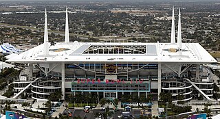
Miami Gardens is a city in north-central Miami-Dade County, Florida, United States. It is located 16 miles (26 km) north of Downtown Miami with city boundaries that stretch from I-95 and Northeast 2nd Avenue to its east to Northwest 47th and Northwest 57th Avenues to its west, and from the Broward County line to its north to 151st Street to its south. The city's name originated from Florida State Road 860, a major roadway through the area also known as Miami Gardens Drive. Miami Gardens had a population of 111,640 as of 2020. It is Florida's most populous city with a majority African American population and also home to the largest percentage of African Americans of any city in Florida, according to the U.S. Census Bureau. It is a principal city in the Miami metropolitan area of South Florida, which is the nation's ninth-largest, and world's 65th-largest metropolitan area with a population of 6.158 million people as of 2020. Miami Gardens is the home of Hard Rock Stadium, a 64,767 capacity multi-purpose stadium that serves as the home field for both the Miami Dolphins of the National Football League and the Miami Hurricanes, the University of Miami's NCAA Division I college football team, which has won five national championships since 1983.

References

  1. 1 2 "U.S. Census website". United States Census Bureau . Retrieved 2008-01-31.
  2. "US Gazetteer files: 2010, 2000, and 1990". United States Census Bureau. 2011-02-12. Retrieved 2011-04-23.
  3. "Decennial Census of Population and Housing by Decades". US Census Bureau.
  4. "1990 Census of Population - Summary Social, Economic, and Housing Characteristics - Florida" (PDF). US Census Bureau . 1990.
  5. "2000 Census of Population - General Population Characteristics - Florida" (PDF). United States Census Bureau. 2000.
  6. "Demographics of Opa-locka North, FL". MuniNetGuide.com. Retrieved 2007-12-15.
  7. "MLA Data Center Results for Opa-locka North, Florida". Modern Language Association . Retrieved 2007-12-15.
  8. 1 2 3 "Census 2000 Block Map: Opa-locka North CDP" (PDF). U.S. Census Bureau. - Pages 1 and 2
  9. "Home". Golden Glades Elementary School. Retrieved 2020-05-11. 16520 NW 8th Avenue Miami Gardens, FL 33054
  10. "JAN MANN EDUCATIONAL CENTER". Miami-Dade County Public Schools. 2020-05-11. 16101 NW 44TH COURT MIAMI GARDENS, FL 33054
  11. "Home". Monsignor Edward Pace High School . Retrieved 2020-10-18. 15600 NW 32 Ave Miami Gardens, FL 33054
  12. "SEED Miami". SEED Foundation . Retrieved 2020-05-11. Campus address: Florida Memorial Univ. 15800 nw 42nd avenue miami gardens, fl 33054
  13. "Campus Map". St. Thomas University . Retrieved 2020-05-12. 16401 NW 37th Avenue, Miami Gardens, FL 33054

Further reading