Baker County, Florida

Last updated

Baker County
Baker County (Macclenny).jpg
Baker County Courthouse in Macclenny
Seal of Baker County, Florida.png
Map of Florida highlighting Baker County.svg
Location within the U.S. state of Florida
Florida in United States.svg
Florida's location within the U.S.
Coordinates: 30°19′N82°16′W / 30.32°N 82.27°W / 30.32; -82.27
CountryFlag of the United States.svg United States
StateFlag of Florida.svg  Florida
FoundedFebruary 8, 1861
Named for James McNair Baker
Seat Macclenny
Largest cityMacclenny
Area
  Total588.97 sq mi (1,525.4 km2)
  Land585.23 sq mi (1,515.7 km2)
  Water3.74 sq mi (9.7 km2)
Population
 (2020)
  Total28,259
  Density48.29/sq mi (18.64/km2)
Time zone UTC−5 (Eastern)
  Summer (DST) UTC−4 (EDT)
Congressional district 3rd
Website www.bakercountyfl.org

Baker County is a county in the U.S. state of Florida. As of the 2020 census, the population was 28,259. [1] Its county seat is Macclenny. [2] The county was founded in 1861 and is named for James McNair Baker, a judge and Confederate Senator.

Contents

Baker County is included in the Jacksonville, Florida Metropolitan Statistical Area.

In 1864, the Battle of Olustee, which was the only major American Civil War battle in Florida, was fought near Lake City in Baker County.

History

Baker County was founded in 1861. It was named for James McNair Baker (1821–1892), a judge and Confederate senator. [3] In 1864 the Battle of Olustee was fought near Lake City in Baker County. This was the only major American Civil War battle in Florida. [4]

Much of the area was originally covered with pine flatwoods and cypress swamps, as was Columbia County to the west. Parts of both counties are included in Osceola National Forest. A lumber industry developed here, with sawmills constructed along rivers and waterways, where lumber was brought out by water. Turpentine was also produced. These industries employed many African American laborers.

Geography

According to the U.S. Census Bureau, the county has a total area of 589 square miles (1,530 km2), of which 585 square miles (1,520 km2) is land and 3.7 square miles (9.6 km2) (0.6%) is water. [5] The extreme northern part of the county lies within the Okefenokee Swamp and its federally protected areas.

The St. Mary's River passes through Baker and numerous other counties. The St. Marys River is a remote blackwater river, rising in southeastern Georgia and flowing into northeastern Florida, where it forms the easternmost border between the two states. [6] [7]

Adjacent counties

National protected areas


Transportation

Major highways

Railroads

The main railroad line through Baker County is the Florida Gulf & Atlantic Railroad which acquired the former CSX lines from Pensacola to Baldwin on June 1, 2019. CSX retained trackage rights on that route. No passenger trains stop anywhere in Baker County, but Amtrak's Sunset Limited served the Tallahassee Subdivision until Hurricane Katrina ravaged the Gulf Coast in 2005.

The other major railroad line in the county is Norfolk Southern Railway's Valdosta District, which spans northwest to southeast from the Okefenokee National Wildlife Refuge at the Georgia State Line, north of the Columbia-Baker County Line, through Baxter at a bridge over the to the Saint Mary's River which cuts through the "Georgia Bend" and eventually leads to the Jacksonville Terminal.

Additionally, the Jacksonville and Southwestern Railroad was a former Atlantic Coast Line Railroad line running through the southeast portion of the county that was abandoned by CSX in 1992. The line has been converted to a rail trail between Baldwin and Jacksonville in Duval County, and in Raiford in Union County, but no known plans exist to connect the two segments.

Demographics

Historical population
CensusPop.Note
1870 1,325
1880 2,30373.8%
1890 3,33344.7%
1900 4,51635.5%
1910 4,8056.4%
1920 5,62217.0%
1930 6,27311.6%
1940 6,5103.8%
1950 6,313−3.0%
1960 7,36316.6%
1970 9,24225.5%
1980 15,28965.4%
1990 18,48620.9%
2000 22,25920.4%
2010 27,11521.8%
2020 28,2594.2%
2023 (est.)28,368 [8] 0.4%
U.S. Decennial Census [9]
1790–1960 [10] 1900–1990 [11]
1990–2000 [12] 2010–2020 [1]
Baker County racial composition as of 2020
(NH = Non-Hispanic) [lower-alpha 1]
RacePop 2010 [15] Pop 2020 [16] % 2010% 2020
White (NH)22,35322,18582.44%78.51%
Black or African American (NH)3,6513,82513.46%13.54%
Native American or Alaska Native (NH)721090.27%0.39%
Asian (NH)1291570.48%0.56%
Pacific Islander (NH)5140.02%0.05%
Some Other Race (NH)13840.05%0.3%
Mixed/Multi-Racial (NH)3729121.37%3.23%
Hispanic or Latino 5209731.92%3.44%
Total27,11528,259

As of the 2020 United States census, there were 28,259 people, 8,828 households, and 6,448 families residing in the county.

As of the census [17] of 2000, there were 22,259 people, 7,043 households, and 5,599 families residing in the county. The population density was 38 inhabitants per square mile (15/km2). There were 7,592 housing units at an average density of 13 per square mile (5.0/km2). The racial makeup of the county was 84.04% White, 13.92% Black or African American, 0.38% Native American, 0.40% Asian, 0.03% Pacific Islander, 0.25% from other races, and 0.98% from two or more races. 1.88% of the population were Hispanic or Latino of any race. 34.5% were of American, 9.9% Irish, 8.6% English and 6.6% German ancestry according to Census 2000. Those claiming "American" ancestry are of predominantly English ancestry but most people in Baker County who are Anglo-European tend to identify simply as American. [18] [19] [20] [21] 97.2% spoke English and 2.5% Spanish as their first language.

There were 7,043 households, out of which 41.20% had children under the age of 18 living with them, 61.70% were married couples living together, 13.10% had a female householder with no husband present, and 20.50% were non-families. 17.10% of all households were made up of individuals, and 6.90% had someone living alone who was 65 years of age or older. The average household size was 2.86 and the average family size was 3.20.

In the county, the population was spread out, with 27.50% under the age of 18, 9.90% from 18 to 24, 30.70% from 25 to 44, 22.70% from 45 to 64, and 9.20% who were 65 years of age or older. The median age was 34 years. For every 100 females there were 119.79 males. For every 100 females age 18 and over, there were 112.40 males.

The median income for a household in the county was $40,035, and the median income for a family was $43,503. Males had a median income of $30,240 versus $21,279 for females. The per capita income for the county was $15,164. About 11.40% of families and 14.70% of the population were below the poverty line, including 22.20% of those under age 18 and 8.60% of those age 65 or over.

Education

The Baker County School District serves public school students in the county.

The main library serving Baker County is the Emily Taber Public Library. The building used to be the Old Baker County Courthouse, built in 1908. The library director is April Teel. [22]

Government

Law enforcement

The Baker County Sheriff's Office is headquartered in Macclenny, Florida. Sheriff Scotty Rhoden was first elected in 2016. [23]

Politics

Voter registration

As of September 1, 2020, Baker County has a Republican majority, with a Democratic minority. [24]

NameNumber of voters%
Democratic 4,44627.2%
Republican 9,91060.7%
Others 1,96312.1%
Total16,319

Statewide elections

United States presidential election results for Baker County, Florida [25]
Year Republican Democratic Third party
No.%No.%No.%
2020 11,91184.58%2,03714.47%1340.95%
2016 10,29481.02%2,11216.62%2992.35%
2012 8,97578.80%2,31120.29%1040.91%
2008 8,67278.22%2,32720.99%880.79%
2004 7,73877.73%2,18021.90%370.37%
2000 5,61168.80%2,39229.33%1521.86%
1996 3,68655.54%2,27334.25%67810.22%
1992 3,41850.59%1,97629.25%1,36220.16%
1988 3,41871.49%1,35528.34%80.17%
1984 3,48571.62%1,38128.38%00.00%
1980 2,28345.88%2,61152.47%821.65%
1976 1,05825.22%2,98571.16%1523.62%
1972 1,94383.64%37916.32%10.04%
1968 29410.72%48717.75%1,96271.53%
1964 1,12149.65%1,13750.35%00.00%
1960 39821.32%1,46978.68%00.00%
1956 36620.23%1,44379.77%00.00%
1952 41922.04%1,48277.96%00.00%
1948 1129.52%84972.19%21518.28%
1944 12710.05%1,13789.95%00.00%
1940 1147.78%1,35292.22%00.00%
1936 1166.94%1,55593.06%00.00%
1932 876.37%1,27893.63%00.00%
1928 67672.38%24225.91%161.71%
1924 12432.72%21556.73%4010.55%
1920 11522.64%34668.11%479.25%
1916 529.25%43978.11%7112.63%
1912 3711.18%16850.76%12638.07%
1908 10430.95%15245.24%8023.81%
1904 12035.40%20761.06%123.54%
Previous gubernatorial elections results
Year Republican Democratic Third parties
2022 89.45%9,59410.18% 1,0920.37% 41
2018 82.37%8,68716.69% 1,7600.94% 99
2014 70.54%5,95624.87% 2,1004.59% 388
2010 62.34%4,94034.46% 2,7313.20% 253
2006 69.39%4,33527.82% 1,7382.79% 174
2002 69.22%4,51530.06% 1,9610.72% 47
1998 71.14%3,26828.86% 1,326
1994 68.52%3,60031.48% 1,654

Industry

Baker County is home to a Walmart distribution center, [26] [27] several small manufacturing businesses, and Acreage Holdings, a cannabis cultivation facility. There are also several local, [28] regional, state (the Baker Correctional Institution), [29] and federal [30] prisons in the western part of the county, bordering several more such facilities [31] in Columbia County.

Communities

City

Town

Unincorporated communities

[32]

See also

Notes

  1. Note: the US Census treats Hispanic/Latino as an ethnic category. This table excludes Latinos from the racial categories and assigns them to a separate category. Hispanics/Latinos can be of any race. [13] [14]

Related Research Articles

<span class="mw-page-title-main">Putnam County, Florida</span> County in Florida, United States

Putnam County is a county located in the northern part of the state of Florida. As of the 2020 census, the population was 73,321. Its county seat is Palatka.

<span class="mw-page-title-main">Clay County, Florida</span> County in Florida, United States

Clay County is located in the northeastern part of the U.S. state of Florida along the west bank of the St. Johns River. As of 2020, the population was 218,245 and in 2023, that number increased to 232,439, making it the third largest county in the Jacksonville metropolitan area. While most of the county is unincorporated, there are 4 municipalities with Green Cove Springs being the county seat and the unincorporated Lakeside CDP being the largest place. It is named in honor of Henry Clay, a famous American statesman, member of the United States Senate from Kentucky, and United States Secretary of State in the 19th century.

<span class="mw-page-title-main">Bradford County, Florida</span> County in Florida, United States

Bradford County is a county in the North central Region of the U.S. state of Florida. As of the 2020 census, the population was 28,303. Its county seat and largest city is Starke.

<span class="mw-page-title-main">Columbia County, Florida</span> County in Florida, United States

Columbia County is a county located in the north central portion of the U.S. state of Florida. As of the 2020 census, the population was 69,698, up from 67,531 at the 2010 census. Its county seat is Lake City.

<span class="mw-page-title-main">Gadsden County, Florida</span> County in Florida, United States

Gadsden County is a county located in the panhandle of the U.S. state of Florida. As of the 2020 census, the population was 43,826. Its county seat is Quincy. Gadsden County is included in the Tallahassee, FL Metropolitan Statistical Area. Gadsden County is the only majority African-American county in Florida.

<span class="mw-page-title-main">Jefferson County, Florida</span> County in Florida, United States

Jefferson County is a county located in the Big Bend region in the northern part of the U.S. state of Florida. As of the 2020 census, the population was 14,510. Its county seat is Monticello.

<span class="mw-page-title-main">Madison County, Florida</span> County in Florida, United States

Madison County is a county located in the north central portion of the state of Florida, and borders the state of Georgia to the north. As of the 2020 census, the population was 17,968. Its county seat is also called Madison.

<span class="mw-page-title-main">Nassau County, Florida</span> County in Florida, United States

Nassau County is the northeasternmost county of the U.S. state of Florida. According to the July 2022 United States Census analysis, the county's population was 97,899, up from 90,352 at the 2020 census.

<span class="mw-page-title-main">Suwannee County, Florida</span> County in Florida, United States

Suwannee County is a county located in the north central portion of the state of Florida. As of the 2020 census, the population was 43,474, up from 41,551 in 2010. Its county seat is Live Oak. Suwannee County was a dry county until August 2011, when the sale of alcoholic beverages became legal in the county.

<span class="mw-page-title-main">Union County, Florida</span> County in Florida, United States

Union County is a county located in the north central portion of the U.S. state of Florida, the smallest in the state by area. As of the 2020 census, the population was 16,147. The county seat is Lake Butler. With a personal per capita income of $26,536, it is one of poorest counties in the United States.

<span class="mw-page-title-main">Clinch County, Georgia</span> County in Georgia, United States

Clinch County is a county located in the southeastern part of the U.S. state of Georgia. As of the 2020 census, the population was 6,749. The county seat is Homerville. The county was created on February 14, 1850, named in honor of Duncan Lamont Clinch.

<span class="mw-page-title-main">Charlton County, Georgia</span> County in Georgia, United States

Charlton County is the southernmost county of the U.S. state of Georgia, located in the southeastern part of the state. As of the 2020 census, the population was 12,518. The county seat is Folkston.

<span class="mw-page-title-main">Macclenny, Florida</span> City in Florida, United States

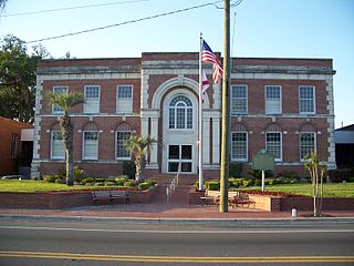
Macclenny is a city and the county seat of Baker County, Florida. Located just west of Jacksonville, it is a municipalities in the Jacksonville, Florida Metropolitan Statistical Area. The population was 7,304 at the 2020 census, up from 6,374 in 2010.

<span class="mw-page-title-main">Lake City, Florida</span> City in Florida, United States

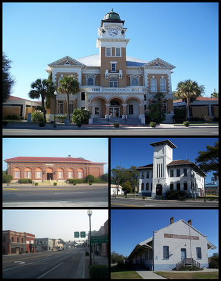
Lake City is a city in and the county seat of Columbia County, Florida, United States. As of the 2020 census, the city's population was 12,329, up from 12,046 at the 2010 census. It is the principal city of the Lake City Micropolitan Statistical Area, composed of Columbia County, as well as a principal city of the Gainesville—Lake City, Florida Combined Statistical Area. Lake City is 60 miles west of Jacksonville.

<span class="mw-page-title-main">Baldwin, Florida</span> Town in the state of Florida, United States

Baldwin is a town in Duval County, Florida, United States. When the majority of communities in Duval County were consolidated with the city of Jacksonville in 1968, Baldwin, along with Jacksonville Beach, Atlantic Beach and Neptune Beach, remained partly independent. Like the other towns, it maintains its own municipal government, but its residents vote in the Jacksonville mayoral election and vote for the Jacksonville City Council; unlike the others, Baldwin no longer supports its own police force. The population was 1,396 at the 2020 census, down from 1,425 at the 2010 census. It is part of the Jacksonville, Florida Metropolitan Statistical Area.

<span class="mw-page-title-main">Callahan, Florida</span> Town in Florida, United States

Callahan is a town in Nassau County, Florida, United States, adjacent to Duval County. The population was 1,526 at the 2020 census, up from 1,123 at the 2010 census. It is part of the Jacksonville, Florida Metropolitan Statistical Area. It is one location of the Northeast Florida Fair.

<span class="mw-page-title-main">Hilliard, Florida</span> Town in the state of Florida, United States

Hilliard is a town in Nassau County, Florida, United States; northwest of Jacksonville. It is part of the Jacksonville, Florida Metropolitan Statistical Area. As of the 2020 census, the population was 2,967, down from 3,086 at the 2010 census.

<span class="mw-page-title-main">Wildwood, Florida</span> City in Florida, United States

Wildwood is a city in Sumter County, Florida, United States. The population was 15,730 at the 2020 census.

<span class="mw-page-title-main">Live Oak, Florida</span> City in Florida, United States

Live Oak is a city and the county seat of Suwannee County, Florida, United States. The city is located at the midpoint between Tallahassee and Jacksonville. As of 2020, the population recorded by the U.S. Census Bureau was 6,735.

<span class="mw-page-title-main">Jarratt, Virginia</span> Town in Virginia, United States

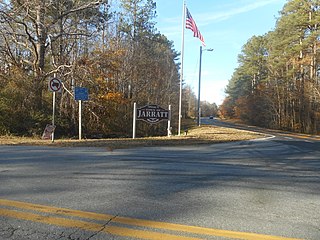
Jarratt is a town in Greensville and Sussex counties in the U.S. state of Virginia. The population was 652 at the 2020 census. In 1848, Jarratt was a stop on the Petersburg Railroad. Jaratt was incorporated in 1938.

References

  1. 1 2 "QuickFacts: Baker County, Florida". United States Census Bureau. Retrieved September 9, 2021.
  2. "Find a County". National Association of Counties. Archived from the original on May 31, 2011. Retrieved June 7, 2011.
  3. Publications of the Florida Historical Society. Florida Historical Society. 1908. p. 30.
  4. "American Battlefield Protection Program Battle Summary". National Park Service. Retrieved February 18, 2017.
  5. "US Gazetteer files: 2010, 2000, and 1990". United States Census Bureau. February 12, 2011. Retrieved April 23, 2011.
  6. "Florida's Water". floridaswater.com. Archived from the original on March 16, 2015. Retrieved March 5, 2015.
  7. "Baker County Geography". stmaryriverbaker.weebly.com. Thomas. Retrieved March 5, 2015.
  8. "Annual Estimates of the Resident Population for Counties: April 1, 2020 to July 1, 2023". United States Census Bureau. Retrieved March 31, 2024.
  9. "U.S. Decennial Census". United States Census Bureau. Retrieved June 12, 2014.
  10. "Historical Census Browser". University of Virginia Library. Retrieved June 12, 2014.
  11. "Population of Counties by Decennial Census: 1900 to 1990". United States Census Bureau. Retrieved June 12, 2014.
  12. "Census 2000 PHC-T-4. Ranking Tables for Counties: 1990 and 2000" (PDF). United States Census Bureau. Retrieved June 12, 2014.
  13. "Census.gov". Census.gov.
  14. "About the Hispanic Population and its Origin". www.census.gov. Retrieved May 18, 2022.
  15. "Explore Census Data". data.census.gov. Retrieved May 27, 2022.
  16. "Explore Census Data". data.census.gov. Retrieved May 27, 2022.
  17. "U.S. Census website". United States Census Bureau . Retrieved May 14, 2011.
  18. Sharing the Dream: White Males in a Multicultural America By Dominic J. Pulera.
  19. Reynolds Farley, 'The New Census Question about Ancestry: What Did It Tell Us?', Demography, Vol. 28, No. 3 (August 1991), pp. 414, 421.
  20. Stanley Lieberson and Lawrence Santi, 'The Use of Nativity Data to Estimate Ethnic Characteristics and Patterns', Social Science Research, Vol. 14, No. 1 (1985), pp. 44-6.
  21. Stanley Lieberson and Mary C. Waters, 'Ethnic Groups in Flux: The Changing Ethnic Responses of American Whites', Annals of the American Academy of Political and Social Science, Vol. 487, No. 79 (September 1986), pp. 82-86.
  22. "Emily Taber Public Library (Baker County) | New River Public Library Cooperative". March 4, 2016. Archived from the original on March 4, 2016. Retrieved March 27, 2018.
  23. "Rhoden wins race". Jacksonville.com. Retrieved February 28, 2017.
  24. "Baker County Supervisor of Elections > Voter Information > Statistic Reports".
  25. Leip, David. "Dave Leip's Atlas of U.S. Presidential Elections". uselectionatlas.org.
  26. "Neighbors irked by Walmart DC, Who knew?". Baker County Press. April 2012. Retrieved March 10, 2021.
  27. "Wal-Mart D.C. #6099 - Macclenny, FL" . Retrieved March 10, 2021.
  28. "Corrections Department". Baker County Sheriff's Office. Archived from the original on October 18, 2020. Retrieved March 10, 2021.
  29. "Baker Re-Entry Center". Florida Department of Corrections. Retrieved March 10, 2021.
  30. "Baker County Facility". U.S. Immigration and Customs Enforcement. Retrieved March 10, 2021.
  31. "Columbia Correctional Institution". Florida Department of Corrections. Retrieved March 10, 2021.
  32. "Google Maps". Google Maps.

Government links/Constitutional offices

Special districts

Judicial branch

Community Web Pages

Federal

Museum and Library Resources

30°19′N82°16′W / 30.32°N 82.27°W / 30.32; -82.27