Fruit Cove, Florida

Last updated

Fruit Cove, Florida
CDP
FruitCoveCFL.png
Julington Creek, Fruit Cove Baptist Church, Julington Creek Community Park
St. Johns County Florida Incorporated and Unincorporated areas Fruit Cove Highlighted.svg
Location in St. Johns County and the state of Florida
Coordinates: 30°6′4″N81°37′6″W / 30.10111°N 81.61833°W / 30.10111; -81.61833
Country Flag of the United States.svg  United States
State Flag of Florida.svg  Florida
County   St. Johns
Area
[1]
  Total18.48 sq mi (47.87 km2)
  Land16.11 sq mi (41.74 km2)
  Water2.37 sq mi (6.14 km2)
Elevation
10 ft (3 m)
Population
 (2020)
  Total32,143
  Density1,994.60/sq mi (770.14/km2)
Time zone UTC-5 (Eastern (EST))
  Summer (DST) UTC-4 (EDT)
FIPS code 12-24925 [2]
GNIS feature ID0307970 [3]

Fruit Cove is a census-designated place (CDP) in St. Johns County, Florida, United States. It is located in the community of St. Johns. The population was 32,143 at the 2020 census, up from 29,362 at the 2010 census. It is part of the Jacksonville, Florida Metropolitan Statistical Area.

Contents

Geography

Fruit Cove is located at 30°6′4″N81°37′6″W / 30.10111°N 81.61833°W / 30.10111; -81.61833 (30.101153, -81.618318). [4]

According to the United States Census Bureau, the CDP has a total area of 17.9 square miles (46 km2), of which 17.9 square miles (46 km2) is land and 0.06% is water.

Fruit Cove is the location of the Marywood Retreat Center for the Diocese of St. Augustine.

Demographics

Historical population
CensusPop.Note
1990 5,904
2000 16,077172.3%
2010 29,36282.6%
2020 32,1439.5%
U.S. Decennial Census [5]

2010 and 2020 census

Fruit Cove racial composition
(Hispanics excluded from racial categories)
(NH = Non-Hispanic)
RacePop 2010 [6] Pop 2020 [7] % 2010% 2020
White (NH)25,36825,37686.40%78.95%
Black or African American (NH)9501,0603.24%3.30%
Native American or Alaska Native (NH)58590.20%0.18%
Asian (NH)7661,1852.61%3.69%
Pacific Islander or Native Hawaiian (NH)7120.02%0.04%
Some other race (NH)451920.15%0.60%
Two or more races/Multiracial (NH)4771,5161.62%4.72%
Hispanic or Latino (any race)1,6912,7435.76%8.53%
Total29,36232,143

As of the 2020 United States census, there were 32,143 people, 10,909 households, and 9,269 families residing in the CDP. [8]

As of the 2010 United States census, there were 29,362 people, 9,487 households, and 8,085 families residing in the CDP. [9]

2000 census

At the 2000 census there were 16,077 people, 5,294 households, and 4,600 families in the CDP. The population density was 900.2 inhabitants per square mile (347.6/km2). There were 5,549 housing units at an average density of 310.7 per square mile (120.0/km2). The racial makeup of the CDP was 94.76% White, 2.06% Black, 0.18% Native American, 1.61% Asian, 0.14% Pacific Islander, 0.44% from other races, and 0.81% from two or more races. Hispanic or Latino of any race were 2.38%. [2]

Of the 5,294 households 50.6% had children under the age of 18 living with them in 2000, 79.4% were married couples living together, 5.7% had a female householder with no husband present. 10.9% of households were one person and 5.0% were one person aged 65 or older. The average household size was 3.02 and the average family size was 3.26.

In 2000, the age distribution was 32.3% under the age of 18, 4.3% from 18 to 24, 31.8% from 25 to 44, 23.9% from 45 to 64, and 7.7% 65 or older. The median age was 37 years. For every 100 females, there were 100.4 males. For every 100 females age 18 and over, there were 94.5 males.

In 2000, the median household income was $82,159 and the median family income was $84,791. Males had a median income of $62,470 versus $35,775 for females. The per capita income for the CDP was $30,462. About 1.6% of families and 1.9% of the population were below the poverty line, including 2.0% of those under age 18 and 1.7% of those age 65 or over.

Education

St. Johns County School District is the school district of the area. [10]

The following elementary schools serve portions: [11] Cunningham Creek, Durbin Creek, Freedom Crossing, Hickory Creek, and Julington Creek. [12]

Three middle schools serve portions: Freedom Crossing, Fruit Cove, and Switzerland Point. [13]

Two high schools serve portions: Bartram Trail High School and Creekside High School. [14]

St Johns County Public Library System operates the Bartram Trail Branch. [15]

Related Research Articles

<span class="mw-page-title-main">St. Johns County, Florida</span> County in Florida, United States

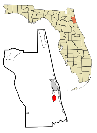
St. Johns County is a county in the northeastern part of the U.S. state of Florida. As of the 2020 United States census, its population was 273,425. The county seat and most populous incorporated city is St. Augustine, although the nearby community, St. Johns, has a higher population. St. Johns County is part of the Jacksonville, Florida Metropolitan Statistical Area.

<span class="mw-page-title-main">Palm City, Florida</span> Census-designated place in Florida, United States

Palm City is an unincorporated area and census-designated place (CDP) in Martin County, Florida, United States. The population was 25,883 at the 2020 census. It is part of the Port St. Lucie Metropolitan Statistical Area.

<span class="mw-page-title-main">Glenvar Heights, Florida</span> Census-designated place in Florida

Glenvar Heights is a census-designated place (CDP) and neighborhood in Miami-Dade County, Florida, United States. It is part of the Miami metropolitan area of South Florida. The population was 20,786 at the 2020 US census, up from 16,898 in 2010 US census.

<span class="mw-page-title-main">Kendall, Florida</span> Census-designated place in Florida

Kendall is an unincorporated area and census-designated place in Miami-Dade County, Florida. It is part of the Miami metropolitan area of South Florida. At the 2020 census, the area had a population of 80,241.

<span class="mw-page-title-main">Kendall West, Florida</span> Census-designated place in Florida

Kendall West is a census-designated place and unincorporated community in Miami-Dade County, Florida, west of the Florida Turnpike. It is located in the Miami metropolitan area of South Florida. The population was 36,536 at the 2020 census.

<span class="mw-page-title-main">Olympia Heights, Florida</span> Census-designated place in Florida

Olympia Heights is a census-designated place in Miami-Dade County, Florida, United States. It is located in the Miami metropolitan area of South Florida. The population was 12,873 at the 2020 census.

<span class="mw-page-title-main">Sunset, Florida</span> Census-designated place in Florida

Sunset is a census-designated place (CDP) in Miami-Dade County, Florida, United States. It is part of the Miami metropolitan area of South Florida. The population was 15,912 at the 2020 census. The U.S. Postal Service uses the ZIP Codes of 33173 and 33183 for Sunset.

<span class="mw-page-title-main">The Hammocks, Florida</span> Census-designated place in Florida

The Hammocks is a planned community and census-designated place in Miami-Dade County, Florida, United States. It is part of the Miami metropolitan area of South Florida. The population was 59,480 at the 2020 census, up from 51,003 in 2010.

<span class="mw-page-title-main">Hunter's Creek, Florida</span> Census-designated place in Florida, United States

Hunter's Creek is a master planned, unincorporated community and census-designated place in Orange County, Florida, United States. It is part of the Orlando–Kissimmee–Sanford, Florida Metropolitan Statistical Area. The population was 14,321 at the 2010 census. It has grown up around a large planned community named Hunter's Creek, though the CDP name given by the United States Census Bureau lacks the apostrophe.

<span class="mw-page-title-main">Tildenville, Florida</span> Census-designated place in Florida, United States

Tildenville is a census-designated place (CDP) and an unincorporated area in Orange County, Florida, United States. The population was 511 at the 2010 census, most of them African American. It is part of the Orlando–Kissimmee Metropolitan Statistical Area. Generally speaking, Tildenville is a narrow area alongside Orange County Road 545, south of Florida State Road 50 and north of the Stoneybrook West planned unit development. Residents utilize Winter Garden, Florida for mail delivery. The CDP takes its name from Luther F. Tilden, a prominent pioneer and citrus magnate who greatly contributed to the community. Historically, Tildenville referred to an area larger than the modern CDP. Landmarks such as Tildenville Elementary School, Tildenville Marketplace, and Meadow Marsh are now located within the city limits of Winter Garden.

<span class="mw-page-title-main">Butler Beach, Florida</span> CDP in Florida, United States

Butler Beach is a census-designated place (CDP) in St. Johns County, Florida, United States. The population was 4,978 at the time of the 2020 United States Census, up from 4,951 at the 2010 census. It is part of the Jacksonville, Florida Metropolitan Statistical Area. Established by Frank B. Butler, who had been successful operating a grocery store and became a political activist, it was a resort for African Americans. The Lincolnville businessman bought land in the area between the Atlantic Ocean and the Matanzas River, and offered beach access to African Americans. It was the only beach open to them between Jacksonville and Daytona Beach.

<span class="mw-page-title-main">St. Augustine Shores, Florida</span> CDP in Florida, United States

St. Augustine Shores is a census-designated place (CDP) in St. Johns County, Florida, United States. As of the 2020 census, the population was 8,706, up from 7,359 at the 2010 census. It is part of the Jacksonville, Florida Metropolitan Statistical Area.

<span class="mw-page-title-main">Vilano Beach, Florida</span> Census-designated place in Florida, United States

Vilano Beach is an unincorporated community and census-designated place (CDP) and in St. Johns County, Florida, United States. It was listed as the Villano Beach CDP by the U.S. Census Bureau from 2010 to 1990; however, the name was corrected to Vilano Beach for the 2020 census. The population was 2,514 at the 2020 census, down from 2,678 at the 2010 census. It is part of the Jacksonville, Florida Metropolitan Statistical Area.

<span class="mw-page-title-main">St. Augustine South, Florida</span> CDP in Florida, United States

St. Augustine South is a census-designated place (CDP) in St. Johns County, Florida, United States. The population was 5,066 at the 2020 census, up from 4,998 at the 2010 census. It is part of the Jacksonville, Florida Metropolitan Statistical Area.

Poinciana is a settlement and census-designated place (CDP) in Osceola and Polk counties in the U.S. state of Florida. It is part of the Greater Orlando area. As of the 2020 census, the CDP had a population of 69,309.

<span class="mw-page-title-main">Switzerland, Florida</span> Community in Florida, United States

Switzerland is an unincorporated community in northwest St. Johns County, Florida, United States, adjacent to Fruit Cove.

Fleming Island is an unincorporated community and census-designated place (CDP) in Clay County, Florida, United States. It is located 21 miles (34 km) southwest of downtown Jacksonville, on the western side of the St. Johns River, off US 17. As of the 2020 census the Fleming Island CDP had a population of 29,142, up from 27,126 at the 2010 census. It is part of the Jacksonville, Florida Metropolitan Statistical Area. Fleming Island's ZIP code became 32003 in 2004, giving it a different code from Orange Park, the incorporated town to the north.

<span class="mw-page-title-main">World Golf Village</span> Census-designated place in Florida, United States

The World Golf Village (WGV) is a golf resort in St. Johns County, Florida, United States, located between Jacksonville and St. Augustine. It was created by the PGA Tour and showcases the World Golf Hall of Fame. In addition to the resort the World Golf Village features residential and commercial developments. There is also a census-designated place with the same name.

<span class="mw-page-title-main">Nocatee, Florida</span> Planned community in Florida

Nocatee is an unincorporated planned community and census-designated place (CDP) located primarily in northern St. Johns County, Florida. The population was 22,503 at the 2020 census, up from 4,524 at the 2010 census, an increase of nearly 400%. It is part of the Jacksonville, Florida Metropolitan Statistical Area. As of 2020, the community consists of twenty-two neighborhoods, some of which are specialized for certain age groups. The community blends a variety of neighborhoods with schools, parks, recreation, offices, shopping, and restaurants. Part of the development lies within Jacksonville city limits in Duval County, although the CDP lies entirely within St. Johns County. It is near Ponte Vedra Beach in Florida's First Coast region and sits on 13,323 acres (5,392 ha) of land. It was approved in 2001 as a Development of Regional Impact (DRI) under Section 380.06 of the Florida Statutes.

<span class="mw-page-title-main">Alafaya, Florida</span> Census-designated place in Florida, United States

Alafaya is a census-designated place and unincorporated area in Orange County, Florida, United States. The population was 92,452 at the 2020 US census. It is part of the Orlando–Kissimmee–Sanford, Florida Metropolitan Statistical Area. It is most known for being near the University of Central Florida, Avalon Park and Waterford Lakes.

References

  1. "2020 U.S. Gazetteer Files". United States Census Bureau. Retrieved October 31, 2021.
  2. 1 2 "U.S. Census website". United States Census Bureau . Retrieved January 31, 2008.
  3. "US Board on Geographic Names". United States Geological Survey. October 25, 2007. Retrieved January 31, 2008.
  4. "US Gazetteer files: 2010, 2000, and 1990". United States Census Bureau. February 12, 2011. Retrieved April 23, 2011.
  5. "Census of Population and Housing". Census.gov. Retrieved June 4, 2016.
  6. "P2 HISPANIC OR LATINO, AND NOT HISPANIC OR LATINO BY RACE - 2010: DEC Redistricting Data (PL 94-171) - Fruit Cove CDP, Florida". United States Census Bureau .
  7. "P2 HISPANIC OR LATINO, AND NOT HISPANIC OR LATINO BY RACE - 2020: DEC Redistricting Data (PL 94-171) - Fruit Cove CDP, Florida". United States Census Bureau .
  8. "S1101 HOUSEHOLDS AND FAMILIES - 2020: Fruit Cove CDP, Florida". United States Census Bureau .
  9. "S1101 HOUSEHOLDS AND FAMILIES - 2010: Fruit Cove CDP, Florida". United States Census Bureau .
  10. "2020 CENSUS - SCHOOL DISTRICT REFERENCE MAP: St. Johns County, FL" (PDF). U.S. Census Bureau . Retrieved August 1, 2022. - Text list - Shows Fruit Cove in the school district boundaries.
  11. "2020 CENSUS - CENSUS BLOCK MAP (INDEX): Fruit Cove CDP, FL" (PDF). U.S. Census Bureau . Retrieved August 1, 2022. - Compare with school zone maps.
  12. "St. Johns County Elementary School Attendance Zones 2022 - 2023" (PDF). St. Johns County School District. Archived from the original (PDF) on August 2, 2022. Retrieved August 1, 2022. - Cunningham Creek Zone Detail, Durbin Creek Zone Detail, Freedom Crossing ES Zone Detail, Hickory Creek Zone Detail, and Julington Creek Zone Detail - Maps from here
  13. "St. Johns County Middle School Attendance Zones 2022 - 2023" (PDF). St. Johns County School District. Archived from the original (PDF) on August 2, 2022. Retrieved August 1, 2022. - Freedom Crossing MS Zone Detail, Fruit Cove MS Zone Detail, and Switzerland Point MS Zone Detail, Maps from here
  14. "St. Johns County High School Attendance Zones 2022 - 2023" (PDF). St. Johns County School District. Archived from the original (PDF) on August 2, 2022. Retrieved August 1, 2022. - Bartram Trail HS Zone Detail - Creekside HS Zone Detail - Maps from here
  15. "Bartram Trail Branch". St Johns County Public Library System . Retrieved August 2, 2022. 60 Davis Pond Blvd. Fruit Cove, FL 32259