Butler Beach, Florida

Last updated

Butler Beach, Florida
CDP
St. Johns County Florida Incorporated and Unincorporated areas Butler Beach Highlighted.svg
Location in St. Johns County and the state of Florida
Coordinates: 29°48′1″N81°15′48″W / 29.80028°N 81.26333°W / 29.80028; -81.26333
Country Flag of the United States.svg  United States
State Flag of Florida.svg  Florida
County   St. Johns
Area
[1]
  Total2.66 sq mi (6.88 km2)
  Land2.54 sq mi (6.59 km2)
  Water0.11 sq mi (0.29 km2)
Elevation
3 ft (1 m)
Population
 (2020)
  Total4,978 [2]
  Density1,956.76/sq mi (755.58/km2)
Time zone UTC-5 (Eastern (EST))
  Summer (DST) UTC-4 (EDT)
FIPS code 12-09630 [2]
GNIS feature ID1867122 [3]

Butler Beach is a census-designated place (CDP) in St. Johns County, Florida, United States. The population was 4,978 at the time of the 2020 United States Census, up from 4,951 at the 2010 census. It is part of the Jacksonville, Florida Metropolitan Statistical Area. Established by Frank B. Butler, [4] who had been successful operating a grocery store and became a political activist, it was a resort for African Americans. [5] The Lincolnville businessman bought land in the area between the Atlantic Ocean and the Matanzas River, and offered beach access to African Americans. It was the only beach open to them between Jacksonville and Daytona Beach. [6]

Contents

Geography

Butler Beach is located at 29°48′1″N81°15′48″W / 29.80028°N 81.26333°W / 29.80028; -81.26333 (29.800353, -81.263425). [7] According to the United States Census Bureau, the CDP has a total area of 2.5 square miles (6.5 km2), all land.

Demographics

Historical population
CensusPop.Note
1990 3,377
2000 4,43631.4%
2010 4,95111.6%
2020 4,9780.5%
U.S. Decennial Census [8]

As of the census [9] of 2000, there were 4,436 people, 2,152 households, and 1,385 families residing in the CDP. The population density was 1,783.0 inhabitants per square mile (688.4/km2). There were 3,694 housing units at an average density of 1,484.8 per square mile (573.3/km2). The racial makeup of the CDP was 97.97% White, 0.29% African American, 0.18% Native American, 0.70% Asian, 0.41% from other races, and 0.45% from two or more races. Hispanic or Latino of any race were 1.49% of the population.

There were 2,152 households, out of which 13.6% had children under the age of 18 living with them, 57.8% were married couples living together, 4.8% had a female householder with no husband present, and 35.6% were non-families. 28.0% of all households were made up of individuals, and 12.7% had someone living alone who was 65 years of age or older. The average household size was 2.06 and the average family size was 2.47.

In the CDP, the population was spread out, with 12.1% under the age of 18, 4.3% from 18 to 24, 19.6% from 25 to 44, 34.4% from 45 to 64, and 29.6% who were 65 years of age or older. The median age was 54 years. For every 100 females, there were 94.8 males. For every 100 females age 18 and over, there were 93.4 males.

The median income for a household in the CDP was $46,319, and the median income for a family was $61,850. Males had a median income of $36,875 versus $31,399 for females. The per capita income for the CDP was $31,193. About 4.2% of families and 6.3% of the population were below the poverty line, including 10.2% of those under age 18 and 3.6% of those age 65 or over.

Education

It is in the St. Johns County School District. [10] Zoned schools include W. D. Hartley Elementary School, [11] Gamble Rogers Middle School, [12] and Pedro Menendez High School. [13]

Related Research Articles

<span class="mw-page-title-main">East Fork, Arizona</span> CDP in Navajo County, Arizona

East Fork is a census-designated place (CDP) in Navajo County, Arizona, United States, on the Fort Apache Indian Reservation. The population was 699 at the 2010 census.

<span class="mw-page-title-main">Kent Acres, Delaware</span> CDP in Delaware, United States

Kent Acres is a census-designated place (CDP) in Kent County, Delaware, United States. It is part of the Dover, Delaware Metropolitan Statistical Area. The population was 1,890 at the 2010 census.

<span class="mw-page-title-main">Woodside East, Delaware</span> CDP in Delaware, United States

Woodside East is a census-designated place (CDP) in Kent County, Delaware, United States. It is part of the Dover, Delaware Metropolitan Statistical Area. The population was 2,316 at the 2010 census.

<span class="mw-page-title-main">Greenville, Delaware</span> CDP in Delaware, United States

Greenville is a bedroom community in New Castle County, Delaware, United States, and a suburb of Wilmington. The population was 2,326 at the 2010 census. For statistical purposes, the United States Census Bureau has defined Greenville as a census-designated place (CDP). The community is also home to the private residence of Joe Biden, the 46th and current president of the United States, and many Du Pont family descendants.

North Star is a census-designated place (CDP) in New Castle County, Delaware, United States. The population was 7,980 at the 2010 census.

<span class="mw-page-title-main">Marineland, Florida</span> Town in the state of Florida, United States

The town of Marineland was established in 1940, and is in both Flagler and St. Johns counties, Florida, United States. Marineland is located 18 miles (29 km) south of St. Augustine along Route A1A. The population was 15 in the 2020 census.

<span class="mw-page-title-main">Crescent Beach, St. Johns County, Florida</span> CDP in Florida, United States

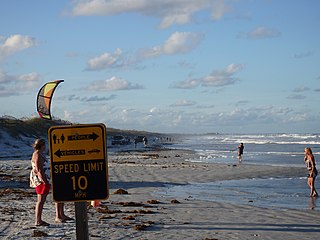
Crescent Beach is an unincorporated census-designated place in St. Johns County, Florida, United States. The population was 844 at the 2020 census, down from 931 at the 2010 census. It is part of the Jacksonville, Florida Metropolitan Statistical Area.

<span class="mw-page-title-main">Fruit Cove, Florida</span> CDP in Florida, United States

Fruit Cove is a census-designated place (CDP) in St. Johns County, Florida, United States. It is located in the community of St. Johns. The population was 32,143 at the 2020 census, up from 29,362 at the 2010 census. It is part of the Jacksonville, Florida Metropolitan Statistical Area.

<span class="mw-page-title-main">Palm Valley, Florida</span> CDP in Florida, United States

Palm Valley is a census-designated place (CDP) in St. Johns County, Florida, United States. The population was 21,827 at the 2020 census, up from 20,019 at the 2010 census. It is part of the Jacksonville, Florida Metropolitan Statistical Area.

<span class="mw-page-title-main">Sawgrass, Florida</span> CDP in Florida, United States

Sawgrass is a census-designated place (CDP) in St. Johns County, Florida, United States. The population was 5,385 at the 2020 census, up from 4,880 at the 2010 census. The area is located in Ponte Vedra Beach and part of the Jacksonville, Florida Metropolitan Statistical Area. Sawgrass is home to The Players Championship (TPC), established in 1974. The tournament offers the highest prize fund of any tournament in golf.

<span class="mw-page-title-main">St. Augustine Shores, Florida</span> CDP in Florida, United States

St. Augustine Shores is a census-designated place (CDP) in St. Johns County, Florida, United States. As of the 2020 census, the population was 8,706, up from 7,359 at the 2010 census. It is part of the Jacksonville, Florida Metropolitan Statistical Area.

<span class="mw-page-title-main">Vilano Beach, Florida</span> Census-designated place in Florida, United States

Vilano Beach is an unincorporated community and census-designated place (CDP) and in St. Johns County, Florida, United States. It was listed as the Villano Beach CDP by the U.S. Census Bureau from 2010 to 1990; however, the name was corrected to Vilano Beach for the 2020 census. The population was 2,514 at the 2020 census, down from 2,678 at the 2010 census. It is part of the Jacksonville, Florida Metropolitan Statistical Area.

<span class="mw-page-title-main">Candler-McAfee, Georgia</span> Place in Georgia, United States

Candler-McAfee is an unincorporated community and census-designated place (CDP) in DeKalb County, Georgia, United States. It is located east of Atlanta approximately 10 miles (16 km) east of Downtown Atlanta and to the south of Decatur, Georgia The population was 23,025 at the 2010 census.

<span class="mw-page-title-main">Coral Hills, Maryland</span> Census-designated place in Maryland

Coral Hills is an unincorporated area and census-designated place (CDP) in Prince George's County, Maryland, United States. As of the 2020 census, the population was 9,997.

<span class="mw-page-title-main">Woodmore, Maryland</span> Census-designated place in Maryland

Woodmore is an unincorporated area and census-designated place in Prince George's County, Maryland, United States. Per the 2020 census, the population was 4,513. The CDP is located within the boundaries of Route 193 to the west, Church Road to the east, Route 214 to the south and Route 50 to the north. Woodmore Road runs east and west through the center. It contains a large gated community and country club, developments of Woodmore Meadows, and Woodmore South on the south side, as well as various other custom built homes and farmland.

<span class="mw-page-title-main">St. Augustine Beach, Florida</span> City in Florida, United States

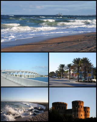
St. Augustine Beach is a city in St. Johns County, Florida, United States. The population was 6,803 at the 2020 US census, up from 6,176 at the 2010 census. It is part of the Jacksonville, Florida Metropolitan Statistical Area.

<span class="mw-page-title-main">St. Augustine South, Florida</span> CDP in Florida, United States

St. Augustine South is a census-designated place (CDP) in St. Johns County, Florida, United States. The population was 5,066 at the 2020 census, up from 4,998 at the 2010 census. It is part of the Jacksonville, Florida Metropolitan Statistical Area.

Green Hill is a census-designated place (CDP) in western Wilson County, Tennessee. The population was 6,618 at the 2010 census.

<span class="mw-page-title-main">Barton Creek, Texas</span> CDP in Texas, United States

Barton Creek is a census-designated place (CDP) in Travis County, Texas, United States. As of the 2020 census, the CDP population was 3,356.

<span class="mw-page-title-main">Lake Butler, Orange County, Florida</span> Census-designated place in Florida, United States

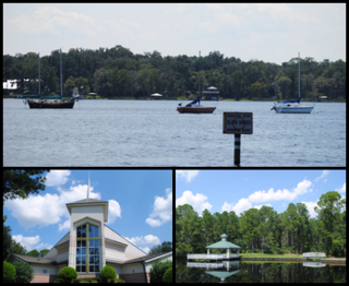
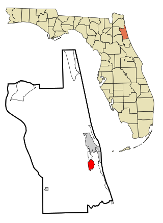
Lake Butler is a census-designated place (CDP) and unincorporated area, completely surrounding the town of Windermere, in Orange County, Florida, United States. The population was 15,400 at the 2010 census, up from 7,062 at the 2000 census. It is part of the Orlando–Kissimmee–Sanford, Florida Metropolitan Statistical Area.

References

  1. "2020 U.S. Gazetteer Files". United States Census Bureau. Retrieved October 31, 2021.
  2. 1 2 "U.S. Census website". United States Census Bureau . Retrieved April 22, 2022.
  3. "US Board on Geographic Names". United States Geological Survey. October 25, 2007. Retrieved January 31, 2008.
  4. "Frank B. Butler - St Augustine Historical Society". February 24, 2020.
  5. Robertson, Ashley N. (2015). Mary Mcleod Bethune in Florida: Bringing Social Justice to the Sunshine State. Arcadia Publishing. p. 67. ISBN   978-1-62619-983-5.
  6. "The Florida Black Heritage Trail".
  7. "US Gazetteer files: 2010, 2000, and 1990". United States Census Bureau. February 12, 2011. Retrieved April 23, 2011.
  8. "Census of Population and Housing". Census.gov. Retrieved June 4, 2016.
  9. "U.S. Census website". United States Census Bureau . Retrieved January 31, 2008.
  10. "2020 CENSUS - CENSUS BLOCK MAP: Butler Beach CDP, FL" (PDF). U.S. Census Bureau . Retrieved August 1, 2022. - Compare to the school zone maps.
  11. "St. Johns County Elementary School Attendance Zones 2021 - 2022 W. D. Hartley Elementary School" (PDF). St. Johns County School District. Archived from the original (PDF) on December 3, 2021. Retrieved December 3, 2021. - See index of maps
  12. "St. Johns County Middle School Attendance Zones 2021 - 2022 Gamble Rogers Middle School" (PDF). St. Johns County School District. Archived from the original (PDF) on December 3, 2021. Retrieved December 3, 2021. - See index of maps
  13. "St. Johns County High School Attendance Zones 2021 - 2022 Pedro Menendez High School" (PDF). St. Johns County School District. Archived from the original (PDF) on December 3, 2021. Retrieved December 3, 2021. - See index of maps