Palm Valley, Florida

Last updated

Palm Valley, Florida
CDP
Nickname(s): 
"The Valley", "Paradise Valley"
St. Johns County Florida Incorporated and Unincorporated areas Palm Valley Highlighted.svg
Location in St. Johns County and the state of Florida
Coordinates: 30°12′24″N81°23′14″W / 30.20667°N 81.38722°W / 30.20667; -81.38722
Country Flag of the United States.svg  United States
State Flag of Florida.svg  Florida
County   St. Johns
Area
[1]
  Total13.61 sq mi (35.25 km2)
  Land12.20 sq mi (31.59 km2)
  Water1.41 sq mi (3.66 km2)
Elevation
7 ft (2 m)
Population
 (2020)
  Total21,827
  Density1,789.69/sq mi (691.01/km2)
Time zone UTC-5 (Eastern (EST))
  Summer (DST) UTC-4 (EDT)
Area code 904
FIPS code 12-54525 [2]
GNIS feature ID0308066 [3]

Palm Valley is a census-designated place (CDP) in St. Johns County, Florida, United States. The population was 21,827 at the 2020 census, up from 20,019 at the 2010 census. [4] It is part of the Jacksonville, Florida Metropolitan Statistical Area.

Contents

History

Long before the first Spanish settlers arrived, there was an Indian village in what is known as Palm Valley today. Several Indian mounds have been uncovered revealing points, pottery and human skeletons. Early Franciscan missionaries constructed a mission in the area called The Nativity of Our Lady of Tolomato.

By 1703, Don Diego Espinoza had settled in what is today the Palm Valley area. His vast ranch and the surrounding territory was known as Diego Plains. In the 1730s, the ranch was fortified to protect its inhabitants from Indian attack. By 1739, Great Britain and Spain were at war and trouble was brewing for the Diego Plains settlers. British general James Oglethorpe was commissioned to harass the Spanish settlements south of the colony of Georgia, so the Spanish governor fortified the Diego farmhouse which was already being called Fort San Diego. After Oglethorpe’s failure to capture St. Augustine, the Spanish military abandoned Fort San Diego, but other inhabitants moved into the area, living off the land and the cattle.

In 1908, a canal was dug through Diego Plains connecting the San Pablo River to the north with the Tolomato River near St. Augustine to the south. This intracoastal canal made access to the valley much easier for the residents that had settled in this area. In addition to raising cattle, they farmed, logged, and sold palm fronds to religious groups. The many palm trees growing in the region led some of the settlers to decide on the name Palm Valley for their community.

Prohibition turned some of the valley residents to another source of income – moonshine. The abundant water supply and deep woods areas in the valley were ideal for the concealment of illegal whiskey distilling. The moonshine industry thrived even after the Volstead Act was repealed in 1933, but the rising price of sugar finally brought the illegal whiskey industry to an end.

Palm Valley remained a quiet area of the Beaches, between A1A and U.S. 1. There were many farms where produce and livestock were raised. The development of the Beaches has also affected Palm Valley. Today most farms in the valley have disappeared, opening the land for luxurious residences overlooking the Intracoastal Waterway. [5]

Geography

Palm Valley is located at 30°12′24″N81°23′14″W / 30.20667°N 81.38722°W / 30.20667; -81.38722 (30.206580, -81.387256). [6]

According to the United States Census Bureau, the CDP has a total area of 14.0 square miles (36 km2), of which 13.4 square miles (35 km2) is land and 0.6 square miles (1.6 km2) (4.21%) is water.

The Palm Valley Bridge is a recent addition to the neighborhood.

Neighborhoods

There are approximately six formal neighborhoods with Palm Valleys limited area. These include Palm Valley Landing, Plantation Oaks, Seaside, Odom's Mill, Dolphin's cove, and part of Sawgrass between A1A and the intracoastal. Sawgrass is the most notable neighborhood out of these, Palm Valley contains the TPC side of Sawgrass that hosts The Players Club golf tournament annually. [7]

Topography

According to the United States Census Bureau, Palm Valley has a total area of around 14 square miles (36.2 km2). From this, 95.71% (13.4 square miles) is land and 4.29% (.6 square miles) is water. Much of the water in Palm Valley is due to small rivers and ponds, as the intracoastal does not count as part of the total area or total water. Palm Valley is a smaller town placed to the east of the intracoastal and to the west of A1A. It is north of Palm Valley Blvd and south of Butler Blvd. Farther west past the intracoastal lies Nocatee. East of A1A lies Ponte Vedra Beaches. North of Butler Blvd lies Jacksonville Beaches. Farther South of Palm Valley Blvd lies St Augustine Beaches. [8]

Climate

According to Weather Spark, Palm Valley has a hot season for around 3.8 months, from May 30 to September 22. The cool season lasts for around 3 months, from December 3 to March 3. The wetter season lasts 4 months, from June 2 to October 2. While the drier season lasts for the other 8 months of the year. Palm Valley has extreme seasonal variation in perceived humidity. The humid period lasts for about 6.5 months, from April 26 to November 11. The most humid day of the year, August 5, has humid conditions 100% of the day. [9]

Demographics

Historical population
CensusPop.Note
1990 9,960
2000 19,86099.4%
2010 20,0190.8%
2020 21,8279.0%
U.S. Decennial Census [10]

As of the census [2] of 2000, there were 19,860 people, 8,188 households, and 5,584 families residing in the CDP. The population density was 1,480.8 inhabitants per square mile (571.7/km2). There were 8,648 housing units at an average density of 644.8 per square mile (249.0/km2). The racial makeup of the CDP was 95.84% White, 1.25% African American, 0.17% Native American, 1.29% Asian, 0.03% Pacific Islander, 0.52% from other races, and 0.90% from two or more races. Hispanic or Latino of any race were 2.80% of the population.

There were 8,188 households, out of which 33.2% had children under the age of 18 living with them, 59.2% were married couples living together, 7.1% had a female householder with no husband present, and 31.8% were non-families. 24.7% of all households were made up of individuals, and 6.6% had someone living alone who was 65 years of age or older. The average household size was 2.42 and the average family size was 2.93.

In the CDP, the population was spread out, with 25.0% under the age of 18, 5.5% from 18 to 24, 30.6% from 25 to 44, 26.8% from 45 to 64, and 12.1% who were 65 years of age or older. The median age was 39 years. For every 100 females, there were 94.3 males. For every 100 females age 18 and over, there were 90.6 males.

The median income for a household in the CDP was $68,200, and the median income for a family was $87,847 (these figures had risen to $84,276 and $112,317 respectively as of a 2007 estimate [11] ). Males had a median income of $58,152 versus $34,738 for females. The per capita income for the CDP was $42,747. About 2.4% of families and 3.5% of the population were below the poverty line, including 3.0% of those under age 18 and 2.7% of those age 65 or over.

Education

It is in the St. Johns County School District. [12]

Most of the community is zoned to PV-PV/Rawlings Elementary School, [13] while a portion is zoned to Ocean Palms Elementary School. [14] All residents are zoned to Alice B. Landrum Middle School, [15] and Ponte Vedra High School. [16]

St. Johns County Public Library maintains the Ponte Vedra Beach Branch in the CDP. [17]

Related Research Articles

<span class="mw-page-title-main">Flagler County, Florida</span> County in Florida, United States

Flagler County is a county located in the northeastern portion of the U.S. state of Florida. As of the 2020 census, the population was 115,378. Its county seat is Bunnell, and the largest city is Palm Coast. Created in 1917 from portions of Saint Johns and Volusia Counties, it was named for Henry Flagler, who built the Florida East Coast Railway.

<span class="mw-page-title-main">St. Johns County, Florida</span> County in Florida, United States

St. Johns County is a county in the northeastern part of the U.S. state of Florida. As of the 2020 United States census, its population was 273,425. The county seat and most populous incorporated city is St. Augustine, although the nearby community, St. Johns, has a higher population. St. Johns County is part of the Jacksonville, Florida Metropolitan Statistical Area.

<span class="mw-page-title-main">Hobe Sound, Florida</span> Census-designated place in Florida, United States

Hobe Sound is an unincorporated area and census-designated place (CDP) in Martin County, Florida, United States, located along Florida's Treasure Coast. The population was 13,163 at the 2020 census, up from 11,521 in 2010.

<span class="mw-page-title-main">Palm City, Florida</span> Census-designated place in Florida, United States

Palm City is an unincorporated area and census-designated place (CDP) in Martin County, Florida, United States. The population was 25,883 at the 2020 census. It is part of the Port St. Lucie Metropolitan Statistical Area.

<span class="mw-page-title-main">Golden Beach, Florida</span> Town in Florida

Golden Beach is a town in Miami-Dade County, Florida, United States, between the Intracoastal Waterway and Atlantic Ocean. The town is part of the Miami metropolitan area of South Florida. As of the 2020 US census, the town had a population of 961.

<span class="mw-page-title-main">Sunny Isles Beach, Florida</span> City in Florida

Sunny Isles Beach is a city located on a barrier island in northeast Miami-Dade County, Florida, United States. The city is part of the Miami metropolitan area of South Florida, and is bounded by the Atlantic Ocean on the east and the Intracoastal Waterway on the west. As of the 2020 census, it had a population of 22,342.

<span class="mw-page-title-main">Butler Beach, Florida</span> CDP in Florida, United States

Butler Beach is a census-designated place (CDP) in St. Johns County, Florida, United States. The population was 4,978 at the time of the 2020 United States Census, up from 4,951 at the 2010 census. It is part of the Jacksonville, Florida Metropolitan Statistical Area. Established by Frank B. Butler, who had been successful operating a grocery store and became a political activist, it was a resort for African Americans. The Lincolnville businessman bought land in the area between the Atlantic Ocean and the Matanzas River, and offered beach access to African Americans. It was the only beach open to them between Jacksonville and Daytona Beach.

<span class="mw-page-title-main">Fruit Cove, Florida</span> CDP in Florida, United States

Fruit Cove is a census-designated place (CDP) in St. Johns County, Florida, United States. It is located in the community of St. Johns. The population was 32,143 at the 2020 census, up from 29,362 at the 2010 census. It is part of the Jacksonville, Florida Metropolitan Statistical Area.

<span class="mw-page-title-main">Sawgrass, Florida</span> CDP in Florida, United States

Sawgrass is a census-designated place (CDP) in St. Johns County, Florida, United States. The population was 5,385 at the 2020 census, up from 4,880 at the 2010 census. The area is located in Ponte Vedra Beach and part of the Jacksonville, Florida Metropolitan Statistical Area. Sawgrass is home to The Players Championship (TPC), established in 1974. The tournament offers the highest prize fund of any tournament in golf.

<span class="mw-page-title-main">Vilano Beach, Florida</span> Census-designated place in Florida, United States

Vilano Beach is an unincorporated community and census-designated place (CDP) and in St. Johns County, Florida, United States. It was listed as the Villano Beach CDP by the U.S. Census Bureau from 2010 to 1990; however, the name was corrected to Vilano Beach for the 2020 census. The population was 2,514 at the 2020 census, down from 2,678 at the 2010 census. It is part of the Jacksonville, Florida Metropolitan Statistical Area.

<span class="mw-page-title-main">St. Augustine Beach, Florida</span> City in Florida, United States

St. Augustine Beach is a city in St. Johns County, Florida, United States. The population was 6,803 at the 2020 US census, up from 6,176 at the 2010 census. It is part of the Jacksonville, Florida Metropolitan Statistical Area.

<span class="mw-page-title-main">Ponte Vedra Beach, Florida</span> Unincorporated community in Florida, United States

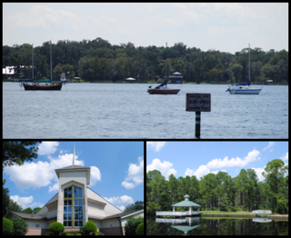
Ponte Vedra Beach is a wealthy unincorporated community and suburb of Jacksonville, Florida in St. Johns County, Florida, United States. Located 18 miles (29 km) southeast of downtown Jacksonville and 26 miles (42 km) north of St. Augustine, it is part of the Jacksonville Beaches area, and on the island nicknamed San Pablo Island.

<span class="mw-page-title-main">Florida State Road 202</span> Highway in Florida

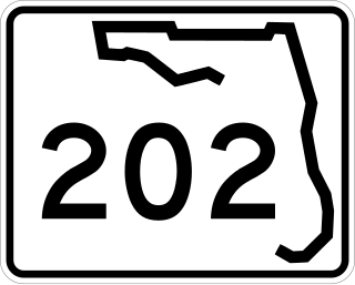
State Road 202 (SR 202) is a 13.042-mile-long (20.989 km) state highway that extends from U.S. Route 1, in Jacksonville, Florida to SR A1A, in Jacksonville Beach, near the Atlantic Ocean, just north of Ponte Vedra Beach, and includes a bridge over the Intracoastal Waterway. To locals, the road is better known as J. Turner Butler Boulevard, Butler Boulevard, or JTB. Despite being named as a boulevard, the road is a completely limited-access expressway, with the exception of the westernmost 0.5 miles between US 1 and Interstate 95 (I-95),. It was constructed in sections by the Jacksonville Transportation Authority. The first section opened in 1979, but the entire road was not completed until 1997.

<span class="mw-page-title-main">Palm Valley Bridge</span> Bridge in Florida, United States of America

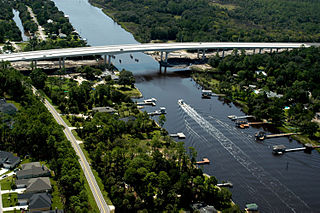
The Palm Valley Bridge spans the Intracoastal Waterway in the Palm Valley area near Ponte Vedra Beach, Florida. It is located on County Road 210 in St. Johns County. In 2002, the old two-lane drawbridge was replaced with a fixed, clear span, four-lane bridge. Ground-breaking was in December 2000 and the official ribbon cutting ceremony was held in July 2002. The Palm Valley Bridge was built due to increasing traffic on the bridge and population growth in the area.

<span class="mw-page-title-main">Pedro Menendez High School</span> Public school in St. Augustine, Florida, United States

Pedro Menendez High School is a public high school in the St. Johns County School District, located in southern St. Johns County, Florida, United States. It was named for Pedro Menéndez de Avilés, a sixteenth-century Spanish admiral and pirate hunter who founded St. Augustine, the first permanent European settlement and oldest port city in what is now the continental United States, on August 28, 1565.

Fleming Island is an unincorporated community and census-designated place (CDP) in Clay County, Florida, United States. It is located 21 miles (34 km) southwest of downtown Jacksonville, on the western side of the St. Johns River, off US 17. As of the 2020 census the Fleming Island CDP had a population of 29,142, up from 27,126 at the 2010 census. It is part of the Jacksonville, Florida Metropolitan Statistical Area. Fleming Island's ZIP code became 32003 in 2004, giving it a different code from Orange Park, the incorporated town to the north.

<span class="mw-page-title-main">Allen D. Nease High School</span> Public high school in Nocatee , Florida, United States

Allen D. Nease High School is a high school in the St. Johns County School District, located in the Nocatee census-designated place, in St. Johns County, Florida. It is a part of the St. Johns County School District.

<span class="mw-page-title-main">Nocatee, Florida</span> Planned community in Florida

Nocatee is an unincorporated planned community and census-designated place (CDP) located primarily in northern St. Johns County, Florida. The population was 22,503 at the 2020 census, up from 4,524 at the 2010 census, an increase of nearly 400%. It is part of the Jacksonville, Florida Metropolitan Statistical Area. As of 2020, the community consists of twenty-two neighborhoods, some of which are specialized for certain age groups. The community blends a variety of neighborhoods with schools, parks, recreation, offices, shopping, and restaurants. Part of the development lies within Jacksonville city limits in Duval County, although the CDP lies entirely within St. Johns County. It is near Ponte Vedra Beach in Florida's First Coast region and sits on 13,323 acres (5,392 ha) of land. It was approved in 2001 as a Development of Regional Impact (DRI) under Section 380.06 of the Florida Statutes.

<span class="mw-page-title-main">Ponte Vedra High School</span> Public school in Nocatee , Florida, United States

Ponte Vedra High School (PVHS) is a public high school in the St. Johns County School District, located in Nocatee census-designated place, northeast St. Johns County, Florida. The high school was constructed to relieve overcrowding at Allen D. Nease High School.

<span class="mw-page-title-main">Jacksonville Beaches</span> Region of Jacksonville in Florida

The Jacksonville Beaches, or Jax Beaches known locally as "The Beaches", are a group of towns and communities on the northern half of an unnamed barrier island on the US state of Florida's First Coast, all of which are excluded cities or parts of the city of Jacksonville itself. These communities are separated from the main body of the city of Jacksonville by the Intracoastal Waterway. The Jacksonville Beaches are located in Duval and northern St. Johns County counties, and make up part of the Jacksonville metropolitan area. The main communities generally identified as part of the Beaches are Mayport, Atlantic Beach, Neptune Beach, Jacksonville Beach, and Ponte Vedra Beach.

References

  1. "2020 U.S. Gazetteer Files". United States Census Bureau. Retrieved October 31, 2021.
  2. 1 2 "U.S. Census website". United States Census Bureau . Retrieved January 31, 2008.
  3. "US Board on Geographic Names". United States Geological Survey. October 25, 2007. Retrieved January 31, 2008.
  4. "Explore Census Data". data.census.gov. Retrieved May 16, 2024.
  5. "History". Archived from the original on February 25, 2010. Retrieved October 13, 2010.
  6. "US Gazetteer files: 2010, 2000, and 1990". United States Census Bureau. February 12, 2011. Retrieved April 23, 2011.
  7. "Sawgrass - Place Explorer - Data Commons". datacommons.org. Retrieved March 25, 2021.
  8. "U.S. Census Bureau QuickFacts: Palm Valley CDP, Florida". www.census.gov. Retrieved March 25, 2021.
  9. "Average Weather in Palm Valley, Florida, United States, Year Round - Weather Spark". weatherspark.com. Retrieved March 25, 2021.
  10. "Census of Population and Housing". Census.gov. Retrieved June 4, 2016.
  11. "American FactFinder - Results". Archived from the original on February 10, 2020. Retrieved April 6, 2009.
  12. "2020 CENSUS - CENSUS BLOCK MAP (INDEX): Palm Valley CDP, FL" (PDF). U.S. Census Bureau . Retrieved August 2, 2022.
  13. "2022 - 2023 St. Johns County School Attendance Zones PV-PV/Rawlings Elementary School" (PDF). St. Johns County School District. Archived from the original (PDF) on August 2, 2022. Retrieved August 2, 2022. - See index of maps
  14. "2022 - 2023 St. Johns County School Attendance Zones Ocean Palms Elementary School" (PDF). St. Johns County School District. Archived from the original (PDF) on August 2, 2022. Retrieved August 2, 2022. - See index of maps
  15. "2022 - 2023 St. Johns County School Attendance Zones Alice B. Landrum Middle School" (PDF). St. Johns County School District. Archived from the original (PDF) on August 2, 2022. Retrieved August 2, 2022. - See index of maps
  16. "2022 - 2023 St. Johns County School Attendance Zones Ponte Vedra High School" (PDF). St. Johns County School District. Archived from the original (PDF) on August 2, 2022. Retrieved August 2, 2022.
  17. "Ponte Vedra Beach". St. Johns County Public Library . Retrieved August 2, 2022. 101 Library Blvd. Ponte Vedra Beach, FL 32082