Tallahassee metropolitan area

Last updated
Tallahassee metropolitan area
Tallahassee, FL Metropolitan Statistical Area
Tallahassee—Bainbridge, FL-GA Combined Statistical Area
Old and New Florida State Capitol, Tallahassee, East view 20160711 1.jpg
Florida Capitol buildings (Old Capitol in foreground)
Tallahassee metropolitan area
Interactive Map of Tallahassee–Bainbridge, FL–GA CSA
Country United States
State(s) Florida
Georgia
Counties
Principal city Tallahassee
Other cities
Area
  MSA2,604 sq mi (6,750 km2)
  CSA3,227 sq mi (8,360 km2)
Population
 (2020)
  Total384,298
  Estimate 
(2023)
392,645
  CSA (2020)
413,665
  CSA (2023)
421,732
Time zone UTC-5 (EST)
  Summer (DST) UTC-4 (EDT)

The Tallahassee Metropolitan Area is the metropolitan area centered on Tallahassee, the capital of the U.S. state of Florida, located in Leon County the center of North Florida in the Florida panhandle.

Contents

The Tallahassee Metropolitan Statistical Area is a metropolitan statistical area (MSA) designated by the Office of Management and Budget and used by the Census Bureau and other agencies for statistical purposes. The Tallahassee Metropolitan Statistical Area consists of the following four Florida counties: Leon, Gadsden, Wakulla, and Jefferson.

The Tallahassee—Bainbridge, FL-GA Combined Statistical Area is a combined statistical area (CSA) is a primary statistical area that includes the Tallahassee, FL Metropolitan Statistical Area and the Bainbridge, GA Micropolitan Statistical Area (μSA), which is comprised solely of the Georgia county of Decatur.

Additionally, the Thomasville, GA μSA is immediately adjacent to the Tallahassee MSA to the northeast. The distance and driving time between the Thomasville and Tallahassee city centers during commuting hours is both five miles and 5-10 minutes shorter than those between the Bainbridge and Tallahassee city centers. [1] [2]

CountyPop. (2020) [3] Area (mi2)County Seat
Leon 292,198702 Tallahassee*
Gadsden 43,826529 Quincy
Wakulla 33,764736 Crawfordville
Jefferson 14,510637 Monticello
MSA384,2982,604
Decatur 29,367623 Bainbridge
CSA413,6653,227

*denotes principal city in the MSA

History

The Tallahassee Standard Metropolitan Statistical Area was first defined in 1965, and at that time included only Leon County. Wakulla County was added to the MSA in 1973. In 1983, Wakulla County was removed from the MSA and Gadsden County was added. Jefferson County and Wakulla County (for the second time) were added to the MSA in 2003. [4]

Geography

The counties of the Tallahassee Metropolitan Area cover an area of around 2,604 sq mi (6,750 km2), of which around 2,390 sq mi (6,1890 km2) is land. Much of that water area is in Wakulla and Jefferson counties along the coastline of Apalachee Bay. Only 141.33 sq mi (366.04 km2), or 5.92%, of the area is urbanized, with nearly 80% of said urban area belonging to the Tallahassee, FL Urban Area. [5]

Greater Tallahassee straddles the boundaries of the Red Hills Region, the Cody Scarp, and the Woodville Karst Plain. As such, the northern half of the metropolitan area, including much of the city of Tallahassee, is substantially more hilly than the rest of the state of Florida. The area also straddles four watersheds, from west to east: Apalachicola, Ochlockonee, St. Marks, and Aucilla. The latter three all drain into the Gulf of Mexico either within or at the edges of the metropolitan area, with the Ocholockonee and Aucilla Rivers forming parts of the western and eastern borders.

Also see Leon County Geology

All counties in both the Tallahassee MSA and CSA are in Eastern Time Zone, with the western border of Gadsden County with Jackson County forming the boundary with the Central Time Zone.

Demographics

Historical population
CensusPop.Note
1970 103,047
1980 159,54254.8%
1990 233,59846.4%
2000 284,53921.8%
2010 367,41329.1%
2020 384,2984.6%
2023 (est.)392,645 [6] 2.2%
U.S. Decennial Census [7]

1970: Only Leon
1980: Leon and Wakulla
1990-2000: Leon and Gadsden

2010-2023: Leon, Gadsden, Wakulla, Jefferson

As of the census [8] of 2000, there were 320,304 people, 125,533 households, and 75,306 families residing within the MSA. The racial makeup of the MSA was 63.59% White, 32.17% African American, and 1.39% from two or more races. 3.72% were Hispanic or Latino of any race.

The median income for a household in the MSA was $34,728, and the median income for a family was $42,957. Males had a median income of $29,628 versus $24,977 for females. The per capita income for the MSA was $17,552.

Places of Interest

Also see Tallahassee Places of interest and Arts and Culture.

National, State, and Local Protected Areas

Communities

The Tallahassee Metropolitan Area has contains eight incorporated cities and two incorporated towns, along with thirteen additional populated areas defined as a census-designated place (CDP) by the U.S. Census Bureau as of the 2020 census. The Combined Statistical Area has an additional three cities, one town, and one CDP. As of 2020, the city of Tallahassee contained 51% and 47% of the MSA and CSA populations, respectively.

#CityTypeCounty2020

population

1 Tallahassee*CityLeon196,169
2 Bradfordville CDPLeon19,183
3 Bainbridge*CityDecatur14,468
4 Quincy*CityGadsden7,970
5 Crawfordville*CDPWakulla4,853
6 Woodville CDPLeon4,097
7 Midway CityGadsden3,537
8 Chattahoochee CityGadsden2,955
9 Monticello*CityJefferson2,589
10 Havana TownGadsden1,753
11 Gretna CityGadsden1,357
12 Fort Braden CDPLeon1,045
13 Panacea CDPWakulla735
14 Greensboro TownGadsden461
15 Attapulgus CityDecatur454
16 Sopchoppy CityWakulla426
17 Miccosukee CDPLeon383
18 Wacissa CDPJefferson362
19 Chaires CDPLeon308
20 Climax CityDecatur276
21 St. Marks CityWakulla274
22 Waukeenah CDPJefferson259
23 Capitola CDPLeon247
24 Brinson TownDecatur217
25 Lloyd CDPJefferson187
26 Lamont CDPJefferson170
27 Faceville CDPDecatur136
28 Aucilla CDPJefferson103

*denotes largest city and county chair

See Also

Related Research Articles

<span class="mw-page-title-main">Franklin County, Florida</span> County in Florida, United States

Franklin County is a county along the Gulf of Mexico in the panhandle of the U.S. state of Florida. As of the 2020 census, the population was 12,451, making it the third-least populous county in Florida. The county seat is Apalachicola.

<span class="mw-page-title-main">Gadsden County, Florida</span> County in Florida, United States

Gadsden County is a county located in the panhandle of the U.S. state of Florida. As of the 2020 census, the population was 43,826. Its county seat is Quincy. Gadsden County is included in the Tallahassee, FL Metropolitan Statistical Area. Gadsden County is the only majority African-American county in Florida.

<span class="mw-page-title-main">Jefferson County, Florida</span> County in Florida, United States

Jefferson County is a county located in the Big Bend region in the northern part of the U.S. state of Florida. As of the 2020 census, the population was 14,510. Its county seat is Monticello.

<span class="mw-page-title-main">Leon County, Florida</span> County in Florida, United States

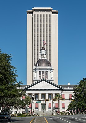
Leon County is a county in the Panhandle of the U.S. state of Florida. It was named after the Spanish explorer Juan Ponce de León. As of the 2020 census, the population was 292,198.

<span class="mw-page-title-main">Liberty County, Florida</span> County in Florida, United States

Liberty County is a county located in the state of Florida. As of the 2020 census, the population was 7,974, making it the least populous county in Florida. Its county seat is Bristol. Liberty County is the only dry county in Florida. Lafayette County prohibits bars, but not retail sale of beer.

<span class="mw-page-title-main">Wakulla County, Florida</span> County in Florida, United States

Wakulla County is a county located in the Big Bend region in the northern portion of the U.S. state of Florida. As of the 2020 census, the population was 33,764. Its county seat is Crawfordville.

<span class="mw-page-title-main">Thomas County, Georgia</span> County in Georgia, United States

Thomas County is a county located in the U.S. state of Georgia. As of the 2020 census the population was 45,798. The county seat is Thomasville. Thomas County comprises the Thomasville, GA micropolitan statistical area.

<span class="mw-page-title-main">Decatur County, Georgia</span> County in Georgia, United States

Decatur County is a county located in the U.S. state of Georgia. As of the 2020 census, the population was 29,367. The county seat is Bainbridge.

<span class="mw-page-title-main">Midway, Gadsden County, Florida</span> City in Florida, United States of America

Midway is a city in Gadsden County, Florida, United States. It is part of the Tallahassee, Florida Metropolitan Statistical Area. According to the 2020 census, the population was 3,537, up from 3,004 at the 2010 census.

<span class="mw-page-title-main">St. Marks, Florida</span> City in Florida, United States

St. Marks is a city in Wakulla County, Florida, United States. It is part of the Tallahassee, Florida Metropolitan Statistical Area. St. Marks is located on the Florida Panhandle in North Florida, along the Gulf of Mexico. The population at the 2020 census was 274, down from 293 at the 2010 census.

<span class="mw-page-title-main">Bainbridge, Georgia</span> City in Georgia, United States

Bainbridge is a city in Decatur County, Georgia, United States. The city is the county seat of Decatur County. As of the 2020 census, the city had a population of 14,468, up from 12,697 at the 2010 census. It is the principal city of the Bainbridge, Georgia Micropolitan Statistical Area and a principal city in the Tallahassee—Bainbridge, FL-GA Combined Statistical Area.

<span class="mw-page-title-main">Florida panhandle</span> Northwest region of Florida

The Florida panhandle is the northwestern part of the U.S. state of Florida. It is a salient roughly 200 miles (320 km) long, bordered by Alabama on the north and the west, Georgia on the north, and the Gulf of Mexico to the south. Its eastern boundary is arbitrarily defined. It is defined by its southern culture and rural geography relative to the rest of Florida, as well as closer cultural links to French-influenced Louisiana, Mississippi, and Alabama. Its major communities include Pensacola, Navarre, Destin, Panama City Beach, and Tallahassee.

<span class="mw-page-title-main">Ochlockonee River State Park</span> Preserve in Florida, USA

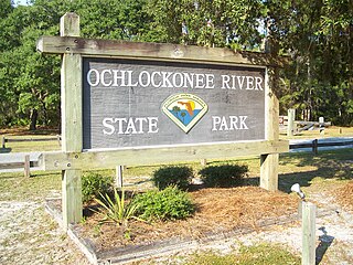
Ochlockonee River State Park is a Florida State Park located in Wakulla County, Florida, south of the town of Sopchoppy in the Florida Panhandle. Located off of U.S. 319 on the Ochlockonee River, just north of the Gulf of Mexico coast, it is surrounded by the Apalachicola National Forest and the St. Marks National Wildlife Refuge and provides important habitat for the endangered red-cockaded woodpecker.

<span class="mw-page-title-main">Florida State Road 267</span> State highway in Florida, United States

State Road 267 is a road in the U.S. state of Florida. It has a north–south state route in the eastern Florida panhandle, west of Tallahassee.

<span class="mw-page-title-main">Red Hills Region</span> Region of the southeastern United States

The Red Hills or Tallahassee Hills is a region of gently rolling hills in the southeastern United States. It is a geomorphic region and an ecoregion.

<span class="mw-page-title-main">Jacksonville metropolitan area</span> Metropolitan Statistical Area in the United States

The Jacksonville Metropolitan Area, also called the First Coast, Metro Jacksonville, or Northeast Florida, is the metropolitan area centered on the principal city of Jacksonville, Florida and including the First Coast of North Florida. As of the 2020 United States census, the total population was 1,605,848. The Jacksonville–Kingsland–Palatka, FL–GA Combined Statistical Area (CSA) had a population of 1,733,937 in 2020 and was the 34th largest CSA in the United States. The Jacksonville metropolitan area is the 40th largest in the country and the fourth largest in the State of Florida, behind the Miami, Tampa, and Orlando metropolitan areas.

<span class="mw-page-title-main">Ochlockonee River</span> River in Florida and Georgia, United States

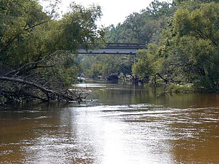
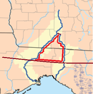
The Ochlockonee River is a fast running river, except where it has been dammed to form Lake Talquin in Florida, originating in Georgia and flowing for 206 miles (332 km) before terminating in Florida.

<span class="mw-page-title-main">Sarasota metropolitan area</span> Metropolitan area in Florida, United States

The Sarasota metropolitan area is a metropolitan area located in Southwest Florida. The metropolitan area is defined by the Office of Management and Budget (OMB) as the North Port–Bradenton–Sarasota Metropolitan Statistical Area, a metropolitan statistical area (MSA) consisting of Manatee County and Sarasota County. The principal cities listed by the OMB for the MSA are North Port, Bradenton, Sarasota, Lakewood Ranch, and Venice. At the 2020 census, the MSA had a population of 833,716. The Census Bureau estimates that its population was 891,411 in 2022.

<span class="mw-page-title-main">Big Bend (Florida)</span> Region of the state Florida, United States

The Big Bend of Florida, United States, is an informally named geographic region of North Florida where the Florida Panhandle transitions to the Florida Peninsula south and east of Tallahassee. The region is known for its vast woodlands and marshlands and its low population density relative to much of the state. The area is home to the largest single spring in the United States, the Alapaha Rise, and the longest surveyed underwater cave in the United States, the 32-mile (51 km) Wakulla-Leon Sinks cave system.

<span class="mw-page-title-main">Columbia metropolitan area, South Carolina</span> Combined Statistical Area in South Carolina, United States

As defined by the U.S. Office of Management and Budget, and used by the U.S. Census Bureau for statistical purposes only, the Columbia, SC Metropolitan Statistical Area, is an area consisting of six counties in central South Carolina, anchored by the city of Columbia. The current population has an estimation of 837,092. It is the second-largest metropolitan statistical area in the state of South Carolina, since the Anderson metropolitan statistical area was combined with Greenville's following the 2010 census.

References

  1. "Bainbridge to Florida State Capitol". Google Maps. May 16, 2024.
  2. "Thomasville to Florida State Capitol". Google Maps. May 16, 2024.
  3. "Explore Census Data". data.census.gov. Retrieved 2024-05-16.
  4. "Metro Area History 1950–2020". U.S. Census Bureau. March 2020. Row 4179. Retrieved July 27, 2023.
  5. Bureau, US Census. "Urban and Rural". Census.gov. Retrieved 2024-05-17.
  6. "Annual Estimates of the Resident Population for Counties: April 1, 2020 to July 1, 2023". United States Census Bureau. Retrieved March 31, 2024.
  7. "U.S. Decennial Census". United States Census Bureau. Retrieved June 14, 2014.
  8. "U.S. Census website". United States Census Bureau . Retrieved 2008-01-31.

30°18′N84°12′W / 30.3°N 84.2°W / 30.3; -84.2