Palmer Park is a regional park in Colorado Springs, Colorado. Located at 3650 Maizeland Road, the park is several miles northeast of the downtown area.[2]Elevation Outdoors Magazine named it Best Urban Park in its Best of Rockies 2017 list.[3] One of Best of the Springs Expert Picks - Sports & Recreation by The Gazette, Seth Boster states that it may have the city's best views of Pikes Peak and a place "where an escape into deep nature is easy. It is strange and marvelous to look out at urban sprawl while perched on some high rock ledge, surrounded by rugged wilderness."[4]
The area that is now Palmer Park was once owned by Matt France, the earliest recorded owner. In 1873, France sold his property to Henry Austin who used this property to raise sheep. The general area became known as Austin Bluffs.[5]
In 1902, William Jackson Palmer the founder of Colorado Springs, donated the 692 acres to Colorado Springs for the park.[6][7] It was one of many parks established due to land donations by Palmer. As reported in The New York Times in 1907, Palmer also provided the land for Monument Valley Park, North Cheyenne Cañon Park, and Dorchester Park.[8] Palmer donated the land for three formal parks in downtown Colorado Springs, including Alamo Square, Acacia Park, and Antlers Park. He improved the roads to the park, Paseo Drive and Palmer Park Boulevard.[9]
The area is now a Colorado Springs Regional Park, and the largest park inside of the metro area.[2]
One of the largest sheer sandstone bluff dropoffs, over 80' top to bottom
The park has a variety of geologic formations, including tall rock spires or hoodoos and steep cliffs, as well as open fields. Scenic overlooks include views of Pikes Peak.[10] Within the park is a geological point of interest, Seven Castles, and a botanical reserve[2] for yucca plants.[11] Paseo Drive runs through the park to the horse stables.[12]
Pikes Peak as seen from Palmer Park at dusk. The high elevation of Palmer Park relative to the city of Colorado Springs provides many long distance vistas
At 730.7 acres in size, the park contains over 25 miles of trails for horseback riding, mountain biking, and hiking.[2] On the mesa overlooking the city,[11] are interconnected trails are generally single track, but there are also doubletrack trails and dirt road trails. The terrain is rocky and hard-packed dirt.[12] One of the trails is the Edna Mae Bennet Nature trail,[11] a 2.6 miles (4.2km) trail in the rocky bluffs of the park with views of ravines, canyons, and rock formations.[13] Other noted trails are Templeton Trail and Yucca Flats.[4] There is a dog run, like Bear Creek Dog Park.[14] The park has a dog park, two baseball/softball fields, a football/soccer field, three volleyball courts, a community playground, horse stables, and several picnic grounds.[2]
Colorado Springs is a home rule municipality that is the largest city by area in Colorado as well as the county seat and the most populous municipality of El Paso County, Colorado, United States. It is in east central Colorado, on Fountain Creek, 60 miles (97 km) south of Denver. At 6,035 feet (1,839 m) the city stands over 1 mile (1.6 km) above sea level, though some areas are significantly higher and lower. Colorado Springs is near the base of Pikes Peak, which rises 14,115 feet (4,302 m) above sea level on the eastern edge of the Southern Rocky Mountains.
Garden of the Gods is a public park located in Colorado Springs, Colorado, United States. It was designated a National Natural Landmark in 1971.
Comanche National Grassland is a National Grassland located in southeastern Colorado, United States. It is the sister grassland of Cimarron National Grassland and contains both prairie grasslands and canyons. It is separated into two sections, each operated by a local ranger district, one of which is in Springfield and the other of which is in La Junta. The grassland is administered by the Forest Service together with the Pike and San Isabel National Forests, and the Cimarron National Grassland, from common headquarters located in Pueblo, Colorado.
The Broadmoor Seven Falls is a series of seven cascading waterfalls of South Cheyenne Creek in South Cheyenne Cañon, Colorado Springs, Colorado. It has been a privately-owned tourist attraction since it was opened in the early 1880s.
Old Colorado City, formerly Colorado City, was once a town, but it is now a neighborhood within the city of Colorado Springs, Colorado. Its commercial district was listed on the National Register of Historic Places in 1982. It was founded during the Pikes Peak Gold Rush of 1859 and was involved in the mining industry, both as a supply hub and as a gold ore processing center beginning in the 1890s. Residents of Colorado City worked at some of the 50 coal mines of the Colorado Springs area. It was briefly the capital of the Colorado Territory. For many years, Colorado Springs prohibited the use of alcohol within its border due to the lifestyle of Colorado City's opium dens, bordellos, and saloons. It is now a tourist area, with boutiques, art galleries, and restaurants.
Before it was founded, the site of modern-day Colorado Springs, Colorado, was part of the American frontier. Old Colorado City, built in 1858 during the Pike's Peak Gold Rush was the Colorado Territory capital. The town of Colorado Springs, was founded by General William Jackson Palmer as a resort town. Old Colorado City was annexed into Colorado Springs. Railroads brought tourists and visitors to the area from other parts of the United States and abroad. The city was noted for junctions for seven railways: Denver and Rio Grande (1870), Denver and New Orleans Manitou Branch (1882), Colorado Midland (1886-1918), Colorado Springs and Interurban, Atchison, Topeka, and Santa Fe (1889), Rock Island (1889), and Colorado Springs and Cripple Creek Railways. It was also known for mining exchanges and brokers for the Cripple Creek Gold Rush.
Austin Bluffs is a summit in the Pikeview area of Colorado Springs in El Paso County, Colorado at 6,673 feet (2,034 m) in elevation. It is also a residential area, that was once a settlement and the site of a tuberculosis sanatorium. The University of Colorado Colorado Springs campus was moved there in 1965.
Colorado Springs geography describes geographical topics regarding the city of Colorado Springs, Colorado in El Paso County, Colorado. With 194.87 sq mi (504.7 km2) of land, it is the state's largest-sized city. Denver is the most populated city.
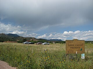
Aiken Canyon Preserve is a 1,621-acre (6.56 km2) Nature Conservancy-managed state property in Colorado. It was first observed and named after Charles Aiken who was a 19th century U.S. surveyor, pioneer and ornithologist who first surveyed Aiken Canyon in the 1870s and identified more than 75 bird species. The preserve consists of foothills, shrub and woodland ecosystems and is 12.4 miles southeast from Colorado Springs located on the eastern slope of the Rampart Range which is within a smaller foothill system of the Front Range. The surrounding mountain ranges of the Rampart Range and Palmer Divide created the nature preserves sustainable ecosystem. There is also a four-mile (6 km)-loop hiking trail on the preserve.
The Pequot Trail is a 7.6-mile (12.2 km) Blue-Blazed Trail, a hiking trail maintained by the Connecticut Forest and Park Association.
Manitou Bathhouse or Manitou Spa is a historic building located along Fountain Creek in Manitou Springs, Colorado. Once used as a mineral water bathhouse or spa, the building is now used for stores and other businesses on the first floor. The second and third floors hold residential units. It is on the National Register of Historic Places. Located in the building is Adam's Mountain Cafe.
North Cheyenne Cañon Park or North Cheyenne Canyon Park is a regional park located in Colorado Springs, Colorado. It is a National Register of Historic Places listing.
There are a wide range of recreational areas and facilities in Colorado Springs, Colorado.
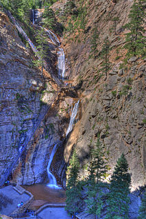
Silver Cascade Falls is a waterfall located on St. Mary's Creek in the North Cheyenne Cañon Park of Colorado Springs, Colorado.
Englemann Canyon is a valley along Ruxton Creek, in Manitou Springs, El Paso County, Colorado. It is one of three canyons in Manitou Springs, the others are Ute Pass and Williams Canyon.
South Cheyenne Cañon, or South Cheyenne Canyon, is a canyon in Colorado Springs, El Paso County, Colorado. The South Cheyenne Cañon road to Seven Falls is called "The Grandest Mile of Scenery" in Colorado. Seven Falls has been a tourist attraction since it was opened in the early 1880s. Trails from the top of the falls lead to Midnight Falls, near the headwaters of South Cheyenne Creek, and Inspiration Point. The area has been a center for parks, such as the Stratton Park and Colorado College Park. Now, part of South Cheyenne Cañon, including the Starsmore Discovery Center, is in the North Cheyenne Cañon Park. The area sustained a significant flood in September 2013, which has closed Seven Falls until Spring 2015.
The Manitou Park Recreation Area is a recreation area in the Pike National Forest, located 5.2 miles (8.4 km) north of Woodland Park along Colorado State Highway 67 in Teller County, Colorado. The recreation area includes several campgrounds and a picnic area, the Manitou Lake Picnic Area.
Cheyenne Mountain is a triple-peaked mountain in El Paso County, Colorado, southwest of downtown Colorado Springs. The mountain serves as a host for military, communications, recreational, and residential functions. The underground operations center for the North American Aerospace Defense Command (NORAD) was built during the Cold War to monitor North American airspace for missile launches and Soviet military aircraft. Built deep within granite, it was designed to withstand the impact and fallout from a nuclear bomb. Its function broadened with the end of the Cold War, and then many of its functions were transferred to Peterson Air Force Base in 2006.
Bierstadt Lake is located in Larimer County, Colorado and within the Rocky Mountain National Park. Near McHenrys Peak and Longs Peak, there are "spectacular views" of the Continental Divide at the lake. The Bierstadt Lake Trailhead is located about 6.5 miles (10.5 km) from the turn-off at U.S. Route 36 into the Rocky Mountain National Park. During the summer, shuttle buses provide transportation to the trailhead.
Alice Stewart Hill was an American artist who created paintings and illustrations. Her specialty was creating works of art based upon the flowers of Colorado. Her work was of interest to noted botanist Asa Gray of Harvard College because Colorado has flowers that were different than their eastern varieties, as well as flowers that grow above the timberline on Pikes Peak.
This page is based on this Wikipedia article Text is available under the CC BY-SA 4.0 license; additional terms may apply. Images, videos and audio are available under their respective licenses.