Stirling is a city in central Scotland, 26 miles (42 km) northeast of Glasgow and 37 miles (60 km) north-west of Edinburgh. The market town, surrounded by rich farmland, grew up connecting the royal citadel, the medieval old town with its merchants and tradesmen, the Old Bridge and the port. Located on the River Forth, Stirling is the administrative centre for the Stirling council area, and is traditionally the county town of Stirlingshire. Proverbially it is the strategically important "Gateway to the Highlands".
Robert Haldane was a religious writer and Scottish theologian. Author of Commentaire sur l'Épître aux Romains, On the Inspiration of Scripture and Exposition of the Epistle to the Romans.
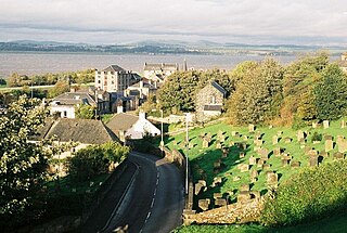
Borrowstounness is a town and former burgh and seaport on the south bank of the Firth of Forth in the Central Lowlands of Scotland. Historically part of the county of West Lothian, it is a place within the Falkirk council area, 17 miles northwest of Edinburgh and 6+3⁄4 miles east of Falkirk. At the 2011 United Kingdom census, the population of the Bo'ness locality was 15,100.

Crail ; Scottish Gaelic: Cathair Aile) is a former royal burgh, parish and community council area in the East Neuk of Fife, Scotland.

Stirlingshire or the County of Stirling is a historic county and registration county of Scotland. Its county town is Stirling.

The Stirling council area is one of the 32 council areas of Scotland, and has a population of about 93,470. It was created in 1975 as a lower-tier district within the Central region. The district covered parts of the historic counties of Stirlingshire and Perthshire, which were abolished for local government purposes. In 1996 the Central region was abolished and Stirling Council took over all local government functions within the area.

Prestwick is a town in South Ayrshire on the west coast of Ayrshire in Scotland about 30 miles southwest of Glasgow. It adjoins the larger town of Ayr to the south on the Firth of Clyde coast, the centre of which is about two miles south, and the small village of Monkton to the north. It had a population of 14,901 at the 2011 census.
Giffnock is a town and the administrative centre of East Renfrewshire in the Central Lowlands of Scotland.
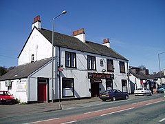
Stenhousemuir is a town in the Central Lowlands of Scotland. It lies within the Falkirk council area of Scotland. The town is 2 miles north-northwest of Falkirk and directly adjoins to Larbert in the west, where the nearest rail access is located. The villages of Carron and Carronshore adjoin Stenhousemuir to the east but to a lesser extent. At the 2001 census it showed that it had a resident population of 10,351 but according to a 2009 estimate this was revised to around 10,190 residents. The combined population of the four localities in 2011 was 24,722, representing about 15% of the Falkirk council area total.

Pollokshields is an area in the Southside of Glasgow, Scotland. Its modern boundaries are largely man-made, being formed by the M77 motorway to the west and northwest with the open land of Pollok Country Park and the Dumbreck neighbourhood beyond, by the Inverclyde Line railway and other branches which separate its territory from the largely industrial areas of Kinning Park, Kingston and Port Eglinton, and by the Glasgow South Western Line running from the east to south, bordering Govanhill, Strathbungo, Crossmyloof and Shawlands residential areas. There is also a suburban railway running through the area.

Faifley is a large estate forming part of the town of Clydebank, Scotland, adjoining the former village of Hardgate, with a population of approximately 5,001. Along with Duntocher and Hardgate, Faifley falls within West Dunbartonshire's Kilpatrick ward with a combined population of 12,719 in 2011.

The Royal Burgh of Haddington is a town in East Lothian, Scotland. It is the main administrative, cultural and geographical centre for East Lothian. It lies about 17 miles east of Edinburgh. The name Haddington is Anglo-Saxon, dating from the sixth or seventh century AD when the area was incorporated into the kingdom of Bernicia. The town, like the rest of the Lothian region, was ceded by King Edgar of England and became part of Scotland in the tenth century. Haddington received Burgh status, one of the earliest to do so, during the reign of David I (1124–1153), giving it trading rights which encouraged its growth into a market town.

Stirling is a county constituency of the House of Commons of the Parliament of the United Kingdom. It elects one Member of Parliament (MP) by the first past the post system of election.

Linlithgow is a town in West Lothian, Scotland. It was historically West Lothian's county town, reflected in the county's historical name of Linlithgowshire. An ancient town, it lies in the Central Belt on a historic route between Edinburgh and Falkirk beside Linlithgow Loch. The town is situated approximately 20 miles (32 km) west of Edinburgh.

The Church of the Holy Rude is the medieval parish church of Stirling, Scotland. It is named after the Holy Rood, a relic of the True Cross on which Jesus was crucified. The church was founded in 1129 during the reign of David I, but the earliest part of the present church dates from the 15th century. As such it is the second oldest building in Stirling after Stirling Castle, parts of which date from the later 14th century. The chancel and tower were added in the 16th century.

Clan Stirling is a Scottish clan of the Scottish Lowlands.

Clan Haldane is a Lowland Scottish clan.
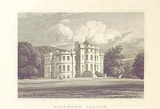
Airthrey Castle is a historic building and estate which now forms part of the buildings and grounds of the University of Stirling in central Scotland. The 18th-century building with 19th-century additions occupies a beautiful setting in landscaped grounds in the southern edge of the Ochil Hills, above the Forth valley. It is located close to Bridge of Allan, two miles from the historic city of Stirling.
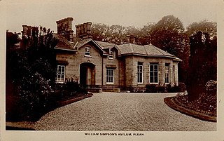
The William Simpson's Home is a care home in Plean, Scotland. It provides care for members of the armed services who have developed mental health or alcohol related problems.
Wallace ThorneycroftFRSE MIME MISI JP (1864–1954) was a 19th/20th century British mining engineer, businessman, coal-mine owner and geologist. He was President of the Institute of Mining Engineers. As a geologist and archaeologist he was an expert on vitrified forts and one of the first to undertake practical experiments to establish their mode of construction.