The village lies at the north-eastern edge of the Lake, at the junction of the A81 road with the B8034 road, which runs south, just to the west of Flanders Moss, to meet the A811 road at Arnprior. The elevation is around 25m (82ft) above sea level. The country around is generally low-lying, except to the north where the Menteith Hills rise, including Beinn Dearg (426m), with the Trossachs and the southern Highlands beyond. The Parish includes the outlying settlements of Cobleland, Dykehead, Gartmore and Ruskie.
The parish of Port of Menteith, with an area of 7,226 hectares (17,856 acres), had a resident population of 768 in the United Kingdom Census 2001, down from 884 in 1991.[1]
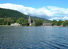
In the summer months a ferry runs from Port of Menteith to the island of Inchmahome, site of the Historic Scotland-maintained Inchmahome Priory. The village is home to a fishing club and is the starting point for anglers on the Lake of Menteith. Nick Nairn's cookery school is based at Loch End, just south of Port of Menteith at the south-east corner of the Lake.
Nearby Rednock House, the home of retired IndyCar champion Dario Franchitti, is a historic Laird's House remodelled by the architect Robert Brown of Edinburgh in 1827. Its grounds include a walled garden, ice house and ornamental water garden.
Aberfoyle is a village in the historic county and registration county of Perthshire and the council area of Stirling, Scotland. The settlement lies 27 miles northwest of Glasgow.
Loch is the Scottish Gaelic, Scots and Irish word for a lake or sea inlet. It is cognate with the Manx lough, Cornish logh, and one of the Welsh words for lake, llwch.
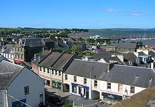
Stranraer, also known as The Toon, is a town in Dumfries and Galloway, Scotland. It is located in the historical parish of Inch in the historic county of Wigtownshire. It lies on the shores of Loch Ryan, on the northern side of the isthmus joining the Rhins of Galloway to the mainland. Stranraer is Dumfries and Galloway's second-largest town, with a population including the immediate surrounding area of nearly 13,000 inhabitants.
Gairloch is a village, civil parish and community on the shores of Loch Gairloch in Wester Ross, in the North-West Highlands of Scotland. A tourist destination in the summer months, Gairloch has a golf course, a museum, several hotels, a variety of shops, takeaway restaurants, a community centre, a leisure centre with sports facilities, a local radio station, beaches and nearby mountains. Gairloch is one of the principal villages on the North Coast 500 route.
Sutherland is a historic county, registration county and lieutenancy area in the Highlands of Scotland. Its county town is Dornoch. Sutherland borders Caithness and Moray Firth to the east, Ross-shire and Cromartyshire to the south and the Atlantic to the north and west. Like its southern neighbour Ross-shire, Sutherland has some of the most dramatic scenery in the whole of Europe, especially on its western fringe where the mountains meet the sea. These include high sea cliffs, and very old mountains composed of Precambrian and Cambrian rocks.
Menteith or Monteith, a district of south Perthshire, Scotland, roughly comprises the territory between the Teith and the Forth. Earlier forms of its name include Meneted, Maneteth and Meneteth.
Wigtownshire or the County of Wigtown is a historic county, registration county and lieutenancy area in south-west Scotland. It is popularly known as and referred to as The Shire. Until 1975, Wigtownshire was one of the administrative counties used for local government purposes, and is now administered as part of the council area of Dumfries and Galloway. As a lieutenancy area, Wigtownshire has its own Lord Lieutenant, currently John Alexander Ross. In the 19th century, it was also called West Galloway. The county town was historically Wigtown, with the administrative centre moving to Stranraer, the largest town, on the creation of a county council in 1890.
The Stirling council area is one of the 32 council areas of Scotland, and has a population of about 94,330. It was created under the Local Government etc (Scotland) Act 1994 with the boundaries of the Stirling district of the former Central local government region, and it covers most of Stirlingshire and the south-western portion of Perthshire. Both counties were abolished for local government purposes under the Local Government (Scotland) Act 1973.
Knapdale forms a rural district of Argyll and Bute in the Scottish Highlands, adjoining Kintyre to the south, and divided from the rest of Argyll to the north by the Crinan Canal. It includes two parishes, North Knapdale and South Knapdale. The area is bounded by sea to the east and west, whilst the sea loch of West Loch Tarbert almost completely cuts off the area from Kintyre to the south. The name is derived from two Gaelic elements: Cnap meaning hill and Dall meaning field.
Lake of Menteith, also known as Loch Inchmahome, is a loch in Scotland located on the Carse of Stirling.
Ardrishaig is a coastal village on Loch Gilp, at the southern (eastern) entrance to the Crinan Canal in Argyll and Bute in the west of Scotland. It lies immediately to the south of Lochgilphead, with the nearest larger town being Oban.
The Trossachs generally refers to an area of wooded glens, braes, and lochs lying to the east of Ben Lomond in the Stirling council area of Scotland. The name is taken from that of a small woodland glen that lies at the centre of the area, but is now generally applied to the wider region.
Drumnadrochit is a village in the Highland local government council area of Scotland, lying on the west shore of Loch Ness at the foot of Glen Urquhart. The village is contiguous with several neighbouring settlements, adjoining the villages of Milton to the west, Kilmore to the east and Lewiston to the south. The villages act as a centre for regional tourism beside Loch Ness, as well as being a local economic hub for the nearby communities.
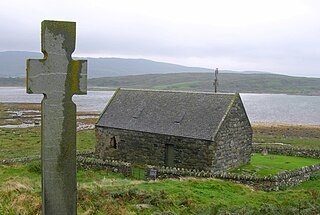
Inchmahome Priory is situated on Inchmahome, the largest of three islands in the centre of the Lake of Menteith, close to Aberfoyle, Scotland.
Loch Tummel is a long, narrow loch, 7 km (4.3 mi) north west of Pitlochry in the council area of Perth and Kinross, Scotland. It is fed and drained by the River Tummel, which flows into the River Tay about 13 km (8.1 mi) south-east of the Clunie Dam at the loch's eastern end.
Killin (; is a village situated at the western head of Loch Tay in the central highlands of Scotland. The village is administered by the Stirling council area but is more closely tied to the historic county of Perthshire, Scotland. Killin is a historic conservation village and sits within the Loch Lomond and The Trossachs National Park.
Lecropt is a rural parish lying to the west of Bridge of Allan, Scotland.
Sorbie is a small village in Wigtownshire, Machars, within the Administration area of Dumfries and Galloway Council, Scotland.
Arnprior is a hamlet in the Stirling council area of Scotland on the A811 about 12 miles west of Stirling and is one of the smallest community council districts in the region. The hamlet is next to the Flanders Moss National Nature Reserve and close to the east boundary of the Loch Lomond and Trossachs National Park, which includes the Lake of Menteith.
Heasta, Heast, or the anglicised form Heaste, pron. /heɪst/, is a small settlement on the island of Skye, Scotland. It is located on the west coast of the island five miles south of Broadford extending down to the north shore of Loch Eiseort, facing out to the Atlantic to the south west and is in the Scottish council area of Highland.
This page is based on this Wikipedia article Text is available under the CC BY-SA 4.0 license; additional terms may apply. Images, videos and audio are available under their respective licenses.