The Posey and Webster Street Tubes are two parallel underwater tunnels connecting the cities of Oakland and Alameda, California, running beneath the Oakland Estuary. Both are immersed tubes, constructed by sinking precast concrete segments to a trench in the Estuary floor, then sealing them together to create a tunnel. The Posey Tube, completed in 1928, currently carries one-way (Oakland-bound) traffic under the Estuary, while the Webster Street Tube, completed in 1963, carries traffic from Oakland to Alameda.
The Posey Tube is the second-oldest underwater vehicular tunnel in the US, preceded only by the Holland Tunnel. It is the oldest immersed tube vehicular tunnel in the world.
Both the Webster and Alice bridges were replaced by new swing bridges completed in 1900 and 1898, respectively. The Alice bridge was replaced by the Harrison Street bridge, one block west.[6] The replacements were prompted by the Secretary of War, who stated the swing spans each needed to be at least 150 feet (46m) to accommodate marine traffic in 1896. At first, it was planned to replace both bridges with a single bridge,[7] but Southern Pacific officials were unable to come to an agreement with Alameda County supervisors, and in 1897 the railroad declared the Harrison Street bridge, replacing the Alice bridge, would be devoted solely to rail traffic, accommodating both narrow and standard-gauge trains.[8] During the construction of the replacement Webster bridge, county supervisors initially rejected an offer to use the old Alice bridge as a detour for road traffic,[9] but later accepted, avoiding a more distant route through the eastern part of Alameda,[10] and teamster traffic moved to Alice in December.[11] The old Webster bridge was demolished by January 1899.[12]
By 1916, the War Department had declared the replacement Webster and Harrison bridges[13] were a menace to deep-water navigation and an obstacle to continued development of Oakland Harbor in 1916.[14] As an example, SSLancaster rammed the Webster Street bridge in January 1926, causing the swing section to fall into the Estuary and forcing road traffic to be rerouted.[15][16] After the completion of the Posey Tube, the Webster Street bridge was sold to Sacramento County for US$3,100(equivalent to $50,000 in 2022) in November 1928.[17] The central swing span was subsequently floated by barge up the Delta and reassembled as part of the new American River Bridge, later known as the Jibboom Street Bridge.[18]
Posey Tube
Posey Tube entrance in Alameda
Preliminary plans for a tube had been explored as early as 1903, but detailed studies were not prepared until 1922.[19] However, the entry of the United States into World War I delayed the plans for a new connection between Oakland and Alameda.[14] A permit for the tube under the Oakland Estuary was granted in April 1923[20] and Alameda County voters approved a $5million bond measure in May to build the tube.[21]
After the passage of the bond issue, test borings were taken in the Estuary, and bids were received for the work on March 23, 1925; the construction contract was awarded to the California Bridge and Tunnel Company (CB&TC) with a low bid of US$3,882,958(equivalent to $64,790,000 in 2022), and excavation started from the Oakland end on June 15, 1925. The contract was let by Alameda County without state involvement.[14]
The Posey Tube, completed and opened to traffic on October 27, 1928, was named after George Posey,[22] who was the Alameda County Surveyor during the tunnel's planning and construction, and also chief engineer on the construction project.[23][24] It is the first tunnel for road traffic built using the immersed tube technique.[25]:268 However, the two-lane tube was considered inadequate shortly after completion; in a 1952 letter from Frank Osborne, mayor of Alameda, to Lloyd Harmon, mayor of Coronado, which was considering a similar tunnel to San Diego, Osborne stated "from the time it was completed the tube was never adequate for the purpose for which it was built ... I am firmly of the belief that the building of any underwater tube of less than four lanes—two in each direction—would be a serious mistake on the part of any engineers who contemplate it." In 1952, the Posey Tube was handling 30,000 to 36,000 cars per day.[26]
Design
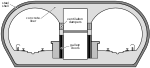
The ventilation buildings that house the exhaust and fresh air fans are built in an art deco style;[27] local architect Henry H. Meyers is credited with the design of both portals.[28] The design of the ventilation system to handle toxic vehicular exhaust fumes was modeled on that of the Holland Tunnel's ventilation system, and Ole Singstad (who had designed the pioneering ventilation system of the Holland Tunnel) consulted.[29] A pair of canaries were used during construction as living air monitors; although one canary died during construction, it was an accident caused by being penned up with a pet cat and not a toxic atmosphere.[30] Up to that time, tunnels had been vented longitudinally, with fresh air blown in one end and out the other; the Holland (and Posey) Tube instead used fans to supply air into the tunnel through a space beneath the roadway, and exhausted air through a similar space above the traffic portion. Ducts were set in the curb and ceiling approximately every 15 feet (4.6m) along the length of the Posey Tube, providing a system of "transverse" ventilation, bottom-to-top rather than end-to-end, ensuring that any fires would not spread through the length of the tunnel.[31]
Typical section of Webster Street Tube; Posey Tube sections are similar.
It was the first precast concrete tube to be constructed, assembled from 12 large segments. The concrete tube was protected from leaks through insulation and coverings applied to the outer surface.[31] Each segment was cast at Hunters Point by CB&TC. After they were completed, the segments were sealed and the space beneath the roadway was filled with water as ballast while floating each segment into position; when ready, wet sand was added to the roadway to sink the segment into a dredged underwater trench. Once the joint to the prior segment had been sealed, the water ballast was pumped out and the process was repeated for the next segment.[32]
Including the approaches at each end, the Posey Tube is 4,436 feet (1,352m) long;[24][33] the tunnel portion itself is 3,545 feet (1,081m) long.[32] Each segment is 203 feet (62m) long and 37 feet (11m) in diameter, and weighs approximately 5,000 short tons (4,500t).[32] The walls of the tube are 2+1⁄2 feet (0.76m) thick.[14] From Oakland, the approach extends from Sixth Street to Third Street along Harrison Street.[32] The maximum grade within the Posey Tube is 4.59%.[14]
Webster Street Tube
Webster Street Tube entrance in Oakland
The Webster Street Tube was constructed west of and parallel to the Posey Tube to accommodate increased traffic between Oakland and Alameda and to address the deficiencies of the original design, a single tube with only two lanes. In 1941, "final negotiations" were being made for a second tube,[34] and plans for a second tube at Webster Street had been advanced in 1948 as part of a Parallel Bridge scheme. The Parallel Bridge was one of the "Southern Crossing" designs which would have added another trans-Bay bridge south of the 1936 San Francisco–Oakland Bay Bridge.[35]
Construction began on October 12, 1959.[36] To prepare the Alameda site, a large Navy hangar was moved; at the time, it set a record for the largest building ever moved.[37] The Webster Street Tube was completed and opened to one-way (into Alameda) traffic in 1963.[38] Upon completion of the Webster Street Tube, the Posey Tube was closed temporarily and renovations were performed to convert it to one-way (into Oakland) traffic; during renovations, the Webster Street Tube handled bidirectional traffic.[39]
Like the preceding Posey Tube, the Webster Street Tube was constructed using immersed precast concrete segments; this time the twelve Webster segments were constructed in a graving dock built on Alameda. Divers were used to ensure each segment landed in the surveyed location. Piles were driven to support each segment, but the piles were designed to collapse after an additional 600 short tons (540t) of ballast were added, to ensure the segments rested firmly on a bed of packed sand. Construction of the Webster Street Tube started from the Alameda end and progressed towards Oakland, with the precast segments set before additional cast-in-place segments were added at each end.[36]
Each of the Webster segments were of comparable size and configuration to the earlier Posey Tube segments, measuring 200 feet (61m) long and 37 feet (11m) in diameter, with walls 2+1⁄2 feet (0.76m) thick.[36] However, the Webster segments were equipped with rectangular collars 45ft ×43ft (14m ×13m) (W×H) at each end, and weighed more, approximately 5,700 short tons (5,200t) each.[40] The roadway within the Webster Street Tube is 24 feet (7.3m) wide, and the minimum vertical clearance is 15ft 1+3⁄8in (4.607m).[36] Including approaches, the Webster Street Tube is 5,923 feet (1,805m) long,[39] of which 3,350 feet (1,020m) are underwater.[41]
A novel fluorescent continuous-line lighting system was designed for the Webster Street Tube.[42] Fresh air is supplied through the lower lunette space beneath the roadway, and exhaust is drawn through the upper lunette space above the tube's false ceiling. Each portal building contains four blowers and four exhaust fans, and they are capable of providing nearly 1,000,000cuft/min (470m3/s) of airflow in total.[36] Nearly the entire interior surface of the Webster Street Tube is tiled.[43]
The Webster Street Tube project cost more than $20million in total,[41][44] including renovations to the older Posey Tube; the construction contract for Webster was US$17,363,000(equivalent to $165,970,000 in 2022) alone.[41]
Alameda is a city in Alameda County, California, United States, located in the East Bay region of the Bay Area. The city is primarily located on Alameda Island, but also spans Bay Farm Island and Coast Guard Island, as well as a few other smaller islands in San Francisco Bay. As of the 2020 census, the city's population was 78,280.
The San Francisco–Oakland Bay Bridge, known locally as the Bay Bridge, is a complex of bridges spanning San Francisco Bay in California. As part of Interstate 80 and the direct road between San Francisco and Oakland, it carries about 260,000 vehicles a day on its two decks. It has one of the longest spans in the United States.
Interstate 580 (I-580) is an approximately 76-mile-long (122 km) east–west auxiliary Interstate Highway in Northern California. The heavily traveled spur route of I-80 runs from US Route 101 (US 101) in San Rafael in the San Francisco Bay Area to I-5 at a point outside the southern city limits of Tracy in the Central Valley. I-580 forms a concurrency with I-80 between Albany and Oakland, the latter of which is the location of the MacArthur Maze interchange immediately east of the San Francisco–Oakland Bay Bridge. I-580 provides a connection from the Bay Area to the southern San Joaquin Valley and Southern California via I-5, as I-5 bypasses the Bay Area to the east.
The Bayshore Freeway is a part of U.S. Route 101 in the San Francisco Bay Area of the U.S. state of California. It runs along the west shore of the San Francisco Bay, connecting San Jose with San Francisco. Within the city of San Francisco, the freeway is also known as James Lick Freeway, named after the California philanthropist. The road was originally built as a surface road, the Bayshore Highway, and later upgraded to freeway standards. Before 1964, it was mostly marked as U.S. Route 101 Bypass, with US 101 using the present State Route 82.
The Richmond–San Rafael Bridge is the northernmost of the east–west crossings of the San Francisco Bay in California, USA. Officially named after California State Senator John F. McCarthy, it bridges Interstate 580 from Richmond on the east to San Rafael on the west. It opened in 1956, replacing ferry service by the Richmond–San Rafael Ferry Company.
The Caldecott Tunnel is an east–west highway tunnel through the Berkeley Hills between Oakland and Orinda, California. Its four bores carry California State Route 24. Named after Thomas E. Caldecott, former mayor of Berkeley, it opened in 1937 as a two-bore tunnel. The third bore opened in 1964 and the fourth bore in 2013. Currently, the two oldest bores carry eastbound traffic and the two newest bores carry westbound traffic.
The Port of Oakland is a major container ship facility located in Oakland, California, in the San Francisco Bay. It was the first major port on the Pacific Coast of the United States to build terminals for container ships. As of 2011 it was the fifth busiest container port in the United States, behind Long Beach, Los Angeles, Newark, and Savannah. Development of an intermodal container handling system in 2002 after over a decade of planning and construction positions the Port of Oakland for further expansion of the West Coast freight market share. In 2019 it ranked 8th in the United States in the category of containers.
State Route 61 is a state highway in the U.S. state of California, running along the eastern edge of Oakland International Airport and through Alameda. Two additional "hidden" state highways, State Route 112 and State Route 260, are also signed as part of SR 61, despite having legal descriptions separate from Route 61.
State Route 75 (SR 75) is a 13-mile (21 km) north-south state highway in San Diego County, California. It is a loop route of Interstate 5 (I-5) that begins near Imperial Beach, heading west on Palm Avenue. The route continues north along the Silver Strand, a thin strip of land between the Pacific Ocean and San Diego Bay, through Silver Strand State Beach. SR 75 then passes through the city of Coronado as Orange Avenue and continues onto the San Diego–Coronado Bay Bridge, which traverses the bay, before joining back with I-5 near downtown San Diego.
State Route 17 is a state highway in the U.S. state of California that runs from State Route 1 in Santa Cruz to I-280 and I-880 in San Jose. SR 17, a freeway and expressway, carries substantial commuter and vacation traffic through the Santa Cruz Mountains at Patchen Pass between Santa Cruz and the San Francisco Bay Area.
State Route 282 (SR 282) is an east–west state highway entirely within the city of Coronado, California. It is a spur of SR 75 and connects the rest of the state highway system with Naval Air Station North Island. The road is part of a link connecting to the metropolitan area of San Diego via SR 75 and the Coronado Bay Bridge. The entire route uses a one-way couplet, with Third Street in the westbound direction and Fourth Street in the eastbound direction.
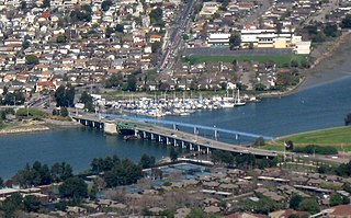
The Park Street Bridge is a double-leaf bascule drawbridge spanning 372 feet of the Oakland Estuary in the San Francisco Bay Area. It links the cities of Oakland and Alameda. In a year, the bridge is opened approximately 1700 times and carries approximately 40,000 vehicles per work day. It was built when the Oakland Estuary was trenched, converting Alameda from a peninsula to an island.
The Fruitvale Bridge and the Fruitvale Avenue Bridge are parallel bridges that cross the Oakland Estuary, linking the cities of Oakland and Alameda in California. The Fruitvale Bridge is a vertical-lift Warren through truss railroad moveable bridge, while the Fruitvale Avenue Bridge is a steel stringer road bascule bridge that connects Fruitvale Avenue in Oakland with Tilden Way in Alameda.
The Yerba Buena Tunnel, also known as the Yerba Buena Island Tunnel, is a highway tunnel in San Francisco, California. It is the part of San Francisco–Oakland Bay Bridge complex that crosses Yerba Buena Island. The Yerba Buena Tunnel carries ten lanes of Interstate 80 (I-80) on two decks, connecting the two component spans of the Bay Bridge, the western suspension span and the eastern self-anchored suspension span. At the opening of the Bay Bridge in 1936, it was the world's largest-bore tunnel.
The Southern Crossing is a proposed highway structure that would span San Francisco Bay in California, somewhere south of the San Francisco–Oakland Bay Bridge and north of the San Mateo–Hayward Bridge. Several proposals have been made since 1947, varying in design and specific location, but none of them have ever been implemented because of cost, environmental and other concerns.
The High Street Bridge is a double-leaf bascule drawbridge spanning 296 feet of the Oakland Estuary in the San Francisco Bay Area, California, United States. It links the cities of Oakland and Alameda. The bridge is opened approximately 1,400 times a year. The bridge carries an average of 26,000 vehicles per year. The bridge was built when the Oakland Estuary was trenched, converting Alameda from a peninsula to an island.
Alameda Island is an island located in the San Francisco Bay in California. It is south and west of, and adjacent to, Oakland, and across the bay eastward from San Francisco. Located on the island is most of the city of Alameda, a city in Alameda County. A very small western tip of the island's territory is technically part of San Francisco, however, this is uninhabited and is not separately managed.
The San Leandro Bay Bridge, better known as the Bay Farm Island Bridge, is a single-leaf bascule drawbridge spanning the San Leandro Channel, the inlet of San Leandro Bay within the San Francisco Bay Area, California, United States. It carries California State Route 61 and links the main island of Alameda with Bay Farm Island within the city of Alameda. The present bridge was completed in 1953; it is paralleled by a second bridge devoted to pedestrian and bicycle traffic, the Bay Farm Island Bicycle Bridge.
References
↑ Baughn, James. "Posey Tube". Bridgehunter. Retrieved 19 March 2019.
↑ "Bay Crossings Report". California Highways and Public Works. Vol.27, no.11–12. Division of Highways, Department of Public Works, State of California. November–December 1948. p.5. Alternate URL
1 2 3 4 5 Parker, P.E.; Whitlock, H.J. (March–April 1960). "Webster St. Tube". California Highways and Public Works. Vol.39, no.3–4. Division of Highways, Department of Public Works, State of California. pp.11–12, 67. Alternate URL
↑ "Record Move". California Highways and Public Works. Vol.38, no.11–12. Division of Highways, Department of Public Works, State of California. November–December 1959. pp.42–43.
↑ Names, W.C.; Wolfson, William F. (March–April 1963). "Webster St. Tube". California Highways and Public Works. Vol.42, no.3–4. Division of Highways, Department of Public Works, State of California. pp.10–14. Alternate URL
1 2 Sinclair, J.P. (May–June 1963). "Bay Area Report—1963". California Highways and Public Works. Vol.42, no.5–7. Division of Highways, Department of Public Works, State of California. p.28;32–33. Alternate URL
↑ Greene, George A.; Pomeroy, E.G. (January–February 1961). "Tube Report". California Highways and Public Works. Vol.40, no.1–2. Division of Highways, Department of Public Works, State of California. pp.25–31. Alternate URL
1 2 3 Sinclair, J.P. (May–June 1962). "Bay Area Report". California Highways and Public Works. Vol.41, no.5–7. Division of Highways, Department of Public Works, State of California. p.14. Alternate URL
↑ Skootsky, Harold; Brass, John R. (September–October 1959). "Tunnel Lighting". California Highways and Public Works. Vol.38, no.9–10. Division of Highways, Department of Public Works, State of California. pp.43–46, 53.
↑ Sundahl, Carl (August 14, 1961). "Tile Layers 19 Notes". Organized Labor. Retrieved 11 September 2020.
↑ "Bridges". California Highways and Public Works. Vol.40, no.11–12. Division of Highways, Department of Public Works, State of California. November–December 1961. p.56. Alternate URL
↑ "THX 1138". Berkeley Art Museum and Pacific Film Archive. Retrieved 10 September 2020.
Methods Used in the Construction of Twelve Pre-cast Concrete Segments for the Alameda County, California, Estuary Subway, in American Society of Civil Engineers, Proceedings, 53 (2): 2675–2692 (December, 1927)
S. W. Gibbs,Construction Methods on Oakland Estuary Tube, in Engineering News Record, 100:100–105 (January 19, 1928)
Lortie, Frank (1995). "A Monument to Progress: The Posey Tube and the East Bay's Transition to the Age of the Automobile". California History. 74 (4): 422–433. doi:10.2307/25177536. JSTOR25177536.
Building Big David Macauley ISBN0-395-96331-1 A companion to PBS television series Building Big series PAGES 76–77 explain ventilation system for Holland Tunnel
This page is based on this Wikipedia article Text is available under the CC BY-SA 4.0 license; additional terms may apply. Images, videos and audio are available under their respective licenses.