Weston-super-Mare, also known simply as Weston, is a seaside town in the North Somerset unitary area in the county of Somerset, England. It lies by the Bristol Channel 20 miles (32 km) south-west of Bristol between Worlebury Hill and Bleadon Hill. Its population at the 2021 census was 82,418.

Magatama are curved, comma-shaped beads that appeared in prehistoric Japan from the Final Jōmon period through the Kofun period, approximately 1000 BCE to the 6th century CE. The beads, also described as "jewels", were made of primitive stone and earthen materials in the early period, but by the end of the Kofun period were made almost exclusively of jade. Magatama originally served as decorative jewelry, but by the end of the Kofun period functioned as ceremonial and religious objects. Archaeological evidence suggests that magatama were produced in specific areas of Japan and were widely dispersed throughout the Japanese archipelago to the Southern Koreanic kingdoms via trade routes.
The word pā can refer to any Māori village or defensive settlement, but often refers to hillforts – fortified settlements with palisades and defensive terraces – and also to fortified villages. Pā sites occur mainly in the North Island of New Zealand, north of Lake Taupō. Over 5,000 sites have been located, photographed and examined, although few have been subject to detailed analysis. No pā have been yet located from the early colonization period when early Polynesian-Māori colonizers lived in the lower South Island. Variations similar to pā occur throughout central Polynesia, in the islands of Fiji, Tonga and the Marquesas Islands.
The year 1994 in archaeology involved some significant events.

Worlebury Hill is the name given to an upland area lying between the flatlands of Weston-super-Mare and the Kewstoke area of North Somerset, England. Worlebury Hill's rises from sea level to its highest point of 109 metres (358 ft), and the western end of the hill forms a peninsula, jutting out into the Bristol Channel, between Weston Bay and Sand Bay. A toll road follows the coast around the hill from Sand Bay in the north to the now derelict Birnbeck Pier in the west, although tolls are not currently collected on the road. Worlebury Golf Club is situated on the Hill and the area is known for being one of the wealthiest areas in the county of Somerset.

Yoshinogari is the name of a large and complex Yayoi archaeological site in Yoshinogari and Kanzaki in Saga Prefecture, Kyūshū, Japan. According to the Yayoi chronology established by pottery seriations in the 20th century, Yoshinogari dates to between the 3rd century BC and the 3rd century AD. However, recent attempts to use absolute dating methods such as AMS radiocarbon dating have shown that the earliest Yayoi component of Yoshinogari dates to before 400 BC.

Birnbeck Pier, also known as the 'Old Pier', is a pier situated on the Bristol Channel in Weston-super-Mare, North Somerset, England, approximately 18 miles (29 km) south-west of Bristol. It is the only pier in the country which links the mainland to an island, linking to Birnbeck Island, a 1.2-hectare (3-acre) rocky island just to the west of Worlebury Hill. The grade II* listed pier was designed by Eugenius Birch and opened in 1867. Birnbeck Pier is one of only six Grade II* piers surviving in the country. The refreshment and waiting rooms of 1898 were designed by local architect Hans Price and the clocktower and the piermaster's house have been attributed to him. The pier has been closed to the public since 1994 and is now on the Buildings at Risk Register.

Hans Price (1835–1912) was the architect responsible for much of the development of Weston-super-Mare, in North Somerset, England, during the Victorian era.

Banwell is a village and civil parish on the River Banwell in the North Somerset district of Somerset, England. Its population was 3,251 according to the 2021 census.

Weston Museum is a museum in Weston-super-Mare, North Somerset, England. It was established in 1861. and is home to North Somerset Council museum collection with exhibits relating to Weston-super-Mare and the surrounding area from 400 million years ago to the present day.

The Sannai-Maruyama Site is an archaeological site and museum located in the Maruyama and Yasuta neighborhoods to the southwest of central Aomori in Aomori Prefecture in northern Japan, containing the ruins of a very large Jōmon period settlement. The ruins of a 40-hectare settlement were discovered in 1992, when Aomori Prefecture started surveying the area for a planned baseball stadium. Archaeologists have used this site to further their understanding of the transition to sedentism and the life of the Jōmon people. Excavation has led to the discovery of storage pits, above ground storage and long houses. These findings demonstrate a change in the structure of the community, architecture, and organizational behaviors of these people. Because of the extensive information and importance, this site was designated as a Special National Historical Site of Japan in 2000., and a UNESCO World Heritage Site as part of the Jōmon Prehistoric Sites in Northern Japan collection in 2021. Today the public can visit the site, its various reconstructions of Jōmon structures, and a museum that displays and houses artifacts collected on the site, which have collectively been designated an Important Cultural Property
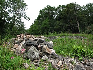
Worlebury Camp is the site of an Iron Age hillfort on Worlebury Hill, north of Weston-super-Mare in Somerset, England. The fort was well defended with numerous walls, embankments and ditches around the site. Several large triangular platforms have been uncovered around the sides of the fort, lower down on the hillside. Nearly one hundred storage pits of various sizes were cut into the bedrock, and many of these contained human remains, coins, and other artefacts. During the 19th and 20th centuries the fort suffered damage and was threatened with complete destruction on multiple occasions. Now, the site is a designated Scheduled monument. It falls within the Weston Woods Local Nature Reserve which was declared to Natural England by the North Somerset Council in 2005.

Jōmon Prehistoric Sites in Northern Japan (北海道・北東北の縄文遺跡群) is a serial UNESCO World Heritage Site consisting of 17 Jōmon-period archaeological sites in Hokkaidō and northern Tōhoku, Japan. The Jōmon period lasted more than 10,000 years, representing "sedentary pre-agricultural lifeways and a complex spiritual culture of prehistoric people".
The Komakino Site is an archaeological site located in the city of Aomori, Aomori Prefecture, in the Tōhoku region of northern Japan containing the ruins of a late Jōmon period settlement. The remains were designated a National Historic Site in 1995 by the Japanese government. The site is located a short distance to the south of the famous Sannai-Maruyama Site.

The Ōmori Katsuyama Site is an archaeological site in the city of Hirosaki, Aomori Prefecture, in the Tōhoku region of northern Japan that contains the ruins of a late Jōmon period settlement dating to approximately 2,000–1,500 BC. The remains were designated a National Historic Site in 2012 by the Japanese government.

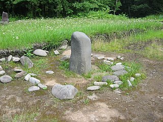
The Akyū ruins is an archaeological site containing the ruins of a large-scale Jōmon period settlement located in the Kawagishi neighborhood of the village of Hara, Suwa District, Nagano in the Chūbu region of Japan. It contains the largest stone circle yet found in Japan. The site was designated a National Historic Site of Japan in 1979.
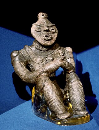
The so-called "dogū with palms pressed together" is a Japanese dogū or clay figurine of the late Jōmon period. Excavated from the Kazahari I Site in Hachinohe, Aomori Prefecture, it is exhibited at the nearby Korekawa Jōmon Kan. Alongside "Hollow Dogū" from Hokkaidō, "Jōmon Goddess" from Yamagata Prefecture, and "Jōmon Venus" and "Masked Goddess" from Nagano Prefecture, it is one of five dogū that have been designated National Treasures.
The Ichinosaka ruins is an archaeological site containing the ruins of an early Jōmon period settlement located in what is now part of the city of Yonezawa, Yamagata in the Tōhoku region of Japan. The site was designated a National Historic Site of Japan in 1997.
The Soya Shell Midden is an archaeological site in the Soya neighborhood of the city of Ichikawa, Chiba Prefecture, in the Kantō region of Japan containing a Jōmon period shell midden and settlement ruin. It was designated a National Historic Site of Japan in 1979. The shell mound was formed in the latter half of the Jōmon period, about 4000 to 3000 years ago.
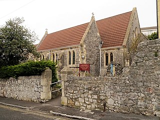
St Joseph's Church is a Roman Catholic parish church in Weston-super-Mare, Somerset, England. It was built in 1858, and was designed by Charles Francis Hansom and extended by Alexander Scoles in 1893. It is located on Camp Road to the north of the town centre. It was first Catholic church to be built in Weston-super-Mare since the Reformation and it is in the Gothic Revival style.

