Pueblo Bonito

Last updated

Pueblo Bonito
Pueblo Bonito Aerial.JPG
Aerial view, from the south
Pueblo Bonito SM.png
Site map
Location San Juan County, New Mexico, Flag of the United States.svg  USA
Coordinates 36°03′39″N107°57′42″W / 36.0607°N 107.9617°W / 36.0607; -107.9617
First occupied828
Built by Chacoan civilization
Abandoned1126
Governing bodyPrivate
USA New Mexico location map.svg
Red pog.svg
Located in present-day New Mexico
Pueblo Bonito

Pueblo Bonito (Spanish for beautiful town) is the largest and best-known great house in Chaco Culture National Historical Park, northern New Mexico. It was built by the Ancestral Puebloans who occupied the structure between AD 828 and 1126.

Contents

According to the National Park Service, "Pueblo Bonito is the most thoroughly investigated and celebrated cultural site in Chaco Canyon. Planned and constructed in stages between AD 850 to AD 1150 by ancestral Puebloan peoples, this was the center of the Chacoan world." [1] Anthropologist Brian Fagan has said that "Pueblo Bonito is an archeological icon, as famous as England's Stonehenge, Mexico's Teotihuacan, or Peru's Machu Picchu." [2]

In January 1941, a section of the canyon wall known as Threatening Rock, or tse biyaa anii'ahi (leaning rock gap) in Navajo, collapsed as a result of a rock fall, destroying some of the structure's rear wall and a number of rooms. The builders of Pueblo Bonito appear to have been well aware of this threat, but chose to build beneath the fractured stone anyway. The wall stood 97 feet (30 m) high and weighed approximately 30,000 tons; the Puebloans compensated by building structural reinforcements for the slab.

In 2009, traces of Mexican cacao from at least 1,200 miles (1,900 km) away were detected in pottery sherds at Pueblo Bonito. This was the first demonstration that the substance, important in rituals, had been brought into the area that became the United States at any time before the Spanish arrived around 1500. Cylindrical pottery jars, common in Central America, had previously been found there, but are rare. 111 jars have been found in Pueblo Bonito's 800 or so rooms. [3]

Discovery

Pueblo Bonito from the south Pueblo Bonito, Chaco Canyon New Mexico.JPG
Pueblo Bonito from the south

United States army Lt. James H. Simpson and his guide, Carravahal, from San Ysidro, New Mexico, discovered Chaco Canyon during an 1849 military expedition. [4] They briefly examined eight large ruins in Chaco Canyon, and Carravahal gave them their Spanish names, including Pueblo Bonito, meaning beautiful village. [5] Simpson later published the first description of Chaco Canyon in his military report, with drawings by expedition artist R. H. Kern. [6]

Rancher Richard Wetherill and natural history student George H. Pepper from the American Museum of Natural History, began excavations at Pueblo Bonito in 1896 and ended in 1900. These excavations were financed by B. Talbot Hyde and Frederick E. Hyde, Jr. of New York City, who were philanthropists and collectors. During this time, the two men uncovered 190 rooms and photographed and mapped all major structures in the canyon.

Pueblo Bonito from the east, 2006 PuebloBonito2006.JPG
Pueblo Bonito from the east, 2006

Among the artifacts recovered by Pepper, eight wood flutes were found in a room in the northwestern part of Pueblo Bonito that Pepper designated as "Room 33". These flutes are in the style of the Anasazi flutes that are considered a predecessor to the Native American flute. [7] [8] The rituals at Pueblo Bonito were performed with cylindrical vessels, human effigy vessels, and ceramic incense burners. [9] The Hydes donated the resulting large collection of artifacts to the American Museum of Natural History. After the excavation, Wetherill sought to gain personal control of parts of Chaco Canyon, including Pueblo Bonito, Chetro Ketl, and Pueblo Del Arroyo. He filed a homestead entry on these ruins, which was invalidated by the General Land Office in 1904 when the federal government took formal possession of these lands. Wetherill was required to stop his ongoing excavations on federal property, but continued to run a trading post at Chaco Canyon until his death in 1910.

Description

Kivas and square rooms in the southeast section of Pueblo Bonito, from cliff, 1929. Photo by George A. Grant PB kivas.jpg
Kivas and square rooms in the southeast section of Pueblo Bonito, from cliff, 1929. Photo by George A. Grant

Pueblo Bonito is divided into two sections by a precisely aligned wall which runs north to south through the central plaza. A Great Kiva is situated on either side of the wall, creating a symmetrical pattern common to many of the Great Houses. In addition to the Great Kivas, over thirty other kivas or ceremonial structures have been found, many also associated with the large central courtyard. Interior living spaces were quite large by the standards of the Ancient Pueblo.

The site covers 3 acres (1.2 ha) and incorporates approximately 800 rooms. [10] In parts of the village, the tiered structure was four and five stories high. During later construction, some lower level rooms were filled with debris to better support the weight of the upper levels. The builder's use of core-and-veneer architecture and multi-story construction produced massive masonry walls as much as 3 feet (0.91 m) thick.

Population estimates for the village vary. During the early 20th century, the structures were viewed as small cities, with people residing in every room. From this perspective, Pueblo Bonito could have accommodated several thousand inhabitants at its peak. Recent analysis has lowered the estimated population to less than 800, primarily due to the small number of usable hearths in the ruins. An analysis based on architecture estimated the resident population at 12 households, or about 70 people at its peak. [11] These tend to be located on the ground floor, near the central plaza, and are associated with entrances to a series of rooms going deeper into the structure. Rooms were connected by a series of interior doorways, some of them in a T-shape. A family may have inhabited 3 to 4 rooms, with many small interior spaces being used for storage. There was generally no outside access to the room blocks other than from the central courtyard.

Interior wall with exposed timber beams and aligned doorways A330, Chaco Culture National Historical Park, New Mexico, USA, 2011.JPG
Interior wall with exposed timber beams and aligned doorways

It is possible that Pueblo Bonito is actually neither a village nor city. While its size has the capacity for a significant population, the environment may not have been ideal for sustaining a large population. Excavations at the site have not revealed significant trash middens indicating residential areas. A common suggestion is that Pueblo Bonito was a ritual center. This is evident in not only the existence of the kivas (which are more often than not attributed to ritual function) but also the construction of the site and its relation to other Chaco Canyon sites. Although there were many occupants, only 50-60 burials were found here. [9]

The site indicates the Puebloans' comprehension of solar and lunar cycles; both of which are marked in the petroglyphs of the surrounding cliff area as well as in the architecture of Pueblo Bonito itself.

Pueblo Bonito is the largest great house in Chaco Canyon, New Mexico. Pueblo Bonito Cliff View.jpg
Pueblo Bonito is the largest great house in Chaco Canyon, New Mexico.

Examination of pack rat middens revealed that at the time that Pueblo Bonito was built, Chaco Canyon and the surrounding areas were wooded by trees such as ponderosa pines. Evidence of such trees can be seen within the structure of Pueblo Bonito, such as the first-floor support beams. Scientists hypothesized that during the time when the pueblo was inhabited, the valley was cleared of almost all of the trees, to provide timber for construction and fuel. This tree removal, combined with a period of drought, led the water table in the valley to drop severely, making the land infertile. This explains why Pueblo Bonito was inhabited for only about 300 years and is a good example of the effect that deforestation can have on the local environment. The Ancestral Puebloans, no longer able to grow crops to sustain their population, had to move on.

Matriliny

Room 33 is one of the most well-excavated areas of Pueblo Bonito and belongs to the earliest construction phase of the site in the 9th century. A concentration of elite burials occurred in room 33, which are differentiated from other burials in Chaco Canyon since most people were buried outside the great houses. [12] The oldest burial was of a man who died violently, and archaeologists believe that room 33 was built as a crypt for him and his descendants. [13] He was buried with thousands of turquoise and shell beads and pendants, which originally formed necklaces, anklets and bracelets, making his the richest burial ever excavated in the Southwest. [14] [15] [13] Over the next 330 years, thirteen other individuals (both men and women) were buried in the same crypt with many elite grave goods suggesting important ritual functions in the community. Archaeogenomic analysis found that nine of these individuals shared mitochondrial DNA, meaning they were all related through the female line. Archaeologists have concluded that Pueblo Bonito was associated with an elite matriline, a powerful family who inherited their status from their mothers, for approximately 330 years. The room 33 excavations are the first archaeological evidence of matrilineal descent among the Ancestral Puebloans, which is a further link to their modern Pueblo descendants, many of whom practice matrilineal succession. [13]

Construction

The archeologist Mary Metcalf estimates that 805,000 man-hours were required to build Pueblo Bonito's main structure. [16]

Rock art

On the rock wall directly behind Pueblo Bonito is a series of petroglyphs depicting six-toed feet, a stylistic element also found in other Ancient Pueblo rock art. These images date to the late 10th or early 11th centuries. [17]

Related Research Articles

<span class="mw-page-title-main">Mesa Verde National Park</span> U.S. national park in Colorado

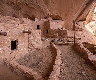
Mesa Verde National Park is an American national park and UNESCO World Heritage Site located in Montezuma County, Colorado. The park protects some of the best-preserved Ancestral Puebloan archaeological sites in the United States.

The Pecos Classification is a chronological division of all known Ancestral Puebloans into periods based on changes in architecture, art, pottery, and cultural remains. The original classification dates back to consensus reached at a 1927 archæological conference held in Pecos, New Mexico, which was organized by the United States archaeologist Alfred V. Kidder.

<span class="mw-page-title-main">Kiva</span> Room used by Puebloans for religious rituals and political meetings

A kiva is a space used by Puebloans for rites and political meetings, many of them associated with the kachina belief system. Among the modern Hopi and most other Pueblo peoples, "kiva" means a large room that is circular and underground, and used for spiritual ceremonies.

<span class="mw-page-title-main">Chaco Culture National Historical Park</span> U.S. national park in New Mexico

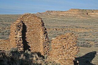
Chaco Culture National Historical Park is a United States National Historical Park in the American Southwest hosting a concentration of pueblos. The park is located in northwestern New Mexico, between Albuquerque and Farmington, in a remote canyon cut by the Chaco Wash. Containing the most sweeping collection of ancient ruins north of Mexico, the park preserves one of the most important pre-Columbian cultural and historical areas in the United States.

<span class="mw-page-title-main">Navajo National Monument</span> National monument in Arizona, United States

Navajo National Monument is a National Monument located within the northwest portion of the Navajo Nation territory in northern Arizona, which was established to preserve three well-preserved cliff dwellings of the Ancestral Puebloan people: Keet Seel, Betatakin, and Inscription House. The monument is high on the Shonto plateau, overlooking the Tsegi Canyon system, west of Kayenta, Arizona. It features a visitor center with a museum, three short self-guided trails, two small campgrounds, and a picnic area.

<span class="mw-page-title-main">Richard Wetherill</span> American archaeologist

Richard Wetherill (1858–1910), a member of a Colorado ranching family, was an amateur archaeologist who discovered, researched and excavated sites associated with the Ancient Pueblo People. He is credited with the rediscovery of Cliff Palace in Mesa Verde in Colorado and was responsible for initially selecting the term Anasazi, Navajo for ancient enemies, as the name for these ancient people. He also excavated Kiet Seel ruin, now in Navajo National Monument in northeastern Arizona, and Pueblo Bonito in Chaco Canyon, New Mexico.

<span class="mw-page-title-main">Salmon Ruins</span> United States historic place

Salmon Ruins is an ancient Chacoan and Pueblo site located in the northwest corner of New Mexico, USA. Salmon was constructed by migrants from Chaco Canyon around 1090 CE, with 275 to 300 original rooms spread across three stories, an elevated tower kiva in its central portion, and a great kiva in its plaza. Subsequent use by local Middle San Juan people resulted in extensive modifications to the original building, with the reuse of hundreds of rooms, division of many of the original large, Chacoan rooms into smaller rooms, and emplacement of more than 20 small kivas into pueblo rooms and plaza areas. The site was occupied by ancient Ancestral Puebloans until the 1280s, when much of the site was destroyed by fire and abandoned. The pueblo is situated on the north bank of the San Juan River, just to the west of the modern town of Bloomfield, New Mexico, and about 45 miles (72 km) north of Pueblo Bonito in Chaco Canyon. The site was built on the first alluvial terrace above the San Juan River floodplain.

A timeline of Chacoan history includes Chaco Culture National Historical Park, Aztec Ruins National Monument, Twin Angels Pueblo, Casamero Pueblo, Kin Nizhoni, Pierre's Site, and Halfway House.

<span class="mw-page-title-main">Una Vida</span>

Una Vida is an archaeological site located in Chaco Canyon, San Juan County, New Mexico, United States. According to tree rings surrounding the site, its construction began around 800 AD, at the same time as Pueblo Bonito, and it is one of the three earliest Chacoan Ancestral Puebloan great houses. Comprising at least two stories and 160 rooms, it shares an arc or D-shaped design with its contemporaries, Peñasco Blanco and Pueblo Bonito, but has a unique "dog leg" addition made necessary by topography. It is located in one of the canyon's major side drainages, near Gallo Wash, and was massively expanded after 930 AD.

<span class="mw-page-title-main">Chetro Ketl</span> Ancestral Puebloan archeological site in New Mexico, US

Chetro Ketl is an Ancestral Puebloan great house and archeological site located in Chaco Culture National Historical Park, New Mexico, United States. Construction on Chetro Ketl began c. 990 and was largely complete by 1075, with significant remodeling occurring in the early and mid-1110s. Following the onset of a severe drought, most Chacoans emigrated from the canyon by 1140; by 1250 Chetro Ketl's last inhabitants had vacated the structure.

<span class="mw-page-title-main">Pueblo del Arroyo</span>

Pueblo del Arroyo is an Ancestral Puebloan great house and archaeological site located in Chaco Culture National Historical Park, in New Mexico, United States.

<span class="mw-page-title-main">Ancestral Puebloan dwellings</span> Ancestral Puebloan homes

Hundreds of Ancestral Puebloan dwellings are found across the American Southwest. With almost all constructed well before 1492 CE, these Puebloan towns and villages are located throughout the geography of the Southwest.

<span class="mw-page-title-main">Ansel Hall Ruin</span> Archaeological site in Colorado, United States

The Ansel Hall Ruin, also known as Cahone Ruin, is located in Cahone, Dolores County, Colorado. A pre-historic ruins from the Pueblo II period, the Northern San Juan pueblo was added to the National Register of Historic Places in 1997.

<span class="mw-page-title-main">Pueblo I Period</span> Era in the history of the Pueblo peoples

The Pueblo I Period was the first period in which Ancestral Puebloans began living in pueblo structures and realized an evolution in architecture, artistic expression, and water conservation.

<span class="mw-page-title-main">Pueblo II Period</span> Era in the history of the Pueblo peoples

The Pueblo II Period was the second pueblo period of the Ancestral Puebloans of the Four Corners region of the American southwest. During this period people lived in dwellings made of stone and mortar, enjoyed communal activities in kivas, built towers and dams for water conservation, and implemented milling bins for processing maize. Communities with low-yield farms traded pottery with other settlements for maize.

<span class="mw-page-title-main">Pueblo III Period</span> Era in the history of the Pueblo peoples

The Pueblo III Period was the third period, also called the "Great Pueblo period" when Ancestral Puebloans lived in large cliff-dwelling, multi-storied pueblo, or cliff-side talus house communities. By the end of the period, the ancient people of the Four Corners region migrated south into larger, centralized pueblos in central and southern Arizona and New Mexico.

<span class="mw-page-title-main">Ancestral Puebloans</span> Ancient Native American culture in Four Corners region of the US

The Ancestral Puebloans, also known as the Anasazi, were an ancient Native American culture that spanned the present-day Four Corners region of the United States, comprising southeastern Utah, northeastern Arizona, northwestern New Mexico, and southwestern Colorado. They are believed to have developed, at least in part, from the Oshara tradition, which developed from the Picosa culture. The people and their archaeological culture are often referred to as Anasazi, meaning "ancient enemies", as they were called by Navajo. Contemporary Puebloans object to the use of this term, with some viewing it as derogatory.

Leyit Kin is an Ancestral Puebloan small house archeological site located 1 mile (1.6 km) southeast of Pueblo Bonito near the south end of Chaco Canyon in New Mexico, United States. Leyit Kin contains three kivas and twenty-seven rooms. It was occupied during three distinct periods ending in the late 12th century. The site was partially excavated in 1934 and 1936, but backfilling has made the structures nearly indistinguishable from the surrounding landscape.

East Community is an Ancestral Puebloan great house community and archeological site located 12 miles (19 km) east of Pueblo Bonito, at the eastern end of Chaco Culture National Historical Park, New Mexico, United States. Archeological evidence uncovered during the 1980s suggests the site was occupied by both Chacoans and Mesa Verdeans. Eighty-two structures have been identified in the area, including a great house that contains twenty-five rooms and several small house sites. At least one kiva has been uncovered there, but no great kivas. A partial road segment is visible there, but archeologists are unsure if it connects with a longer segment thought to originate near Pueblo Pintado. The great house at East Community was constructed in the 10th century, with significant additions completed during the 11th century. The associated small house sites were occupied by Chacoans from 875 to 1300, and thirty-nine of them by Mesa Verdeans, from 1175 to 1300. Archeologist Thomas Windes believes the site was linked to Chaco Canyon through a system of signaling stations atop the area's mesas.

References

  1. National Park Service.
  2. Fagan 2005, p. 117.
  3. Thomas H. Maugh II (February 3, 2009). "Earlier traces of cacao use found in Southwest". Los Angeles Times.
  4. Reed 2004, pp. 16, 106.
  5. Reed 2004, pp. 16–7.
  6. Reed 2004, pp. 116–7.
  7. Clint Goss (2012). "The Development of Flutes in North American: The Pueblo Bonito and other Mojave Flutes". Flutopedia. Retrieved February 13, 2012.
  8. Clint Goss (2012). "The Flutes of Pueblo Bonito". Flutopedia. Retrieved February 14, 2012.
  9. 1 2 Snow 2010, p. 131.
  10. Judd 1957, p. 561.
  11. Bernardini, Wesley (1999). "Reassessing the scale of social action at Pueblo Bonito, Chaco Canyon, New Mexico". Kiva, the Journal of Southwest Anthropology and History. 64 (4): 447–470.
  12. Plog, S.; Heitman, C. (November 8, 2010). "Hierarchy and social inequality in the American Southwest, A.D. 800-1200". Proceedings of the National Academy of Sciences. 107 (46): 19619–19626. doi: 10.1073/pnas.1014985107 . ISSN   0027-8424. PMC   2993351 . PMID   21059921.
  13. 1 2 3 Perry, George H.; Reich, David; Whiteley, Peter M.; LeBlanc, Steven A.; Kistler, Logan; Stewardson, Kristin; Swapan Mallick; Rohland, Nadin; Skoglund, Pontus (February 21, 2017). "Archaeogenomic evidence reveals prehistoric matrilineal dynasty". Nature Communications. 8: 14115. Bibcode:2017NatCo...814115K. doi:10.1038/ncomms14115. ISSN   2041-1723. PMC   5321759 . PMID   28221340.
  14. Hodge, Frederick Webb; Leary, Ella (1916). Holmes anniversary volume; anthropological essays presented to William Henry Holmes in honor of his seventieth birthday, December 1, 1916. Washington: [Printed at the J.W. Bryan press]. doi:10.5962/bhl.title.61163. hdl:2027/umn.31951p00853855t.
  15. Pepper, G. H. Anthropological Papersof the American Museum of Natural History Vol. XXVII, (New York, (1920).
  16. Fagan 2005, p. 143.
  17. University of Colorado Boulder.

Bibliography

Further reading