
Area is the measure of a region's size on a surface. The area of a plane region or plane area refers to the area of a shape or planar lamina, while surface area refers to the area of an open surface or the boundary of a three-dimensional object. Area can be understood as the amount of material with a given thickness that would be necessary to fashion a model of the shape, or the amount of paint necessary to cover the surface with a single coat. It is the two-dimensional analogue of the length of a curve or the volume of a solid . Two different regions may have the same area ; by synecdoche, "area" sometimes is used to refer to the region, as in a "polygonal area".
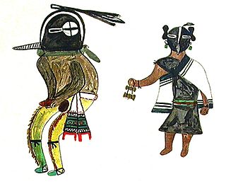
Kokopelli is a fertility deity, usually depicted as a humpbacked flute player, who is venerated by some Native American cultures in the Southwestern United States. Like most fertility deities, Kokopelli presides over both childbirth and agriculture. He is also a trickster god and represents the spirit of music.

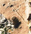
Newspaper Rock State Historic Monument is a Utah state monument featuring a rock panel carved with one of the largest known collections of petroglyphs. It is located in San Juan County, along Utah State Route 211, 28 miles (45 km) northwest of Monticello and 53 miles (85 km) south of Moab.

A petroglyph is an image created by removing part of a rock surface by incising, picking, carving, or abrading, as a form of rock art. Outside North America, scholars often use terms such as "carving", "engraving", or other descriptions of the technique to refer to such images. Petroglyphs, estimated to be 20,000 years old are classified as protected monuments and have been added to the tentative list of UNESCO's World Heritage Sites. Petroglyphs are found worldwide, and are often associated with prehistoric peoples. The word comes from the Greek prefix petro-, from πέτρα petra meaning "stone", and γλύφω glýphō meaning "carve", and was originally coined in French as pétroglyphe.
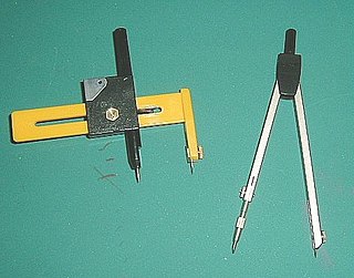
A compass, more accurately known as a pair of compasses, is a technical drawing instrument that can be used for inscribing circles or arcs. As dividers, it can also be used as a tool to mark out distances, in particular, on maps. Compasses can be used for mathematics, drafting, navigation and other purposes.

The Paria River is a tributary of the Colorado River, approximately 95 miles (153 km) long, in southern Utah and northern Arizona in the United States. It drains a rugged and arid region northwest of the Colorado, flowing through roadless slot canyons along part of its course.
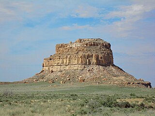
Fajada Butte is a butte in Chaco Culture National Historical Park, in northwest New Mexico.
The Virgin Anasazi were the westernmost Ancestral Puebloan group in the American Southwest. They occupied the area in and around the Virgin River and Muddy Rivers, the western Colorado Plateau, the Moapa Valley and were bordered to the south by the Colorado River. They occupied areas in present-day Nevada, Arizona, and Utah. Their occupation of the area lasted from about 1 CE to around 1200 CE, which according to the Pecos Classification places the occupation from Early Basketmaker II Era to Early Pueblo III periods. Their neighbors were the Fremont culture to the north and the Kayenta Anasazi to the east.

Chumash rock art is a genre of paintings on caves, mountains, cliffs, or other living rock surfaces, created by the Chumash people of Southern California. Pictographs and petroglyphs are common through interior California, the rock painting tradition thrived until the 19th century. Chumash rock art is considered to be some of the most elaborate and plentiful rock art tradition in the region.

In geometry, a line segment is a part of a straight line that is bounded by two distinct end points, and contains every point on the line that is between its endpoints. It is a special case of an arc, with zero curvature. The length of a line segment is given by the Euclidean distance between its endpoints. A closed line segment includes both endpoints, while an open line segment excludes both endpoints; a half-open line segment includes exactly one of the endpoints. In geometry, a line segment is often denoted using an overline (vinculum) above the symbols for the two endpoints, such as in AB.

The Painted Rock Petroglyph Site is a collection of hundreds of ancient petroglyphs near the town of Theba, Arizona, United States, listed on the National Register of Historic Places in 1977. The site is operated and maintained by the Bureau of Land Management (BLM), and includes an improved campground as well as an informative walking trail showcasing the petroglyphs.

Drafting tools may be used for measurement and layout of drawings, or to improve the consistency and speed of creation of standard drawing elements. Tools such as pens and pencils mark the drawing medium. Other tools such as straight edges, assist the operator in drawing straight lines, or assist the operator in drawing complicated shapes repeatedly. Various scales and the protractor are used to measure the lengths of lines and angles, allowing accurate scale drawing to be carried out. The compass is used to draw arcs and circles. A drawing board was used to hold the drawing media in place; later boards included drafting machines that sped the layout of straight lines and angles. Tools such as templates and lettering guides assisted in the drawing of repetitive elements such as circles, ellipses, schematic symbols and text. Other auxiliary tools were used for special drawing purposes or for functions related to the preparation and revision of drawings. The tools used for manual technical drawing have been displaced by the advent of computer-aided drawing, drafting and design (CADD).

Huápoca is an archaeological site located 36 kilometers west of Ciudad Madera, in the Huápoca Canyon region, northwest of the Mexican state of Chihuahua.

The Pueblo III Period was the third period, also called the "Great Pueblo period" when Ancestral Puebloans lived in large cliff-dwelling, multi-storied pueblo, or cliff-side talus house communities. By the end of the period, the ancient people of the Four Corners region migrated south into larger, centralized pueblos in central and southern Arizona and New Mexico.
The Pueblo IV Period was the fourth period of ancient pueblo life in the American Southwest. At the end of prior Pueblo III Period, Ancestral Puebloans living in the Colorado and Utah regions abandoned their settlements and migrated south to the Pecos River and Rio Grande valleys. As a result, pueblos in those areas saw a significant increase in total population.
The Basketmaker III Era also called the "Modified Basketmaker" period, was the third period in which Ancient Pueblo People were cultivating food, began making pottery and living in more sophisticated clusters of pit-house dwellings. Hunting was easier with the adoption of the bow and arrow.

The Early Basketmaker II Era was the first Post-Archaic cultural period of Ancient Pueblo People. The era began with the cultivation of maize in the northern American southwest, although there was not a dependence upon agriculture until about 500 BCE. It is preceded by the Archaic-Early Basketmaker Era, and is followed by the Late Basketmaker II Era.
A typographic approximation is a replacement of an element of the writing system with another glyph or glyphs. The replacement may be a nearly homographic character, a digraph, or a character string. An approximation is different from a typographical error in that an approximation is intentional and aims to preserve the visual appearance of the original. The concept of approximation also applies to the World Wide Web and other forms of textual information available via digital media, though usually at the level of characters, not glyphs.

The Ancestral Puebloans, also known as the Anasazi, were an ancient Native American culture that spanned the present-day Four Corners region of the United States, comprising southeastern Utah, northeastern Arizona, northwestern New Mexico, and southwestern Colorado. They are believed to have developed, at least in part, from the Oshara tradition, which developed from the Picosa culture. The people and their archaeological culture are often referred to as Anasazi, meaning "ancient enemies", as they were called by Navajo. Contemporary Puebloans object to the use of this term, with some viewing it as derogatory.
Painted Bluff is a cliff overlooking the Tennessee river in Marshall County, Alabama that features over 130 individual prehistoric Native American pictographs and petroglyphs. Painted Bluff is located about 4 miles (6.4 km) downstream from the Guntersville Dam and is only accessible by boat. The bluff is divided into three levels: the low ledge along the river, a middle ledge above it, and a high ledge near the top of the cliff face. A small cave is located along the low ledge.

 Basic glyph
 Double "front" horizon and multiple "dots"
 Double horizion


