Related Research Articles

Lizard Mound County Park is a county-operated park in the Town of Farmington, Washington County, Wisconsin near the city of West Bend. Established in 1950, it was acquired by Washington County from the state of Wisconsin in 1986. It contains a significant well-preserved effigy mound group.

The Kolomoki Mounds is one of the largest and earliest Woodland period earthwork mound complexes in the Southeastern United States and is the largest in Georgia. Constructed from 350CE to 600CE, the mound complex is located in southwest Georgia, in present-day Early County near the Chattahoochee River.

Norton Mound Group,, is a prehistoric Goodall Focus mounds site near Grand Rapids, Michigan.
The Bloom Site, designated by the Smithsonian trinomial 39HS1, is an archaeological site in Hanson County, South Dakota. It was declared a National Historic Landmark in 1964.

This is a list of the National Register of Historic Places listings in Crow Wing County, Minnesota. It is intended to be a complete list of the properties and districts on the National Register of Historic Places in Crow Wing County, Minnesota, United States. The locations of National Register properties and districts for which the latitude and longitude coordinates are included below, may be seen in an online map.
This is a list of the National Register of Historic Places listings in Cass County, Minnesota. It is intended to be a complete list of the properties and districts on the National Register of Historic Places in Cass County, Minnesota, United States. The locations of National Register properties and districts for which the latitude and longitude coordinates are included below, may be seen in an online map.
This is a list of the National Register of Historic Places listings in Douglas County, Minnesota. It is intended to be a complete list of the properties and districts on the National Register of Historic Places in Douglas County, Minnesota, United States. The locations of National Register properties and districts for which the latitude and longitude coordinates are included below, may be seen in an online map.

This is a list of the National Register of Historic Places listings in Koochiching County, Minnesota. It is intended to be a complete list of the properties and districts on the National Register of Historic Places in Koochiching County, Minnesota, United States. The locations of National Register properties and districts for which the latitude and longitude coordinates are included below, may be seen in an online map.

Cranberry Creek Archeological District, also known as Cranberry Creek Mound Group, is an ancient American Indian burial mound site from circa AD 100–800 near New Miner, Wisconsin, United States. It is three miles east of Necedah National Wildlife Refuge in Juneau County. It is part of the "effigy mound culture" of native peoples in Wisconsin, who practiced the "respectful burial of their dead".

The Gee's Slough Group of Indian Mounds, located along the Lemonweir River just outside of New Lisbon, Wisconsin, is listed on the US National Register of Historic Places. The New Lisbon area was a winter gathering place for the Woodland Culture Indians who are considered the ancestors to the Ho-Chunk (Winnebago) tribe.
The Schilling Archeological District is a prehistoric Native American archaeological site on private property on Lower Grey Cloud Island in Cottage Grove, Minnesota, United States. It consists of a habitation site and mound group with artifacts that date from the Early Woodland Period to the Late Prehistoric Period. It was listed on the National Register of Historic Places in 1978 for having state-level significance in the theme of archaeology. It was nominated for its rare Early Woodland component, Middle Mississippian cultural influences, and potential to show climatic adaptations over time.
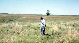
The Blueberry Lake Village Site is a prehistoric Native American archaeological site in Blueberry Township, Minnesota, United States. It consists of a habitation site, possibly seasonal, whose period and duration of occupation is uncertain. It was listed on the National Register of Historic Places in 1973 for having state-level significance in the theme of archaeology. It was nominated as one of the few surviving archaeological sites in the Shell River basin of northwestern Wadena County, the region's most conducive zone for prehistoric human habitation.
Kimball Village is an archaeological site located in the vicinity of Westfield, Iowa, United States. It is one of six known Big Sioux phase villages from the Middle Missouri Tradition that existed between 1100-1250 C.E. The site, located on a terrace overlooking the Big Sioux River, has well-preserved features, including earth lodge and storage pits, and evidence of fortifaction. The site was listed on the National Register of Historic Places in 2010, and as a National Historic Landmark in 2016.

The Upper Hay Lake Archeological District is a prehistoric Native American archaeological site in Jenkins Township, Minnesota, United States. It consists of about 75 linear mounds—including one of the state's longest at 725 feet (221 m)—plus the sites of a village and a portage. The mound grouping has also been dubbed Fort Poualak. The site was listed on the National Register of Historic Places in 1978 for having local significance in the theme of archaeology. It was nominated for indicating an area of substantial activity during the Blackduck phase of the Late Woodland period.
The Sebre Lake Site is a prehistoric Native American archaeological site in Fort Ripley Township, Minnesota, United States. It has yielded habitation and burial features accumulated over 4,000 years of intermittent use from the mid-Archaic to the early Late Woodland period. The site was listed on the National Register of Historic Places in 1984 for having local significance in the theme of archaeology. It was nominated for being one of the richest archaeological sites in the Nokasippi River Valley.
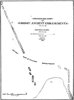
The Gordon–Schaust Site is a prehistoric Native American archaeological site in Crosslake, Minnesota, United States. It comprises two separate but nearly parallel groups of linear mounds, undated but well preserved. The site was listed on the National Register of Historic Places in 1974 for having state-level significance in the theme of archaeology.

The Fort Flatmouth Mounds form a prehistoric Native American archaeological site in Mission Township, Minnesota, United States. It consists of nine mounds grouped in a rough ellipse and a few additional mounds in close proximity. Early Euro-American settlers assumed the enclosure was built as a fort, hence the name, but it was more likely religious in nature. The site was listed on the National Register of Historic Places in 1973 for having state-level significance in the theme of archaeology. It was nominated for its information potential as a unique site in a region whose numerous mound and village sites indicate a long span of indigenous occupation.
The Four Mounds Site is a historic site located in Dubuque, Iowa, United States. It is made up of a row of four conical burial mounds on a blufftop that overlooks the Mississippi River. They are prehistoric in their origin. The site was individually listed on the National Register of Historic Places in 2000. It was included as a contributing property in the Four Mounds Estate Historic District in 2002.
Fort Juelson, designated 21OT198 in the state archaeological inventory, is a historic site located east of Underwood, Minnesota, United States. An earthen fort was built at this hilltop in July 1876 after rumors of Indian attacks in Foxhome, French, and Fergus Falls following the Battle of Little Bighorn in Montana. Many settlers left the area. Charles A. Dollner, a local merchant, suggested the rest of the people band together and build the fortification under leadership of two American Civil War veterans, Hans Juelson and Berge O. Lee. The scare proved to be a hoax, and the fort was never used for defensive purposes. Remnants of the sod barricade are still on the site.
The Orwell Site, designated 21OT7 in the state archaeological inventory, is a historic site located near Fergus Falls, Minnesota, United States. It consists of twelve Middle or Late Woodland period burial mounds, four of which are enclosed by an earthwork. They were built from about A.D. 350–600. They share similarities with the mounds found at Fort Juelson, also in Otter Tail County, with their central burial chamber. The site was listed on the National Register of Historic Places in 1974.
References
- ↑ Federal and state laws and practices restrict general public access to information regarding the specific location of this resource. In some cases, this is to protect archeological sites from vandalism, while in other cases it is restricted at the request of the owner. See: Knoerl, John; Miller, Diane; Shrimpton, Rebecca H. (1990), Guidelines for Restricting Information about Historic and Prehistoric Resources, National Register Bulletin, National Park Service, U.S. Department of the Interior, OCLC 20706997 .
- 1 2 "National Register Information System". National Register of Historic Places . National Park Service. April 15, 2008.
- ↑ Sigrid Arnott; Scott Brosowske; David Maki. "National Register of Historic Places nomination form - Fort Juelson" (PDF). Minnesota Historical Society. Archived from the original (PDF) on 2017-12-30. Retrieved 2017-12-29.
| Topics | |
|---|---|
| Lists by state |
|
| Lists by insular areas | |
| Lists by associated state | |
| Other areas | |
| Related | |

| This article about a property in Minnesota on the National Register of Historic Places is a stub. You can help Wikipedia by expanding it. |