
Thornbury is a small village and civil parish in the local government district of Torridge, Devon, England. The parish, which lies about five miles (8 km) north-east of the town of Holsworthy, comprises the five hamlets of Thornbury, Woodacott, Brendon, Lashbrook and South Wonford. These five hamlets are spread over an area of some 6 square miles (16 km2), with a distance of three miles (5 km) from Brendon to Thornbury Church. Hence, the community is quite widespread, with the only focal point being the Green at Woodacott Cross. The parish is surrounded clockwise from the north by the parishes of Milton Damerel, Bradford, Cookbury and Holsworthy Hamlets. In 2011, its population was 290, in 120 households, little changed from the 291 residents it had in 1901.

Holsworthy is a market town and civil parish in the Torridge district of Devon, England, some 36 miles (58 km) west of Exeter. The River Deer, a tributary of the River Tamar, forms the western boundary of the parish, which includes the village of Brandis Corner. According to the 2011 census the population of Holsworthy was 2,641; it was estimated at 3,287 in 2019.

Cookbury is a village and civil parish in the local government district of Torridge, Devon, England. The parish, which lies about five miles east of the town of Holsworthy, is surrounded clockwise from the north by the parishes of Thornbury, Bradford, Ashwater, Hollacombe, and Holsworthy Hamlets. In 2001 its population was 158, little changed from the 146 residents it had in 1901.

Oakford is a village and civil parish in the Mid Devon district of Devon, England. It is located three miles (5 km) south west of Bampton and eight miles (13 km) north north west of Tiverton. Oakford is near the river Exe.

High Bickington is a rural village and civil parish in the Torridge district of Devon, England. The village lies on the B3217 road, around 6 miles (10 km) east of Great Torrington, 8 miles (13 km) south-west of South Molton, and 8 miles (13 km) south of Barnstaple. At the 2011 Census, the parish had a population of 837.
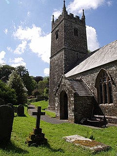
Bradford is a village and civil parish in the local government district of Torridge, Devon, England. The parish, which lies about six miles east of the town of Holsworthy has part of its eastern boundary formed by the River Torridge, and it is surrounded clockwise from the north by the parishes of Milton Damerel, Shebbear, Black Torrington, Ashwater, Cookbury and Thornbury. In 2001 its population was 359, compared to 280 in 1901.

Molland is a small village, civil parish, dual ecclesiastical parish with Knowstone, located in the foothills of Exmoor in Devon, England. It lies within the North Devon local government district. At the time of the 2001 Census, the village had 203 inhabitants. Molland was first referenced as the Manor of Molland in the Domesday Book. The village contains a church dating back to the 1400s.

Sheepwash is a village and civil parish on the southern border of the local government district of Torridge, Devon, England. The parish, which lies about nine miles ENE of the town of Holsworthy, about eight miles south of Great Torrington and about ten miles north-west of Okehampton, is surrounded clockwise from the north by the parishes of Buckland Filleigh, Highampton and Black Torrington. Its southern boundary follows the River Torridge and most of its other boundaries are along watercourses too. In 2001 its population was 254, lower than the 326 residents it had in 1901.

Clyst St Lawrence is a village and civil parish about 8 miles north-east of the city of Exeter in the county of Devon, England. Historically it formed part of Cliston Hundred. The parish is in the East Devon district and is surrounded, clockwise from the north, by the parishes of Clyst Hydon, Whimple and the large parish of Broad Clyst. In 2001 its population was 105, little changed from the 113 people who lived there in 1901.

Clawton is a village and civil parish in the far west of Devon, England. It forms part of the local government district of Torridge. The village lies about three miles south of the town of Holsworthy on the A388 road. The parish is surrounded clockwise from the north-west by the parishes of Pyworthy, Holsworthy Hamlets, Ashwater, and Tetcott. Its western border follows the River Tamar which forms the county boundary with Cornwall. In 2001 its population was 326, slightly down from 389 in 1901.

Luffincott is a civil parish in the far west of Devon, England. It forms part of the local government district of Torridge and lies about six miles south of the town of Holsworthy. The parish is surrounded clockwise from the north by the parishes of Tetcott, Ashwater, St Giles on the Heath and Northcott. Its western border follows the River Tamar which forms the county boundary with Cornwall.

Northcott is a small settlement and civil parish in the far west of Devon, England. It lies about seven miles south of the town of Holsworthy and forms part of the local government district of Torridge. It is bordered on the north by the parish of Luffincott and on the east and south by the parish of St Giles on the Heath. Its western border follows the River Tamar which forms the county boundary with Cornwall. In 2001 its population was 26, down from 60 in 1901. Whilst it is administered as a separate parish in Devon, for ecclesiastical purposes it is linked with the parish of Boyton across the River Tamar in Cornwall, and it has been transferred from one county to the other several times.

St Giles on the Heath, sometimes hyphenated as St Giles-on-the-Heath, is a village and civil parish in the far west of Devon, England. It forms part of the local government district of Torridge. The village is in the east of the parish and lies on the A388 road about eight miles south of the town of Holsworthy.

Holsworthy Hamlets is a civil parish in the northwest of Devon, England. It forms part of the local government district of Torridge and came into being on 1 April 1900 when the ecclesiastical parish of Holsworthy was split into two.

Hollacombe is a village and small civil parish in the local government district of Torridge, Devon, England. It lies about 3 miles south east of the town of Holsworthy and is surrounded clockwise from the north by the parishes of Cookbury, Ashwater, and Holsworthy Hamlets. In 2001 its population was 59, compared to 69 in 1901.

Pancrasweek is a civil parish and hamlet in the far west of Devon, England forming part of the local government district of Torridge and lying about three miles north west of the town of Holsworthy.

East Putford is a small settlement and civil parish in the local government district of Torridge, Devon, England. The parish, which lies about halfway between the towns of Holsworthy and Bideford, is surrounded clockwise from the north by the parishes of Parkham, Buckland Brewer, Bulkworthy, West Putford, and Woolfardisworthy. In 2001 its population was 103, slightly lower than the 125 residents it had in 1901.

West Putford is a small settlement and civil parish in the local government district of Torridge, Devon, England. The parish, which lies about 8.5 miles (13.7 km) north of the town of Holsworthy, is surrounded clockwise from the north by the parishes of East Putford, a small part of Bulkworthy, Abbots Bickington, Sutcombe, Bradworthy and Woolfardisworthy. In 2001 its population was 181, compared to 216 in 1901. The eastern and northern boundaries of the parish mostly follow the River Torridge over which is the 13th-century Kismeldon Bridge. Tumuli on the high ground provide evidence for early inhabitants here.

Sutcombe is a village and civil parish in the local government district of Torridge, Devon, England. The parish, which lies about 5.5 miles north of the town of Holsworthy, is surrounded clockwise from the north by the parishes of West Putford, Abbots Bickington, Milton Damerel, Holsworthy Hamlets and Bradworthy. In 2001 its population was 299, compared to 351 in 1901.


