Roads in Charleston, West Virginia

Last updated
The U.S. Route 119 (Corridor G) Fort Hill interchange under construction in 1973 in Charleston, West Virginia. 3downtown.jpg
The U.S. Route 119 (Corridor G) Fort Hill interchange under construction in 1973 in Charleston, West Virginia.
Interstate 64 along the viaduct in Charleston, West Virginia. Interstate 64 Charleston.jpg
Interstate 64 along the viaduct in Charleston, West Virginia.
Interstate 64 and Interstate 77 at the WV 114 three-level interchange in Charleston, West Virginia. The westbound/northbound lanes are to the left, cantalivered at times, over the eastbound/southbound lanes. Interstate64 and 77 in Charleston.jpg
Interstate 64 and Interstate 77 at the WV 114 three-level interchange in Charleston, West Virginia. The westbound/northbound lanes are to the left, cantalivered at times, over the eastbound/southbound lanes.
The Interstate 64 viaduct in downtown Charleston, West Virginia. Interstate64 Downtown Charleston.jpg
The Interstate 64 viaduct in downtown Charleston, West Virginia.

The roads of Charleston, West Virginia , include three major interstate highways, several U.S. highways and state routes, and numerous major thoroughfares.

Charleston, West Virginia Capital of West Virginia

Charleston is the most populous city in, and the capital of, the U.S. state of West Virginia. Located at the confluence of the Elk and Kanawha rivers, the population during the 2016 Census Estimate was 49,138. The Charleston metropolitan area as a whole had 217,916 residents. Charleston is the center of government, commerce, and industry for Kanawha County, of which it is the county seat.

Contents

Interstates

I-64.svg Interstate 64

Planning for the routing of Interstate 64, as well as for Interstate 77 and Interstate 79 through Charleston, was embroiled in controversy since the 1950s. Several alignments were considered which included a northern arc around the Charleston metro area, a downtown route and a southern arc south of South Charleston.

Interstate 77 Interstate from Ohio to South Carolina

Interstate 77 (I-77) is a north–south Interstate Highway in the eastern United States. It traverses diverse terrain, from the mountainous state of West Virginia to the rolling farmlands of North Carolina and Ohio. It largely supplants the old U.S. Route 21 between Cleveland, Ohio, and Columbia, South Carolina, as an important north–south corridor through the middle Appalachians. The southern terminus of Interstate 77 is in Columbia at the junction with Interstate 26. The northern terminus is in Cleveland at the junction with Interstate 90. The major cities that I-77 connects to include Cleveland, Ohio; Akron, Ohio; Charleston, West Virginia; Charlotte, North Carolina; and Columbia, South Carolina. The East River Mountain Tunnel, connecting Virginia and West Virginia, is one of only two instances in the United States where a mountain road tunnel crosses a state line. The other is the Cumberland Gap Tunnel, connecting Tennessee and Kentucky.

Interstate 79 (I-79) is an Interstate Highway in the eastern United States, designated from Interstate 77 in Charleston, West Virginia to Pennsylvania Route 5 and Pennsylvania Route 290 in Erie, Pennsylvania. It is a primary thoroughfare through western Pennsylvania and West Virginia, and makes up part of an important corridor to Buffalo, New York, and the border with Canada. Major metropolitan areas connected by I-79 include Charleston and Morgantown in West Virginia, and Pittsburgh, and Erie in Pennsylvania.

Charleston, West Virginia metropolitan area Metropolitan area in West Virginia, United States

The Charleston Metropolitan Statistical Area, as defined by the United States Census Bureau, is an area consisting of three counties in West Virginia, anchored by the city of Charleston. It is the largest metropolitan area entirely within the state of West Virginia. While the Huntington Metro Area is more populous, it spans three states, and the core county of the Charleston area, Kanawha County, is more populous than the West Virginia portion of the Huntington area.

The original intent for Interstate 64 was to drive it through the Triangle District just west of downtown, an urban blight at the time that was home to high crime rates and was referred to as the "Red Light District." By late 1971, the decision was made to route the interstate through the Triangle District, despite much opposition.

In September 1971, work began on Interstate 64 through Charleston. Parts of 14 mountains were cut away; over 1,000 homes were demolished on the south bank of the Kanawha River. The Fort Hill project, named for the hill that lies behind the US 119 (Corridor G) interchange, became one of the largest earth-moving projects on the North American continent up to that point.

Kanawha River river in the United States of America

The Kanawha River is a tributary of the Ohio River, approximately 97 mi (156 km) long, in the U.S. state of West Virginia. The largest inland waterway in West Virginia, it has formed a significant industrial region of the state since early in the 19th century.

U.S. Route 119 highway in the United States

U.S. Route 119, commonly abbreviated as US 119, is a spur of US 19. It is a north–south route that was an original United States highway of 1926. It is often referred to as Corridor G east of US 23 and KY 80 in Kentucky to Interstate 64 at Charleston, West Virginia.

Segments opened in 1974; [1] in 1975, the Fort Hill interchange opened, along with the Triangle District viaduct and the third Interstate 64 Kanawha River crossing. Another steel girder bridge, the second Kanawha River crossing along the interstate, was the largest in the United States at that time.

The remainder of the interstate opened in 1976. [1]

I-77.svg Interstate 77

Interstate 77 enters the city at the Interstate 79 interchange along the Elk River. The highway turns due south along a variable six lane expressway. The junction with Interstate 64, constructed in 1975, [1] is a three-level junction that spans local streets and is the largest interchange in West Virginia with piers embedded in buildings, over water, and over nearby streets.

Elk River (West Virginia) tributary of the Kanawha River in central West Virginia in the United States

The Elk River is a tributary of the Kanawha River, 172 miles (277 km) long, in central West Virginia in the United States. Via the Kanawha and Ohio rivers, it is part of the watershed of the Mississippi River.

One year later, Interstate 77 from the Interstate 64 junction to the West Virginia Turnpike was opened to traffic. [1] This last segment of interstate with Charleston includes a cantilevered three level segment and several flyovers and bridges that span the adjacent Kanawha River. It is also part of the backdrop for the state capitol complex.

I-79.svg Interstate 79

Interstate 79 briefly enters the Charleston metropolitan area. In 1979, the interstate's final segment in West Virginia was constructed from Exit 9 to the Interstate 77 interchange. [1] The large directional-Y interchange with Interstate 77 is adjacent to the Elk River.

I-64.svg I-77.svg West Virginia Turnpike

The northern terminus of the West Virginia Turnpike is in Charleston, ending at the Exit 95 for WV 61 (MacCorkle Avenue). The northern terminus was originally a trumpet interchange with a toll-booth, however, this was reconstructed into a modified trumpet-flyover interchange to enable connections west with the then-new Interstate 64/Interstate 77 concurrency east of the Capitol Complex.

U.S. highways

US 35.svg U.S. Route 35

US 35 enters the Charleston metro area near Winfield. From West Virginia Route 34 in Winfield to I-64 US 35 has been realigned to a new four-lane freeway in Putnam County. The former path US 35 followed from Winfield to St. Albans is now signed as West Virginia Route 817. The route currently terminates on I-64 at Exit 40.

US 60.svg U.S. Route 60

US 60 enters via MacCorkle Avenue from St. Albans and proceeds east through South Charleston. It intersects the Dunbar Bridge and then passes under the Interstate 64 Kanawha River crossing; in the middle is the WV 601 intersection. It then crosses through an industrialized region of the Kanawha valley lined with chemical facilities and manufacturing plants before intersecting WV 61. US 60 turns north to cross the Kanawha River and becomes Patrick Street; MacCorkle Avenue continues along WV 61.

US 60 continues north along Patrick Street before heading east towards downtown along Washington Street. At the intersection with Edgewood Drive, US 60 eastbound splits towards Lee Street while US 60 westbound utilizes Washington Street in a one-way pair. At Pennsylvania Avenue, US 60 intersects US 119 and the Interstate 64 viaduct before crossing the Kanawha River to enter downtown Charleston.

At Brooks Street, Lee Street rejoins Washington Street to WV 114 (Greenbrier Street), where US 60 turns south for two blocks and heads east along Kanawha Boulevard. It passes by the West Virginia State Capitol and interchanges with US 60 east of the Daniel Boone Park along the Kanawha River.

US 119.svg U.S. Route 119/Corridor G

U.S. Route 119 formerly did not travel through South Charleston, however, it was signed along Oakhurst and Oakwood Roads when segments of Corridor G were being completed south of the city in the 1970s. In 1975, the segment to Interstate 64 to Oakwood Road opened to traffic. This included the flyover ramp from US 119 to the Interstate 64 interchange. The segment between the WV 601 interchange to Oakwood Road in Charleston would be completed in 1986. [1]

State routes

WV-25.svg West Virginia Route 25

WV Route 25 begins at Iowa Street on the West Side of Charleston. It then moves through North Charleston as a 4 lane known as 7th Avenue. Upon leaving Charleston city limits, it follows Dunbar Avenue, 10th Street, and Fairlawn Ave, going through the city of Dunbar and the community of Institute. After it passes through Institute, route 25 becomes 1st Avenue as it travels through Nitro. The route ends at the Putnam County community of Rock Branch at the junction with Route 62.

WV-61.svg West Virginia Route 61

WV-62.svg West Virginia Route 62

Route 62 begins just outside of Charleston city limits between North Charleston and Dunbar. The road follows what used to be Route 35, before it was moved to the south side of the river. The road continues through the community of Cross Lanes, into the city of Nitro, and through the community of Rock Branch. At this point the road begins to follow the north side of the Kanawha River & then heads north to the bridge crossing at Pomeroy, OH. From this point WV 62 shares old US route 33 status, due US Route 33 being rerouted north from Ripley, which is now the terminus of 62.

WV-114.svg West Virginia Route 114

WV 114 begins at US 60 (Washington Street) adjacent to the West Virginia Cultural Center and West Virginia State Capitol. It proceeds north as a four-lane highway, interchanging with Interstate 64 and Interstate 77 at a three-level junction. WV 114 assumes steep grades with varying curves until the junction with Yeager Airport's access road, where it becomes two lanes to its terminus at Interstate 79 near Big Chimney.

WV-501.svg West Virginia Route 501

Route 501 Follows Big Tyler Road from its junction with route 62 to its junction with route 622 at Rocky Fork Road. It travels through the community of Tyler Mountain.

WV-601.svg West Virginia Route 601

WV-622.svg West Virginia Route 622

WV 622 begins at Interstate 77 at old US 21, now WV Secondary 21 near Pocatalico, 6 miles (9.7 km) north of the Interstate 79 junction. It proceeds southwest towards Tyler Heights and Cross Lanes, where it widens to three lanes. At the junction with Interstate 64, it proceeds southeast where it ends at WV 25 at Institute.

City controlled

Kanawha Boulevard

Defunct routes

US 21.svg U.S. Route 21

Related Research Articles

U.S. Route 22 highway in the United States

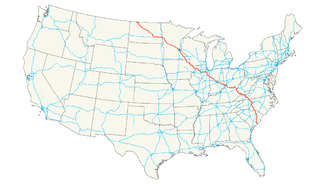
U.S. Route 22 is a west–east route and is one of the original United States highways of 1926, running from Cincinnati, Ohio, at US 27, US 42, US 127, and US 52 to Newark, New Jersey, at U.S. Route 1/9 in the Newark Airport Interchange. US 22 is named the "William Penn Highway" throughout most of Pennsylvania. In southwest Ohio, it overlaps with State Route 3 and is familiarly known as the 3C Highway, "22 and 3", and Montgomery Road.

Interstate 64 east-west Interstate in eastern US

Interstate 64 (I-64) is an Interstate Highway in the Eastern United States. Its western terminus is at I-70, U.S. Route 40 (US 40), and US 61 in Wentzville, Missouri. Its eastern terminus is at an interchange with I-264 and I-664 at Bowers Hill in Chesapeake, Virginia. I-64 connects the major metropolitan areas of St. Louis, Missouri; Louisville, Kentucky; Lexington, Kentucky; Charleston, West Virginia; Richmond, Virginia; Norfolk, Virginia; and Virginia Beach, Virginia.

U.S. Route 60 highway in the United States

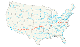
U.S. Route 60 (US 60) is an east–west United States highway, traveling 2,670 mi (4,300 km) from southwestern Arizona to the Atlantic coast in Virginia. Despite the final "0" in its number, indicating a transcontinental designation, the 1926 route formerly ended in Springfield, Missouri, at its intersection with the major US 66. In fact, US 66 was almost given the US 60 number.

U.S. Route 52 highway in the United States

U.S. Route 52 (US 52) is a major United States highway in the central United States that extends from the northern to southeastern region of the United States. Contrary to most other even-numbered U.S. Highways, US 52 primarily follows a northwest–southeast route, and is signed north–south or east–west depending on the local orientation of the route.

U.S. Route 21 highway in the United States

U.S. Route 21 (US 21) is a north–south United States Numbered Highway that runs 394 miles (634 km) from Hunting Island State Park, South Carolina to Wytheville, Virginia.

West Virginia Turnpike highway in West Virginia

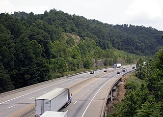
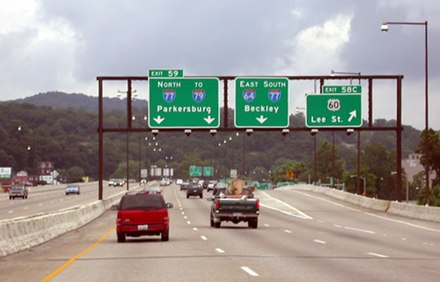
The West Virginia Turnpike is a toll road in the US state of West Virginia. It is also signed as Interstate 77 for its entire length as well as Interstate 64 from Charleston to just south of Beckley. From Beckley, the road extends south to Princeton. The Turnpike contains the only tolled sections of either Interstates 64 or 77.

Interstate 264 (I-264) is an Interstate Highway in the U.S. state of Virginia. It serves as the primary east-west highway through the South Hampton Roads region in southeastern Virginia. The route connects the central business districts of Chesapeake, Portsmouth, Norfolk, and Virginia Beach and serves as the most direct link between those cities and the resort beaches along Virginia's Atlantic coast.

In the United States, Corridor D is part of the Appalachian Development Highway System. It travels from Bridgeport, West Virginia to Cincinnati, Ohio. It travels US 50 for much of its eastern portion. The western portion of road in Ohio is known as State Route 32. ADHS Funding is separate from other Federal Highway funds.

West Virginia Route 622 highway in West Virginia

West Virginia Route 622 is a north–south state highway located entirely in Kanawha County, West Virginia. The southern terminus of the route is at West Virginia Route 25 west of Institute. The northern terminus is at Interstate 77 exit 114 north of Pocatalico.

West Virginia Route 114 highway in West Virginia

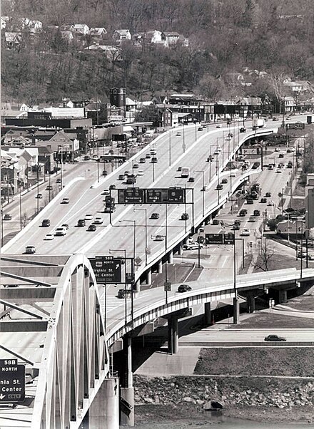
West Virginia Route 114 is a north–south state highway located in the Charleston, West Virginia area. The southern terminus of the route is at U.S. Route 60 east of downtown Charleston. The northern terminus of the route is at Interstate 79 north of Big Chimney.

U.S. Route 52 in West Virginia highway in West Virginia

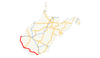
U.S. Route 52 (US 52) skirts the western fringes of the U.S. state of West Virginia. It runs from the Virginia state line near Bluefield, where it is concurrent with Interstate 77 (I-77), in a general northwest and north direction to I-64 at Kenova. There it turns east, overlapping I-64 for five miles (8.0 km) before splitting off onto the West Huntington Expressway into Ohio via the West Huntington Bridge. Despite having an even number, US 52 is signed north–south in West Virginia. In some other states along its route, it is signed east-west. The West Virginia segment is signed such that US 52 north corresponds to the general westward direction of the highway, and vice versa. For a while, US 52 parallels US 23, which is on the other side of the Big Sandy River in Kentucky. This continues into Ohio, where US 52 travels on the Ohio side of the Ohio River while US 23 travels on the Kentucky side.

In the U.S. state of West Virginia, Interstate 77 (I-77) is a major north–south Interstate highway. It extends for 187.21 miles (301 km) between Bluefield at the Virginia state line to Williamstown at the Ohio state line.

U.S. Route 460 in Virginia highway in Virginia

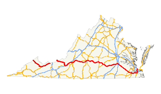
U.S. Route 460 in Virginia runs west-east through the southern part of the Commonwealth. The road has two separate pieces in Virginia, joined by a relatively short section in West Virginia. Most of US 460 is a four-lane divided highway and is a major artery in the southern third of the state.

In the U.S. state of West Virginia, Interstate 64 travels for 184 miles (296 km) passing by the major towns and cities of Huntington, Charleston, Beckley, and Lewisburg.

Corridor Q is a highway in the U.S. states of Kentucky, Virginia, and West Virginia. It is part of the Appalachian Development Highway System and U.S. Route 460. Corridor Q runs from Corridor B near Pikeville, Kentucky easterly to Interstate 81 in Christiansburg, Virginia.

The roads of Huntington, West Virginia include one major interstate highway, two U.S. highways, 6 state routes, and numerous major thoroughfares.

West Virginia Route 817 highway in West Virginia

West Virginia Route 817 follows the former path of U.S. Route 35 along the Kanawha River from St. Albans, West Virginia to near Fraziers Bottom, West Virginia and resumes again between near Southside to near Henderson. As such it is actually two separate roads, connected by the 12 mile "gap" in US 35, which will, when US 35 is finished, become WV 817 as well, making the eventual route of the road from St. Albans to Henderson. The route was first signed on October 10, 2008, the day when a new section of US 35 opened to replace this stretch of road. It was extended from Winfield to the current end of the four-lane US 35 near Fraziers Bottom on June 15, 2009 when the section of US 35 that replaced it was opened. The separate section was added on November 1, 2010, when another section of US 35 opened. While US 35 formerly ended at U.S. Route 60, its new path ends at Interstate 64.

References

  1. 1 2 3 4 5 6 Release Date Report. West Virginia Department of Transportation. August 2003.
  1. Cahal, Sherman. "Interstate 64." American Byways. 17 July 2005.