Sandy Spit

Last updated

Sandy Spit
Sandy Spit, BVI.jpg
Sandy Spit
British Virgin Islands location map.svg
Red pog.svg
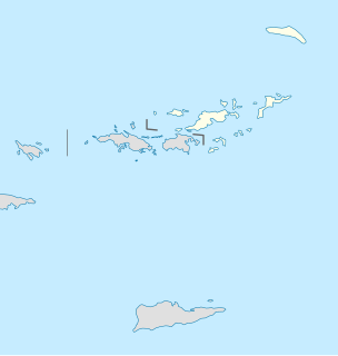
Sandy Spit
The location of Sandy Spit within the British Virgin Islands
Relief Map of Caribbean.png
Red pog.svg
Sandy Spit
Sandy Spit (Caribbean)
Geography
Location Caribbean Sea
Coordinates 18°26′59″N64°42′32″W / 18.44972°N 64.70889°W / 18.44972; -64.70889 Coordinates: 18°26′59″N64°42′32″W / 18.44972°N 64.70889°W / 18.44972; -64.70889
Archipelago Virgin Islands
Administration
United Kingdom
British Overseas Territory British Virgin Islands
Additional information
Time zone
ISO code VG

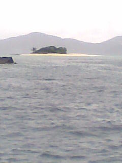
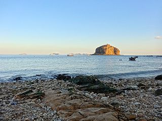
Sandy Spit is an uninhabited islet of the British Virgin Islands in the Caribbean, sitting midway between Sandy Cay and Green Cay. It measures less than half an acre in size, and consists entirely of a ring of sandy beach surrounding light foliage. It has the appearance of a classic paradise "desert island" and has been photographed for use in print medium in a number of advertising campaigns. Sandy Spit is a popular stop for day and term boat charters from Tortola, St. Thomas, and St. John. There are no moorings, but the sandy bottom is suitable for anchoring.

Islet A very small island

An islet is a very small island.

British Virgin Islands British overseas territory in the Caribbean

The British Virgin Islands (BVI), officially simply the Virgin Islands, are a British Overseas Territory in the Caribbean, to the east of Puerto Rico. The islands are geographically part of the Virgin Islands archipelago and are located in the Leeward Islands of the Lesser Antilles.

Caribbean region to the center-east of America composed of many islands and of coastal regions of continental countries surrounding the Caribbean Sea

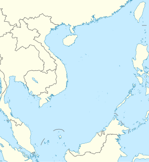
The Caribbean is a region of The Americas that consists of the Caribbean Sea, its islands and the surrounding coasts. The region is southeast of the Gulf of Mexico and the North American mainland, east of Central America, and north of South America.

Sandy Spit was nearly wiped out by Hurricane Irma. Half the beach is gone as of 12 September 2017.

Hurricane Irma Category 5 Atlantic hurricane in 2017

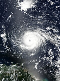
Hurricane Irma was an extremely powerful and catastrophic Cape Verde hurricane, the strongest observed in the Atlantic in terms of maximum sustained winds since Wilma, and the strongest storm on record to exist in the open Atlantic region. Irma was the first Category 5 hurricane to strike the Leeward Islands on record, followed by Maria two weeks later, and is the second-costliest Caribbean hurricane on record, after Maria. The ninth named storm, fourth hurricane, second major hurricane, and first Category 5 hurricane of the 2017 Atlantic hurricane season, Irma caused widespread and catastrophic damage throughout its long lifetime, particularly in the northeastern Caribbean and the Florida Keys. It was also the most intense hurricane to strike the continental United States since Katrina in 2005, the first major hurricane to make landfall in Florida since Wilma in the same year, and the first Category 4 hurricane to strike the state since Charley in 2004. The word Irmageddon was coined soon after the hurricane to describe the damage caused by the hurricane.

The island provides habitat for the crested anole (Anolis cristatellus wileyae), and the big-scaled least gecko (Sphaerodactylus macrolepis macrolepis). [1]

Big-scaled least gecko species of reptile

The big-scaled least gecko is a gecko mainly distributed in Puerto Rico, the United States Virgin Islands and the British Virgin Islands in the Caribbean. It is also found on the mainland in Costa Rica, Panama, and Colombia. It is one of over 100 species in the genus Sphaerodactylus.

Related Research Articles

Geography of Anguilla

This article describes the geography of Anguilla.

Sandy Hook peninsula in New Jersey

Sandy Hook is a barrier spit in Middletown Township, Monmouth County, New Jersey, United States. The barrier spit, approximately 6 miles (9.7 km) in length and varying from 0.1 to 1.0 mile wide, is located at the north end of the Jersey Shore. It encloses the southern entrance of Lower New York Bay south of New York City, protecting it from the open waters of the Atlantic Ocean to the east. The Dutch called the area "Sant Hoek", with the English "Hook" deriving from the Dutch "Hoek", meaning "spit of land".

Cay small island formed on the surface of a coral reef

A cay, also spelled caye or key, is a small, low-elevation, sandy island on the surface of a coral reef. Cays occur in tropical environments throughout the Pacific, Atlantic and Indian Oceans.

Abaco Islands group of islands in the Bahamas

The Abaco Islands lie in the northern Bahamas 180 miles (290 km) east of South Florida. They comprise the main islands of Great Abaco and Little Abaco, along with smaller barrier cays. The northernmost are Walker's Cay, and its sister island Grand Cay. To the south, the next inhabited islands are Spanish Cay and Green Turtle Cay, with its settlement of New Plymouth, Great Guana Cay, private Scotland Cay, Man-O-War Cay, and Elbow Cay, with its settlement of Hope Town. Southernmost are Tilloo Cay and Lubbers Quarters. Another of note off Abaco's western shore is onetime Gorda Cay, now a Disney Island and cruise ship stop and renamed Castaway Cay. Also in the vicinity is Moore's Island. On the Big Island of Abaco is Marsh Harbour, the Abacos' commercial hub and the Bahamas' third largest city, plus the resort area of Treasure Cay. Both have airports. A few mainland settlements of significance are Coopers Town and Fox Town in the north and Cherokee and Sandy Point in the south. Administratively, the Abaco Islands constitute seven of the 31 Local Government Districts of the Bahamas: Grand Cay, North Abaco, Green Turtle Cay, Central Abaco, South Abaco, Moore's Island, and Hope Town.

Private island island owned by a single private citizen or corporation

A private island is a disconnected body of land wholly owned by a single private citizen or corporation. Although this exclusivity gives the owner substantial control over the property, private islands remain under the jurisdiction of national and sometimes local governments.

Exuma Place in Bahamas

Exuma is a district of the Bahamas, consisting of over 365 islands, also called cays.

Trunk Bay

Trunk Bay is a body of water and a beach on St. John in the United States Virgin Islands. Trunk Bay is part of the Virgin Islands National Park. Trunk Bay is named for the Leatherback turtle, which is endemic to the U.S.V.I. and is locally known as trunks. The beach area is divided into two halves, the main Trunk Bay beach and swim area and Burgesman Cove which is located on the west end of Trunk Bay near Jumby Bay. Its amenities include a snack bar, showers and restrooms, a lifeguard, and an underwater trail for snorkeling its coral reef. Trunk Bay has consistently been voted one of the top beaches in the world.

North Caicos island

North Caicos is the second-largest island in the Turks and Caicos Islands. To the west, the Caicos Cays link to Providenciales. To the east, it is separated from Middle Caicos by Juniper Hole, a narrow passage that can accommodate only small boats. A 1-mile causeway connects North Caicos to Middle Caicos.

Waterhouse Island (Tasmania)

Waterhouse Island, part of the Waterhouse Island Group, is a 287-hectare (710-acre) granite island situated in Banks Strait, part of Bass Strait, lying close to the north-eastern coast of Tasmania, Australia.

Green Cay island in the British Virgin Islands

Green Cay is an uninhabited island of the British Virgin Islands in the Caribbean. It sits between the eastern tip of Little Jost Van Dyke and Tortola. It is 14 acres (6 ha) in area.

Waterlemon Cay is a small cay surrounded by a fringing reef located in Leinster Bay on Saint John, U.S. Virgin Islands. It is named after the water lemon.

Sandy Cay island in the United Kingdom

Sandy Cay is an uninhabited island of the British Virgin Islands in the Caribbean. It is located between Tortola and Jost Van Dyke. The island was owned by the Laurance Rockefeller Estate. On 1 May 2008, ownership of the island was transferred to the National Parks Trust of the Virgin Islands.

Prickly Pear (British Virgin Islands) island of the British Virgin Islands in the Caribbean

Prickly Pear is an uninhabited island of the British Virgin Islands in the Caribbean. Even though the island doesn’t have permanent residents, it has a beach bar and recreational water sports facility on it. It is located on the north side of North Sound, opposite Virgin Gorda.

<i>Cyclura cychlura inornata</i> subspecies of reptile

The Allen Cays rock iguana or Allen Cays iguana is an endangered subspecies of the northern Bahamian rock iguana that is found on Allen's Cay in the Bahamas. Its status is Endangered, with a wild population of 1,000 animals, and it can be found on the IUCN Red List.

Lankiam Cay island

Lankiam Cay10°43′N114°32′E is the smallest of the naturally occurring Spratly Islands. It has an area of 0.44 hectares, and is located about 7 nautical miles east-northeast of Philippine-occupied Loaita (Kota) Island, just west of the north of Dangerous Ground.

Sand Cay island

Sand Cay10°23′N114°29′E, also known as Son Ca Island is a cay on the north edge of the Tizard Bank of the Spratly Islands in the South China Sea. With an area of 7 hectares, it is the ninth largest, and the fourth largest former Vietnamese-administered, of the Spratly Islands. The island has been occupied by Vietnam since 1974,. It is also claimed by China, the Philippines, Vietnam, and Taiwan.

Index of Bahamas-related articles

The following is an alphabetical list of topics related to the Commonwealth of the Bahamas.

Stocking Island island in the Exuma region, Bahamas

Stocking Island is a small, long, narrow island off the port of Georgetown, Great Exuma Island, Bahamas. The island features beaches and several resorts.

Dog Island, Anguilla island in Anguilla

Dog Island is an uninhabitated small island of 207 ha in size located approximately 13 km (8.1 mi) to the north-west of Anguilla. It is low and rocky, with three small cays off the west and north coasts. The coastline is characterised by low cliffs alternating with sandy beaches. Large ponds lie inside two of the beaches. Dog Island lies west of the Prickley Pear Cays.

References

  1. Heatwole, Harold; Levins, Richard; Byer, Michael D. (July 1981). Atoll research bulletin - Biogeography of the Puerto Rican bank. 251. Washington D.C.: The Smithsonian Institution. p. 53. OCLC   45726059.