The British Virgin Islands (BVI), officially the Virgin Islands, is a British Overseas Territory in the Caribbean, to the east of Puerto Rico and the US Virgin Islands and north-west of Anguilla. The islands are geographically part of the Virgin Islands archipelago and are located in the Leeward Islands of the Lesser Antilles and part of the West Indies.

The British Virgin Islands (BVI) are one of three political divisions of the Virgin Islands archipelago located in the Lesser Antilles, between the Caribbean Sea and the North Atlantic Ocean. The BVI are the easternmost part of the island chain. The land area totals and comprises 16 inhabited and more than 20 uninhabited islands. The islands of Tortola, Anegada, Virgin Gorda and Jost van Dyke are the largest. Maritime claims include 12 nmi territorial sea and a 200 nmi exclusive fishing zone. In terms of land use, it is 20% arable land, 6.67% permanent crops and 73.33% other as of a 2005 figure. It has strong ties to nearby U.S. Virgin Islands and Puerto Rico.

The History of the British Virgin Islands is usually, for convenience, broken up into five separate periods:

Virgin Gorda is the third-largest island and second-most populous of the British Virgin Islands (BVI).

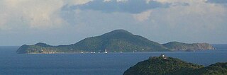
Anegada is the northernmost of the British Virgin Islands (BVI), a group of islands that form part of the archipelago of the Virgin Islands. It lies approximately 15 miles (24 km) north of Virgin Gorda. Anegada is the only inhabited British Virgin Island formed from coral and limestone, rather than being of volcanic origin. While the other islands are mountainous, Anegada is flat and low. Its highest point is only about 28 feet (8.5 m) above sea level, earning it its name, which is the Spanish term for the flooded land, "tierra anegada".

Road Town, located on Tortola, is the capital of the British Virgin Islands. It is situated on the horseshoe-shaped Road Harbour in the centre of the island's south coast. The population was about 15,000 in 2018.
Tortola is the largest and most populated island of the British Virgin Islands, a group of islands that form part of the archipelago of the Virgin Islands. It has a surface area of 55.7 square kilometres with a total population of 23,908, with 9,400 residents in Road Town. Mount Sage is its highest point at 530 metres above sea level.

Jost Van Dyke is the smallest of the four main islands of the British Virgin Islands, measuring roughly 8 square kilometres. It rests in the northern portion of the archipelago of the Virgin Islands, located in the Atlantic Ocean and Caribbean Sea. Jost Van Dyke lies about 8 km (5 mi) to the northwest of Tortola and 8 km (5 mi) to the north of Saint John. Little Jost Van Dyke lies off its eastern end.

Necker Island is a 30-hectare (74-acre) island in the British Virgin Islands just north of Virgin Gorda. The island is entirely owned by Sir Richard Branson, chairman of the Virgin Group, and is part of the Virgin Limited Edition portfolio of luxury properties. The whole island operates as a resort and can accommodate up to 40 guests, with additional room for six children.

Terrance B. Lettsome International Airport, previously known as Beef Island Airport, is the main airport serving the British Virgin Islands, a British overseas territory in the Caribbean. The airport serves as the gateway to just about all of the islands within the BVI. The airport is also a gateway for inter-Caribbean travelers headed to the nearby U.S. Virgin Islands. Many travellers fly into Beef Island, with the intention of taking a ferry to the other smaller British Virgin Islands. The airport is located on Beef Island, a small island off the main island of Tortola, to which it is connected by the Queen Elizabeth II Bridge.
East Seal Dog is an uninhabited islet of the British Virgin Islands in the Caribbean. It is located in a smaller sub-group of islands referred to as the Dog Islands, or more commonly, "The Dogs". Other islets in The Dogs include Little Seal Dog Island, West Dog Island and George Dog Island, all of which are to the northwest of Virgin Gorda.

Eustatia Island is a 30-acre island of the British Virgin Islands (BVI) in the Caribbean. The word "Eustatia" is a Greek derived word meaning, "good place to stay." The entire island, and a small neighboring island, Saba Rock, are under the same long term lease. The island is regularly featured and photographed for several publications and was listed as one of the top 20 most beautiful islands in the world in the December 2004 issue of Islands magazine.

Fallen Jerusalem is an uninhabited island of the British Virgin Islands in the Caribbean, located to the south of Virgin Gorda. It obtained its name from the large number of oversized volcanic boulders that are scattered over the island which give it the vague resemblance of a destroyed city. It was declared a wildlife sanctuary in 1959.

George Dog is an uninhabited island of the British Virgin Islands in the Caribbean. It is located in a smaller sub-group of islands referred to as "The Dogs" to the northwest of Virgin Gorda.
Cooper Island is a small island of the British Virgin Islands in the Caribbean.
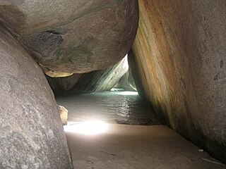
The Baths is a beach area on the island of Virgin Gorda among the British Virgin Islands in the Caribbean.
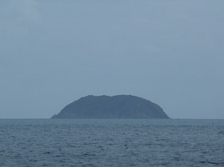
Round Rock is an uninhabited island in the British Virgin Islands, to the south of Virgin Gorda, east of Ginger Island and close to Fallen Jerusalem Island.

Chilabothrus monensis, also called commonly the Virgin Islands boa in the Virgin Islands, and the Mona Island boa elsewhere, is a species of snake in the family Boidae. The species is native to the West Indies. There are no subspecies.

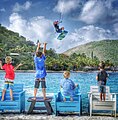
The Bitter End Yacht Club is a British Virgin Islands resort located in the protected North Sound of Virgin Gorda. Founded in 1969, the resort is only accessible by boat.

The effects of Hurricane Irma in the British Virgin Islands were significant in terms of both human and socio-economic impact on the Territory. Hurricane Irma struck the British Virgin Islands as a Category 5 hurricane during the daylight hours of Wednesday, 6 September 2017. It caused widespread destruction, and killed a total of four people. The eye of the hurricane traveled over the three major islands in the group: Virgin Gorda, Tortola and Jost Van Dyke.